
7 minute read
Ngā moutere o te moana ā Toi


Kaore hoki te mate, whanawhana i roto Me kawe rawa e ahau, nga roro whare ki Pakipaki Whakatauki mai, naumai ki ahau Kā wiri te haere, e pura ana te kanohi Ki te titiro mai ki ahau, motu koura ko Whakaari Motu kuia ko Rūrima, motu mana ko Moutohorā Puke i ahua e te tipua ki Pūtauaki, moana i takaia e Toi
Mai i ngā kurī ā Whārei, ki Tihirau, tūturu whakamaua kia tīnā, tīna, hāumi ē hui ē, Tāiki ē
Advertisement
The Rūrima Islands
The Rūrima Māori Reservation includes the islands of Rūrima (Te-kauae-ōWaitaha), Moutoki, and the reef Tokatā, that has a total area of approximately 11.5313 ha. The islands are located 19 kilometres west of the Whakatane River and 6 kilometres north from the Rangitāiki River. The islands were “Set aside as a Māori Reservation for common use of Māoris of the Ngāti Awa of Bay of Plenty, as a fishing and flora and fauna reserve” by way of Gazette Notice on 23 July 1953 and is vested in Trustees.
Rūrima Islands are also managed by DOC as a Wildlife Refuge.
There is speculation as to the genesis of the name Te-kauae-o-Waitaha which was so given because that chiefly gentleman seeking to quench his thirst whilst exploring the more prominent of the islands drove his taiaha into the ground at the base of a group of rocks and lo and behold water gushed forth, however in his haste to seek comfort from the spring he stumbled and is reputed to have broken his jaw against the rocks, hence the name Te-kauae-ō-Waitaha.


MOUTOHORĀ
Moutohorā lies approximately 8kms directly offshore from the Whakatāne Airport and some 11kms from the township of Whakatāne. The island is 2.4km long, about 1km wide and 353m at its highest point and is 143ha in area. The island is well known for geothermal pools traditionally used for cooking kai and medicinal purposes. Kuia/ Oi (Grey Faced Petrels) were also traditionally harvested in November. Unique cultural sites on Moutohorā incude;
• Motu-hara-paki (The Highest Peak) • Raetihi Kōangiangi-kāwatawata Pā (the Summit of Gentle Breezes) • Te Puna wai (Freshwater Spring) • Te Pari Kawau (Urupā) • Te One-roa (The Elongated Bay) • One-te-uru (Western Kaimoana Bay) • One-te-raki (Northern Kaimoana Bay) • Te Rā-whiti Māra Kūmara (Kūmara Gardens) • Te Rā-tahi (Boulder Bay)
TE PAEPAE KI AOTEA, KI HAWAIKI
The threshold of the living to Aotea and departing place of the spirits to Hawaiki. Now referred to as Te Paepae ki Aotea A group of three small islands, some three miles distant from Te Puia Whakaari off the Eastern Bay of Plenty coast within the rohe of Mataatua. These islands are of unique cultural, historical significance to Ngāti Awa as they are recognised as important links to the spiritual homelands and the departing place of the spirits.
Te Paepae ki Aotea Marine Reserve which encircles the island, was established in 2006. The area is popular with divers, due to good visibility (35-40m), spectacular scenery and colourful marine life.
Te Paepae ki Aotearoa ki Hawaiki The threshold of the living to Aotearoa The departure place of the spirits to Hawaiki
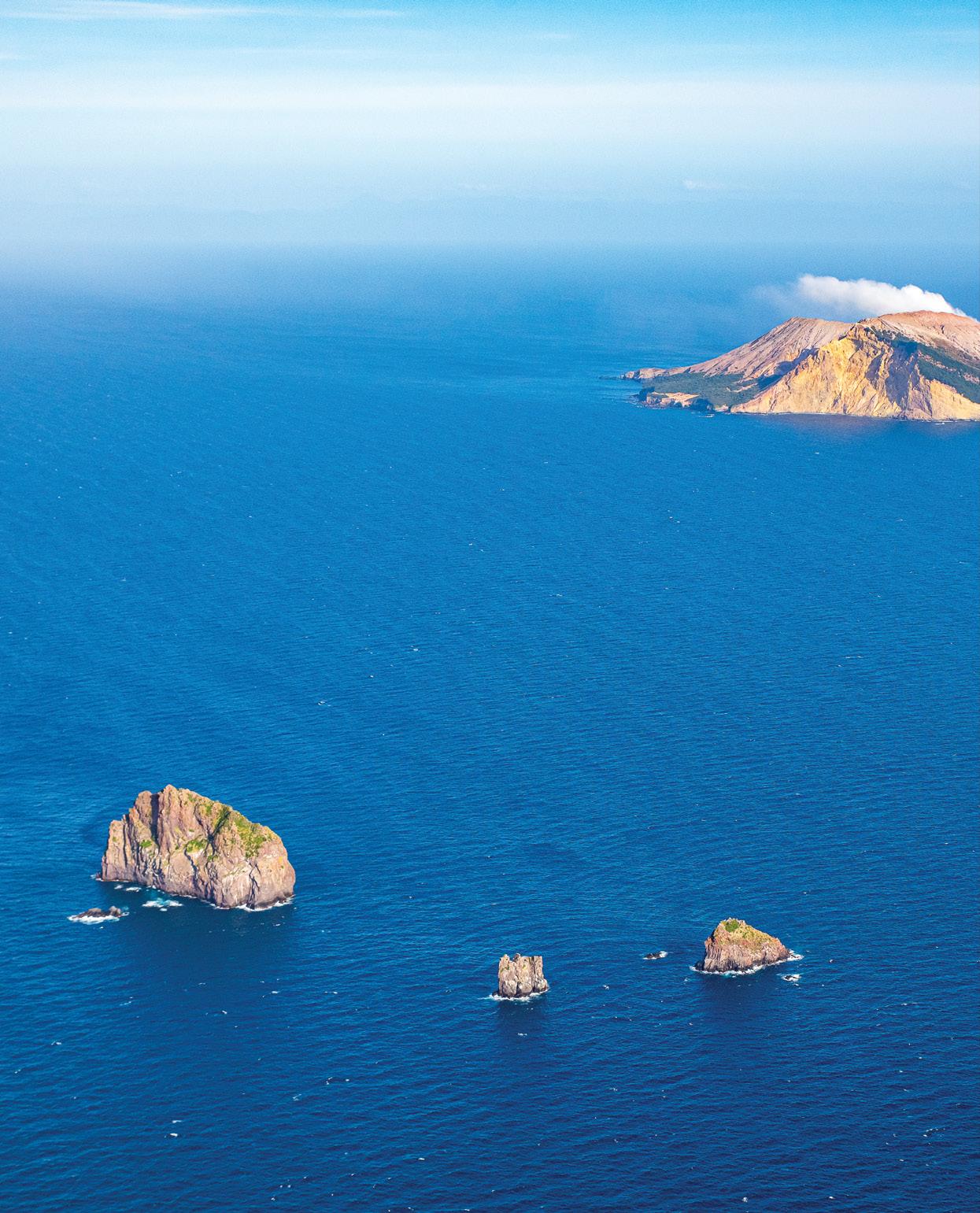
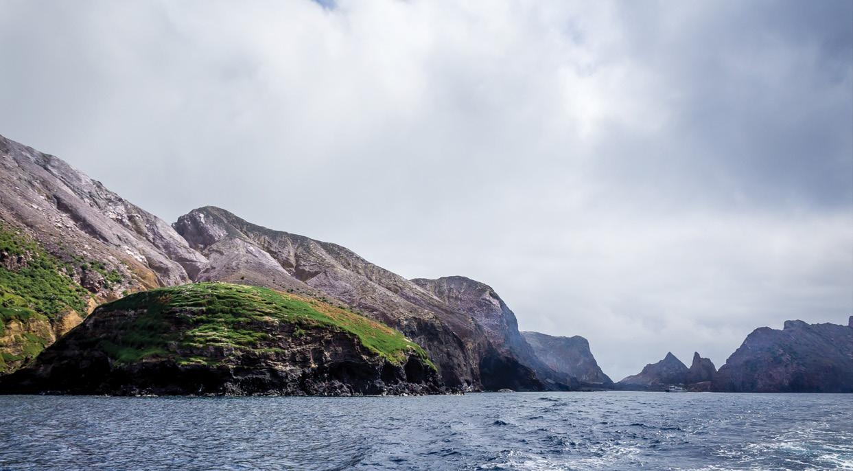
TE PUIA Ō WHAKAARI
Te Puia ō Whakaari has always been a well-known landmark in the Whakatāne area. Alongside Moutohorā the two islands form the northern end of a line of andesite volcanoes which continues in a south-westerly direction to Pūtauaki and Tarawera and the peaks of the central North Island. The island is almost continually active, it lies 51 kilometres north of Whakatāne and covers an area of 588 acres (238 hectares). White Island is the name that Captain Cook gave on his first visit to New Zealand. The island is privately owned; legally its status is that of a private reserve.
Some generations ago there lived near Whakatāne, in a village a few miles from the mouth of the river, a notorious tohunga named Te Tahi ō te Rangi (‘The First of the Heavens’).
His magic was famous throughout the island; and though he often used his powers to do good, it was chiefly for his black magic that he was known. It was true that they needed the tohunga to perform ceremonies when there were fishing expeditions, when the kumaras were planted and when the tribe made war on its neighbours. But in spite of this, his presence filled them with such fear that they plotted to kill him. However, they did not dare to attack him, for it was forbidden to shed the blood of a tohunga. Because of this they thought of an alternative and they planned a mutton-birding expedition out to Te Puia ō Whakaari, and when all was ready, they asked Te Tahi O Te Rangi to accompany them. The tohunga agreed, they reached the island that afternoon and when evening came they lit their torches and went to work. Te Tahi O Te Rangi, struggling up the dark slopes with the others, did his share of work like the rest of them.
After this they lay down to sleep. Since Te Tahi ō Te Rangi was a tohunga, his bed was some distance away from the others, and he slept particularly soundly.
The next morning he slept in, and when he woke there was no-one in sight, he went down to the beach there was no-one there. Then he looked out to sea and saw in the distance his people in their canoe, all paddling furiously back to land. Since they could not shed his blood they had left him on the island to die; for there is only sulphur and steam on White Island, nothing grows and there is no water.
But there was one thing these people didn’t know, one mistake they made. Hidden around his waist Te Tahi O Te Rangi wore a magic girdle, made of three tapu strands of flax. He took this off now, held it up in the air, and began to chant a prayer of help to Tangaroa. After a time Tangaroa heard the tohunga, and sent Tūtarakauika the demon whale. Te Tahi ō te Rangi climbed on to the whale’s huge back and sped away across the surface of the sea. Soon they came to the people in the canoe. When the people saw him coming, they nearly died of fright; they covered their faces with their hands and thought that their last hour had come.
Te Tahi O Te Rangi did not harm them, but as the whale rushed past, he did a furious haka, stamping his feet, leaping into the air and yelling a war-song. When the people heard this, they were still more frightened, and greatly regretted their mistake. When they beached their canoe and went back to the village, they were feeling very ashamed of what they had done. They came to the place where they had to walk beneath the great grey rock on which Te Tahi O Te Rangi was accustomed to sit; they looked up, and there was the tohunga, looking as though he had never moved, glaring down fiercely at them and not saying a word. One by one, not saying a word either, and, greatly ashamed, the people walked beneath him along the path.
When he was asked why he did not use his magic to destroy his faithless people, Te Tahi O Te Rangi replied, “Waiho rātou mā tō ratou whakamā hei patu”, ‘No, let their shame be their punishment’; and this saying has become proverbial among Ngāti Awa whenever the tribe’s mana is demeaned.
Tūturu whakamaua kia tīnā, tīnā, hui ē, hāumi ē, tāiki ē.
To learn more visit our online catalogue www.ngatiawa.iwi.nz
URETARA ISLAND
Uretara Island is situated in the Ōhiwa Harbour, it is 73.3 hectares in area, and is densely covered in secondary and tertiary growth, mainly Kānuka forest, Pōhutukawa, Wattle and Mānuka. In 1984 the island was classed as a Scenic Reserve as many different bird species inhabited the island as well as other animal species. Although the island has been modified by human activity the remains of pā sites, middens etc are still discernible. In 1986 the NZ Archaeological Association visited the island and identified at least two large pā sites. It is estimated that the larger pā site, Paripari, would have been capāble of supporting approximately 500 people. In 1866 Uretara was confiscated by the Crown.


