7 minute read
Revealing Complex Subsurface Areas in Shallow Water´s Gulf of Mexico, by Using OBC Acquisition Data and Depth Imaging Techniques

from Boletín 1, Vol.3

J. Jurado Ramírez (WesternGeco), C. Romero Rodríguez (WesternGeco), F. Fenoglio (WesternGeco), L. Mulisheva (WesternGeco), A. Bustos (PEMEX), J. Ruíz (PEMEX), N. Ortiz (PEMEX), S. Cruz (PEMEX), S. Domínguez (PEMEX), M. Bolon (PEMEX)
CMP 2019 Artículo presentado en el CMP / 2019
Advertisement
Summary
Petroleum Exploration is most challenging in complex geological settings. For example, in cases where salt and high velocity carbonates impact the image of the reservoir. This situation requires robust seismic acquisition techniques such as ocean-bottom cable (OBC), since it can provide long offset and full azimuth data to better illuminate subsurface structures, reducing uncertainty in the exploration process.
The implementation of appropriate Depth Imaging Techniques is important to generate high quality seismic images that help the exploration process. In our case, it was important to take advantage of the full azimuth and long offset information that had been acquired. The use of Offset Vector Tiles (OVTs) and RTM Subsurface Azimuth Angle Gathers (SAAGs) in Multi-azimuth tomography constrained by well data enabled us to build a velocity model that honors the geophysical measurements as well as the geological information. A key step was the incorporation of the geological model during the velocity model building. Localized Seismic Imaging (LSI) scenario testing was an important tool for reducing the turnaround time during the modeling of different Salt Geometries and Carbonate bodies.
Introduction
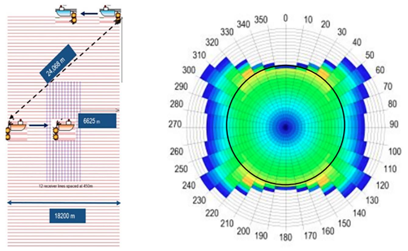
In this paper, we present a shallow water case study from the Gulf of Mexico near the coast of Tabasco, where a large OBC seismic survey has recently been acquired with simultaneous source acquisition using two source vessels (Figure 1). The objective of the new seismic acquisition was to produce well-sampled and robust seismic data that can benefit from the latest developments in seismic data processing as well as new Depth Imaging techniques that incorporate the geological information into the velocity model building. Previous narrow azimuth (NAZ) surveys could not produce high-quality images at target level due to the lack of azimuthal illumination.
Figure 1. Acquisition layout and Rose diagram showing offset and azimuth distribution from an OBC survey acquired in shallow water Southern Gulf of Mexico.

Illumination advantages of long offset and full azimuth information
To produce high-quality images below complex overburden requires seismic data with full azimuth and long offsets. This is especially important when the scale of subsurface heterogeneities is smaller than the streamer spread length. Full azimuth information provides:
Better attenuation of multiples More unique ray paths due to more azimuths More information for derivation of earth properties in velocity model building Better illumination for imaging of complex structures below large velocity contrasts
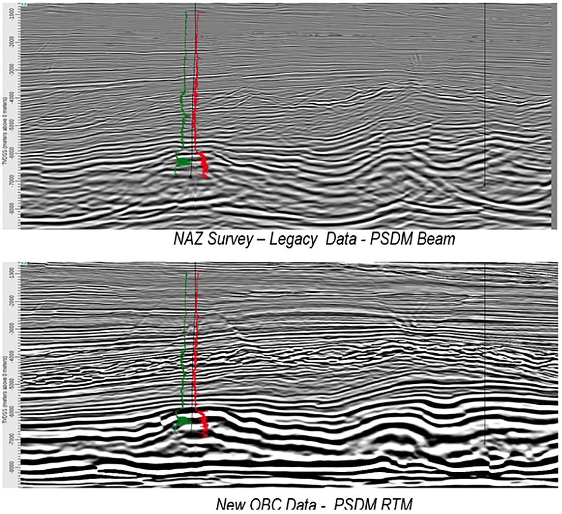
Figure 2. Comparison of depth images from legacy NAZ survey (above) and new OBC survey (below).
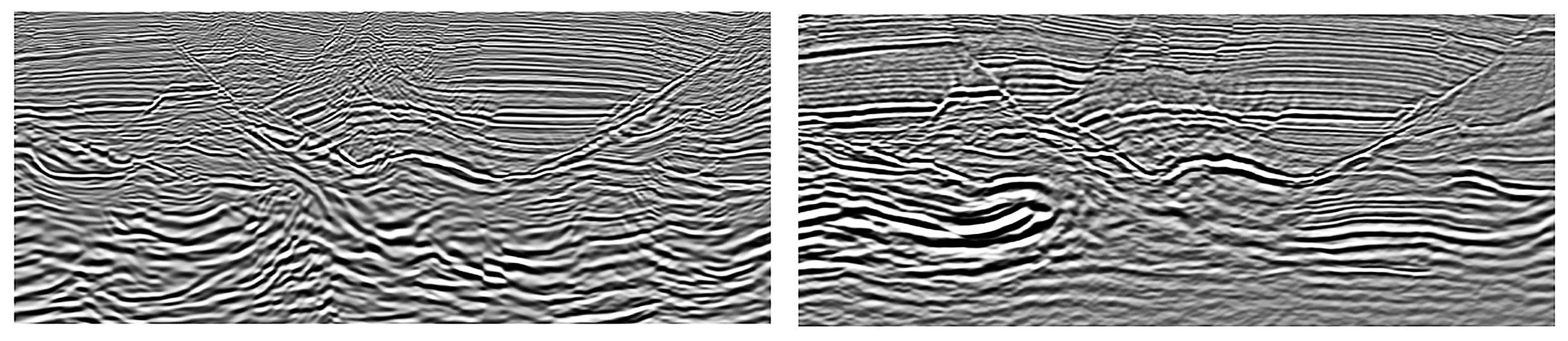
The above images show how the new OBC data provides better fault definition, less multiple contamination and more reliable amplitudes than a legacy NAZ survey. The OBC data also gives a better picture of the geology, especially at Mesozoic level, due to better subsurface illumination.
Methodology
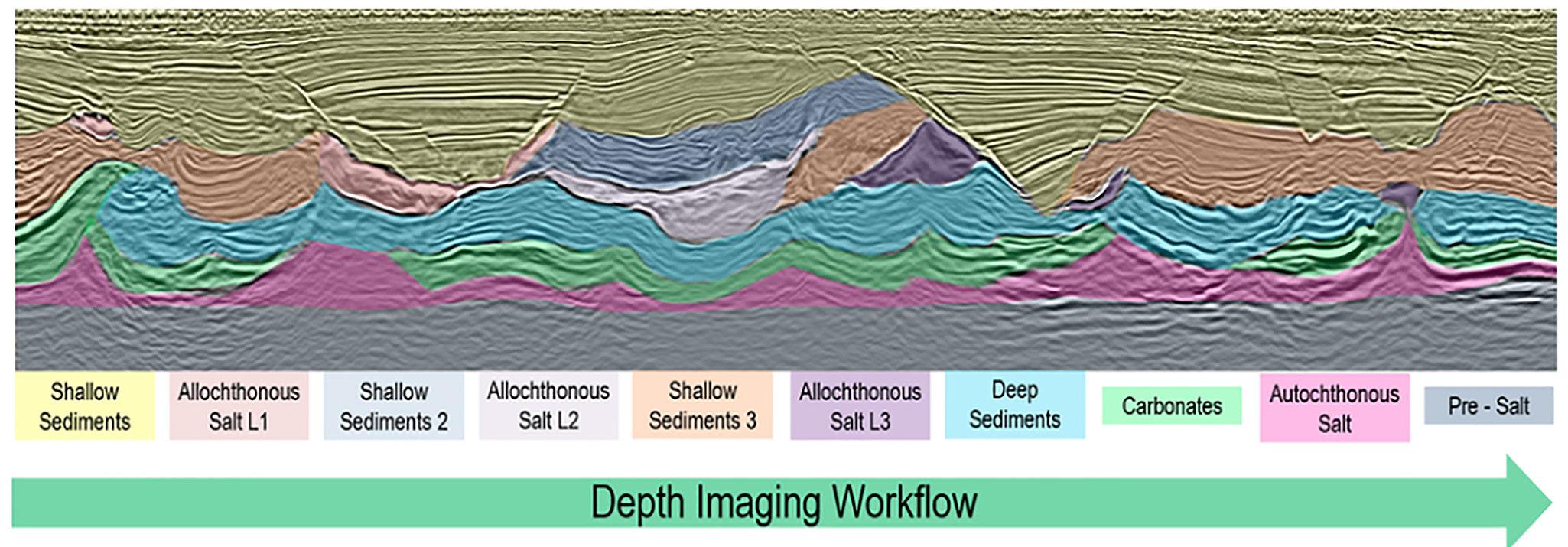
As mentioned above, full azimuth seismic data provides more information about the earth properties for velocity model building. Because of this, it is important to design a depth imaging workflow that takes advantage of the new acquisition. It is also important that the workflow considers all available geological information about the subsurface to produce the best possible velocity model that enables us to generate a high-quality image and reduce exploration uncertainty. Figure 3 shows the depth imaging workflow that we used, which proceeds from shallow to, deep through sediments and salt layers to the base of the model.
Figure 3. Depth Imaging Workflow.
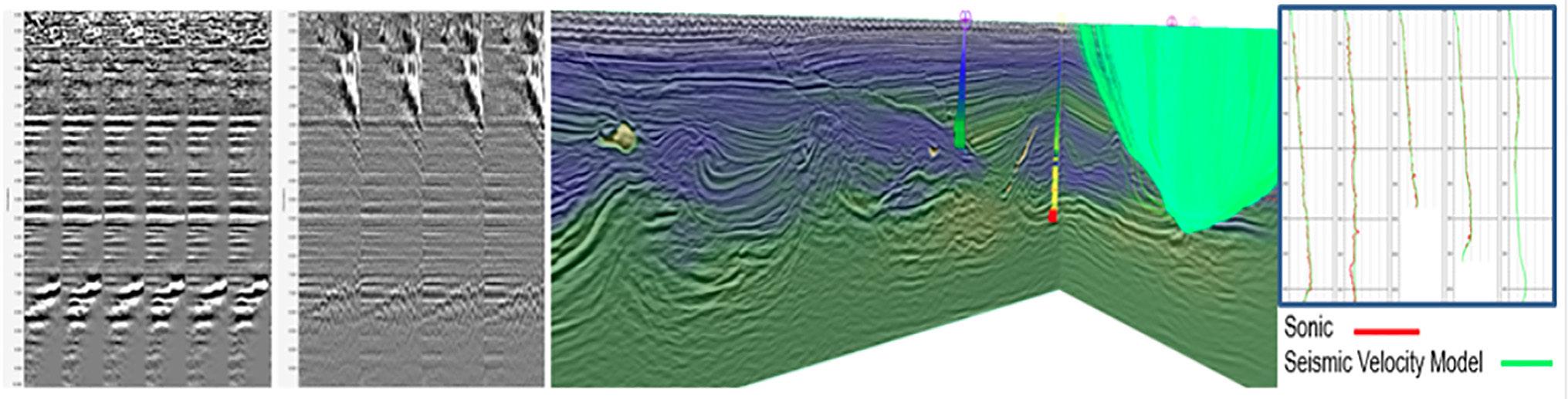
Velocity Model Building in complex areas requires the implementation of different technologies in order to produce a reliable model. In our case Kirchhoff PSDM (KDM) could not generate a good image in areas affected by complex overburden such as salt. KDM offset gathers

combined with RTM angle gathers allowed us to obtain better velocity updates, producing a better image. Additionally, well information was included during tomography, helping to constrain the model to be consistent with subsurface geological data. Figure 4 shows these components of a tomography iteration.
Figure 4. Integration of RTM Angle Gathers, KDM Offset Gathers, and well information for Velocity Model Update.
Allochthonous salt modeling plays a key role in the generation of a quality subsalt image, as improper salt geometry may lead to false structures. In this particular area there are different emplacement levels of Allochthonous salt which, require three different stages of modeling with velocity updates between the salt bodies to properly map the older emplacement levels.
Figure 5. Salt Modelling Example.

Localized Seismic Imaging (LSI) scenarios were implemented in order to efficiently evaluate different Salt geometries and reduce the uncertainty in the subsalt image. Figure 5 shows typical allochthonous salt bodies after salt modelling.
It is known that seismic moveout provides information about earth properties, giving a clear indication of the velocity of subsurface layers. Based on this, it is possible to use the velocity perturbation (DV) from tomography to identify velocity contrasts related to a particular lithology. This helps greatly with interpretation for velocity model building in areas of high uncertainty. For example, positive velocity updates in red in the deep section in Figure 6 likely indicate the presence of carbonates.
Figure 6. Exploration Tomography to aid interpretation.

A key point during the process of velocity model building for depth imaging is modelling, not only for salt, but also for areas with high velocity contrast such as carbonates. Due to tectonics that have affected the area there is overthrust faulting at the Mesozoic level. The Mesozoic carbonates have a much higher velocity than surrounding clastic sediments. Therefore, to produce a clear image of the Mesozoic carbonates in areas affected by overthrust faulting it is imperative to have a correct representation of the sediment velocities and of the geometry of the faulted blocks.
Localized Seismic Imaging (LSI) was used to test different scenarios and find the best model in these carbonate overthrust areas. In Figure 6, once the overlying carbonate block is correctly modelled, we see that the fault is better imaged. Also, the top carbonate for the underlying block has better continuity, amplitude and position. This enables more confident interpretation to represent the geology in the velocity model.
Figure 7. Over-thrust Structures modelling.

Results
As a result of the application of an integrated geophysical solution from acquisition through depth imaging, it is possible to obtain new seismic images of the subsurface that help to improve the geological knowledge in the area and show more geological features that can lead to new prospects and reduce the uncertainty in the exploration process.
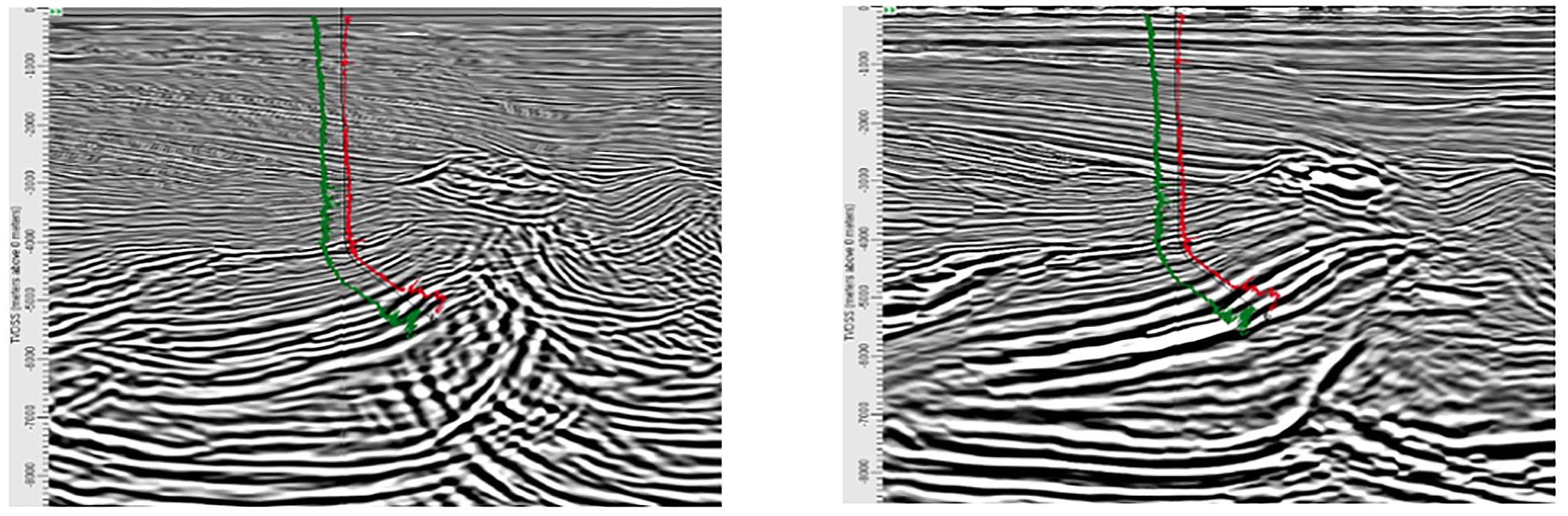
Figure 8. Comparison of depth images from legacy NAZ survey (top) and new OBC survey (bottom).
In figure 8 and 9, see comparisons of OBC and legacy NAZ data. The OBC image shows more reasonable structure and less migration noise, which makes interpretation easier and reduces uncertainty.
Figure 9. Comparison of depth images from legacy NAZ survey (left) and new OBC survey (rigth).
Conclusions
Acquisition of an OBC seismic survey provided full azimuth and long offset seismic information, giving better illumination of the complex geology in the area than a legacy NAZ survey.
It is important to define a Robust Depth Imaging workflow that considers the Geological Background in order to implement the best technologies at the right time to produce a high-quality image that will reduce uncertainty in the exploration process.
As a result of our Robust Geophysical Solution from Acquisition to Imaging, it is possible to consider and also to confirm new geological models in the area, opening many more exploration opportunities.
Acknowledgments
We thank PEMEX and WesternGeco for permission to publish this case study. Many thanks to all who have been associated with this project.
References
Woodward, M., D. Nichols, O. Zdraveva, P. Whitfield and T. Johns, 2008, A decade of tomography: Geophysics, 73, 5-11.
Vyas, M., X. Du, E. Mobley and R. Fletcher, 2011, Methods for Computing Angle Gathers Using RTM: 73rd Conference and Exhibition, EAGE, Extended Abstracts.


