
5 minute read
SITE 5: URBIC TECHNOSOL AT ‘MUINKPARK

from Soils and the city: man shaping the Ghent urban landscape, hydrology and soils - excursion
by soil-belgium

Aim
At this excursion site, we will: Introduce the geomorphology and history of the former ‘Muinkmeersen’ Touch upon ‘cultural layers’ in urban environments Discuss the features of an ‘old’ Urbic Technosol developed in human-transported and humanmade material
Advertisement
General information
Location
Muinkpark Nearby address: Hertstraat 62, 9000 Gent Coordinates : 51° 02’ 31.92’’ N, 3° 43’ 49.80’’ (WGS1984) 105236 m X; 192637 m Y (Lambert72) Elevation 7.2 m a.s.l.(Digitaal Hoogtemodel Vlaanderen II, 1m resolution, altitudinal reference: TAW/DNG) Profile description authors Nele Delbecque, Stefaan Dondeyne Approach 10 cm diameter soil column cylinder auger mounted on gasoline driven mechanical hammer
Soil formation factors
Geomorphology and geology
The Muinkpark is located in the former Muinkmeersen (marshes of the monks), which refers to the lower area of marshes and meadows besides the Sint-Pietersabdij, in the floodplain of the river Scheldt (Figure 0.1). Holocene alluvium covers the Pleistocene fluvio-periglacial sediments (Figure 0.6).
Land use and vegetation
In the 12th century a watermill, known as the Clapschiete, was built on a straightened canal, the Muinkscheldt. The watermill was property of Sint-Pietersabdij. The navigation used the old branch of the Scheldt: the Old Scheldt. In 1297, the city constructed a big watermill a few hundred meters downstream, which announced the end of the watermill of the abbey. From that moment onwards, the Muinkscheldt could be used as channel for ships. The Old Scheldt river remained to cross the Muinkmeersen for centuries. Due to annual flooding, the Muinkmeersen remained unurbanized until the 19th century and were used as pasture and meadows to feed livestock. In addition, the proximity of water made it the ideal location for the bleaching of textile, as nicely illustrated by the painting of Wynantz (19th century; Figure 5.1) (Gelaude, 2018).
In 1837, Ghent welcomed the first train (line Ghent-Mechelen), which entered the city through the - until then - unexploited Muinkmeersen. The first large train station ‘Ghent South’, was built in what is now the ‘Koning Albertpark’ , also known as ‘Zuidpark’. In 1851, following the success of the zoo of Antwerp, a part of the Muinkmeersen became home of the ‘Gentse Diergaerde’ or ‘Den Biestehof’, which hosted a collection of exotic animals (Fig. 5). Unfortunately, the zoo was bankrupted in 1904 and was bought and parceled out by the city of Ghent. The current ‘Muinkpark’ (1,3 ha) is the only remain of the once 5.5 ha large zoo (Stad Gent, 2016a; Muinkparkwijk, 2018a, 2018b).
Figure 5.1. View on the ‘Muinkmeersen’ (in front) and the Sint-Pietersabdij (in the back) (Wynantz 18201823, SAG)

Figure 5.2. Litho by Van Loo, F. on the 5.5 ha large zoo ‘Gentse Diergaerde’, end 19th century
The Muinkmeersen is an illustrative example of human impact on the landscape, soils and hydrology in Ghent. Surrounded by wetlands, the development and expansion of Ghent implied that the natural hydrographic system had to be altered. Human interventions included the straightening of rivers, construction of weirs, bridges and dikes and reinforcing of riverbanks (Gelaude, 2010). Other solutions included the elevation of lower areas with anthropogenic fill. Note that the presence of these ‘cultural layers’ is not isolated to locations with (former) lower elevation, as cities were often built on their own ‘garbage’. Consequently, these so-called anthropogenic fills tend to have high contents of artefacts like construction debris or household waste. In Moscow (Russia) for example, cultural layers of up to 20 m depth have been reported (Alexandrovskaya and Alexandrovskaykiy, 2000; Alexandrovskaya and Panova 2003).
Also in Ghent, evidence of anthropogenic fill is plentiful. The ‘Grondmechanische Kaart Gent’ (1:5 000) (De Beer et al., 1976) maps the geological and ground-mechanical state of the subsurface and provides an indication of the thickness of by human-transported material (Figure 5.3). According to the map, the former Muinkmeersen were raised with 0-2 m of anthropogenic fill.

Figure 5.3. Thickness of raised and reworked ground with which the former relief was elevated / levelled as given by De Beer et al. (1976). The Muinkpark is indicated by a red dash line.
27

Figure 5.4. View on the raised Muinkmeersen (SAG)
Soil description, analysis and classification
The descriptive and lab analytical data for the soil profile collected in Muinkpark are given in Figure 5.5 and Table 5.1, respectively. The soil classifies (IUSS Working Group WRB, 2015) as Urbic Technosol (Calcaric, Humic, Mollic, Loamic, Pantotransportic). The soil profile entirely consists of human-transported and artifactic material (Pantotransportic). Especially horizons dUA2-1 and dUA2-2 have abundant artefacts, which mainly consist of construction debris (bricks, plaster) (Urbic qualifier). Yet, this anthropogenic soil profile shows evidence of pedogenesis: the upper horizons (Ahu1, Ahu2, Ahu3) show well-developed soil structure with high amounts of humified organic matter, which together qualify as mollic horizon.
Apart from the upper horizon Ahu1 (pH-KCl = 6.0), the entire soil profile shows an alkaline soil reaction (pH-KCl ≥ 7.2). The presence of carbonates was indeed quantified through a HCl (10%) test, indicating that the soil matrix is moderately to strongly calcareous. Nonetheless, analytical results generally indicate low amounts of inorganic carbon, as most of the carbonate containing artefacts is pertained as coarse fraction (>2mm).
The entire profile has a high total organic carbon content (TOC). Although a significant part of the TOC corresponds to technic carbon (ashes, hard coal), the profile is likely Humic (>1% of OC hum in upper 50 cm). Note that whereas Technosols tend to be perceived as infertile, this soil profile resembles a fertile soil with a mollic horizon with sufficient nutrients, and having a high organic matter content throughout, thereby functioning as a carbon sink.
Table 5.1. Physico-chemical properties by horizon of the soil profile at ‘Muinkpark’. (EC = electrical conductivity; TOC = total organic carbon; OChum = soil organic carbon; OCtech = technic organic carbon; TIC = total inorganic carbon; CF = coarse fraction (> 2mm). Prefix ‘^’ in horizon name refers to dumped material, their codes can be looked up in Guidelines for Soil Description (FAO, 2006).
Depth pH-KCl EC TOC OChum OCtech TIC Sand Silt Clay CF Horizon (cm) (-) (µS·cm-1) (%) (%) (%) (%) (%) (%) (%) (%)
^Ah 0-10 6.0 317 6.9 5.1 1.8 0.0 80.7 6.4 12.9 7 ^Auh1 10-18 7.3 140 3.6 1.3 2.3 0.1 81.1 9.8 9.1 24 ^Auh2 18-23 7.2 128 4.1 2.3 1.7 0.1 61.8 22.6 15.6 14 ^Cuk 23-50 7.2 141 1.2 1.0 0.2 0.1 38.5 32.4 29.1 10 ^Cu1 50-65 7.2 168 1.4 1.1 0.3 0.2 67.3 15.5 17.2 74 ^Cu2 65-80 7.4 182 1.1 1.1 0.0 0.9 63.3 28.7 8.0 51 ^Cu3 80-95 7.4 146 2.0 1.3 0.6 0.8 60.4 33.4 6.2 41 ^Cu4 95-120 7.4 148 1.1 1.0 0.1 0.4 72.3 23.5 4.2 23
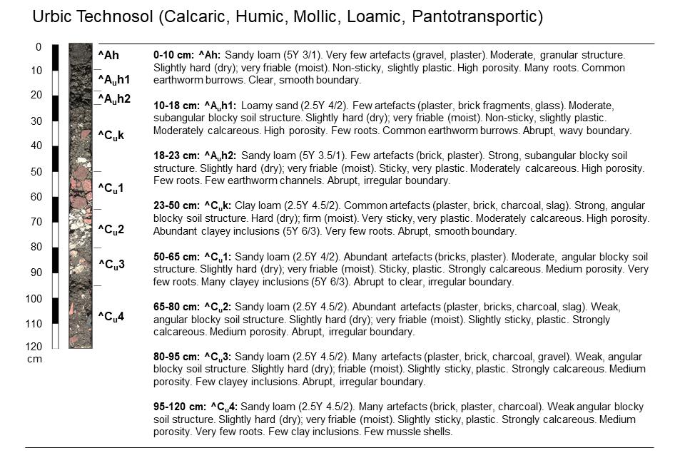
Figure 5.5. Morphological description of soil profile at ‘Muinkpark’.
29


