5 minute read
The rising satellite radar technology shaking up government and commercial markets

Government agencies and many different commercial industries can benefit from Synthetic Aperture Radar (SAR) which is now readily available. This is because SAR delivers high-quality imagery and data that is critical both to infrastructure planning and disaster relief.
Yuto Shiba, Manager, Product and Customer Engineering, and Reina Saiki, Business Strategy Officer, at Synspective

Reina Saiki, Business Strategy Officer, Synspective

Yuto Shiba, Manager, Product and Customer Engineering, Synspective
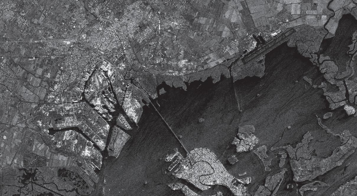
SAR – or Synthetic Aperture Radar – technology is a powerful, growing, and transformative method designed to detect changes on Earth. SAR satellites are unique in their ability to illuminate the ground without being dependent on sunlight like optical observation satellites. They capture an unprecedented level of detail, consistency, and range in imagery.
Not being limited by cloud cover or low visibility at night, SAR satellites provide an unobstructed and informative view of Earth and ground movements. SAR data contains information that contributes to understanding the shape and physical properties of terrain and structures. It can also monitor objects, such as vehicles in urban cities, buildings in disaster-prone areas, and maritime vessels at major ports. This makes SAR satellites suited to time-series analysis and the capture of continuous changes for a number of applications across land and sea.
Thanks to advances in design and computing as well as falling launch costs, small satellites have become more widely available. Being cheaper and lighter than more traditional satellites, they are increasing access to space. It is now possible to deploy multiple SAR satellites from a single payload. The availability of small SAR satellite constellations makes near real-time observations of the entire planet possible with unmatched details and highresolution image clarity.
GOVERNMENT DEMAND FOR SAR DATA
SAR satellites are informing critical decisions for the benefit of governments. Their observation capabilities are enabling information gathering, communication, and positioning from all regions of the world. This will lead to greater global transparency and will be instrumental in serving defense and intelligence communities in many ways. Detailed and reliable Earth observation data can yield a fuller understanding across human and resource-affiliated conflicts and help defuse them. They can also help governmental and intergovernmental bodies uphold treaties and by locating crimes that take place on land and sea.
Man-made and natural disasters are on the rise. During emergencies, SAR technology detection of changing conditions can provide much needed data and information for decision-making which results in more effective disaster reduction and preparation actions. Governments need to be adaptive and adept at addressing natural disasters and extreme weather activities from flooding and fires to hurricanes. High-resolution SAR imagery can cover the extent and damage of a disaster and be an indispensable source of information both during and after a disaster. In addition, SAR’s unique temporal and spatial resolution is key to developing early warning systems that can help identify hazards and improve disaster relief and response efforts.
COMMERCIAL DEMAND FOR SAR DATA
While governments have been the biggest customers for Low Earth Orbit (LEO) imaging, commercial players and applications are expected to grow over the next decade. All-weather SAR satellites and the data they generate are best positioned to develop solutions infrastructure, insurance, and finance. Companies in these areas are interested in the information obtained from SAR satellites and other data sources because they can play a key role in informing strategic decisions. Let us count the ways.
With infrastructure planning, construction projects will be able to use data that highlights potential high-risk areas and advise businesses to build structures capable of withstanding land movement and geological hazards. SAR data can analyze long-term impact and susceptibility to disasters, which can help insurance companies keep pace with global changes, estimate losses quickly, and streamline their payment of claims for customers. In finance, where ESG investing has grown, SAR data can support climate-resilient assets and help institutions measure emissions and nature-based offsets.
CAPTURING THE WORLD, ONE SATELLITE AT A TIME
Synspective, a startup born out of Japan’s ImPACT program, is breaking new ground with its SAR capabilities, and looking to optimize its technologies to meet the challenges of a changing world. The Tokyo-based startup is building a small SAR satellite constellation that will generate data and address bottlenecks for the benefit of governments and commercial customers alike. The company currently has three satellites in LEO capable of capturing imagery anywhere on Earth. It combines the troves of data that SAR satellites generate with sophisticated machine learning and solution techniques not only to capture imagery but also to enhance the impact of data and meet the demands of existing and potential customers.
Through its growing satellite constellation, Synspective is providing data and analysis services to the industrial sector. Synspective’s proprietary Land Displacement Monitoring (LDM) uses interferometric SAR (InSAR) analysis to monitor ground risks and offer insights into understanding reclaimed lands. For example, land on which mines sit can be examined. Frequent observation using LDM can help track historical changes and find patterns using a cloud-based data platform, allowing organizations to address disasters such as the collapsing of mine slopes or mining-induced seismic events. One of LDM’s features is its subsidence detection, which utilizes a unique algorithm that makes detections by multiplying spatio-temporal changes. It provides advanced warning of potential ground deformations, which can help avert catastrophic incidents in tailing dams and other facilities.
LEO LAUNCHPAD FOR LIMITLESS POTENTIAL
Demand for SAR data will continue to grow, both in the government and in the commercial sector. Synspective is best positioned not only to provide customers with actionable and reliable data, but also to apply data analytic technologies in order to explore the possibilities of SAR with an ecosystem of strategic partners. SAR technology’s full potential has not yet been harnessed. The possibilities it holds are limitless. Synspective aims to continue to discover new ways to use SAR data to help build a more sustainable world and solve its many challenges.
