7 minute read
Figure 3.9-1. Land Use in the Project Vicinity


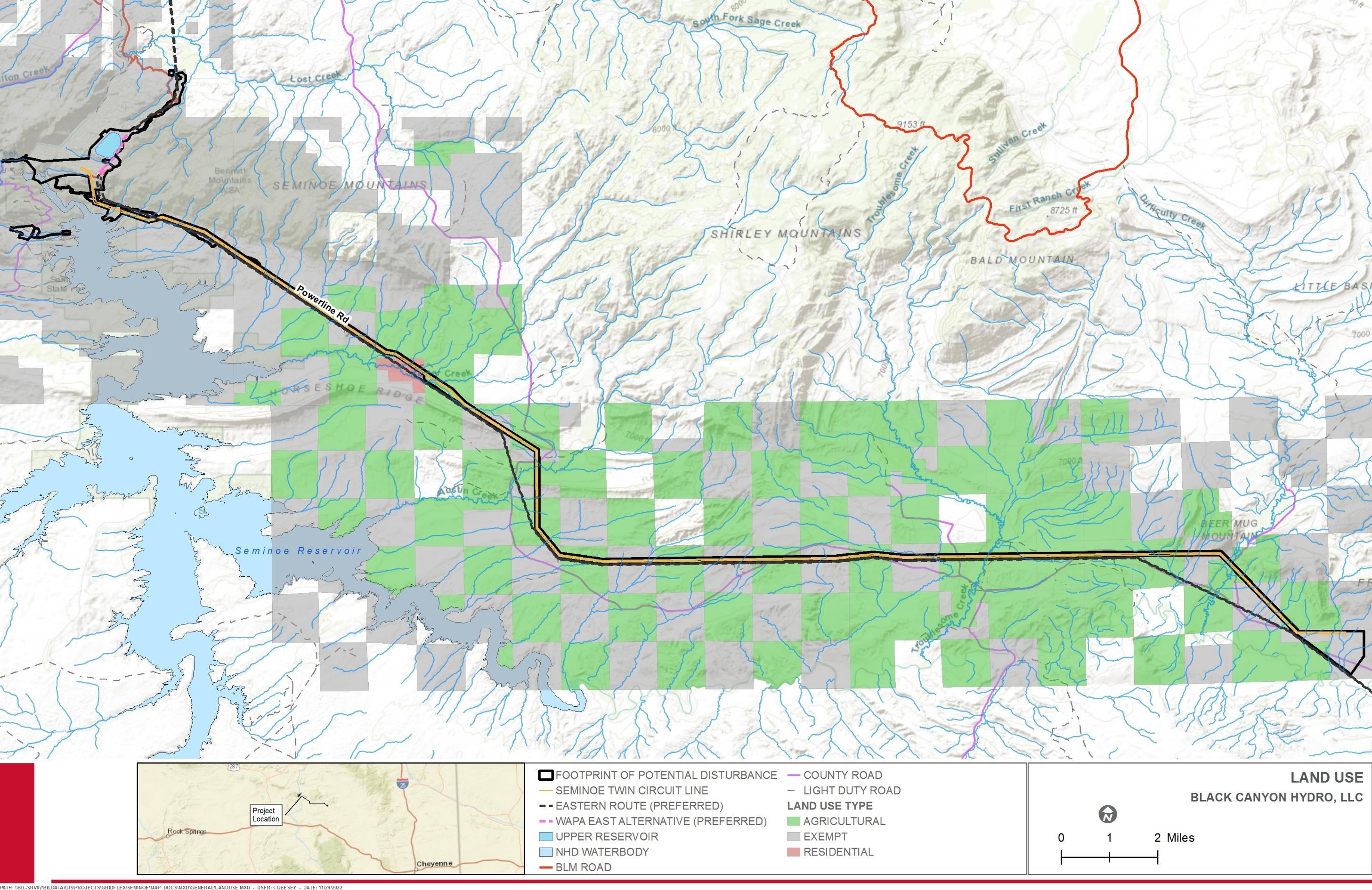
Figure 3.9-1. Land Use in the Project Vicinity
This page intentionally left blank.
Section 102 of the Federal Land Policy and Management Act directs the BLM to prepare land use plans that serve as the basis for all activities that occur on BLM-administered lands. The applicable land use plan in the vicinity of the Project is the Rawlins Record of Decision and Approved Resource Management Plan (RMP) (BLM 2008b). The RMP provides direction for management of renewable and nonrenewable resources found on public lands within the Rawlins Field Office (RFO) planning area and guides decisionmaking for future site-specific actions. The Approved RMP directs the RFO in resource management activities including leasing minerals such as oil and gas; construction of electrical transmission lines, gas pipelines, and roads; grazing management; recreation and outfitting; preserving and restoring wildlife habitat; selling or exchanging lands for the benefit of local communities; military use of the planning area; and conducting other activities that require land use planning decisions. The RFO Approved RMP covers approximately 11.2 million acres of public land in Albany, Carbon, Laramie, and Sweetwater Counties in Wyoming (BLM 2008b).
Carbon County abides by a Comprehensive Land Use Plan that focuses on unincorporated areas of the County as well as the City of Rawlins and incorporated towns (Carbon County Board of Commissioners 2012). The County’s Land Use Plan defines the goals and strategies for future land uses in Carbon County in order to support sustainable growth and attain local values. Seven major goals are outlined in the plan, including the following:
1. Achieve a sustainable balance between energy development, agriculture, and the environment. 2. Protect water supplies of established users. 3. Sustain scenic areas, wildlife habitat, and other important open spaces. 4. Retain ranching and agriculture as the preferred land uses in rural areas. 5. Locate new residential developments and commercial sites near municipalities and developed areas. 6. Ensure that future land development is fiscally responsible and has adequate roads and other infrastructure. 7. Retain diversity of use on public lands and provide for conversion of public lands to other land uses as would benefit the orderly development of the County.
All non-federal lands in the Project vicinity are zoned by Carbon County for Ranching, Agriculture, and Mining (RAM) (Carbon County Planning and Zoning Commission 2015; Carbon County Department of Planning and Development 2017). The purpose of the RAM zoning district is “to preserve historic uses and open space areas of the County while at the same time permit ranching, agriculture, animal husbandry, forestry, and mining in a manner that attains this purpose.
Carbon County also recently developed a Natural Resource Management Plan (NRMP) that addresses land uses in the County (Carbon County Board of Commissioners 2021). The Carbon County NRMP serves as a basis for coordinating with federal and state agencies on land and resource management in the County. The County is split into three soil conservation districts in which the Project is located within the Medicine Bow Conservation District in the northeastern third of the County. The NRMP discusses the history, custom, and culture of various natural and socioeconomic resources in the County,
then describes resource management objectives for each. The resource management objectives for general land use in the County’s NRMP include the following:
1. The basis for management of all public lands within Carbon County is multiple-use management. 2. Federal agencies consider the direct and indirect effects on private and state lands on a local region-wide basis rather than only analyzing the impacts on federal lands. 3. Federal agency decisions on federal public lands minimally impact neighboring state and private lands. 4. Federal land-use projects in mixed land ownership areas are coordinated with
Carbon County and rely heavily on input from neighboring private landowners. 5. Effective reclamation plans that protect existing uses are a primary requisite when approving projects in mixed land ownership projects.
The Carbon County NRMP also includes management objectives for renewable energy (including hydropower) development in that development should strive for sustainable balance between energy and other resources (Carbon County Board of Commissioners 2021).
3.9.1.1 Vegetation and Wildlife Habitat
According to the USGS Gap Analysis Program (GAP)/LANDFIRE National Terrestrial Ecosystems dataset (USGS 2011) there are 16 landcover types present within the Footprint of Potential Disturbance (Table 3.9-2). USGS landcover mapping shows that the vegetation types in the boundary are relatively low in complexity, with two cover types comprising 70 percent of the Footprint of Potential Disturbance (Inter-Mountain Basins Big Sagebrush Steppe and Inter-Mountain Basins Mixed Salt Desert Scrub). Details on these landcover types and a comparison to landcover types mapped at the Project in 2021 and 2022 is provided in Appendix G. Vegetation and habitat mapping of the botanical study area was performed as part of the Habitat Assessment and RTE Species Evaluation Study (Appendix G) and is discussed further in Sections 3.6 Botanical Resources and 3.7 Wildlife Resources. Landcover in the Footprint of Potential Disturbance is consistent with rolling sagebrush steppe, foothill shrubland, and low mountains of the intermountain west and Wyoming basin.
Table 3.9-2. Verified Land Cover Types Within the Botanical Study Area1
Landcover Types
Inter-Mountain Basins Big Sagebrush Steppe
Acres Percent of Study Area
909.3 57
Inter-Mountain Basins Mixed Salt Desert Scrub 309.3 19
Wyoming Basins Dwarf Sagebrush Shrubland and Steppe 142.2 9
Rocky Mountain Foothill Limber Pine – Juniper Woodland 139.9 9 Inter-Mountain Basins Greasewood Flat 28.5 2
Landcover Types
Acres Percent of Study Area
Inter-Mountain Basins Mat Saltbush Shrubland 25.7 2 Western Great Plains Riparian Woodland and Shrubland 14.3 1 Western Great Plains Cliff and Outcrop 8.8 1 Western Great Plains Saline Depression Wetland 6.0 <1 Inter-Mountain Basins Cliff and Canyon 5.6 <1 Open Water (Fresh) 3.7 <1 Inter-Mountain Basins Big Sagebrush Shrubland 2.4 <1 Northwestern Great Plains Mixedgrass Prairie 1.9 <1 Western Great Plains Open Freshwater Depression Wetland 0.5 <1 Inter-Mountain Basins Shale Badland 0.3 <1 Inter-Mountain Basins CurlWoodland and Shrubland leaf Mountain Mahogany 0.2 <1
Total 1,598.5
Source: USGS 2011. 1 The botanical study area is defined in Section 3.6 and includes all lands that may be affected by Project construction and operation. 3.9.1.2 Floodplains and Wetlands
According to the Federal Emergency Management Agency (FEMA) National Flood Hazard Layer and map viewer, there are no floodplains in the vicinity of the Project (FEMA 2021).
Waterbodies, riparian corridors, and wetlands are relatively rare in the study area. Wetlands are discussed in Section 3.4 Water Resources.
3.9.1.3 Grazing
Congress mandates that BLM manage grazing, and BLM livestock grazing policies are designed to protect the productivity of public lands in an efficient and effective manner. There are a total of 582 grazing allotments within the BLM Rawlins RMPPA totaling 3,492,744 acres (BLM 2008a). The BLM defines grazing systems in the following seven categories:
• Permit Long. Grazing occurs for part of or for the duration of the permitted time, often lasting from late spring through fall. • Year-Long Permit. Grazing is permitted for any time during the year. • Rotation. Grazing is rotated during the growing season between pastures in the allotment to provide partial growing season rest before use or recovery time after use. • Deferred Rotation. Grazing is rotated between pastures or allotments to provide full growing season rest every second or third year. • Dormant Season. Grazing occurs after seed-set by grasses; includes late summer, fall, and/or winter grazing.
• Split Season. Grazing occurs during two separate time periods, by removing livestock from the allotment and returning them later in the year to provide partial growing season rest. • Rest Rotation. Grazing is rotated between pastures, with each pasture receiving no grazing use for an entire year, usually every third or fourth year.
The utilization of public lands for grazing as managed by the BLM provides for efficient, sustainable, and economical production of livestock (Carbon County Board of Commissioners 2021). Permitted grazing on public lands is a critical component of livestock operations in Carbon County. All the BLM-managed lands within the Footprint of Potential Disturbance are managed under grazing allotments (BLM 2008a). Twelve grazing allotments over 385,300 total acres with a total of 24,454 federal animal unit months (AUMs) are partially occupied by the Footprint of Potential Disturbance (Table 3.9-3, BLM 2008a). The Footprint of Potential Disturbance will occupy less than 8 percent of any one grazing allotment. In particular, the percent of allotment within the Footprint of Potential Disturbance is 3.9 percent for the Black Canyon allotment and only 1.2 percent of the allotment is located within the FERC Project Boundary. The percent of allotment within the Footprint of Potential Disturbance for Seminoe allotment is less than 1 percent and this allotment does not overlap with the FERC Project Boundary. The ROW will remain active for grazing upon construction completion and, therefore, impacts to the grazing allotments will be reduced.
3.9.1.4 Agricultural Lands
Agriculture plays a significant role in the economy of Carbon County, as it does across the State of Wyoming (Carbon County Board of Commissioners 2012). Carbon County is a top producer of cattle in the state, with secondary products such as hay production. Other crops are not generally produced in the County. A total of 1,324 agricultural parcels comprising nearly two million acres of land exist in Carbon County (92.9 percent of land in the County). Agricultural parcels in the Project vicinity are large, with some 632 to 2,188 acres, but most are larger.


