2 minute read
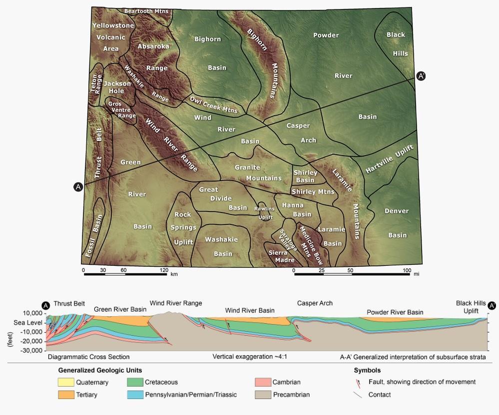
Figure 3.3-1. Major Mountain Ranges and Basins in the State of Wyoming with Geological Cross-Section


Final License Application – Exhibit E Seminoe Pumped Storage Project
Source: Chapman et al. 2004.
Figure 3.3-1. Major Mountain Ranges and Basins in the State of Wyoming with Geological Cross-Section
January 2023 | 88
Carbon County is dominated by six geologic structural basins (Hanna, Great Divide, Washakie, Kindt, Laramie, and Shirley basins) and by five major uplift features (Rawlins Uplift, Sweetwater Arch (including the Ferris and Seminoe Mountains), Shirley-Freezeout Mountains, Medicine Bow Mountains, and Sierra Madre). Carbon County is topographically dominated by the Medicine Bow Mountains and Sierra Madre in the southern part of the county; however, the remaining areas of the county also have substantial local relief because of smaller mountains such as the Ferris, Seminoe, and Shirley Mountains, as well as numerous ridges and scarps. The county includes part or all of several topographic and structural basins, including all of the Saratoga Valley, the Kindt, Hanna, and Shirley Basins as well as parts of the Laramie and Great Divide Basins (Bartos et al. 2006) (Figure 3.3-2).
Key mountain-building events that affected the region include the Sevier Orogeny and the Laramide Orogeny. The Sevier Orogeny occurred during the Jurassic to Eocene (140-50 million years) when the oceanic plate to the west subducted under North America near present-day California, resulting in compressive stresses (due to collision), crustal thickening, and mountain building. These tectonic forces resulted in north-south trending mountain ranges in Wyoming (e.g., the Thrust Belt). Dominant structures that formed as a result of the Sevier Orogeny include west-dipping, east-vergent thrust faults that displace sedimentary rocks above the crystalline basement rocks (i.e., they do not displace basement rocks) (Black Canyon 2020b).
The Laramide orogeny occurred from approximately 70 to 35 million years ago, originating from the same horizontal compression that defined the previous Sevier Orogeny (i.e., subduction of the oceanic plate underneath the continental crust in the west). Structures resulting from this orogeny differ from the structures produced during the Sevier Orogeny as the Laramide faults displace crystalline basement rocks as well as the overlying sedimentary rocks (Wyoming State Geological Survey [WSGS] 2020).
Rocks ranging from Precambrian (2.7 billion years) to Quaternary age are present within the Project vicinity, except for the Ordovician, Silurian, and Devonian representatives. The oldest lithologies consist of crystalline basement rock which intruded sediments up to 25,000 feet thick associated with the Beltian Geosyncline over several separate geologic events (Bennett and Aalto 1982).
Between early-Oligocene and middle-Pliocene, tremendous amounts of tuffaceous material were extruded from western provinces (notably the present-day Yellowstone National Park region), resulting in surface layers at least several hundred feet thick throughout Carbon County. Much of this deposited material was removed due to latePliocene uplift, which, coupled with quiescence of volcanism, allowed for rapid excavation during the Pleistocene so that now, in many cases, high-level remnants are the only reminders of what had once been an almost continuous blanket of volcanic fall-out debris. The closest intrusive rocks of Tertiary age are approximately 40 miles northwest of Seminoe Dam in the Rattlesnake Range (Bennett and Aalto 1982).


