
4 minute read
Andrew Hobbs

During the first months of the pandemic, we only walked from our house, not using our cars to travel any distance. Very quickly I began to compare this experience to those who lived in the area in previous centuries when most people had no other transport. We are very fortunate to live in a rural area that has changed very little for centuries with very little new building and most of that being part of existing farmsteads. The area is called Roughbirchworth and today is part of the parish of Oxspring in the Metropolitan Borough of Barnsley. It is an ancient agricultural area, mentioned in the Domesday Book, that has remained a collection of a small number of farmsteads. The village and amenities are in Oxspring in the valley.
Walking daily across the fields provided the opportunity to look carefully at the landscape and its defining characteristics, which I photographed almost every day. I also began to research the history and to reflect on the lives of those who have lived and worked in the area to develop its characteristics. The 1893 OS Map of the area clearly identifies some of the main features of the landscape, especially the pathways and the boundaries of the fields, that maintain to this day the outline of the medieval strip system of farming. The names of various features and routes also have historic relationships to activities or places. For example, there was an iron age fort (marked on the OS Map as a ‘Camp’,) that later became the site of a Roman Fort and the origins of the name ‘Castle’ to be found in the area. Some of the farmsteads and farm buildings are now converted to housing, but retain the ancient names and characteristics. Farming practices have changed but the types of farming continues to be a mixture of dairy, sheep and arable.
The images selected, of the many taken during 2020, are intended to present an introduction to the main characteristics of the area of Roughbirchworth and the history that remains visible today. All but two of the images are in monochrome to reflect the historic origins of the subject. The two exceptions are the first and final main photographs that show the landscape from different viewpoints and in different seasons.
The first landscapes show views of the fields of Roughbirchworth from which it is possible to see the long, narrow fields that can be traced back to the medieval strip system. The photographs were taken from the other side of the valley, looking across part of Oxspring. The two images overlap helping to show the length of the fields, as well as the hill behind. The final image looks in an easterly direction, across part of the fields still identified as ‘Roughbirchworth Common’ towards the Blackmoor Farmsteads.
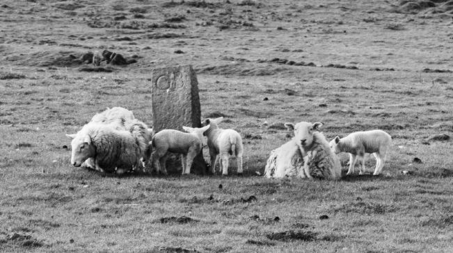
The ‘guide stoop’ (on this page) was erected in 1734 and is a hexagonal stone signpost that shows how Roughbirchworth was once the junction for several ancient routes connecting the east and west of England. The photograph with the sheep shows a remaining boundary stone, erected in 1756, when a long dispute over the boundary between the Oxspring and Hunshelf parishes was settled. The initials GB stand for Godfrey Bosville and his descendants, who were Lords of the Manor of Oxspring and other parishes in the area for several centuries.
The images of the gateposts and stone walls are a defining feature of the area. There is a wide variety of gateposts, some being large slabs of rock moved into position, whilst others have been shaped and decorated to give status to entrance ways. The damage to some of the posts illustrated, suggests that they may have been moved to their current position. It is possible to gain some indication of when a stone wall was erected from the stones used and how it was constructed. A farmer also said that it is possible to identify the builder of later walls from signature features of the construction. The packhorse bridge was on the ancient route that linked the east and west of the country that was an important salt route from the Cheshire salt mines. The present Willow Bridge structure dates from around 1734.
Finally, as an interesting footnote in the year of the global pandemic of Covid 19, Roughbirchworth was the site of a Smallpox Isolation Hospital, built in 1896 because of an epidemic in the area. It existed until the early 1960’s used in later years for scarlet fever.

Guide Stoop Gatepost Hole

Roughbirchworth Field System


Boundary Stone


Willow Bridge

Autumn Dawn
