ANNUAL REVIEW 2025
HERITAGE PHOTOGRAPHY
CONTENTS EDITORIAL HERITAGE PHOTOGRAPHY Journal of the Archaeology and Heritage Special Interest Group
3 Perspective:Annual Review 2025 DAVID BRYSON FRPS
4
Thoughts from the Chair SHAUN PARKES ARPS
June 2026
PHOTOGRAPHS
Editor David Bryson FRPS heritage.editor@rps.org
Facebook Favourites MEMBERS PHOTOGRAPHS
Archaeology & Heritage Group Committee Members
FEATURES
Chair Shaun Parkes MA ARPS LDPS heritagechair@rps.org Heritage Photography Editor David Bryson FRPS heritage.editor@rps.org Secretary Amanda Miller LRPS heritagesec@rps.org
5-6
7-19 Varieties of digital
imaging to support community archaeology DAVID BROWNRIGG
20-28 Helping to look after Cornish heritage. ALAN BURCHELL
Finance Officer David Bryson FRPS heritagetreasurer@rps.org
29-36 The splendour of
Communications Officer Vacancy
EDMUND WHITE
Military Heritage and Distribution Shaun Parkes MA ARPS LDPS heritagemilitary@rps.org
Limousin
International Representative Joseph Durocher heritage.international@rps.org
46-59 West Norwood Cemetery and Catacombs
Published by the Archaeology and Heritage Special Interest Group of the Royal Photographic Society, January 2026 Copyright in all text and photographs are held by the credited authors, or as otherwise stated. No part of this publication may be reproduced, transmitted or stored in any form without prior written permission of the Publisher.
7
a floor: St George’s Hall, Liverpool
29
37-45 Dolmens in the GARY DAVIS
EDMUND WHITE
60-64 Carved Memory: The artisanal façades of Saint Henri JOSEPH DUROCHER
37
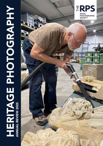
Print ISSN 0958-0565 Online ISSN 2632-3346 Front cover: One of our members Alan Burchell hard at work read more about his work with heritage.
46
2
EDITORIAL
Perspective: Annual Review for 2025 DAVID BRYSON FRPS
Carving from Borobudor temple on Java of an elephant a reminder that “an elephant never forgets” David Bryson FRPS
W
elcome to the annual review issue covering a selection of features and photographs from the 2025 issues of Heritage Photography. Thanks to members and guest we have an eclectic range of features from our digital issues published in 2025. Starting with an archaeological piece using photography and 3-D imaging techniques from David Brownrigg, then a look at the work of Alan Burchell with cornish heritage sites, then an amazing look at the floor of St George’s Hall in Liverpool normally covered over, as seen in the banquet of the Great British menu, following we have the prehistoric remains from Limousin from Gary Davis, then the slightly macabre but fascinating catacombs from Edmund White and finally the artisanal facades of Saint Henri in Canada from the international representative on our committee Joseph Durocher.
If you want feedback on any ideas you have please e-mail me at heritage.editor@rps.org Please remember there is always a need for great portrait photographs to grace our front covers. In fact portrait photographs are also easier to give a full A4 page to inside issues whereas landscapes tend to get relegated to half an A4 page. Putting a landscape across a double page spread looks fine when printed but not so great digitally as they are seen as half a photograph as you flick through an issue’s pages and double page spreads can be difficult to manage when laying out the pages of an issue.
Can I please as usual ask for more submissions for the journal there are plenty of examples of what to submit on the RPS issuu site in our stack at https://issuu.com/royalphotographicsociety/stacks/ e5208ecd8f7d49a7b1a1ef0043524256. 3
EDITORIAL
Thoughts from the Chair SHAUN PARKES MA ARPS LDPS
Local opera performance, Ningbo, China. S Parkes 14 Apr 2026.
I
am very pleased to commend to you our first annual hard-copy annual edition of Heritage Photography (HP); it contains very interesting articles on a variety of topics. Last year, the Committee reluctantly had to take the hard decision to move to a mainly digital distribution model for HP, primarily due to the increasing postage costs. It is our intention to include in the annual edition, some of the articles featured in the previous year’s digital editions, and some of the competition winning entries too. Therefore, if you aspire to see your photography in hard copy, it is very important that you contribute to HP to get your article and photographs in the digital editions. We need a continual flow of articles to populate the journal, and most people should be able to generate an article on their local area. As I have said before, you don’t need to be a fluent writer; if you need help with writing, I am more than happy to help you write the article. Please contact the editor, David, at heritage. editor@rps.org if you want to discuss ideas and
4
copy requirements. As you may recall I spent two months in China, where they place great emphasis on cultural heritage, and archaeological digs are constantly being undertaken. Just as we in the western hemisphere place great importance on our seats of religion, education and government, so do the Chinese, where ancient towns are preserved; often within the boundaries of the modern, expanded towns, so it is not uncommon to find historically important buildings amongst residential and commercial properties. The Chinese also take great pride in their cultural and artistic heritage, and my wife and I were invited to attend a night at the local operatic society. The sets, the costumery, and the dramatic performance were all quite superb. Shaun Parkes ARPS
FACEBOOK FAVOURITES
March 2025: Memorials
Volunteers in Calgary place crosses, flags, and candles, along Memorial Drive to commemorate family members from the area who served and gave their lives. Photograph: Ted Burchnall.
April 2025: Transport Heritage
Ship carving from Borobudur Temple, Java. David Bryson FRPS
5
FACEBOOK FAVOURITES
November 2025: Remembrance
This from a local church St John the Baptist in Kingston Vale. This a fine, small Victorian church very much in the Victorian Gothic style, where I help with photography for their website. Photograph: Edmund White
December: Festivities
Russia, the city of Moscow. On Pushkin Square. Fountain of illuminations. The evening before New Year’s Eve in December. Photograph: Sergei Shchekotov-Aleksandrov
6
GUEST FEATURE
Varieties of digital imaging to support community archaeology This work has developed from my long-standing interests in archaeology and remote sensing, and evolved through a developing interest in aerial imaging. DAVID BROWNRIGG Introduction Kent Archaeological Society (KAS) is the representative society in the county with staff covering professional and public outreach functions. I have carried out several aerial digital imaging surveys at some KAS excavations, applying aspects of my image processing background that ranges from astronomy to computer art [BRO84, BRO18]. While aerial photography began with analogue forms, digital imaging is now intrinsic to generating useful results. The reasons for this include utilising the numerical values representing pixels to relate multiple images through software to derive threedimensional models of the landscape in various spectral bands. While a wide range of aerial imaging forms are of value in archaeology, those illustrated here are limited to visible wavelengths, using a DJI Mini 3 Pro drone with 48MPix still and 4K video capability, and illustrated in the top-right inset of Figure 1.
Background to Aerial Imaging Photography from the air has been of interest since the early days of the medium, more than a century before the advent of digital imaging. The development has followed the availability of camera carrying vehicles and the uses of aerial image making. The earliest such photographs were from a balloon over Paris in 1858 [NAD58] with the first balloon-born camera use in the UK being over Stonehenge in 1906 [ROE06]. Those events showed already the extension of interest from commercial to military, for which intelligence interests also drove the development of more sophisticated vehicles. Cameras carried by balloons, pigeons, kites, manned aircraft, rockets, and satellites have been used variously for military, commercial and scientific applications. Digital imaging, with the facilities for integrating different image types
and sources, now enables a burgeoning range of applications. Intrinsic to this is the use of facilities such as QGIS [QGI] that includes contour facilities and layering existing images with new, as well as handling image dimensions beyond the 30K limit in linear size that still is common in much photoprocessing software.
Some Varieties of Aerial Imaging for Archaeology In discovery of UK archaeological sites, the work of OGS Crawford [CRA29] was very significant in the early 20th century. In particular, low angle lighting is effective in revealing small ground elevation variation. Another important technique arises from extending the camera spectral range, as functions of visible spectral bands and infrared are effective in showing up differences in vegetation development. While this has many uses in agriculture, another is in helping see effects arising from variations in subsurface conditions. For example, poorer vegetation growth will occur over a dry substratum, such as the remains of ancient building foundations, while growth may be enhanced where soil fill, over an ancient ditch feature, enhances moisture retention. An important development has been in LiDAR (Light Detection And Ranging), that can provide not only centimetre level of accuracy in elevation measurement but also enable penetration to ground level through cover such as tree foliage, by discriminating between multiple reflections back from the on-board light source. All these methods can be valuable in identifying previously unknown archaeological features, including for sites under excavation. Many requirements can be covered with image capture in the visible spectrum, and it is some of these that I shall be looking at, particularly where the use of a small drone is helpful.
7
Figure 1. Top-right inset shows the drone used: a DJI Mini 3 Pro, upper shows a sample oblique site view, and lower shows a sample vertical site view.
8
Forms of Image Used Here Firstly, single images of an excavation may be needed by an archaeologist to review progress and in helping plan future action. Such images may be with the camera oblique as in Figure 1 upper, for which close approach to people is permitted with a lightweight drone. An alternative view is vertical (normal) in relation to the ground, as in Figure 1 lower, showing an early stage of the excavation. This view does not provide an orthonormal, standard map view (every point in the image viewed as though from vertically above) even from an altitude of over 300 feet, as can be seen where the base of the yellow arrow is directly below the camera but the head of the arrow points to the sides of the site hut and work tent. A benefit of operating at lower altitude is that images have much higher resolution than provided by generally available satellite images. Figure 2 top shows a typical programmed flight pattern, at below 10 metres altitude, using Dronelink [DRO], and includes a low-resolution satellite image as a background, illustrating the need for more detailed imaging. Figure 2 centre shows the camera positions from a typical survey, and bottom shows an alternative set of camera positions in gathering images in a circle at four heights between 4 and 25 metres, overlaid on a 3D view generated by AliceVision’s Meshroom [MES]. However, a common requirement for a dig image is to appear as a standard map or orthonormal view, and any one drone image does not provide this except for the point directly below the vertical (or normal) camera. Software such as OpenDroneMap [ODM] can be used to process multiple overlapping images to compute a detailed digital map where the 3D position for each pixel corresponds to a ground point. This enables viewing of the calculated surface with interactive perspective or as a 2D standard map view, which can be overlaid or combined with other map data, with elevation data for each map point. The detailed 2D map can be used both for an overall view and for local detail inspection by zooming in on the image, which can give millimetrelevel detail across a site of many tens of metres. Figure 3 upper shows nine sample survey images, each original of 4032x3024 pixels, around a pit feature while the lower shows the part of the computed orthonormal map that corresponds to the region around the pit. The resolution, of 2mm/ pixel, is carried over from the full set of about 200 overlapping, original images to the site map of over 24000x21000 pixels. Also important for archaeological dig records is how an excavation progresses and regular, repeated site surveys allow such changes to be monitored. This is aided by drones and associated software that allow a survey pattern for image collection to be repeated consistently. The set of site surveys not only enables detailed inspection and comparison but also allows the generation of
an animation by interpolation between successive orthonormal maps, valuable in seeing how dig activity developed by location within the site over the excavation period. In addition, direct video is a useful archaeological record, and hyperlapse imaging, such as over multiple height circular paths, also can be used for construction of interactive 3D views, using software such as ODM and MES.
Examples of generated images. Here I look at a sample of the possible image forms for archaeology, illustrating work by the Kent Archaeological Society in 2024 on a Neolithic ring ditch site south of Faversham in Kent. Information on this is in a KAS report by Parfitt and Taylor [PT2024]. Figure 4 shows part of the ODM-generated orthonormal view at 2mm/pixel with a reference low-resolution satellite image background. The detail is such that a print of the map at 300dpi would be nearly 7 feet wide. As usual, informed reading is needed for interpretation as exemplified by the half dozen roughly circular grey areas showing in the chalk-based surface which are natural formations and not of human origin. Figure 5 is a corresponding view, colour coded, of the elevation data. Many standard aerial photographs are taken near dawn or sunset as the low angle light emphasises features by casting shadows, and this is simulated by ODM, emphasising low-relief features such as the two post holes near the image centre. Figure 6 shows examples of ODM 3D perspective oblique views of the excavation surface in the area of the curved pit on the west side of the site. The upper image is from above ground, looking southeast, while the lower image shows how appreciation of the pit feature shape can be enhanced by viewing from below, here looking north-west. The 2D standard map view is valuable for record, interactive viewing at different scales, and publication. The view can be enriched by encoding the elevation information via contour lines, and the level of detail can be adjusted to image feature scale. QGIS provides for flexibility in control and representation of contours and allows variable opacity of the orthonormal map layer, here with a satellite-view background. I set opacity to 100% in Figure 7 upper and 50% in Figure 7 lower and in Figure 8. As an overview, Figure 7 upper shows the whole site with contours at 25 cm interval, while Figure 7 lower shows the western curved pit, with 5 cm interval contours, emphasised every 25 cm. The contours highlight the segmented form of the ring ditch, characteristic of Neolithic forms. Lastly Figure 8 shows an even finer level of detail for the southern end of the western pit, with contours at 1 cm interval and those at 5 cm interval emphasised and labelled.
9
Figure 2. Top shows a typical programmed flight pattern, at below 10 metres altitude, using Dronelink [DRO], Centre shows the camera positions from a typical survey, and bottom shows an alternative set of camera positions in gathering images in a circle at four heights between 4 and 25 metres
10
Figure 3. Upper shows nine sample survey images, each original of 4032x3024 pixels, around a pit feature while the lower shows the part of the computed orthonormal map that corresponds to the region around the pit. The resolution, of 2mm/pixel, is carried over from the original images to the map of over 24000x21000 pixels.
11
Figure 4. Shows part of the ODM-generated orthonormal view at 2mm/pixel with a reference low-resolution satellite image background. The detail is such that a print of the map at 300dpi would be nearly 7 feet wide.
12
13
Figure 5. Is a corresponding view, colour coded, of the elevation data. Many standard aerial photographs are taken near dawn or sunset as the low angle light which emphasises features by casting shadows, and this is simulated by ODM, emphasising lowrelief features such as the two post holes near the image centre.
14
15
Figure 6. Shows examples of ODM 3D perspective oblique views of the excavation surface in the area of the curved pit on the west of the site. The top image is from above ground while the bottom image shows how appreciation of the pit feature shape can be enhanced by viewing from below.
16
Figure 7. Top shows the whole site with contours at 25 cm interval, while Figure 7 bottom shows the curved pit to the west, with 5 cm interval contours, emphasised and labelled every 25 cm. The contours highlight the segmented form of the ring ditch, characteristic of Neolithic forms.
17
Figure 8. Shows an even finer level of detail for the lower end of the left pit, with contours at 1 cm interval and those at 5 cm interval emphasised and labelled
18
Archaeological imaging is an ever-expanding field, and I recommend looking at current developments by following specialist organisations such as the Aerial Archaeology Research Group [AARG].
References AARG: https://aargonline.com/wp/ BRO84: Brownrigg, D.R.K.; The Weighted Median Filter; Comm.A.C.M. 27, No.8, pp807-818, (1984) BRO18: Brownrigg, D.R.K.; Image Creation Through Manipulation of Transform Space Representations; Leonardo, Vol.51, No.3, pp251-257, (2018) CRA29: Crawford, O.G.S.; Air Photography for Archaeologists (Ordnance Survey Professional Papers New Series, No. 12), (1929) DRO:
https://www.dronelink.com/
MES:
https://alicevision.org/
NAD58: e.g. https://commons.wikimedia.org/wiki/File:Nadar_place_de_letoile_1858.jpg ODM: https://www.opendronemap.org/webodm/ PT2024: https://www.kentarchaeology.org.uk/magazine/122/11-further-excavations-around-stringmansfarm-2024 QGI:
https://qgis.org/
ROE06: e.g. https://upload.wikimedia.org/wikipedia/commons/a/ab/Stonehenge_from_the_air_-_Philip_ Henry_Sharpe_%28Royal_Engineers%29_-_1906.jpg
19
FEATURE
Helping to look after Cornish Heritage. I have been a member of English Heritage for a number of years. I obtained a bachelors and masters degrees in archaeology from Exeter University as a mature student following my career in the military and police, About four years ago I started to volunteer as a Free Sites Monitor, a photographic volunteer and recently a volunteer conservator at the English Heritage archives in Somerset and at Pendennis Castle, Falmouth. ALAN BURCHELL
L
iving in Cornwall I am surrounded by archaeology, from the Palaeolithic to the mining industry. As an English Heritage free sites monitor, I have responsibility to check and report back on the condition of seven sites, from a standing stone to a castle.
The sites monitored: 1.
Dupath Well
2. The Hurlers Stone Circles 3. Trethevy Quoit 4. King Doniert’s Stone 5. St Catharine’s Castle 6. St Breock Downs Monolith 7.
Locations of the seven monitored sites in Cornwall.
20
Penhallam Manor
1. Dupath Well - Chapel-like well-house built about 1500 by the canons of nearby St. Germans Priory. Inside the water flows from a spring into a sunken basin. It was believed to cure whooping cough and may have also been used for baptisms. There are around 40 Cornish holy wells with a building over them.
21
2. The Hurlers Stone Circles - Three late Neolithic or early Bronze Age stone circles with regularly shaped stones: they are arranged in a line, which is very rare in England. They also align with other prehistoric monuments in the Bodmin Moor ritual landscape. According to medieval legend, these stones are local men who were turned to stone for playing the Cornish game of hurling on a Sunday.
22
3. Trethevy Quoit - An impressive Neolithic ‘portal dolman’ standing 2.7 metres high. It’s the finest example of this distinctively Cornish type of monument. Five standing stones support a huge and now tilted capstone, weighing around 20 tonnes. The stone chamber was originally covered by an earth mound.
23
4.King Doniert’s Stone - Two richly carved pieces of 9th-century crosses, and the only surviving examples of their kind in Cornwall. One has an inscription commemorating Doniert, also known as Dungarth, the very last recorded ruler of the British kingdom of Cornwall. He was drowned in about AD 875, allegedly as a punishment for plotting with the Vikings.
24
5. St Catharine’s Castle, Fowey - Spectacularly perched on a rocky headland and only accessible on foot. St Catharine’s Castle is one of two small artillery forts built by Henry VIII to guard the entrance to Fowey Harbour. It has two rows of gunports covering both the approach and the harbour itself. The site was given new artillery during the Crimean War, and housed an anti-aircraft gun in 1940.
25
6.St. Breock Downs Monolith - Cornwall’s largest prehistoric standing stone, weighing nearly 17 tonnes and now leaning, standing 3 metres high. It’s near the summit of the St. Breock Downs, with beautiful views across the countryside to the sea. Famous in local folklore as a medieval and later meeting place.
26
7. Penhallam Manor - built in the 13th century by Andrew de Cardinham, only the stub walls mark the complete ground-plan of this historic moated manor house.. Most commonly found in central and eastern England, moated manor houses are rarely seen in the south-west , making Penhallam an unusual find. Its remains were excavated and consolidated in 1968 - 73. The site is now a peaceful nature reserve in a wooded area.
27
Conservation at the English Heritage archives, here I am, cleaning stone sculptures from one of the many sites under English Heritage’s governance. As a conservation volunteer. The second photo shows the checking of one of the many canon and military ordnance held at Pendennis Castle. As a volunteer for English Heritage, I have found the experience very rewarding, learning new skills, meeting new people and being able to use my archaeology knowledge to gain insight into fascinating areas I would not normally be able to access.
28
References English Heritage Hand Book 2025-27 Cornwall Heritage Trust website https://www. cornwallheritagetrust.org All photographs by Alan Burchell
ALAN BURCHELL BA (HONS), MA.
FEATURE
The splendour of a floor: St George’s Hall, Liverpool. St George’s Hall, Liverpool, constructed between 1841 and 1854, was intended as a multipurpose building for public gatherings, concerts, and legal proceedings. Its grand design was the work of Harvey Lonsdale Elmes, a young architect who at the age of just 25, won a competition to design the hall. Sadly, Elmes did not live to see its completion, as he died of tuberculosis in 1847 in Jamaica, aged only 33. EDMUND WHITE
First look at the stunning floor.
29
First look in close-up
I
was born and brought up in Birkdale, further up the coast. The dark bulk of the hall has featured long in my memory as it is almost opposite Lime Street Station in Liverpool, my railway gateway to London, student adventures and life in general. Although it is considered one of the finest examples of neoclassical architecture in Europe, I’d never given the brooding, soot-blackened edifice a second thought. Roll the clock forward thirty plus years to 2013 when I was visiting my mother, who still lived in Birkdale. I was heading back to the local station for a train to Liverpool to take me home to Surrey, when my mother simply commented that “if the hall is open, you should pop in, it’s worth a look”. I took an earlier train – just in case. The hall was open – and not busy – so I went in and was stunned by a floor unlike any I had seen before. Completed in 1854, the huge floor was designed by the renowned Minton Tile Company, famed for their vibrant, durable, and exquisitely patterned encaustic tiles. The floor area comprises approximately 30,000 individual tiles, each crafted with meticulous detail. The pattern is a mixture of intricate geometric designs, floral motifs, and symbolic emblems, including representations of Liverpool’s maritime heritage, such as the Liver bird.
30
At this point I realised this was a unique opportunity. The floor is only infrequently uncovered – or ‘revealed’ in local parlance. How the floor is revealed https://www.facebook.com/ share/v/1LxH7qpDy7/ I needed to take some photographs! I’d travelled north with minimal luggage, which included minimal camera kit. I’d been experimenting with various ‘artistic’ techniques, and although I had a good DSLR with me, I had only a vintage wide-angle lens and a Lensbaby Double Glass optic. Talk about being “under-lensed” for the occasion. I managed to capture several useful images, including some from a brief exposition on Milton tiles. The few stained-glass windows and imposing organ are lost against the spectacular floor. I later discovered that this was only the second time the fully restored floor had been shown to the public since the second World War. I also discovered that my mother had seen it the previous year when it was first ‘revealed’ in all its glory – hence her recommendation. I’m told that ‘reveals’, when they happen, now attract thousands of visitors, making capturing good images difficult.
Although stopped down the Lensbaby DGO is sur-
Close up of the Minton encaustic tiles
31
32
The organ and stained glass windows with the Liver bird in the centre.
Emblems in tiles top fish marking maritime history and below Liverpool’s coat of arms.
33
St George and the dragon in stained glass.
34
35
Individual encaustic tiles and their precursors embossed in white.
prisingly sharp, I’ve learnt to always carry one good, ‘normal’ lens, no matter what other kit I have with me!
36
GUEST FEATURE
Dolmens in the Limousin The Limousin region of France has an amazing abundance of Neolithic sites, easily accessible and very well preserved. What these sites were used for is still open for discussion, but they provide a fascinating subject for an ongoing photographic study. GARY DAVIS
Dolmen des Bras
I
n the summer of 2019, my wife and I relocated from the UK to start a new life in France. We chose to move to a region called the Haute Vienne; an area in what used to be called the Limousin. This region appealed to us as it is sparsely populated, stunningly beautiful and has amazing wildlife. It also has a lot of history, from the 100 years’ war through to the horrors of the 20th century. What I had not realised was its abundance of prehistoric sites I was driving close to home one day when I saw a sign to the Dolmen de Bouéry. Curious, I decided to investigate and what I found was a beautiful Dolmen (Neolithic Structure) sitting in woodland. That was 5 years ago, during which time my interest in these structures has grown into a project to photograph and learn about them. The first thing I discovered is that in La Haute Vienne and the
adjoining region of La Creuse there are at least 70 sites, mainly Dolmen but also some free-standing Megaliths. Dolmens consist of 3 or more standing stones with a “cap stone” or “table” – which can weigh as much as 40 tons as in the case of Dolmen de la Borderie. Many questions surround these structures; how they were made, what they were for etc. Modern research suggests that most were probably made from materials found in situ and not transported. The cap stone would have gradually been raised on a mound and the uprights inserted under it; the earth would then have been removed. They would have been open structures, not as once thought, tombs, although they were occasionally reused in the Bronze Age as sites for cremations. They may have been sites of worship or possibly tribal boundary or status markers; indeed, many are on 37
higher ground such as Dolmen de la Pierre folly at Saint Priest la Feuille or Domen du Puychaud at Blond. When these were constructed the freshly dressed granite would have sparkled in the sunlight, and could have been seen from a distance, so they may also have been used as navigation waypoints. I also find it fascinating that so many survive; I think this shows a form of respect for these sites, handed down through the generations. Today the local communities are very proud to have such a site in their village. Many, such as Saint Priest la Feuille, make a feature of them with nearby parking, a picnic area and maintained grounds to encourage visitors. After I began my photographic study, I discovered I was not alone in my interest. I was asked to join a group of local artists all of whom are inspired by the Neolithic period. The group includes graphic artists, sculptors, sound artists and other photographers.
Dolmen de la Borderie
38
Together we are working towards holding a joint exhibition of our work at some point in the future.
References Benoît C. & Marteau-Castle, J. (2022) Dolmens and menhirs of Haute-Vienne: Legends and walks. EAN 13: 9791035315962 Benoît C. & Marteau-Castle, J. (2023) Dolmens and menhirs of Creuse: Legends and walks EAN 13: 9791035320379 Cummings, V. & Richards, C. (2012) Monuments in the Making: Raising the Great Dolmens in Early Neolithic Northern Europe. Wind Gather Press. ISBN-13 978-1911188438
Dolmen de la Pierre folle
39
Dolmen de la Pierre folle
40
41
Dolmain de Bouéry
42
43
Menhir de Puychard, Blond WM
44
45
FEATURE
West Norwood Cemetery and Catacombs West Norwood Cemetery, situated in the London Borough of Lambeth, was established in 1837 as part of the Magnificent Seven Cemeteries, a group of extensive, private cemeteries designed to accommodate London’s growing population. The South Metropolitan Cemetery Company acquired the land, previously known as the Knight’s Hill Farm, for this burial site. EDMUND WHITE
General layout of monuments in the cemetery.
C 46
overing 40 acres, the cemetery was designed in a Neo-Gothic style by Sir William Tite, an architect and later MP. The cemetery quickly gained popularity among the Victorian middle and upper classes, who commissioned elaborate family tombs, monuments and imposing mausoleums.
within its grounds. These include Isabella and Samuel Beeton, Sir Hiram Maxim, Sir Henry Tate, Sir Henry Doulton, and Charles Gascoigne, a Scottish industrialist and engineer who modernised Russia’s iron and cannon production under Catherine the Great.
In addition to the catacombs, the cemetery is notable for the prominent individuals interred
The catacombs date from 1842 and are a rare surviving feature of Victorian burial practices,
Example of a gravestones of prominent individuals interred in the cemetery
adding an air of mystery and solemnity to the cemetery. Interment in catacombs was considered prestigious and hygienic, preventing bodies from contaminating the soil and providing a secure resting place. Ventilation shafts with iron gates were incorporated into the design, allowing families to purchase vaults for multiple relatives.
There are some 2,500 coffins stored in six aisles and 95 vaults off a central gallery. In the middle is an hydraulic catafalque designed by Bramah & Robinson dated 1839 which was used to transfer coffins from the chapel above down into the catacombs below.
ing the catacombs accessible, though they remain closed to the public for safety and security reasons. The cemetery also contains the Greek Necropolis, established in 1842 when London’s wealthy Greek expatriate community leased a plot to create an Orthodox enclave. Fenced off from the rest of the cemetery, it contains more Grade II listed architectural gems than any other similarly sized plot in London, including 19 tombs and mausoleums and the mortuary chapel dedicated to St Stephen.
Built beneath a Greek Revival-style Episcopalian chapel, demolished in 1960, the catacombs remained intact but inaccessible. The demolition occurred after Lambeth Council compulsorily purchased the cemetery, which had become neglected during and after WWII. The council proposed converting parts of it into parkland and housing. However, strong opposition from local residents, historians, and preservationists ultimately saved the cemetery, though not before the chapel was demolished and over 10,000 headstones removed. The outcry highlighted the cemetery’s cultural and historical significance, leading to its conservation as a heritage site. Through the efforts of the Friends of West Norwood Cemetery, founded in 1995, much has been restored, with ongoing work supported by Lottery Heritage funding. This restoration has included mak47
The mausoleum of Sir Henry Doulton (which is possibly why it looks like a Victorian public convenience!)
48
Ventilation shafts with iron gates were incorporated into the design, allowing families to purchase vaults for multiple relatives.
49
There are some 2,500 coffins stored in six aisles and 95 vaults off a central gallery.
50
In the middle is an hydraulic catafalque designed by Bramah & Robinson dated 1839 which was used to transfer coffins from the chapel above down into the catacombs below.
51
52
53
Rusting coffins stacked on metal shelves, some with family names on the ends.
54
This restoration has included making the catacombs accessible, though they remain closed to the public for safety and security reasons.
55
View of the Greek Necropolis.
56
57
58
One of the trolleys for moving coffins before internment in the catacombs
59
FEATURE
Carved Memory: The Artisanal Façades of SaintHenri In the working-class streets of Saint-Henri, the façades still speak a silent language — one of carved wood, pressed metal and slate rooftops, shaped by the hands of forgotten artisans. JOSEPH DUROCHER
I
’ve walked the streets of Saint-Henri for years — first out of curiosity, then out of admiration, and finally out of a quiet urgency. This historic neighbourhood in southwest Montreal, Canada, once home to tanners and industry workers, holds a kind of poetic density. Its homes wear their history on their façades — in the curling ironwork of a balcony, the rhythm of a cornice, or the unexpected burst of colour beneath a window ledge. What may look modest at first often reveals astonishing craftsmanship when you take the time to look up — and to look closely. Each of the images I share here is a fragment — a glimpse into a fading tradition of architectural ornamentation. Built between 1880 and 1910, these were not grand villas or monuments, but workingclass homes that nonetheless embraced beauty. The details speak of a time when builders and artisans shaped their environment with intention, whimsy, and skill. The first image captures a striking façade of red brick, where a carefully restored wooden balcony stretches across the second floor, its white turned spindles forming a delicate, almost lace-like rhythm (Photograph 1). The overall composition is balanced and modest: a single window anchors the façade, framed by clean cream-coloured trim and supported by finely carved brackets beneath the cornice. The design speaks of quiet elegance — the kind of everyday craftsmanship that once gave character to working-class neighbourhoods. It is unassuming, yet full of presence. The next pair of photographs focus on a richly ornamented façade, defined by an elaborate wooden balcony painted in soft greens, ochres and reds (Photograph 2 and Photograph 3). In the closer view, we see the finely carved corbels supporting the balconies, the turned wooden columns with red accents, and the lace-like wrought iron railings that define the upper level. Every line and surface seems intentional — part of a vocabulary of ornament passed down through generations of builders. In the wider shot, the full harmony of the structure
60
reveals itself: symmetry, balance, craft. It is both grand and intimate, exuberant yet restrained. A façade like this is not built anymore — or if it is, it is seldom built with this kind of human warmth. The final image is a quieter portrait (Photograph 4). Framed by the soft reach of early spring branches, the photo invites the eye upward toward a redand-white rooftop turret, nestled above a slateclad mansard roof. The faded paint, the sharp angles, the gentle weathering of the surfaces — all suggest a passage of time that is neither tragic nor nostalgic, but deeply present. This is not a monument to the past, but a living part of the neighbourhood, still inhabited, still standing. But Saint-Henri is changing. Gentrification has brought new textures, new gloss. Renovations come quickly — sometimes with care, sometimes with brutal erasure. What was once familiar vanishes quietly behind metal siding or minimalistic overhauls. That’s why I photograph these details: not as nostalgia, but as resistance. As testimony. I consider myself a heritage photographer not because I work only with old buildings, but because I photograph what remains — and what still resists forgetting. The façades of Saint-Henri do not shout; they whisper. And in those whispers, I find stories worth preserving.
Photograph 1. A restored red-brick façade with a delicate wooden balcony. The turned spindles and modest trim evoke the quiet dignity of working-class craftsmanship in early Saint-Henri.
61
Photograph 2. A close-up of a richly decorated double balcony, framed by spring foliage. Carved corbels, painted woodwork and wrought iron railings reflect the exuberance of late 19th-century urban design.
62
Photograph 3. A wider view of the same façade, showing the full composition and architectural harmony. The paired columns and polychrome details create a rhythm of ornament and shadow.
63
Photograph 4. An elegant mansard roof crowned by a lantern tower. Bold red accents and scalloped slate shingles frame three tall windows with sculpted surrounds — a rare example of artisanal detail preserved in Saint-Henri. Joseph Durocher
64