10 minute read
Taranui 3’s southern sojourn

by RNZYS
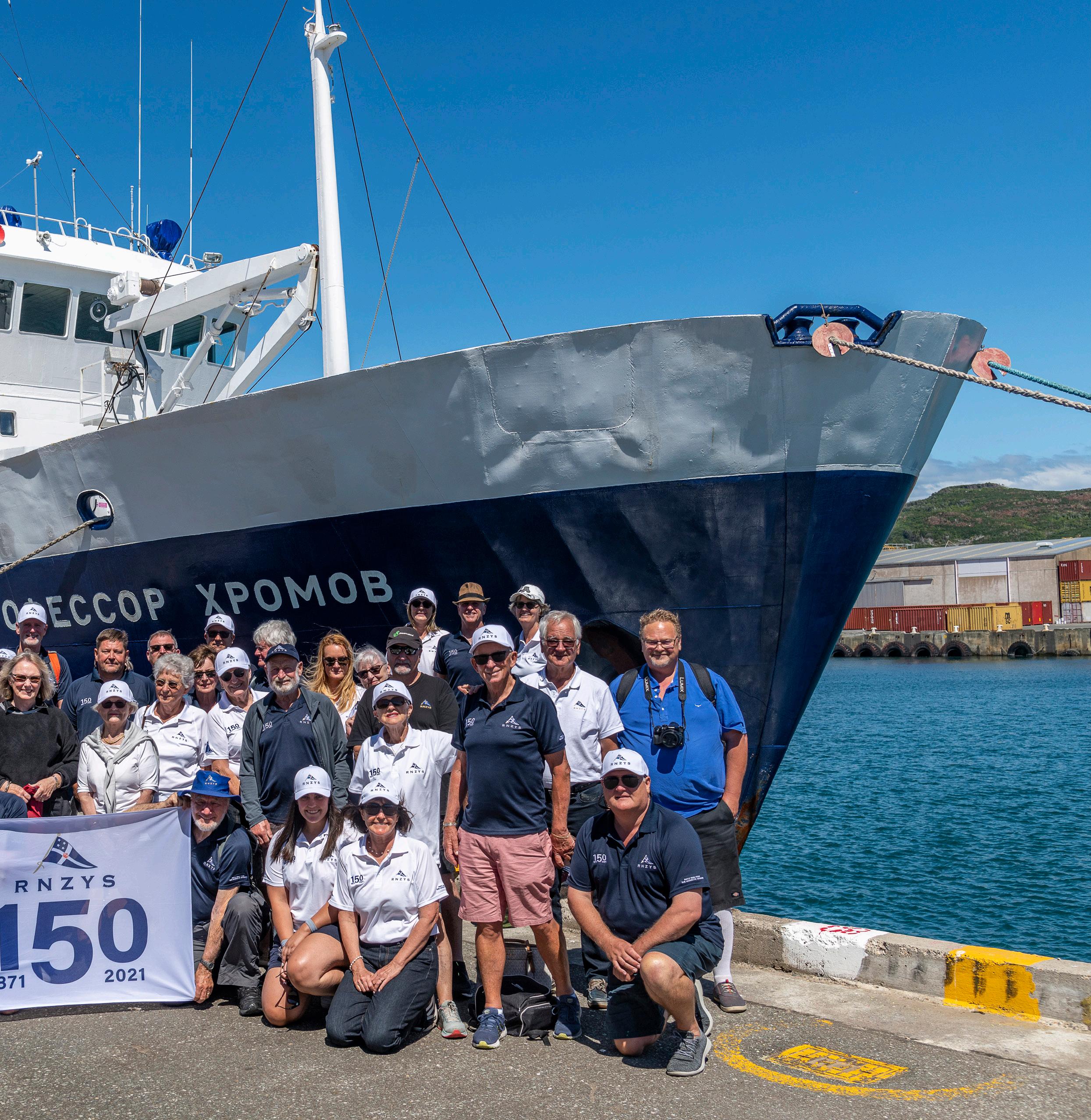
appointed Membership Manager Nikki Harkin. Life Member Colin Carran was travelling with his three sons.
“It was a great Squadron group that mixed extremely well,” says Colin. “I am sure that had to do with our common interests and backgrounds.”
Sheryl Lanigan: “One of the things the expedition crew remarked on was that they enjoyed having people with a boating background on board. People who knew what clothes to wear, how to put on lifejackets, negotiate getting on and off Zodiacs and so on. We were familiar with how to look after ourselves on boats.”
Asked to name her highlight, Sheryl found the question difficult to answer. “It was all amazing.” She described Campbell Island as being about the sealions, albatrosses and plants. The Auckland Islands were about the history of doomed human attempts at habitation over the years, while the Snares were all about the penguins.
Nobody is allowed ashore at the Snares, so all the viewing was from the Zodiacs. The pristine environment looked untouched since the beginning of time.
Peter Taylor described the whole expedition experience as very exciting. Perhaps an understatement given he had a closer encounter with nature than he might have liked when a sealion bull charged out of

1
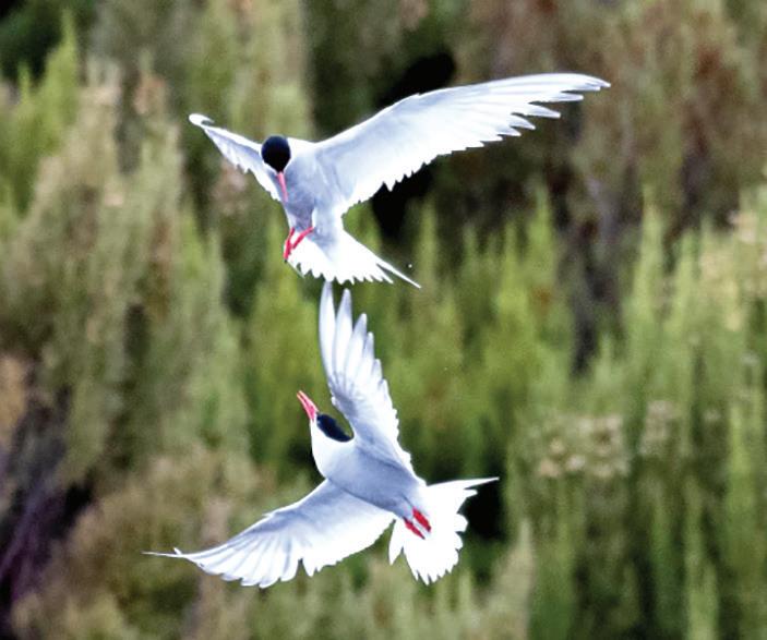
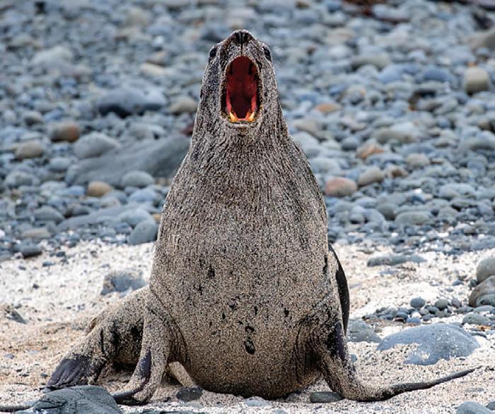
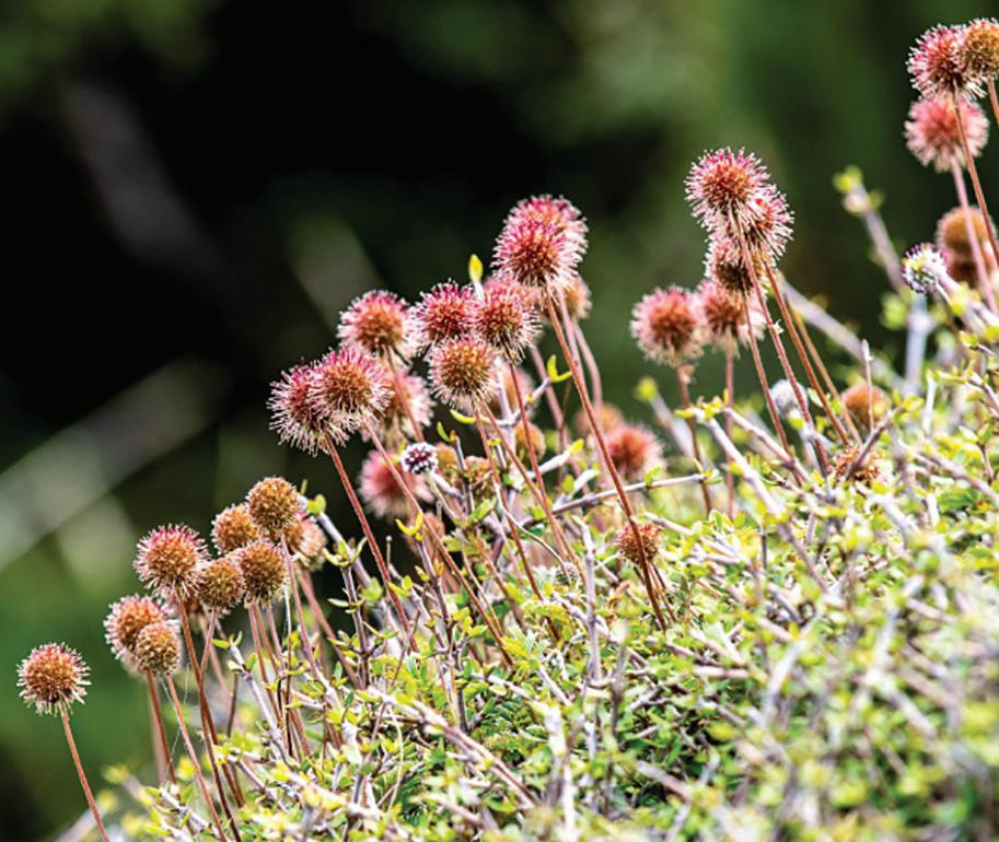
2 2 The Sub Antarctic Islands are a nature photographer’s paradise, with an abundance of fauna and flora to ‘capture’ on film. Most of the guests clicked away and came back with wonderful records of what they saw, but the guides were also equipped with professional equipment and supplied each guest with a memory stick loaded with images. This is a small selection. 1) Southern Royal Albatross - Campbell Island; 2) Antarctic terns - Campbell Island; 3) Campbell Island shag; 4) Hooker's sealion, Enderby Island; 5) Hooker's sealion pups, Enderby Island; 6) Hooker's sealion - female and pup; 7) Pleurophyllum Speciosum (Subantarctic Daisy); 8) Granitic rocks and kelp, the Snares; 9) Acaena magellanica (Subantarctic Bidybid).

3


4 5 6

7 8 9

the bush during one of the walks. “It was really our first exposure to the real quality of New Zealand’s fauna and flora,” he says.
“It made us quite proud of New Zealand to have such an extensive and unique range of plant and animal species. It was wonderful watching the penguins and seals and going for fantastic walks in such an unspoilt environment.”
The shore excursions were accompanied by guides, who shared expert knowledge of the wildlife and flora. “One of the guides remarked that there was more sex and violence on the beaches than you would ever see in a Tarantino movie,” chuckles Nikki Harkin.
Constant wind is an expected feature of high latitude cruising – old salts talk of the Roaring Forties, Furious Fifties and Screaming Sixties. Some remarked on the challenges of launching and retrieving Zodiacs in 40 knots, while Peter Taylor notes: “It was not uncommon to be out walking in 50 knots of wind. Everybody worked out their own level of ability and comfort and took part in activities accordingly.”
The roughest sea passage was between Campbell Island and the Auckland Islands where 70 knot winds and 6m beam seas were encountered. “It made one think of the saying that if you have never been seasick, it is because you have never been in a small enough boat in a big enough sea,” Rita Taylor laughs. “But, if we had not experienced those conditions, we probably would have felt cheated.”
Understandably, there were occasions when the dining room population reduced dramatically, but mostly the group took conditions in their stride.
The consensus was that the experience left the group invigorated and enriched, with ongoing conversations about the creation of an RNZYS Travel Club to offer members similar opportunities in the future.
By Tony Whiting I was on watch on a moonless night sailing down the Canterbury Coast, sitting in one of my favourite spots on the windward cockpit coaming when I heard a familiar sound. It was the exhale of a dolphin riding the aft pressure wave. In the luminescence you could see their size and shape – definitely Dusky dolphins –always playful and fast as they darted in close to our transom.
They were like silver bullets in the luminescence, lighting up sparkling streaks through the bright foaming crest of the stern wake and the boil of turbulence from the propeller and rudder trailing aft. We were on our way South to Rakiura/Stewart

Photo Credit // Cory Silken
A tranquil Taranui 3 at anchor in Stewart Island

BY SAILORS, FOR SAILORS
New Zealand’s premier sailmaker, 100% owned and operated by kiwi sailors. Supporting local sailing since 1982.
by sailors, for sailors doylesails.com
Island to join other adventurous sailors for the Island Cruising South Island Rally. This is run by the energetic and very capable Viki Moore. We had been planning this trip for some time and our decision was to sail down the East Coast from our Auckland base.
It is a matter of personal choice which way you go, but this one suited us. The first leg to Napier is about 350 miles, a two-day passage. Napier is a great city. The yacht club and locals are very friendly. “You want to borrow a bike or a car, just sing out”. Great pubs and restaurants and bike trails.
Next leg to Lyttleton was similar, but the notorious Wairarapa coast was on our minds, so we chose a good weather window. We also covered this 350-mile leg in two days with only one strong southerly blow.
We were well out to sea and Taranui 3 handled this well; mainsail well reefed and staysail sheeted in hard. Best to be off the coastal shelf, we figured. The lovely part of this Southern Coast is that you get seriously into albatross country: at stages we were surrounded by large wandering albatross, Bullers mollymawks, grey headed, black browed.
These birds were curious about us sailing along, always giving us the eye as they soared by, never flapping, just dynamic soaring on those 3.3m wings.
Nick caught an albacore tuna off Castle Point in the warm waters as we were coming down the coast. We had sashimi and many excellent meals from this delicious fish.
Te Ana Marina in Lyttelton is new and very well set up, and also very welcoming. Lyttelton is a spectacular caldera and a walk up the bridle trail to the top of the Port Hills is well worthwhile. It’s a great view of the northern plains and the Southern Alps by the Rakaia gorge, Mt Hutt area. Also a good way to walk off too many beers and pizza from the New Year’s party the night before!
Our sail around Banks Peninsula was a reach and then a run until we got into fog off Moeraki. We had installed a new Furuno radar and chart plotter and they were invaluable, along with the Vesper AIS for motorsailing through this pea soup fog.
A number of boats were around, also keeping well out to sea, off the coastal shelf. My father, D’Arcy, had planned a similar trip 25 years ago on our sister ship Tequila. His intention was to go “in the wake of Cook” and was attempting this passage late in the summer in a figure eight, going down the North Island west coast and the South Island east coast. I joined Tequila in a chilly Lyttelton in 1997 and our sail down the Canterbury bight was easy and sunny.
Just south of Moeraki, we saw cloud approaching from the south and within 15 minutes it was blowing 30 knots hard on the nose on the coastal shelf. Huge seas built up and our relaxed state meant we reefed sail late. In the ensuing unravelling, we tore the mainsail, ripped the storm jib, the genoa furling line got wrapped around the propeller and the VHF radio didn’t work.
We were saved by the SSB radio, which enabled us to organise a tow to Port Chalmers. This was a sad end to our New Zealand circumnavigation and nobody was more disappointed than D’Arcy, a great seaman who uncharacteristically misread the weather.
Many lessons were learned from that trip and one that we now constantly apply is to get regular weather updates to be fully prepared at all times. This is the same sailing anywhere but especially on the southern coast, where those notorious southerlies whip up very quickly. The Southern Alps are a huge deflector of southwesterly storms from the Tasman and the Southern Ocean.
Our sail down the Catlin’s coast was lovely: many lighthouses and a few reefs, a number that had claimed ships in the early days. Foveaux Strait was calm as we passed by Ruapuke Island, still an independent state.
The entry into Rakiura is through a series of islands known as the Mutton Bird/Titi Islands. We could see the seasonally-used huts of the Rakiura Maori for their traditional gathering of Titi. We recognise these birds as the sooty shearwater, and they pass by our northern coast on their annual migration between these southern islands and the Aleutians up in Alaska.
New Zealand’s third largest island, Rakiura/ Stewart Island is certainly a southern paradise. It is about 65 km long and about 40 km across at its widest point. The main village is Oban on Half Moon Bay, facing northeast. This harbour is generally very sheltered and only about 20 nautical miles across to Bluff, where most people and supplies come through.
There are a series of large inlets on the north and east coasts. The largest of these is Patterson Inlet and it feels a bit like Port Fitzroy on steroids.

From left: Tony Whiting, grandchildren Mollie and Paul Barden and Margeret Wilson at Oban.
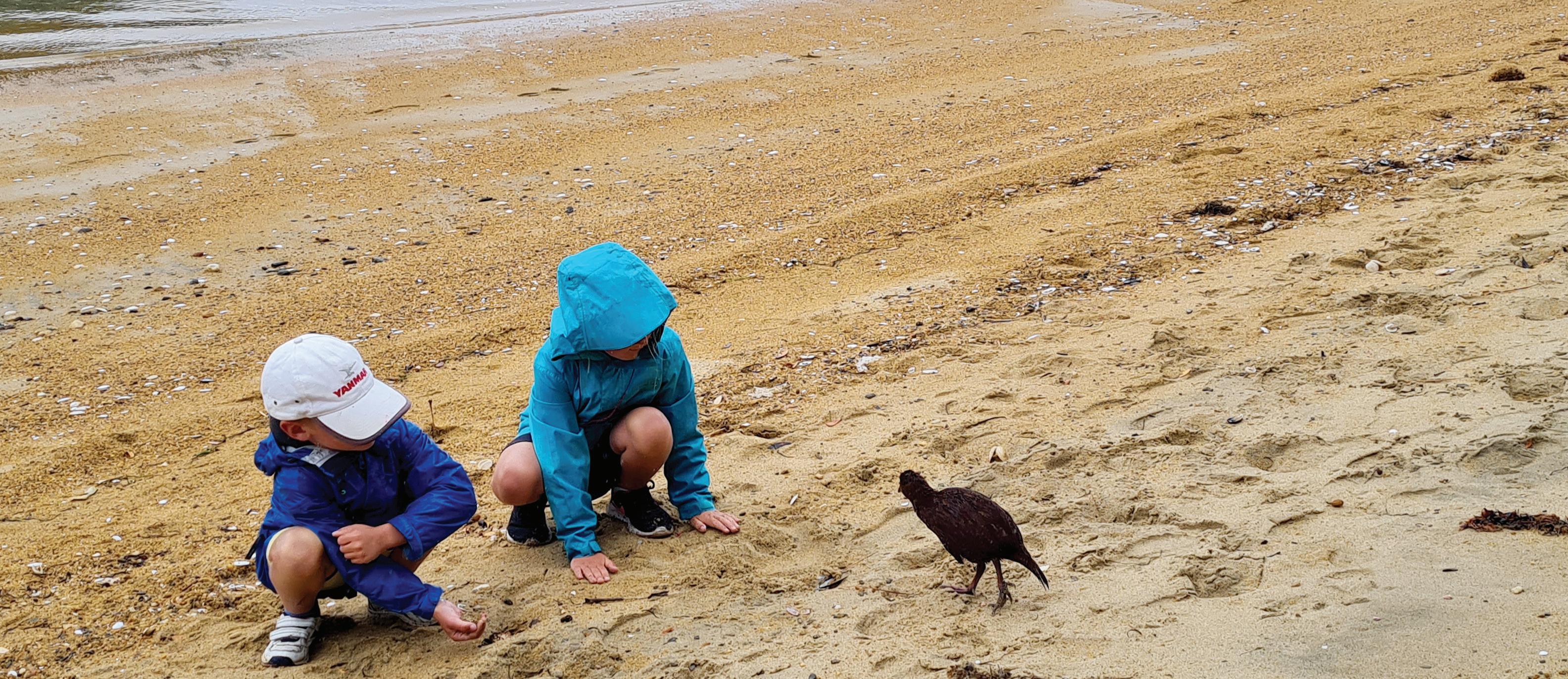
Paul and Mollie Barden examine a weka on the beach at Ulva Island..
There are a number of great anchorages and sheltered coves all around the inlet with the famous Ulva Island across the entrance. Visiting Ulva Island makes you feel you have stepped back into a primeval forest on Gondwana: huge totara, rimu, rata and miro trees, a floor of moss and ferns of every shade of green.
When we visited there, we saw kiwi during the day, fur seal pups, kaka, tui, bellbird, tomtit, red crowned parakeet and robins galore. You had to be careful not to be bowled over by the kereru/wood pigeons flying by. Saddlebacks dancing around the forest floor just added to the excitement.
Rakiura has had its share of logging, whaling, mining and some farming ventures, but currently the only sustainable businesses are tourism, hiker support, fishing of blue cod and rock lobster, salmon and mussel farming in Big Glory Bay and hunting parties trying to keep down the numbers of white tailed deer we saw bouncing around.
Due to the lack of agriculture and industry, the water in and around the inlet is really clear and the kelp forests are exceptional. We did a snorkel tour with Stewart Island Adventures and it was quite amazing, diving through the