OUTCROP Newsletter of the Rocky Mountain Association of Geologists
Volume 75 • No. 3 • March 2026
OUTCROP | March 2026
2
Vol. 75, No. 3 | www.rmag.org
OUTCROP Newsletter of the Rocky Mountain Association of Geologists
730 17th Street, B1, Denver, CO 80202 • 720-672-9898 The Rocky Mountain Association of Geologists (RMAG) is a nonprofit organization whose purposes are to promote interest in geology and allied sciences and their practical application, to foster scientific research and to encourage fellowship and cooperation among its members. The Outcrop is a monthly publication of the RMAG.
2026 OFFICERS AND BOARD OF DIRECTORS
RMAG STAFF
PRESIDENT
2nd VICE PRESIDENT-ELECT
EXECUTIVE DIRECTOR
Sandra Labrum slabrum@slb.com
Ashley Castaldo acastaldo@slb.com
Bridget Crowther bcrowther@rmag.org
PRESIDENT-ELECT
SECRETARY
LEAD EDITOR
Ali Sloan ali@4jresources.com
Stephanie Forstner sforstner@diagenyx.com
Danielle Robinson danielle.robinson@dvn.com
1st VICE PRESIDENT
TREASURER
Nate La Fontaine nlafontaine@sm-energy.com
Walter Nelson wnelson@integratedenergyresources.com
CONTRIBUTING EDITORS
1st VICE PRESIDENT-ELECT
TREASURER-ELECT
Danielle Robinson danielle.robinson@dvn.com
Dan Bassett dbassett@sm-energy.com
Nate La Fontaine nlafontaine@sm-energy.com
2nd VICE PRESIDENT
COUNSELOR
Lisa Wolff lwolff@bayless-cos.com
John Benton jhbenton@mines.edu
Bobby Schoen bschoen@sm-energy.com
ADVERTISING INFORMATION
Rates and sizes can be found on page 48. Advertising rates apply to either black and white or color ads. Submit color ads in RGB color to be compatible with web format. Borders are recommended for advertisements that comprise less than one half page. Digital files must be PC compatible submitted in png, jpg, tif, pdf or eps formats at a minimum of 300 dpi. If you have any questions, please call the RMAG office at 720-672-9898. Ad copy, signed contract and payment must be received before advertising insertion. Contact the RMAG office for details. DEADLINES: Ad submissions are the 1st of every month for the following month’s publication. The Outcrop is a monthly publication of the Rocky Mountain Association of Geologists DESIGN/LAYOUT: Nate Silva | n8silva.com
Vol. 75, No. 3 | www.rmag.org
3 3
Elijah Adeniyi eadeniyi@slb.com
RMAG CODE OF CONDUCT RMAG promotes, provides, and expects professional behavior in every engagement that members and non-members have with the organization and each other. This includes respectful and inclusive interactions free of harassment, intimidation, and discrimination during both online and in-person events, as well as any content delivered by invited speakers and instructors. Oral, written or electronic communications that contain offensive comments or demeaning images related to race, color, religion, sex, national origin, age, disability, or appearance are not appropriate in any venue or media. RMAG reminds members of the diversity and mission statements found on our website. Please direct any questions to staff@rmag.org.
Outcrop | March 2026 OUTCROP
2026 NETWORKING EVENTS MARK YOUR CALENDARS
JANUARY 7 FEBRUARY 4 4 MARCH 1 APRIL 6 MAY 3 JUNE
JULY AUGUST
1 5 SEPTEMBER 2 OCTOBER 7 NOVEMBER 4 DECEMBER 2
HAPPY HOUR TUESDAY 4PM JANUARY FEBRUARY MARCH APRIL MAY JUNE
15 19 19 16 21 18
JULY 15 AUGUST 20 SEPTEMBER 17 OCTOBER 22 NOVEMBER 19
LUNCHEON WEDNESDAY 12PM
JANUARY FEBRUARY MARCH APRIL MAY JUNE
27 24 31 28 26 23
JULY 28 AUGUST 25 SEPTEMBER 29 OCTOBER 27 DECEMBER 1
COFFEE HOUR
FOR MORE INFORMATION ON THESE EVENTS AND TO SEE WHAT ELSE IS COMING VISIT: www.rmag.org/events
THURSDAY 10AM
OUTCROP Newsletter of the Rocky Mountain Association of Geologists
CONTENTS FEATURES
ASSOCIATION NEWS
14 Lead Story: Effects of Strengthening Monsoons on Fluvial Architecture and the Fate of Sequence Stratigraphic Surfaces in Fluvial-Deltaic Systems—Castlegate Sandstone, Book Cliffs, Utah
2 RMAG Summit Sponsors
36 Mineral Of The Quarter: Amethyst
4 RMAG Networking Events 6 2026 RMAG Summit Sponsorship Packet 11 101 Shortcourse Series: Geosteering With Zonevu
34 Vote for the Best Outcrop Cover of 2025 44 Yampa River And Green River Float Trip 47 RMAG Happy Hour
27 RMAG Coffee Hour
DEPARTMENTS 10 RMAG February 2026 Board Of Directors Meeting 12 President’s Letter
COVER PHOTO
30 March Hybrid Lunch Talk: Nate Suurmeyer
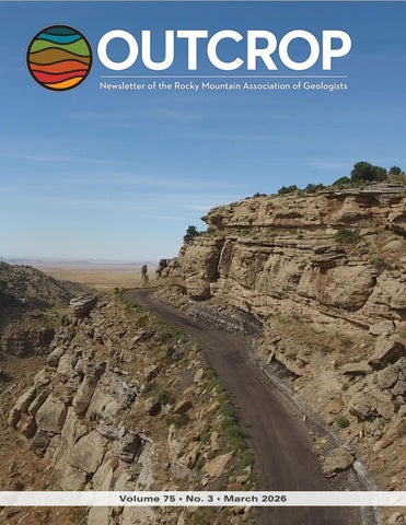
Laterally accreting bars and channel fill of the distal Castlegate Sandstone in Crescent Canyon, Book Cliffs, Utah. Photo by Brayton Keith.
32 April Hybrid Lunch Talk: Brandon Dugan 46 In The Pipeline 46 Welcome New RMAG Members! 48 Outcrop Advertising Rates 49 Calendar 49 Advertiser Index
Vol. 75, No. 3 | www.rmag.org
5
OUTCROP | March 2026
IN 2025YOUR SUMMIT SPONSORSHIP DOLLARS SUPPORTED: MEMBERS
1,200
EVENT ATTENDEES
1,400
WEBSITE VISITORS
8,000
OUTCROP READERS
8,000
COMMUNITY CONTACTS
7,000
EMAIL SUBSCRIBERS
4,000
infographic link
NETWORKING EVENTS
28
CONTINUING EDUCATION EVENTS
13
FIELD TRIPS
8
OUTCROP | March 2026
6
2 0 2 6
Vol. 75, No. 3 | www.rmag.org
October 24, 2025 Geoscience Community: We greatly appreciate every Summit Sponsor and Event Sponsor who contributed to RMAG over the last year. Your support is essential to our organization. In 2025, the Rocky Mountain Association of Geologists was proud to host a dynamic lineup of events, including the North American Helium & Hydrogen conference, which examined the quickly growing field. Members explored the beauty and geological wonders of the Grand Canyon and the San Jaun’s as well geology across the state. Volunteers shared their passion for geoscience with students across the region through classroom visits and community festivals. Members also enjoyed numerous opportunities to connect outside the office through monthly lunches, coffees, happy hours, and our annual Golf Tournament. Looking ahead, 2026 brings new opportunities for RMAG and our partners. Your financial support allows us to start the year off with a luncheon on the State of the Industry before diving into the impacts of new and evolving technologies on industry including in AI’s ever-growing presence. Plans are coming together to host a fundamentals class series throughout the year, two separate symposiums on the research out of USGS and research on the Mowry. Networking in 2026 will include our regular happy hours and coffee hour networking, plus we’ll have Rockbusters, the Golf Tournament and we’re bringing back the Clay Shoot. With your support RMAG Members share the wonders of earth sciences through community and school outreach. Finally, your financial support is crucial to our publication efforts, which include the monthly Outcrop newsletter and the quarterly Mountain Geologist journal. Your financial commitment includes enrollment opportunities across all the RMAG events, whether joining the educational opportunities and joining the comradery of the golf tournament your employees will gain access. RMAG also recognizes Summit Sponsors through in-person signage, on our website, in our publications, and on social media. Thank you to our current Summit Sponsors; we look forward to your continued support in 2026. For those not yet sponsoring, now is the perfect time to get involved. Sponsorship with RMAG directly supports the geoscience community – fueling education, networking, and professional development opportunities throughout the Rocky Mountain region. We invite you to review or sponsorship packages and find the level that best aligns with your company’s goals. Whether you choose to become an annual Summit Sponsor or support a single event, your partnership will help us advance geoscience education and keep our community thriving. Become a Summit Sponsor by contacting RMAG Executive Director, Bridget Crowther at bcrowther@rmag.org or 720-672-9898 to discuss opportunities and reserve your sponsorship for 2026. Sincerely, Sandra Labrum 2026 RMAG President
Bridget Crowther RMAG Executive Director
P: (720)672-9898 staff@rmag.org www.rmag.org Vol. 75, No. 3 | www.rmag.org
730 17th Street, B1 Denver, CO 80202
7
OUTCROP | March 2026
RMAG ANNUAL
SUMMIT SPONSORSHIP
PLATINUM, GOLD, & SILVER
SPONSORSHIP LEVEL
PLATINUM
GOLD
SILVER
$10,000
$5,000
$2,500
$835
$417
$208
$10,000
$5,000
$3,000
4
2
1
Contribution Level Monthly Cost
Benefits Value
RMAG MEMBERSHIP Active or Associate Membership in the Association for employees
RMAG WEBSITE BENEFITS Company Logo on Summit Sponsor Page of www.rmag.org
Large Logo & Link
Articles and Ads on special Advertisers web page
4 articles & 4 large ads
Medium Logo and Link 2 articles & 2 medium ads
Small Logo and Link 2 small ads
PUBLICATION ADVERTISING 12 months of Outcrop advertising: To receive 12 full months, company logos and ad art must be received no later than the 20th of the month in which you register. The Outcrop (receive benefits for 12 issues, monthly online publication
Full page ad
2/3 page ad
1/2 page ad
Company Logo listed as an annual Sponsor in The Outcrop
Large Logo
Medium Logo
Small Logo
EVENT ADVERTISING Sponsorship will be acknowledged as part the summit sponsors at all RMAG Events. Additional Sponsorship Opportunities will be available for all RMAG Events. Company Logo Looping in Slide Decks
Large logo individual Slide
Medium logo
Small Logo
Company Logo on Summit Sponsor Signage at all events
Large logo
Medium Logo
Small logo
RMAG EDUCATION EVENTS Registration points are cumulative and can be used for Symposiums or Short Courses. For example a Platinum Sponsor can send 4 people to the upcoming symposium conferences and register for 2 short courses. Total Educational Tickets
6
3
1
RMAG SOCIAL EVENTS Registration Points are cumulative and can be used for any social event. For example, 1 point means 1 golfer, or 1 registration for Rockbusters. *2 points can be used for a golf hole if that makes more sense for your company. Total Social Event Tickets
8
4
2
3
2
RMAG LUNCHEONS & FIELD TRIP TICKETS Registration Points are cumulative for luncheons or one day field trips. Total Luncheon & Field Trip Tickets
5
For all event tickets please contact the RMAG office at staff@rmag.org to use your spots.
OUTCROP | March 2026
8
Vol. 75, No. 3 | www.rmag.org
RMAG 2026 SUMMIT SPONSORSHIP Payment Options
All sponsor benefits event tickets follow RMAG event registration deadlines. All benefits end 12 months after registration. RMAG 2026 ANNUAL SUMMIT SPONSOR OPPORTUNITIES Platinum Sponsor Gold Sponsor Silver Sponsor
Summit Sponsorship benefit term is for 12 months! Specify type of payment on signed form, and send logo and advertisements to staff@rmag.org Company: Company Representative: Address: City:
State:
Phone:
Zip Code: Email:
Payment Method:
Credit Card
Credit Card Information: Select Card: AMEX
ACH
Check VISA
Mastercard
Discover
Name as it appears on Credit Card: Credit Card #: Expiration Date:
Security Code:
Signature: ACH: contact the RMAG office at staff@rmag.org for directions. Mail Checks payable to RMAG: Rocky Mountain Association of Geologists (RMAG) 730 17th Street, B1 Denver, CO 80202
RMAG events are subject to change. Cancellation or rescheduling of events does not give the sponsor the right to refund. Summit Sponsors will receive benefits at any new events added into the RMAG schedule.
Thank you for your generous support! P: (720)672-9898 staff@rmag.org www.rmag.org
Vol. 75, No. 3 | www.rmag.org
730 17th Street, B1 Denver, CO 80202
9
OUTCROP | March 2026
RMAG FEBRUARY 2026 BOARD OF DIRECTORS MEETING By Stephanie Forstner, Secretary sforstner@diagenyx.com
John C. Webb
Consulting Geologist Stratigraphy, Sedimentology and Petrography of Clastic and Carbonate Systems
Reservoir Characterization Petroleum, SWD, CCUS, Geothermal
OUTCROP | March 2026
Louisville, Colorado Johnwebb20@comcast.net 303.917.0644
camaraderie, and the January happy hour at Mad Macks in Golden had a fantastic turnout of 35. Whether you prefer caffeine or something a little stronger, there’s a social event for you! If you’ve been eyeing the 2026 Clay Shoot at Colorado Clays on Friday, May 8th, registration forms and advertising are coming soon. Expect some added fun with extra games and drawings this year. It’ll be a great event to bring colleagues and clients alike. Fun fact: Clay shooting guide was my first job ever, let me know if there is space on your team. A warm welcome to Richard Walther, who has joined the Publications Committee! The team is also excited to share that voting for the 2025 Best Outcrop Article is live! Cast your vote and show some love for your favorite piece from last year. The publication pipeline is full and varied: the March Outcrop features Brayton Keith’s work on Castlegate fluvial architecture, April brings Moones Alamooti’s piece on structural controls on Rockies geothermal systems, and May takes us north to Colleen Elliot’s exploration of the Ringing Rocks of Montana. The On The Rocks field trip committee has been hard at work, and the 2026 schedule is shaping up beautifully. A behind-the-scenes paleontology tour at DMNS with David Krause in February was a hit – the committee is already wondering if it should become an annual tradition. The Yampa/Green River five-day float trip (June 1–5) is already full with a waitlist, so if you missed it this year, keep an eye out for 2027. Still open: a family fossil trip to Kemmerer, Wyoming (June 20), an Upper Arkansas Valley trip from Leadville to Salida (June 26) focusing on Pleistocene/Holocene landforms, and a Denver Downtown Building Stones walking tour (July 11). Registration for day trips typically opens about six weeks in advance – check the RMAG website for the latest. Spring always brings a renewed sense of possibility. New field seasons, new ideas, and new chances to connect with the brilliant people that make up this community. Until next time… keep looking down (at the rocks, of course).
Greetings, fellow rock lovers! Spring is (sort of) in the air, this has been the absolute strangest CO ‘winter’, and if you squint at your calendar just right, you can almost see field trip season on the horizon. It’s a great time to be an RMAG member. A quick note on process: the February Board of Directors meeting was cancelled due to lack of quorum. However, the individual committees met as scheduled, and there is plenty to share from those conversations. Let’s start with some exciting news from Continuing Education: the February luncheon featuring Riley Brinkerhoff’s talk on upper cube development in the Uinta Basin drew 117 attendees – a record since before COVID! Whether you joined in person or online, that kind of energy speaks volumes about this community. I’m sure we’ll keep up the momentum at this month’s Luncheon talk Wednesday, March 4th on AI in Geoscience by Nate Suurmeyer. Looking further ahead: Brandon Dugan tackles Submarine Landslides in April, and Peter Blomquist takes us to the heights with the Geology of Colorado 14ers in May. It’s a great lineup – mark those calendars! On the Finance front, things are looking healthy heading into the new year. January saw strong membership revenue. Our Advisor Managed Investment account is up ~$18,800 in January. Steady footing as we move into 2026. The Membership Committee has been busy on all fronts. The January coffee at Huckleberry brought out about 10 members for some low-key geology
10
Vol. 75, No. 3 | www.rmag.org
101 SHORTCOURSE SERIES
GEOSTEERING WITH ZONEVU WEDNESDAY APRIL 29, 2026 8 AM - 12 PM DENVER EARTH RESOURCES LIBRARY Join us for a focused, half-day introduction to the fundamentals of geosteering using ZoneVu. This course is designed for geologists, engineers, and industry professionals who want a clear, working understanding of real-time well placement and how modern software supports better drilling decisions. In this hands-on session, we’ll cover: Core principles of geosteering and horizontal well placement, understanding and integrating real-time data, seismic, and completions, correlation strategies while drilling, navigating the ZoneVu interface and key workflows, practical tips for communicating with drilling teams Participants will work through guided examples in ZoneVu to see how interpretations evolve with incoming data and how small steering decisions can impact reservoir exposure. By the end of the morning, attendees will understand both the geological thinking behind geosteering and the practical tools within ZoneVu that support confident, defensible decisions at the rig and in the office.
Register at rmag.org/shortcourse $50 Members/ $75 Non-Members Vol. 75, No. 3 | www.rmag.org
11
OUTCROP | March 2026
PRESIDENT’S LETTER By Sandra Labrum slabrum@slb.com
The Role of Luck in Discovery
OUTCROP | March 2026
human. Technology refines our odds; it does not remove the leap. Perhaps what we have long called luck is really the intersection of preparation, experience, timing, and courage. It is the moment when years of learning meet opportunity and when someone decides to act despite uncertainty. This intersection is part of what makes our RMAG community so valuable. RMAG is more than a professional society; it is a living archive of shared insight. The talks we host, the papers we publish, and the conversations that happen before and after meetings pass down something essential: the accumulated judgment of generations of geoscientists who have navigated imperfect information and made decisions without guarantees. What can appear from the outside as “luck” is often the product of that shared foundation. In that spirit, we will be exploring these lucky turns in an upcoming series of talks featuring experienced geologists sharing the stories behind major Rocky Mountain field discoveries. I am looking forward to hearing not just what worked, but how. How uncertainty was weighed, how conviction was built, and perhaps where a little serendipity played its part. As we move into spring, a season that always carries a sense of renewal and possibility, I hope your own work is marked by thoughtful risk, steady preparation, and just enough fortune to keep discovery alive. And if the pot of gold at the end of your rainbow is not quite gold, may it at least prove to be a very convincing, high-quality pyrite sample. Warmly, —Sandra
Hi All, For some reason, March always makes me think about luck. Maybe it’s the season, maybe it’s the promise of spring, or maybe it’s just that in our profession, luck has always played a quiet, and sometimes not-so-quiet, role in the story of discovery. In the early days of oil and gas exploration, many of the major finds across the Rockies seemed to hinge on a bit of good fortune. A well placed just right. A structure interpreted boldly. A hunch that paid off. We’ve all heard the stories: the near misses, the dry holes that almost weren’t, and the prospects that only made sense in hindsight. Limited data meant greater uncertainty. Decisions were made with sparse control, hand-drawn maps, and an extraordinary reliance on observation and intuition. From the outside, success may have looked like fortune smiling on the brave. Yet beneath that “luck” was deep geologic reasoning, pattern recognition, and a willingness to accept risk. Today, we operate with more tools than ever before. Advanced logging suites, 3D seismic, powerful modeling software, and integrated datasets allow us to see into the subsurface with a level of detail our predecessors could only imagine. And increasingly, our conversations include artificial intelligence and machine learning where they fit, where numerical reasoning may be “good enough,” and where it is not. Has the geologist’s gut feel been replaced by technology? I would argue it has not, it has evolved. Our intuition is now informed by richer datasets and more sophisticated tools, but the act of interpretation, of choosing one model over another, of deciding when the evidence is sufficient, remains deeply
12
Vol. 75, No. 3 | www.rmag.org
PETROLEUM HISTORY INSTITUTE ANNUAL SYMPOSIUM AND FIELD TRIP From Oil Gushers to Energy Diversification California’s Petroleum Hub and Country Music Capital April 16-18, 2026, Bakersfield, California We invite you to join us in Bakersfield, California, April 16-18, 2026, for the annual symposium and field trip of the Petroleum History Institute. How about “Bakersfield” - the land of big agriculture, big oil, and, for those music aficionados, The Bakersfield Sound. The Kern County region ranks as the 4th largest oil-producing region in the country, albeit ranked 8th as a state in 2025. The city of Bakersfield lies at an elevation of 492 feet and is situated in the southern end of the San Joaquin Valley of California. Writer John McPhee described it as being so flat that one could stare out on the horizon and view the curvature of the earth. East of the Sierra Nevada Range and just a few miles north from the historic Fort Tejon along the northern perimeter of the Transverse Ranges, the region is noted for its agriculture production; however, its oil industry is even bigger, being home to 22 giant oil fields. With the 1899 discovery of the Kern River Oil Field, Kern County was ushered into the big leagues, leading to other notable discoveries throughout the valley including Coalinga, McKitterick, Midway-Sunset and Elk Hills oil fields, accompanied by huge gushers, and by 1904, Kern surpassed Texas in annual production. Today, the Kern County oil region is focused on the future with an emphasis on energy production via not just oil but also steam cogeneration for electricity, geothermal production, solar and wind energy, and carbon dioxide capture and storage. Our meeting will be held at the Double Tree Inn by Hilton, Bakersfield. Consider adding a little extra time to your visit and experience some of the local favorites: Buck Owens’ Crystal Palace, the California Living Museum, the Kern County Museum, Bakersfield Museum of Art, Buena Vista Museum of Natural History and Science, and Fort Tejon State Historic Park, the majestic Kern River Canyon drive, and experience its unique Basque restaurants. The Welcome Reception will be held on Thursday evening at the hotel, and the Symposium and Awards Banquet will be held on Friday. Saturday’s field trip will encompass many of the key localities in the petroleum history of the San Joaquin Valley including the historic McKittrick. Midway, Buena Vista, Elk Hills and Ten Section oil fields. Lunch will be at Taft’s West Kern Oil Museum which contains an excellent collection of cultural and historical exhibits, along with the best collection of oilfield equipment in California. On behalf of the PHI annual meeting organization committee, we look forward to seeing you in Bakersfield! Please submit an abstract for Friday’s Symposium (deadline is March 1, 2026). The abstracts should be sent to Bill Brice and Vaughn G. Thompson (wbrice@pitt.edu & geologistvaughn@gmail.com). Please send your registration form to: Petroleum History Institute, P. O. Box 165, Oil City, PA 16301. Hotel information is on the registration form. Please make hotel reservations directly to the hotel. Stephen Testa, Co-Chair; stesta@goldrush.com; (209) 402-6574 Vaughn G. Thompson; Co-Chair, geologistvaughn@gmail.com; (805) 794-0070 www.petroleumhistory.org Vol. 75, No. 3 | www.rmag.org
13
OUTCROP | March 2026
LEAD STORY
EFFECTS OF STRENGTHENING MONSOONS on Fluvial Architecture and the Fate of Sequence Stratigraphic Surfaces in Fluvial-Deltaic Systems
CASTLEGATE SANDSTONE, BOOK CLIFFS, UTAH
HE CASTLEGATE SANDSTONE IN THE BOOK CLIFFS OF UTAH
proximal, medial, or distal), smaller-scale elements (channels and bar forms) (Chamberlin & Hajek, 2019; Mitten et al., 2020), or the largest order surfaces such as sequence boundaries (Van Wagoner, 1990; Miall, 1994). This study aims to provide a comprehensive longitudinal architectural analysis assessing driving factors and tying together the proximal-distal Castlegate fluvial system. The Castlegate is historically interpreted as an incised-valley fill system, and is one of the birthplaces of the incised-valley fill model (Van Wagoner et al., 1990; Figure 1A). This interpretation views the basal-Castlegate surface as representing a regionally correlative 3rd order sequence boundary separating the fluvial Castlegate Sandstone from the underlying fluvial and shoreface deposits of the Desert Member of the Blackhawk Fm genetically and temporally. An early point of contention was the driver that
T
BRAYTON KEITH, Brayton.keith@DVN.com JOHN HOLBROOK, John.Holbrook@tcu.edu
is one of, if not the most studied fluvial outcrops in the world, appearing in publications stretching back over a century (e.g. Dutton, 1880). The capping fluvial unit of the 3rd order regression of the Mesaverde Group, the Campanian Castlegate is long studied by industry and academia, and the finer aspects of its origin has been a point of contention. The worldclass ~200 km of exposure along dip with strike-oriented canyons is ideal to perform a detailed analysis of the fluvial architecture of the Castlegate. Despite this, there surprisingly has not been a comprehensive fluvial architectural analysis considering lateral and longitudinal architectural shifts spanning the continuous exposure. Architectural studies have a tendency to focus on regions within a system (i.e.
OUTCROP | March 2026
14
Vol. 75, No. 3 | www.rmag.org
FIGURE 1: Regional interpretations of the sequence stratigraphy of the upper Blackhawk and Castlegate Sandstone. Figures A and
B represent the conventional sequence stratigraphic model of individual Castlegate and Desert Member IVFs with no tie between the Castlegate and underlying Blackhawk Formation. Figure C shows the new interpreted stratigraphic model tying the Castlegate Sandstone genetically and temporally to the Desert Member shoreface deposits with Castlegate fluvial strata directly feeding Desert Member marine strata (From Pattison, 2020). Model C is the preferred model for the Desert Member-Castlegate Sandstone interval. PRC- Woodside Canyon, ThC- Thompson Canyon.
Vol. 75, No. 3 | www.rmag.org
Blackhawk Fm, and as genetically and temporally tied down depositional dip to the Desert Member, feeding the coeval shoreface deposits (Pattison, 2018, 2019 a, b, c, 2020, Figure 1C). This reinterpretation is consistent with other 3rd order Cretaceous scour surfaces in the WIS considered regionally conformable initially but are now treated as lacking such temporal or genetic distinctions from underlying strata (Holbrook & Bhattacharya, 2012). This study utilized 9 outcrop reaches, primarily dispersed along depositional dip with 3 along strike in the proximal reaches of the system (Figure 2). On the outcrop, measured sections, lithofacies, and element scales were collected directly from cliff surface exposures. Full channel stories were measured in outcrop where available to determine bankfull depth. This was done using barforms showing complete or partial rollover (Holbrook & Wanas, 2014)
created this incised-valley system, either eustatic sea-level fall (Van Wagoner, 1991, 1995) or tectonic influence (Miall, 1994, 2001, 2014; Yoshida, 2000; Adams & Bhattacharya, 2005). Recently, studies are bringing the incised valley theory into question with many observations implying the basal boundary is a conformable facies contact throughout the system. Evidence supporting this includes lack of evidence of regional eustatic sea-level drop in the WIS (Howell et al., 2018), no change in provenance over the base-Castlegate boundary (Pettit et al., 2019; Sundell et al., 2024), consistent fluvial style and scale over the Blackhawk-Castlegate boundary (Adams & Bhattacharya, 2005), and lack of regionally trackable sequence stratigraphic surfaces (Miall & Arush, 2001; Hajek & Heller, 2012; Pattison, 2018). This has led to the reinterpretation of the Castlegate Sandstone as regionally conformable with the underlying
15
OUTCROP | March 2026
LEAD STORY
and used to assess vertical changes in average channel depth. A drone was utilized to take thousands of photos of each exposure which then are converted into 3D outcrop models to be used for interpretation of fluvial architectural elements. Fluvial architectural analysis begins by tracing out all bed-bounding surfaces and assigning orders for each surface based on bounding hierarchy (methods outlined in Miall, 1985 and Holbrook, 2001). Within the hierarchy of fluvial bounding surfaces, lower-order surfaces are bound by surfaces of higher orders, and surfaces may only be truncated by a surface of the same or higher order (Holbrook, 2001); i.e. lower-order bedforms are bound by higher-order channel scours, which then in turn may be bound by higher-order belt and valley-scale scours. Once these surfaces are interpreted and ranked, they may be used to dissect the fluvial outcrop for interpretation of patterns of incision versus aggradation, changes in fluvial style, as well as interpretation of autogenic and allogenic drivers altering the fluvial architecture along strike and dip. FIGURE 2: Map of structural features in the study area (modified from Along the proximal reaches of the CasPattison, 2018). Red stars represent outcrop locations used in this study. tlegate Sandstone, three outcrops were choBlue arrows represent sediment routing for the Castlegate Sandstone (Miall, sen for this study including the type-section, 2001). San Rafael Swell is uplifted after Castlegate deposition. Uncompahgre Joes Valley Reservoir, and Salina Canyon Uplift may have been active during part, or all of Castlegate deposition. Note providing the opportunity to make observathat each proximal outcrop is fed by a different thrust front, with sediment tions along a 110 km strike-oriented tranin Salina Canyon sourced from the Pavant Thrust, Joes Valley Reservoir from sect. Salina Canyon is the southernmost the Canyon Range Thrust, and the Castlegate Type-section sourced from proximal outcrop in the study and compristhe Charleston-Nebo Salient due to their distinct U-Pb signatures (Pettit et es stacked channel-belt sheets. The highest al., 2019). order surfaces observed in Salina Canyon are 5th order channel-belt scours (Figure as well as transitional bedforms (Figure 4). These 3). Architectural elements observed in Salina Canupper-flow regime sheets typically show a reduction yon are lower-flow regime channel-belts, upper-flow in flow regime, indicative of single-events scouring, regime channel-belts, and local splay-dominated and then infilling during waning-flow conditions. overbank deposits. The basal belts are consistentJoes Valley exposure comprises primarily channel ly lower-flow regime deposits, with upper-flow rebelts, channel-fill, and downstream accreting bargime bedforms increase in abundance up-section, forms, overbank splays, and heterolithic channel fill which coincide with an up-section increase in grainelements and valley-fills (Figure 5). The Joes Valley size. Lower-flow belts consist of trough cross-lamiexpresses an up-section shift, but differently from nated sands, while upper-flow regime sheets include chutes and pools, antidunes, and upper-plane beds Salina Canyon with complete absence of upper-flow OUTCROP | March 2026
16
Vol. 75, No. 3 | www.rmag.org
LEAD STORY
FIGURE 3: Orthomosaic of the outcrop studied (A) and bounding surfaces with color-coded
architectural elements (B) for Salina Canyon. Lower-order bounding surfaces are not visible due to lack of grain size variation and overall sheet-like nature of the channel-belt sands.
FIGURE 4: Stacked upper-flow channel-belt deposits near the top of the Salina Canyon exposure. Lower sheet bound
by a undulatory scour, filled with chutes & pools. Overlying this is another flood sheet infilled with planar beds and local convoluted bedding transitioning up into trough cross-beds. This vertical reduction in flow in an individual channel-fill is indicative of a flooding event where the channel is filled during waning flow. Person 1.68 m for scale.
Vol. 75, No. 3 | www.rmag.org
17
OUTCROP | March 2026
LEAD STORY
FIGURE 5: Orthomosaic of the outcrop studied (A) and bounding surfaces
with color-coded architectural elements (B) for Joes Valley Reservoir.
OUTCROP | March 2026
the three distinct styles of fluvial architecture in each location. This assertion is supported by cluster analysis of U-Pb data which argues each outcrop transect represents a distinctly different sediment source (Pettit et. al, 2019). These outcrops each show an up-section increase in discharge, and flashy discharge events. This is manifest through an up-section increase in the occurrence of upper-flow regime bedforms (Salina Canyon), stacked valley incisions and conglomeratic channels (Joes Valley), and overall increase in average flow depth (Joes Valley & type-section). This evidence supports an up-section increase in overall discharge throughout the system, and an up-section increase in flashy discharge likely associated with the strengthening of Campanian monsoons throughout Castlegate deposition. The medial reaches of the Castlegate Sandstone are captured in Sunnyside and Woodside Canyons. Sunnyside Canyon, once again, has two distinct intervals with the highest-order surfaces being 6th order channel-belt scours (Figure 8). The lower interval comprises channel-fill and downstream-accreting barforms with an average channel depth of ~5 m. This represents the typical downstream evolution of a fluvial channel from the type-section with overall increase in discharge and channel-depth. The upper interval consists primarily of small, ribbony channels nested in overbank facies. These are interpreted as representing the abandonment of the main Castlegate fluvial system at this location. Woodside Canyon transitions up-section from channel-belt sheets
regime bedforms. Instead, Joes Valley exposure transitions from stacked 6th order channel belts transitioning up-section to vertically stacked 7th order valley-fills. Above the first 7th order valley-scale surface, there is a significant increase in overbank preservation, increase in channel depth from 3.1 m in the lower interval to 4.5 m in the upper part, local conglomeratic channels and bars (Figure 6), as well as the occurrence of stacked valley-fills. 7th order valley surfaces overly the thickest overbank deposits where overbank is preserved as a terrace coeval to observed valleys. The Castlegate type-section is typified by braided river deposits. Channel-fill and downstream-accreting barforms bound by the highest-order surfaces representing channel-belt scale scours dominate the section. The Castlegate type-section also transitions up-section, though differently than either Joes Valley or Salina Canyon. The type-section comprises two distinct intervals, transitioning from highly-amalgamated channel belts at the base to thicker, sheety channel belts with interbedded overbank lenses up-section (Figure 7). There is no observed valley-scale surfaces or upper-flow regime bedforms, though there is an increase in average flow depth. Complete channels in the lower interval averaging ~3 m in thickness increasing to 4.4 m in the upper interval. These proximal outcrops record 3 separate tributary systems of the Castlegate fluvial system reacting to differential subsidence, discharge, and sediment supply conditions. This variance is manifest in
18
Vol. 75, No. 3 | www.rmag.org
LEAD STORY
FIGURE 6:
Localized conglomeratic barform at Joes Valley Reservoir with conglomeratic channel fill on the right of the photo. Gravels in bar are up to 12 cm in diameter. Gravel bars are only observed in upper half of the exposure above the first 7th order surface.
Vol. 75, No. 3 | www.rmag.org
19
OUTCROP | March 2026
LEAD STORY
FIGURE 7: Orthomosaic of the outcrop studied (A) and bounding surfaces with color-
coded architectural elements (B) for the Castlegate type-section. (Image modified from VOG Group; Castlegate, VOG Group, https://v3geo.com/model/86)
OUTCROP | March 2026
20
Vol. 75, No. 3 | www.rmag.org
LEAD STORY calculated in this study at ~24 km, which lies in agreement with previous studies which have calculated values between 20-30 km (Trower et al., 2018; Petter, 2010). Backwater length, the maximum updip reach of the hydrodynamic influence of the sea on a fluvial channel, is calculated using mean grain size, bankfull channel depth, and system slope as outlined in van Yperen et al. 2021. Backwater length
at the base, to stacked 7th order valley-scale incisions of up to 20 m in the upper interval (Figure 9). These valleys have variable fill-types, including lacustrine deltaic to stacked channel-fills. Valleys of this scale are not observed at this scale anywhere else in the study area. Valleys at Woodside Canyon were not created by eustacy or tectonics. Backwater length was
FIGURE 8: Orthomosaic of the outcrop studied (A) and bounding surfaces with color-
coded architectural elements (B) for Sunnyside Canyon.
FIGURE 9: Orthomosaic of the outcrop studied (A) and bounding surfaces with color-
coded architectural elements (B) for Woodside Canyon. Vol. 75, No. 3 | www.rmag.org
21
OUTCROP | March 2026
LEAD STORY
FIGURE 10: Orthomosaic of the outcrop studied (A) and bounding surfaces with
color-coded architectural elements (B) for Crescent Canyon.
OUTCROP | March 2026
increase in discharge causes drawdown of the river equilibrium profile (Holbrook et al., 2006). This interpretation implies an up-dip origin of observed valleys with a limited down-dip propagation. This up-stream control would explain the lack of similar valleys down-dip and aligns with the interpretation of increasingly flashy discharge up stratigraphic section as observed in proximal exposures. Distal Castlegate outcrops studied are Crescent, West Blaze, and Thompson, and Sulfur Canyons, and only represent portions of the exposures in the proximal reaches of the system (Figure 1C). Crescent Canyon records the largest individual channel at ~19 m thick, and comprises large, laterally accreting barforms and the transition from typical ‘braided’ Castlegate to a meandering fluvial system (Figure 10). This is coincident with the downstream evolution of the Castlegate fluvial system with increasing discharge and sinuousity. Above this lies a 7-13 m trough cross-laminated channel sheet building out over the heterolithic, tidally influenced channel fill recording the progradation of the fluvial system, as it transitions into a more ‘proximal’ fluvial style. Blaze Canyon records distributary channels and their autogenic valleys incising into its coeval shoreface (Figure 11). These shows extreme marine
lies where the channel thalweg intersects sea-level. It is well documented in the modern, ancient, and flume studies that incised valleys may only propagate twice the backwater length (e.g. Blum, 1993; Shanley & McCabe, 1994; van Yperen et al., 2020). Given the scour depth of 20 m and an average channel depth of 4.8 m, this valley would need to record a sea-level drop of 15.2 m (scour depth - channel depth), which at the calculated slope of 0.0002 m/km would require shoreline progradation of 76 km with an associated incised valley stretching that same distance and tapering out up-dip. No largescale progradation, nor incised valley of this scale has been observed in the distal reached of the Castlegate Sandstone. It is possible that these valleys are evidence of the confluence of the tributary systems seen at Joes Valley and the type-section. River confluence has been recorded causing incision of 4-5x average channel depth during monsoon events in the modern Jumana River in Bangladesh (Best & Ashworth, 1997). This scenario is unlikely, as there are no indicators of flow-depth of that scale, as they are infilled with multi-story fill as opposed to single story fill of an individual channel of that scale. These valleys are most likely buffer valleys formed through monsoon-driven flood scour, where the substantial
22
Vol. 75, No. 3 | www.rmag.org
LEAD STORY
FIGURE 11: Orthomosaic of the outcrop studied (A) and bounding surfaces with color-
coded architectural elements (B) for West Blaze Canyon.
Vol. 75, No. 3 | www.rmag.org
interval representing an overall shallowing throughout deposition. The three sources identified in the proximal transect collectively record evidence of an up-section climatic shift resulting in increased stream power and more discharge variation with intensive flooding events. This likely reflects an increase in strength of the Campanian monsoonal climate. The Campanian WIS is known to be dominated by monsoonal climate with extremely variable seasonal temperatures and precipitation (Kump & Slingerland, 1999; Fricke et al., 2010; Burgener et al., 2019). Though each drainage expresses this differently in their preserved architecture, the collective response of the Castlegate drainage is that of increased seasonal monsoonal conditions throughout Castlegate deposition. This is best expressed in the Salina Canyon area where the system progresses upward from lower to upper-flow-regime channel belt preservation and is recorded in buffer valleys present at Joes Valley and Woodside Canyon. Several studies (e.g. Van Wagoner, 1991, 1995; Miall, 1994, 2001, 2014; Yoshida, 2000; Adams & Bhattacharya, 2005) have attempted to track sequence stratigraphic surfaces from the most proximal to most distal outcrops without success. This
influence (double mud-drapes, Teredolites burrows, herringbone cross-bedding, and shell lag deposits) and is well within backwater length, which during storm events may experience induced scour of 3x normal flow depth (Trower et al., 2019). Thompson Canyon outcrop records a prograding estuarine delta as the Castlegate fluvial system reaches the WIS (Figure 12). This prograding nature of this estuarine delta is apparent with the up-section transition from delta front clinoforms and terminal distributary channels, capped with a mouth bar complex, which is overlain by subaqueous distributary channels, and finally tidally influenced subaerial channels and tidal flat deposits (Figure 13). Tidal evidence includes brackish teredolites, climbing ripples, double muddrapes, bi-directional and lenticular-flaser bedding throughout the section. Finally, Sulfur Canyon is the most distal outcrop of the study and records the final progradational pulses of the Castlegate Sandstone. This outcrop comprises tidal flats and channels, prodelta clinoforms, and terminal distributary channels (Figure 14). These deposits record a continual shallowing-up sequence, transitioning from deeper-water diplocriterion and arenicolites traces in the prodelta deposits to skolithos and ophiomorpha and bivalve fragments in the upper tidally dominated
23
OUTCROP | March 2026
LEAD STORY
FIGURE 12: Orthomosaic of the outcrop studied (A) and bounding surfaces with
color-coded architectural elements (B) for Thompson Canyon.
FIGURE 13:
Schematic of bayhead deltas in crosssectional and planview (Modified from Aschoff et al., 2018). Deposits observed in Thompson Canyon represent medial delta front facies (A) transitioning up-section into proximal delta front facies (B, C) and capped by delta plain (D, E).
OUTCROP | March 2026
24
Vol. 75, No. 3 | www.rmag.org
LEAD STORY
FIGURE 14: Orthomosaic of the outcrop studied (A) and bounding surfaces with
color-coded architectural elements (B) for Sulfur Canyon.
FIGURE 15: Simplified schematic longitudinal section of the Book Cliffs outcrops of the Castlegate Sandstone into their Desert
Member marine equivalent. The base of the amalgamated channel sands typically used to identify the base of the Castlegate Sandstone is often cryptic and migrates up or down-section by multiple channel stories locally. This indicates that this contact is a regionally conformable, simple facies contact. Sequence stratigraphic surfaces (From Pattison, 2018, 2019a, b, 2020) are trackable from marine strata into the near-shore fluvial, but all regionally trackable surfaces cease to exist up-dip, and are all cryptic, or gone by Woodside Canyon. It is important to note that these outcrops are unlikely representative of one continuous fluvial system.
Vol. 75, No. 3 | www.rmag.org
25
OUTCROP | March 2026
LEAD STORY
FIGURE 16: Satellite imagery showing outcrop locations and associated figures of architectural elements. Important features and elements are noted for each outcrop. Red arrows depict interpreted connection of exposures along the down-stream profile of the Castlegate Sandstone.
OUTCROP | March 2026
study supports this assertion. We conclude that these exposures are recording very different up-dip (climate and tectonics) and down-dip (base-level) allogenic drivers of architecture that have a finite limit of up-down dip correlation. The basal Castlegate Sandstone scour surface is not a regionally trackable sequence stratigraphic surface (Figure 15), and is observed locally interfingering laterally with the muddy, overbank-rich deposits of the underlying Blackhawk Formation (e.g. Figure 9). It is simply a lithostratigraphic contact comprising many discontinuous, local scour contacts. Surfaces may also not be trackable laterally, as the Castlegate represents multiple transects responding to varying drivers as is observed in its proximal reaches, rather than one continuous downstream profile. Up-dip controls on architecture have a limit on down-dip reach, and eustatic drivers that have a limit of up-dip propagation; thus, it is likely that within many fluvial systems that these surfaces may never connect or be trackable throughout the system.
REFERENCES Aschoff, J. L., Olariu, C., & Steel, R. J. (2018). Recognition and significance of bayhead delta Deposits in the rock record: A comparison of modern and ancient systems. Sedimentology, 65(1), 62-95. Best, J. L., & Ashworth, P. J. (1997). Scour in large braided rivers and the recognition of sequence stratigraphic boundaries. Nature, 387(6630), 275-277. Blum, M. D. (1993). Genesis and architecture of incised valley fill sequences: a late Quaternary example from the Colorado River, Gulf Coastal Plain of Texas. Burgener, L., Hyland, E., Huntington, K. W., Kelson, J. R., & Sewall, J. O. (2019). Revisiting the equable climate problem during the Late Cretaceous greenhouse using paleosol carbonate clumped isotope temperatures from the Campanian of the Western Interior Basin, USA. Palaeogeography, Palaeoclimatology, Palaeoecology, 516, 244-267. Chamberlin, E. P., & Hajek, E. A. (2019). Using bar preservation to constrain reworking in channel-dominated fluvial stratigraphy. Geology, 47(6), 531-534. Dutton, C.E. (1880). Geology of the High Plateaus of Utah. Department of the Interior, U.S. Geographical and Geological Survey of the Rocky Mountain Region. Fricke, H. C., Foreman, B. Z., & Sewall, J. O. (2010). Integrated climate model-oxygen isotope evidence for a North American monsoon during the Late Cretaceous. Earth and Planetary Science Letters, 289(1-2), 11-21. Hajek, E. A., & Heller, P. L. (2012). Flow-depth scaling in alluvial architecture and nonmarine sequence stratigraphy: example from the
26
Vol. 75, No. 3 | www.rmag.org
LEAD STORY Castlegate Sandstone, central Utah, USA. Journal of Sedimentary Research, 82(2), 121-130. Holbrook, J. (2001). Origin, genetic interrelationships, and stratigraphy over the continuum of fluvial channel-form bounding surfaces: an illustration from middle Cretaceous strata, southeastern Colorado. Sedimentary Geology, 144(3-4), 179-222. Holbrook, J., Scott, R. W., & Oboh-Ikuenobe, F. E. (2006). Base-level buffers and buttresses: a model for upstream versus downstream control on fluvial geometry and architecture within sequences. Journal of sedimentary research, 76(1), 162-174. Holbrook, J. M., & Bhattacharya, J. P. (2012). Reappraisal of the sequence boundary in time and space: case and considerations for an SU (subaerial unconformity) that is not a sediment bypass surface, a time barrier, or an unconformity. Earth-Science Reviews, 113(3-4), 271-302. Holbrook, J., & Wanas, H. (2014). A fulcrum approach to assessing source-to-sink mass balance using channel paleohydrologic paramaters derivable from common fluvial data sets with an example from the Cretaceous of Egypt. Journal of Sedimentary Research, 84(5), 349-372. Howell, J. A., Eide, C. H., & Hartley, A. (2018). No evidence for significant sea level fall in the Cretaceous strata of the Book Cliffs of eastern
Vol. 75, No. 3 | www.rmag.org
27
OUTCROP | March 2026
LEAD STORY
OUTCROP | March 2026
in a regressively stacked succession of shoreline sand bodies, Campanian Desert member to Lower Castlegate Sandstone interval, Book Cliffs, Utah–Colorado, USA. Sedimentology, 67(1), 390-430. Petter, A. L. (2010). Stratigraphic implications of the spatial and temporal variability in sediment transport in rivers, deltas, and shelf margins. The University of Texas at Austin. Pettit, B. S., Blum, M., Pecha, M., McLean, N., Bartschi, N. C., & Saylor, J. E. (2019). Detrital-Zircon U-PB Paleodrainage reconstruction and Geochronology of the Campanian Blackhawk–Castlegate succession, Wasatch plateau and book cliffs, Utah, USA. Journal of Sedimentary Research, 89(4), 273-292. Shanley, K. W., & McCabe, P. J. (1994). Perspectives on the sequence stratigraphy of continental strata. AAPG bulletin, 78(4), 544-568. Sundell, K. E., Gehrels, G. E., D. Blum, M., Saylor, J. E., Pecha, M. E., & Hundley, B. P. (2024). An exploratory study of “large‐n” detrital zircon geochronology of the Book Cliffs, UT via rapid (3 s/analysis) U–Pb dating. Basin Research, 36(1), e12840. Trower, E. J., Ganti, V., Fischer, W. W., & Lamb, M. P. (2018). Erosional surfaces in the Upper Cretaceous Castlegate Sandstone (Utah, USA): Sequence boundaries or autogenic scour from backwater hydrodynamics?. Geology, 46(8), 707-710. Van Wagoner, J. C., Mitchum, R. M., Campion, K. M., and Rahmanian, V. D. (1990). Siliciclastic Sequence Stratigraphy in Well Logs, Cores, and Outcrops. American Association of Petroleum Geologists, Methods in Exploration Series 7, 1-55. Van Wagoner, J. C. (1991). Sequence stratigraphy and facies architecture of the Desert Member of the Blackhawk Formation and the Castlegate Formation in the Book Cliffs of eastern Utah and western Colorado, in Van Wagoner, J.C., Nummedal, D., Jones, C.R., Taylor, D.R., Jennette, D.C., and Riley, G.W., eds., Sequence Stratigraphy Applications to Shelf Sandstone Reservoirs: Outcrop to Subsurface Examples. American Association of Petroleum Geologists, Field Conference Guidebook. Van Wagoner, J. C. (1995). Sequence stratigraphy and marine to nonmarine facies architecture of foreland basin strata, Book Cliffs, Utah, U.S.A., in Van Wagoner, J.C., and Bertram, G.T., eds., Sequence Stratigraphy of Foreland Basin Deposits: Outcrop and Subsurface Examples from the Cretaceous of North America. American Association of Petroleum Geologists, Memoir 64, 137–223. van Yperen, A. E., Holbrook, J. M., Poyatos‐Moré, M., Myers, C., & Midtkandal, I. (2021). Low‐accommodation and backwater effects on sequence stratigraphic surfaces and depositional architecture of fluvio‐deltaic settings (Cretaceous Mesa Rica Sandstone, Dakota Group, USA). Basin Research, 33(1), 513-543. Yoshida, S. (2000). Sequence and facies architecture of the upper Blackhawk formation and the lower Castlegate Sandstone (Upper Cretaceous), Book Cliffs, Utah, USA. Sedimentary Geology, 136(3-4), 239-276.
Utah. In AAPG ACE 2018. Kump, L. R., & Slingerland, R. L. (1999). Circulation and stratification of the early Turonian Western Interior Seaway: Sensitivity to a variety of forcings. Special Paper of the Geological Society of America, 332, 181-190. Miall, A. D. (1985). Architectural-element analysis: A new method of facies analysis applied to fluvial deposits. Earth-science reviews. 22(4), 261-308. Miall, A. D. (1994). Reconstructing fluvial macroform architecture from two-dimensional outcrops; examples from the Castlegate Sandstone, Book Cliffs, Utah. Journal of Sedimentary Research, 64(2b), 146-158. Miall, A. D., & Arush, M. (2001). The Castlegate Sandstone of the Book Cliffs, Utah: sequence stratigraphy, paleogeography, and tectonic controls. Journal of Sedimentary Research, 71(4), 537-548. Miall, A. (2014). The emptiness of the stratigraphic record: a preliminary evaluation of missing time in the Mesaverde Group, Book Cliffs, Utah, USA. Journal of Sedimentary Research, 84(6), 457-469. doi:10.2110/jsr.2014.40 Mitten, A. J., Howell, L. P., Clarke, S. M., & Pringle, J. K. (2020). Controls on the deposition and preservation of architectural elements within a fluvial multi-storey sandbody. Sedimentary Geology, 401, 105629. Pattison, S. A. (2018). Rethinking the incised-valley fill paradigm for Campanian Book Cliffs strata, Utah–Colorado, USA: evidence for discrete parasequence-scale, shoreface incised channel fills. Journal of Sedimentary Research, 88(12), 1381-1412. Pattison, S. A. (2019). High resolution linkage of channel-coastal plain and shallow marine facies belts, Desert Member to Lower Castlegate Sandstone stratigraphic interval, Book Cliffs, Utah-Colorado, USA. GSA Bulletin, 131(9-10), 1643-1672. Pattison, S. A. (2020). Sediment‐supply‐dominated stratal architectures
28
Vol. 75, No. 3 | www.rmag.org
Detailed and accurate geology at your fingertips in Petra, GeoGraphix, ArcGIS, AccuMap, geoSCOUT and other digital mapping applications
Western Canada Geological Edge Set
Energy Alternatives & Critical Minerals - Canada Western USA Geological Edge Set Eastern USA & Eastern Canada Geological Edge Set
Energy Alternatives & Critical Minerals - USA
Central USA Geological Edge Set Mexico Geological Edge Set
Map layers provided in shapefile format for easy import into all mapping applications. Deliverables include: formation limits, outcrops, subcrop edges, O&G fields, structural elements, reefs, shorelines, channels, production fairways, shale gas trends, structure contours, isopachs, general culture, renewable & non-renewable energy projects, mineral deposits, mines, Petra Thematic Map projects, GeoGraphix GeoAtlas projects, ArcGIS MXD and Layer files, regional cross-sections, and full technical support.
Vol. 75, No. 3 | www.rmag.org
For more information: Joel Harding at +1 403 870 8122 29 joelharding@geoedges.com www.geoedges.com
OUTCROP | March 2026
HYBRID LUNCH TALK Speaker: Nate Suurmeyer Date: March 4, 2026 | 12:00 pm - 1:00 pm
The New Exploration Tool GenAI That Builds the Solutions You’ve Always Wanted By Nate Suurmeyer, ThinkOnward
with clearer insights into how these tools work, where they excel, where they fail, and experiments you can try immediately. Geoscientists are inherently creative problem-solvers with deep insights into their data and GenAI coding tools finally give you the means to build what you need, test your hypotheses faster, and understand your data better, all while maintaining scientific rigor and ethical practices.
Large language models have moved from novelty to a near necessity, offering geoscientists the ability to turn their creative ideas into working code, analytical workflows, and custom tools. This session demystifies what GenAI actually is, sophisticated pattern matching rather than a search engine, along three practical methods: Retrieval-Augmented Generation (RAG), prompting and context, and code generation. You’ll leave the conversation
NATE SUURMEYER is a geoscientist with a passion for finding new ways of working for over 19 years in unconventionals, deep water exploration, and digitalization. He’s been with ThinkOnwards since its beginning and is eager to see how different brains can solve some of our Industry’s biggest needs.
OUTCROP | March 2026
30
Vol. 75, No. 3 | www.rmag.org
Stable Isotope Laboratory
Oil Gas Water Serving Global Energy since 2006 Contact us today: +1 (303) 531-2030 - digforenergy.com Vol. Vol. 74, 75, No. No. 10 3 | | www.rmag.org www.rmag.org
27 31
OUTCROP OUTCROP | October | March 2025 2026
HYBRID LUNCH TALK Speaker: Brandon Dugan Date: April 1, 2026 | 12:00 pm - 1:00 pm
IODP3-NSF Expedition 501 Offshore Freshened Groundwater and “Aquifer” Systems in the New England Continental Shelf By Brandon Dugan, Colorado School of Mines and pumped groundwater from the nearshore sites document a transition from seawater salinity to less than 2% of seawater salinity within the upper 125 mbsf. Furthest offshore, two freshened zones with salinity that is ~50% of seawater salinity exist above 300 mbsf. The freshened water salinity is consistent throughout marine and terrestrial sediments both mud-rich and sand-rich. Preliminary isotope analysis suggested the freshened water is of Late Pleistocene origin. Compared to salinity, interstitial water chemistry, including alkalinity, sulfide, and ammonium concentrations, demonstrates more nuanced patterns, with distinct profiles as well as absolute values downcore. This integrated research program elucidates the complexity of the freshened system beneath the southern New England shelf, and has implications for understanding other OFG systems worldwide.
IODP3-NSF Expedition 501 drilled three sites along a 45 km-long, NNW-SSE transect on the southern New England continental shelf offshore Nantucket and Martha’s Vineyard to characterize an extensive offshore freshened groundwater (OFG) system. Each site was investigated with drilling, coring, wireline logging, and groundwater pumping. Long-term observatories were installed in two offshore sites to monitor formation resistivity, temperature, and pressure. Visual core description, smear slide analyses, and core and downhole petrophysical logging document an unconsolidated sedimentary package consisting of alternating layers of sand and mud. The deeper sedimentary section is Cretaceous and was deposited in a terrestrial environment. The shallow sedimentary section ranges from Paleocene to Pleistocene and was deposited in a marine environment. Interstitial water
BRANDON DUGAN, Brandon is a professor and associate department head of Geophysics at Colorado School of Mines. Before joining Mines, Brandon earned a bachelor’s degree in geo-engineering from the University of Minnesota, Twin Cities and a Ph.D. in geosciences from Penn State University, completed a Mendenhall postdoctoral fellowship with the US Geological Survey, and was a professor of Earth Science at Rice University. In his research, he couples theory, experiments, and models to understand the interactions of fluids and solids in Earth’s shallow crust. As part of his research, Brandon regularly participates in field programs which has led to him spending about 2 years of his life on research vessels in our oceans. For research and teaching contributions, Brandon received the Asahiko Taira International Scientific Ocean Drilling Research Prize (2018) and a Blue Key Honor Society/Tau Beta Pi Outstanding Faculty Award (2017).
OUTCROP | March 2026
32
Vol. 75, No. 3 | www.rmag.org
Giant Exploration Projects & Plays
Thomasson Partner Associates www.tpaexpl.com 303-517-2969 tpaexpl@aol.com
Vol. 75, No. 3 | www.rmag.org
33
OUTCROP | March 2026
January 2025 Credit Jonatha Evans
February 2025 Photo by Peter Bucknam
West Spanish Peak as seen from La Veta
Geology Train in Precambrian Basement at Rock Tunnel
March 2025 Photo by Lauren and Dave Heerschop Raid Peak Basin in the Winds
Vote for the Best Outcrop Cover of 2025
July 2025 Photo by Ryan Allen Badlands near Glendive Montana containing Hell Creek Fossils
OUTCROP | March 2026
August 2025 Photo by Steve Lovelace Early Triassic Fluvial Deposits in the upper Red Peak Formation of the Chugwater Group are well exposed along the Red Wall of central WY. This unit preserves a divers track and trace fossil assemblage that offers a glimpse of post Permian extinction biotic recovery.
34
September 2025 Photo byJames Mauch, WSGS Photography of the Gros Ventre Slide in June 2025 100 years after it occurred. View is to the south from the north side of the Gros Ventre River Valley. Credit James Mauch Vol. 75, No. 3 | www.rmag.org
April 2025 Photo by Geoscience Outreach Committee Isabella Bird Community School students examining rocks with RMAG Geoscience Outreach Committee Volunteers.
May 2025 Photo by Geoffrey Ellis, USGS Serpentinized Rocks of The Trinity Ophiolite Complex, California
June 2025 Photo by Steve Quane
Hole in the Wall, a window through the Virgelle Sandstone in the White Cliffs Section of the Upper Missouri River Breaks National Monument, Montana
WWW.RMAG.ORG/OCBESTCOVERPHOTO
October 2025 Photo by Wyoming State Geological Survey Deep-seated landslide susceptibility in Teton County, Wyoming. Map view is centered over Teton Pass, with Wyoming Highway bisecting the image from the east to west. Darker red colors symbolize higher landslide susceptibility. Scale is 1:50,000. Vol. 75, No. 3 | www.rmag.org
November 2025 Photo by Jani Radebaugh
December 2025 Photo by Dan Bassett
The playa on the western edge of the Great Salt Lake
Loveland Pass, Colorado
35
OUTCROP | March 2026
MINERAL OF THE QUARTER By Ronald L. Parker Senior Geologist, Borehole Image Specialists, Centennial, CO 80111 ron@bhigeo.com
AMETHYST Clear-Headed Purple
Beautiful color gradation of dark purple to lilac in quartz euhedra from a fragment of a geode. This specimen displays a paragenetic layering that starts at the base, with chalcedony stained green by copper minerals or celadonite. The chalcedony grows inward, with a thin red iron oxide stripe, transitioning to a thin layer of druzy quartz that quickly passes into deep purple, prismatic amethyst. The rhombohedral (pyramidal) crystal faces at the top slowly reduce the intensity of the coloration. Locality unknown. 6 cm in the long dimension. Photo by Ronald L. Parker
OUTCROP | March 2026
36
Vol. 75, No. 3 | www.rmag.org
MINERAL OF THE QUARTER: AMETHYST
Football-sized amethyst crystals on display at an outdoor display from a Brazilian vendor at the 2017 Denver Gem and Mineral Show. These single crystals are unusually large and would be the correct size for carving into goblets. Photo by Ronald L. Parker.
Vol. 75, No. 3 | www.rmag.org
exhibiting all of the physical properties of quartz with added pizzazz. Amethyst color is a consequence of a trace amount of ferric iron (Fe3+) substitution for Si4+. When gamma radiation interacts with Fe3+, it creates Fe4+, which absorbs strongly at 545 nm (green), leaving purple as the reflected color. Amethyst purple is altered by increased temperature. Heating amethyst alters its color to yellow, orange, or red-brown, changing it to the variety citrine. Citrine is rare and more highly valued than amethyst, so much of the citrine in the marketplace is actually heat-treated amethyst. A rare variety of colored quartz, ametrine, blends citrine and amethyst. Amethyst sometimes develops “fingerprint” textures on pyramidal crystal faces, reflecting polysynthetic Brazil Law twinning. Amethyst forms in low- to medium-temperature groundwater and hydrothermal flow systems in
Amethyst (SiO2) is a purple variety of the mineral quartz that is a commonly available favorite of mineral collectors and mineral enthusiasts worldwide. The official birthstone for February, amethyst may be the gold medalist as the most widely distributed colored mineral in the world. This stems from wide availability, a pleasing appearance, and strong resilience as a gemstone. The name amethyst derives from the Greek meaning “not drunk,” and this name has colored human interpretation of the significance of this pretty purple mineral throughout history. Amethyst has been used in jewelry and ornamentation throughout history as a protection against intoxication of all kinds, including ego and power. Amethyst even spawned a fake Greek myth to explain its origins. Amethyst is believed by some to possess strong spiritual power. Amethyst is quartz, and it shows,
37
OUTCROP | March 2026
MINERAL OF THE QUARTER: AMETHYST
OUTCROP | March 2026
volcanic and pegmatitic settings. Major producers of amethyst include Brazil, Uruguay, and Zambia. Amethyst - purple quartz that may keep you thinking with a clear head! Amethyst is possibly the most ubiquitous colored gemstone in the world. There is likely to be an amethyst of some description residing in your house right now. Amethyst is a very common gemstone and is widely used in jewelry (rings, earrings, necklaces, pendants, cabochons, beads), as a carving material, and as gift shop curiosity rocks. A hardness of 7 makes amethyst hard enough to be a durable gemstone or jewelry piece, but soft enough to shape and polish. Amethyst was not always so popular. Before large deposits of amethyst were discovered in South America near the turn of the 20th century, it was exceptionally rare. Then, amethyst was almost exclusively mined in Russia and was among the most treasured and expensive gemstones, reserved for royalty and the aristocracy (Deasy, 2006). Amethyst was a favorite of Egyptian Pharaohs and Catherine the Great of Russia (Farndon and Parker, 2011). The name comes from the Greek amethystos for a- (not) methysko (intoxicate). This is a reference to the ancient belief that amethyst would protect a person from drunkenness (Bonewitz, 2005). A commonly proffered story about the origins of the name amethyst is said to stem from the Ancient Greek myth of a beautiful young woman named Amethyst (the story has several permutations, including a Roman parallel). Apparently, Dionysus (or Bacchus), the god of revelry, was in a drunken rage after a party and swore that the next person to pass by would be devoured by tigers. Amethyst was that person, but Athena (Diana, Artemis) saved her by turning her into a white stone. Dionysus, in remorse, cried into his wine and poured it over the white stone, turning it purple. While this origin story for the name amethyst seems like a reasonable vestige of ancient mythology, it is, in truth, a much more recent fabrication. Instead of appearing in any ancient Greek or Roman texts, this story was a part of a poem entitled “L’Amethyste, ou les Amours de Bacchus et D’Amethyste” penned in 1576 by the French author Remy Belleau (Wikipedia, 2026). That the myth was
Amethyst engagement ring studded with tiny diamonds. Photo by Andrew M. Parker.
38
fabricated after the invention of the printing press has not diminished the extent to which the story has been transmogrified over the years. Like an end result of the party game “Telephone”, there are multiple varieties of this fake myth. Bacchus vs. Dionysus. Diana vs. Athena vs. Artemis. You get it. That amethyst has been known from antiquity is not in dispute. Amethyst was used as jewelry and was carved into ornaments in ancient Mesopotamia and Egypt (Bonewitz, 2013). Amethyst is mentioned in the bible (Exodus 39:10-14) as one of the 12 stones set into the breastplate of the High Priest Aaron, which represented the 12 tribes of Israel (Deasy, 2006). Amethyst was mentioned by Theophrastus, a disciple of Aristotle from the 4th century BCE (Klemme et al., 2018). Amethyst, as a protection against inebriation, was a reason ancient wine goblets for aristocrats were carved from it (Chaline, 2012). Beginning in the early Christian church, an amethyst ring was an important part of a bishop’s regalia. The spiritual purposes of amethyst rings were not just to ward off inebriation, but came to symbolize celibacy and piety, with protection from the intoxication of power. Even today, the most prized amethyst crystals, with the clearest and the deepest purple, are known by gem cutters as “Bishop’s Grade”. Leonardo da Vol. 75, No. 3 | www.rmag.org
MINERAL OF THE QUARTER: AMETHYST
Photograph of the color transition from orangebrown citrine (lower left) to lilac purple amethyst (right). When they occur together, citrine and amethyst are called ametrine. Ametrine is a rare mineral combination. It was discovered in 1979 and is known today only from Brazil and Bolivia. The flat lower edge of the specimen is ~6 cm in length. Photograph by Ronald L. Parker.
Zoom in from the right side of the previous photo, revealing the “fingerprint” texture on two of the rhombohedral (pyramid) faces in reflected light (top left center and middle right center). Amethyst is known to develop a fingerprint texture, reflecting polysynthetic Brazil Law twinning that juxtaposes left-handed and right-handed crystal domains. Fingerprint texture is one way of discriminating natural from human-made amethyst. The top flat edge of the upper reflective fingerprint face is ~6 mm. Photograph by Ronald L. Parker.
Vol. 75, No. 3 | www.rmag.org
39
OUTCROP | March 2026
MINERAL OF THE QUARTER: AMETHYST
Vinci wrote that amethyst “dissipates evil thoughts and quickens the intelligence” (Bonewitz, 2005; Farndon and Parker, 2011, p. 211). In India, amethyst is associated with the body’s energy center, the crown chakra. Meditation with amethyst leads to mystical union with the universal consciousness. In Tibet, amethyst is considered sacred to Buddha and is used as the preferred material for rosary beads (Bonewitz, 2005; Farndon and Parker, 2011; Bonewitz, 2013). The website “Birthstones in Folklore,” from the American Gem Society (www.americangemsociety.org), indicates that amethyst aids in reducing insomnia, arthritis, pain, and circulatory issues. It is a gemstone of meditation, peace, balance, courage, and inner strength. Because amethyst is a variety of quartz (silicon dioxide - SiO2), its mineral properties are those of quartz. This includes crystallizing in the hexagonal crystal system, a specific gravity of 2.65, a Mohs hardness of 7, a vitreous luster, conchoidal fracture, and no cleavage. Amethyst, like all quartz, has a propensity to Common display of low-cost amethyst geode fragments for sale at the 2007 Gem and crystallize with euhedral crystals Mineral show in Richmond, Indiana. These fragments are derived from breakage during that form hexagonal prisms with the processing of larger amethyst geodes and are a means of acquiring amethyst for pyramidal terminations. An unmere dollars. Photo by Ronald L. Parker. usual pattern of crystallization in amethyst is epitaxial, or parallel, the symmetry of all hexagonal crystals. Strangegrowth that develops as an older, elongate crystal ly, however, amethyst (and, sometimes, smoky is capped with a younger, wider tip that resembles quartz) can display a slightly biaxial character, a wand or scepter (Johnsen, 2002). Scepter amewith a small 2V (Nesse, 2004). thyst is regarded, by some, as having potent spiriThe magic of amethyst lies in its highly varitual power. Amethyst can develop another unusuable coloration, color zonation, and color changal crystallization phenomenon. As every petrology student remembers, quartz is uniaxial, reflecting es with varying crystal orientation. Amethyst OUTCROP | March 2026
40
Vol. 75, No. 3 | www.rmag.org
MINERAL OF THE QUARTER: AMETHYST
Above: Display of high-priced amethyst and citrine geode pairs from the 2019 Denver Gem and Mineral Show. The darker yellow-orange-brown coloration of the citrines suggests they are the result of heat-treating original amethyst geodes. Both Photo by Ronald L. Parker. Below: Amethyst geode with secondary calcite mineralization from the 2007 Gem and Mineral Show at Richmond, Indiana. The concentric color banding is a common characteristic of amethyst geodes. The circular label at the lower right is about 1 inch in diameter. Photo by Ronald L. Parker.
Vol. 75, No. 3 | www.rmag.org
41
OUTCROP | March 2026
MINERAL OF THE QUARTER: AMETHYST
Human-scale amethyst geodes formed from mineralization inside large vesicular cavities in basalt, Brazil. In these examples, the interior of the cavities are 1st mineralized with colorless quartz, followed by the deep violet of the later crystals. From the 2017 Denver Gem and Mineral Show. Child for scale. Photo by Ronald L. Parker.
OUTCROP | March 2026
42
Vol. 75, No. 3 | www.rmag.org
MINERAL OF THE QUARTER: AMETHYST
Amethyst from Rio Grande do Sul, Brazil, is renowned for fan-shaped inclusions of fibrous goethite (FeOOH). This photo shows several places where fiber sprays are evident, including the top crystal. Photo by Ronald L. Parker.
Vol. 75, No. 3 | www.rmag.org
much more complicated than that! Color change in amethyst is also moderated by temperature. When heated, amethyst can be transformed into citrine, the yellow, orange, or red-brown variety of quartz. (Incidentally, citrine is the birthstone for November - sharing that honor with topaz, which it superficially resembles). Citrine is much rarer than amethyst and therefore more valuable. Not surprisingly, almost all citrine on the market is heat-treated amethyst (Wenk and Bulakh, 2004). Cheng and Guo (2023) studied the heat treatment of amethyst and identified the optimal T for creating the most highly prized (deep, rich, whiskey-colored) citrine as ~560°C (1,040°F). Citrine coloration derived from heat-treated amethyst can be reversed by gamma irradiation. Above 600°C (1,112°F), however, the amethyst-citrine color changes to a milky white that cannot be recovered by gamma irradiation. One unusual natural variety is a combination of amethyst and citrine known as ametrine. Ametrine
coloration has long been known to stem from iron (Fe) substitution in the quartz crystal lattice (Holden, 1925) at small concentrations (often 20 to 150 parts per million – ppm, Cohen, 1985). The physics and chemistry of the optical transitions that give amethyst its color are beyond the scope of this discussion. An excellent study by Depianti et al. (2026) uses optical absorption (OA), electron paramagnetic resonance (EPR), and X-ray Absorption Near-Edge Structure (XANES) spectroscopy to investigate the color and oxidation states of Fe in different amethysts. A thumbnail sketch is that Fe3+ swaps for Si4+ in the silica tetrahedra that comprise almost the entirety of any quartz crystal. The ferric iron (Fe3+) is acted upon by natural radioactivity, which knocks an electron off of the Fe3+, creating Fe4+, an unstable state for Fe in the crystal lattice. The Fe4+ absorbs light at 545 nm (green), leaving reflected light (purple) to color the mineral. Fe4+ is stabilized by the presence of hydrogen ions – H+, which are absent from colorless crystals. Note: it is
43
OUTCROP | March 2026
MINERAL OF THE QUARTER: AMETHYST layers that expand into open spaces within the rock. Resulting banded growths range in size from tiny vesicle fills to large gas caverns. The temperature of amethyst crystallization is well-constrained from isotopic and fluid inclusion studies, ranging from less than 100°C (212°F) in some geodes to ~300°C (572°F) in some pegmatites (Dias et al., 2021). A study by Arduin-Rode et al. (2025) is a useful illustration of an amethyst-forming geological setting. The Los Catalanes District in northern Uruguay and the adjacent Ametista do Sul in Southern Brazil are the world leaders for production of amethyst geodes from basalt. Amethyst mineralization is hosted in the Parana-Etendeka Large Igneous Province (PELIP), the 2nd largest igneous province worldwide. It covers an area of 1.2 million km2 across 6 countries (Uruguay, Brazil, Argentina, Paraguay, and Namibia and Angola on the African side of the Atlantic). The 1.7 million km3 of magmatic rock, reaching a thickness of 1,700
is a rare mineral that displays the coloration of both. It was discovered in the 1970s and is known today only from Brazil and Bolivia (Deasy, 2006). One unique characteristic of amethyst is that it sometimes develops an unusual “fingerprint-like” texture on rhombohedral (pyramid) crystal faces (see photo). Amethyst “fingerprints” stem from polysynthetic Brazil Law twinning that juxtaposes positive and negative crystal domains. Although this feature is also seen (rarely) in smoky quartz, it is absent in other quartz varieties. Amethyst forms in low- to medium-temperature groundwater and hydrothermal flow systems that interact with preexisting rocks. Amethyst requires silica-enriched fluids and dissolved iron, which favors igneous settings. Major occurrences are found in gas cavities within basaltic volcanic rocks, in veins and fissures within exhumed metamorphic core complexes, and in miarolitic cavities within granitic pegmatites. Amethyst growth commonly occurs as banded, almost agate-like
YAMPA RIVER YAMPA RIVER AND AND GREEN GREEN RIVER FLOAT RIVER FLOAT TRIP TRIP JUNE 1-5, JUNE 1-5, 2026 2026
Join RMAG for a five-day float trip on the Yampa and Green Rivers! Guided by Dr. Gary Gianniny, this unforgettable geologic adventure will explore the breathtaking stratigraphy and structures of Dinosaur National Monument including towering Paleozoic canyons to iconic features like the Mitten Park Fault and Split Mountain Anticline.
FOR MORE INFORMATION AND TO JOIN THE WAITLIST VISIT: RMAG.ORG/FLOATTRIP OUTCROP | March 2026
44
Vol. 75, No. 3 | www.rmag.org
MINERAL OF THE QUARTER: AMETHYST
Vol. 75, No. 3 | www.rmag.org
millennia! If you don’t possess any amethyst, join the vast majority of the human family and get some!
m, was extruded during the breakup of Gondwana and the opening of the South Atlantic Ocean in the Lower Cretaceous, starting ~135 Ma. The PELIP is mostly basalt and basaltic-andesites. The amethyst geodes from Uruguay record a 3-phase paragenetic sequence reflected in concentric mineral banding, a likely analogue for amethyst occurrences elsewhere. In Phase I (pre-amethyst), minerals in contact with the host basalt include celadonite, zeolites, and smectite overprinted by repeated concentric layers of fibrous chalcedony with minor additions of calcite, rare magnetite, and scarce pyrite. Phase II (syn-amethyst) mineralization is dominated by amethyst alternating with colorless quartz, with rare fluctuations back to Phase I minerals. Phase III mineralization is predominantly colorless quartz with calcite and lesser pyrite, fluorite, graphite, goethite, hematite, and Mn-oxides. One of the most interesting conclusions of this study was the determination, based on fluid inclusion microthermometry and triple oxygen isotope data from silicates and carbonates, that the crystallization temperatures for all 3 paragenetic phases ranged from 15°C to 60°C (59°F to 140°F). Clearly, amethyst and friends grew from a meteoric groundwater introduction with changing hydrogeochemistry over time. Minerals associated with amethyst include calcite, smoky quartz, chalcedony, hematite, pyrite, fluorite, goethite, and zeolite minerals like apophyllite, stilbite, or pectolite. Amethyst commercial sources are known worldwide. The greatest amethyst production comes from Uruguay, Bolivia, Brazil, Sri Lanka, Siberia, Zambia, and Canada. Other notable occurrences are from South Korea, Austria, Indonesia, Africa, Spain, India, Argentina, Russia, Afghanistan, Mexico, and the United States. In the US, important amethyst production comes from Gila and Maricopa Counties in Arizona and Wilkes County, Georgia. Lesser occurrences are from Red Feather Lakes, Colorado; Yellowstone National Park; Delaware County, Pennsylvania; Haywood County, North Carolina; Deer Hill and Stow, Maine; and the Lake Superior Region of Minnesota, Wisconsin, and Michigan (Wikipedia, 2026). Amethyst – A favorite of humanity for
ONLINE REFERENCES
• https://en.wikipedia.org/wiki/Amethyst • https://en.wikipedia.org/wiki/Amethyste • https://www.mindat.org/min-198.html • https://www.handbookofmineralogy.org/pdfs/Amethyst.pdf • https://www.americangemsociety.org/birthstones/ february-birthstone/ • https://www.fossilera.com/minerals-for-sale/amethyst?srsltid=AfmBOoqMj6txTqsM1FupyDmgF-ZXbImTB4k0uAM2c-X6T-K5LSJ15fpo • https://www.americangemsociety.org/
REFERENCES Arduin-Rode, Fiorella, Graciela Sosa, Alfons van den Kerkhof, Yves Kruger, David Bajnai, Andreas Pack, Tommaso Di Rocco, Pedro Oyhantcabal, Klaus Wemmer, Daniel Herwartz, Swea Klipsch, Bettina Wiegand, Siegfried Siegesmund, and Mathias Hueck, 2025, World-Class Amethyst-Agate Geodes from Los Catalanes, Northern Uruguay: Genetic Implications from Fluid Inclusions and Stable Isotopes, Mineralium Deposita, 60:697-721. https://doi. org/10.1007/s00126-024-01310-2 Bonewitz, Ronald Louis, 2008, Rock and Gem: The Definitive Guide to Rocks, Minerals, Gems and Fossils, New York, New York: Dorling-Kindersley Limited, 360 pp. _______________, 2013, Smithsonian Nature Guide: Gems, New York, New York: Dorling-Kindersley Limited, 224 pp. Chaline, Eric, 2012, Quartz, in Fifty Minerals that Changed the Course of History, Buffalo, New York, Firefly Books, Inc., pp. 152-153. Cheng, Renping and Ying Guo, 2023, Study on the Effect of Heat Treatment on Amethyst Color and the Cause of Coloration, Nature Scientific Reports, 10:14927 https://doi.org/10.1038/ s41598-020-71786-1 Cohen, Alvin J., 1985, Amethyst Color in Quartz, the Result of Radiation Protection Involving Iron, American Mineralogist, 70:1180-1185. Deasy, Paul, 2006, Colored Gemstones, Real Gems, LLC, 207 pp. Depianti, Janaina Bastos, Danilo Oliveira de Souza, Simone Pollastri, Marcus Vinicius Dutra de Magalhaes, Mauricio Velosa Brant Pinheiro, and Klaus Krambrock, 2026, Iron Oxidation States and their Influence on Amethyst Color, Radiation Physics and Chemistry, 239:113406 https://doi.org/10.1016/j.radphyschem.2025.113406 Dias, Coralie Heinis, Mario Luiz de Sa Carneiro Chaves, Rosaline Cristina Figueiredo e Silva, and Sylvio Dutra Gomes, 2021, Fluid Inclusions in Amethyst Quartz of Different Geological Environments for Brazil, Mineralogical Magazine, 85(3):332-347. https://doi. org/10.1180/mgm.2021.38 Farndon, John and Steve Parker, 2011, The Illustrated Encyclopedia of Minerals, Rocks & Fossils of the World, Leicestershire, U.K.: Anness Publishing, Ltd, 512 pp. Holden, Edward F., 1925, The Cause of Color in Smoky Quartz and Amethyst, American Mineralogist, 9:203-252. Johnsen, Ole, 2002, Minerals of the World: Princeton University Press, Princeton, N.J., 439 pp. Klemme, Stephen, Jasper Berndt, Constantinos Mavrogonatos, Stamatis Flemetakis, Ioannis Baziotis, Panagiotis Voudouris, and Stamatios Xydous, 2018, On the Color and Genesis of Prase (Green Quartz) and Amethyst from the Island of Serifos, Cyclades, Greece, Minerals, 8:487 http://dx.doi.org/10.3390/min8110487 Nesse, William D., 2004, Introduction to Optical Mineralogy, 3rd Edition: New York: Oxford University Press, 348 pp.
45
OUTCROP | March 2026
IN THE PIPELINE
MARCH 4, 2026 RMAG Luncheon. Speaker: Nate Suurmeyer. “The New Exploration Tool: GenAI That Builds the Solutions You’ve Always Wanted” 12:00-1:00 PM. DERL, 730 17th Street, B1, Denver.
Becoming the Strategic Driver of Your Career” Dominion Plaza, 14th Floor South Tower, Denver. 11:00 AM-12:30 PM.
MARCH 31, 2026 RMAG Happy Hour. 4 PM. Cannonball Creek Brewing Company, 393 Washington Ave, Golden, CO
MARCH 12, 2026 WOGA Wellhead Wake -Up (Virtual Monthly Coffee Chat) Virtual. 8 AM.
APRIL 1, 2026 RMAG Luncheon. Speaker: Brandon Dugan. “IODP 3-NSF Expedition 501: Offshore Freshened Groundwater and ‘Aquifer’ Systems in the New England Continental Shelf” 12:00-1:00 PM. DERL, 730 17th Street, B1, Denver.
MARCH 19, 2026 RMAG Coffee Hour. Vibe Coffee & Wine, 1490 Curtis Street, Denver. WOGA Lean- In. Speaker: Jen Decker-Wright. “Dig Deeper:
WELCOME NEW RMAG MEMBERS!
Mike O’Keefe
with the Colorado Geological Survey from Golden, Colorado
Jaime Kostelnik
with the Colorado Geological Survey from Arvada, Colorado
Kera Tucker
with Lockheed Martin from Lakewood, Colorado
Ali Ghaemi
from Alexandria, Virgina
OUTCROP | March 2026
Justin Skaggs
Bretani Steinhoff
from Boulder, Colorado
with EOG Resources from Denver, Colorado
from Denver, Colorado
Dana Friend
Richard Urash
with Continetal Resources from Oklahoma City, Oklahoma
Ellen Wilcox
from Golden, Colorado
Sonia Ellison
from Boulder, Colorado
Lorrain Baline
Courtney Bone
with EOG Resources from Lakewood, Colorado
Zachary Walke
from Grand Junction, Colorado
from Lakewood, Colorado
46
Vol. 75, No. 3 | www.rmag.org
Vol. 75, No. 3 | www.rmag.org
47
OUTCROP | March 2026
Publish with… Why contribute? • Reach a broad industry and academic audience • Quarterly peer-reviewed journal • Permanent archiving includes AAPG Datapages • Quick turn-around time • Every subdiscipline in the geosciences Expanded geologic focus: • Entire greater Rocky Mountain area of North America • West Texas and New Mexico to northern British Columbia • Great Plains and Mid-Continent region
Email: mgeditor@rmag.org https://www.rmag.org/publications/the-mountain-geologist/
OUTCROP ADVERTISING RATES 1 Time
2 Times
6 Times
12 Times
Full page (7-1/2” x 9-1/4”)
$350
$650
$1,800
$3,400
2/3 page (4-7/8” x 9-1/4”)
$250
$465
$1,290
$2,430
1/2 page (7-1/2” x 4-5/8”)
$200
$370
$1,030
$1,950
1/3 page horizontal (4-7/8” x 4-7/8”)
$175
$325
$900
$1,700
1/3 page vertical (2-3/8” x 9-1/4”)
$175
$325
$900
$1,700
1/6 page (2-3/8” x 4-7/8”)
$100
$185
$520
$970
Professional Card (2-5/8” x 1-1/2”)
$30
$55
$155
$290
OUTCROP | March 2026
48
Vol. 75, No. 3 | www.rmag.org
ADVERTISER INDEX
•Denver Earth Resources Library ��������������������������������������������������������������������27 •Dolan Integration Group ��������������������������������������������������������������������������������31 •GeoEdges ������������������������������������������������������������������������������������������������������29 •John C. Webb ������������������������������������������������������������������������������������������������10 •LMKR Gverse Geographix �����������������������������������������������������������������������������47 •Petroleum History Institute ���������������������������������������������������������������������������13 •Thomasson Partner Associates ���������������������������������������������������������������������33
CALENDAR – MARCH 2026 SUNDAY
MONDAY
1
TUESDAY
2
WEDNESDAY
3
4
THURSDAY
FRIDAY
SATURDAY
5
6
7
12
13
14
20
21
RMAG Luncheon.
8
9
10
11
WOGA Wellhead Wake-Up
15
16
17
18
19 RMAG Coffee Hour. WOGA Lean-In.
22
23
24
25
26
27
28
29
30
31
APRIL 1
2
3
4
RMAG Happy Hour.
RMAG Luncheon.
See Pipeline on page 46 for more about upcoming events.
Vol. 75, No. 3 | www.rmag.org
49
OUTCROP | March 2026