7 minute read
NEws

from Feb. 15, 2018

Drugging the system
In a Jan. 25 report for the Nevada Independent, journalist Megan Messerly tracked “campaign contributions” from the pharmaceutical industry since the Nevada Legislature enacted legislation giving consumers more information on their insulin pricing (“Healthy legislature,” RN&R, June 15, 2017). The measure, vetoed by Gov. Brian Sandoval, was subsequently attached to another bill and passed that way. The measure requires insulin makers that raise prices to disclose information about their costs and any rebates; requires drugmaker sales reps to register with the state and provide information on their activities; requires nonprofits to disclose any subsidies from drug companies or other health industry sources, and numerous other provisions.
Advertisement
The strict legislation so alarmed the industry that a dozen lobbyists were dumped into Nevada to do their thing. Business Insider reported, “Nevada is one of 23 states with proposed legislation to take on the rising cost of prescription drugs. But unlike others that focus on drug prices in a general sense, the hybrid bill focuses on two specific groups of drugs that are used to treat diabetes: insulin and biguanides. It’s the latest milestone in government actions at the local, state, and national levels that attempt to change the way we spend money on prescription drugs.”
Messerly reports that after the bill passed, the industry pulled its campaign money from all Democrats but four—and those four all hold leadership posts and are thus difficult to ignore.
“Republicans received 67 percent of the industry’s contributions, while the remaining 32 percent went toward funding the industry’s opposition … to the insulin pricing transparency bill sponsored by Democratic Sen. Yvanna Cancela in 2017,” Messerly reported. In the previous year, she wrote, 19 Democrats received campaign funds.
Anti-women recAlls stuDieD
Court hearings last week focused on whether voters can remove their signatures from recall petitions once they sign them. It was an issue in hearings on whether or not two of three Republican attempts to recall three female state senators from office should go ahead.
The GOP is trying to win a Senate majority with recalls instead of regular elections.
The recall attempts against Clark County Sens. Joyce Woodhouse and Nicole Cannizzaro narrowly qualified for the ballot, and Democrats have rounded up more than enough requests from voters asking to have their votes removed from the recall petitions. The court will decide what to do with those requests. Nevada District Judge Jerry Wiese did not say when he will rule.
The recall of Woodhouse and Cannizzaro—together with another pending recall attempt against Sen. Patricia Farley—could give the GOP a Senate majority it did not win in the last regular election. The county says the three recalls would cost about $153,000.
—Dennis Myers
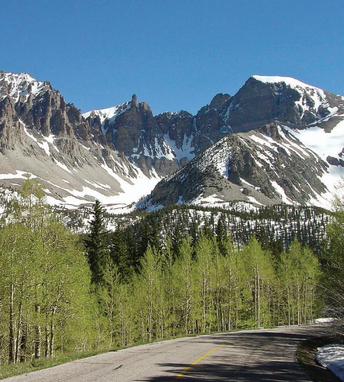
There is a glacier at Wheeler Peak, mostly underground and of an unknown depth.
PHOTO/NATIONAL PARKS SERVICE
Clues
Glacier could tell about Nevada’s future
it may surprise some residents of this desert state that is often afflicted with drought that there is a glacier in the Great Basin. It is located at the base of Wheeler Peak. And it’s feeling the heat.
Wheeler Peak, located in Great Basin National Park, reaches 13,063 feet, and the glacier is at about 11,500 feet. Much of the surrounding terrain— including the horn-like peak, nearby valleys and some lakes—was likely shaped by the glacier.
As a tourist attraction, the glacier is frustrating. It is not visible, and some people have drawn from this that it no longer exists. “It’s gone,” said a hiker to the Las Vegas Sun in 2015. Compared with the beautiful photos people are accustomed to seeing of ice glaciers, Wheeler Peak’s rock glacier can’t be photographed because it is essentially underground.
Scott Reinemann, geography professor at Ohio’s Miami University, and his colleagues are trying to get a better fix on the size of the glacier. It’s usually described vaguely as around 120,000 square feet in size
“The research group I am a part of has been researching in the Great Basin National Park for over a decade now,” he said. “We have more recently taken interest in mapping the area the rock glacier in the park covers.”
The National Park Service reports,, “The small glacier below Wheeler Peak has been incorrectly called an ice field. According to definition, an ice field is a vast body of ice, the union of several alpine glaciers. Ice fields are found today in Alaska and British Columbia. It has correctly been referred to as a rock glacier, however. A rock glacier is a lobe of angular boulders and cobbles that resembles an alpine glacier in outline and in its slow downslope movement. They are found in mountain ranges throughout the world. Inside a rock glacier, ice fills the spaces between the blocks. By freezing, thawing, and sagging, the ice works with gravity to provide the force that moves the rock glacier.”
The Wheeler Peak glacier is unusually far south for the western hemisphere. In addition to trying to measure the glacier, scientists have been using lakes to identify trends, and they think they can show a warming trend that began about four decades ago.
In a 2011 article for Park Science, Reinemann and five colleagues (Nathan A. Patrick, Gretchen M. Baker, David F. Porinchu, Bryan G. Mark, Jason E. Box) wrote, “Alpine and subalpine aquatic ecosystems are highly susceptible to direct and indirect effects of climate change, making them ideal study sites. We recovered a sediment core spanning the last 7,000 years from Stella Lake and a core of the last 100 years from Baker Lake in Great Basin National Park, Nevada, in 2005 and 2007. We examined the cores for subfossil chironomid (Insecta: Diptera: Chironomidae; i.e., midge) remains. The midge communities in the lakes underwent little compositional change through much of the 20th century; however, after 1980 a rapid lakespecific faunal turnover was observed.”
If the jargon is getting in the way, they are saying that around 1980 the insect life in the lakes began changing, with mites called midges that were adapted to cold dying out and warmeradapted types moving in.
The isolation and relatively unknown beauty of Great Basin National Park is an aid to the scientists, giving them a study setting that is largely undisturbed. Not always, though. This is from the same article, with emphasis added:
“We installed a micrologger network to record hourly observations of surface air temperature and humidity. ... The Lascar sensor network spans the full park elevation range (1,639–3,982 m or 5,377–13,063 ft) and includes sensors located at Baker (3,214 m/10,545 ft), Brown (2,976 m/9,764 ft), Stella (3,123 m/10,247 ft), and Teresa (3,132 m/10,276 ft) lakes. We analyzed data from autumn 2006 to
autumn 2010. Data recovery has been limited at the uppermost elevation at Wheeler Peak (3,982 m/13,063 ft) because of vandalism to the sensor. Throughout the park, annual air temperature ranges are extreme, approaching 50°C (90°F). The temperature ranges at the lakes were 40°C (72°F) or more. We find that temperature and humidity decrease with increasing elevation.”
There may be another value to the study of the glacier. Communities in the Great Basin rely on snow melt for their water supplies, and finding out more about melt at the glacier can provide more information on the implications of climate change for growth. While no one can draw broad conclusions yet, the glacier study may be useful down the road.
“At this point, it is hard to classify the degree of the melt at the rock glacier, as it is not your typical type of glacier you see in images of Alaska and the Sierra Nevada of California,” Reinemann said. “A rock glacier is by definition the last remnants of a once much larger glacier, and at this site that was probably a glacier thousands of years ago.”
The Natural Resources Conservation Service this week issued its latest report on snowpack: “February snowpack percentages are 26-50 percent of median across most of the region. Since January 1, snowpack percentages have continued a gradual decline and are now in the realm of recent drought years like 2012, 2014 and 2015. In the Lake Tahoe, Truckee, Carson and Walker basins, current snow amounts are slightly better than 2015, while for the Humboldt Basin and Eastern Nevada there is less snow than 2015. SNOTEL data indicates that the Upper Humboldt has its lowest February 1 snowpack since these stations were installed in
“It is hard to 1979. The Lower Humboldt is fourth lowest and Eastern classify the degree Nevada is third lowest. of the melt at the rock Based on history, other glacier.” years with snowpacks this low on February 1 were Scott Reinemann unable to recover to normal Scientist April 1 levels.” As for rainfall, “Monthly precipitation in January was 50-70 percent of average across most of northern Nevada and the eastern Sierra basins. As of February 1, water year to date precipitation since October 1 is below average for Nevada ranging from 44 percent in eastern Nevada to 83 percent in the Owyhee River Basin. This is the driest start to a water year in eastern Nevada since SNOTEL sites were installed in 1981. The Lake Tahoe, Truckee, Carson and Walker basins have received between 63-80 percent of average, while the Humboldt basin has had 74 percent.” Ω
Sticker trip