10 minute read
Capitol Region Natural Hazards Mitigation Plan


The Federal Emergency Management Agency (FEMA) defines target hazards as “facilities in either the public or private sector that provide essential products and services to the general public, are otherwise necessary to preserve the welfare and quality of life in the community, or fulfill important public safety, emergency response, and/or disaster recovery functions.” The NFPA further breaks these down into three risk categories for occupancies.
Advertisement
• High-Risk Occupancy: An occupancy that has a history of high frequency fires, high potential for loss of life or economic loss, or that has a low or moderate history of fires or loss of life, but the occupants have a high dependency on the built-in fire protection features or staff to assist in evacuation during a fire or other emergency.
• Moderate-Risk Occupancy: An occupancy that has a history of a moderate frequency of fires or a moderate potential for the loss of life or economic loss.
• Low-Risk Occupancy: An occupancy that has a history of low frequency of fires and minimal potential for life or economic loss.
Target hazards should be the focus of planning efforts for preparedness, resiliency, and recovery efforts. The impact of disruption to the normal operation of these critical facilities can compound other effects and impacts on a community. Therefore, response plans, drills, and training evolutions assist in familiarity and efficiency for emergency response operations at these facilities .
Critical Infrastructure
Critical infrastructure are assets, systems, and networks, whether physical or virtual, that are so vital to the community that their damage or destruction would have a debilitating effect.
Critical infrastructure in Southington includes the four Fire Stations, Police Department (Emergency Operations Center), Town Hall, Water Department, Water Pollution Control Facility, Municipal Center, Calendar House (Senior Center), eight elementary schools, two middle schools, and the high school.
Capitol Region Natural Hazards Mitigation Plan
The Capitol Region includes 38 municipalities around Connecticut’s State Capitol of Hartford. Through the Capitol Region Council of Governments, this region is active in planning for natural hazards mitigation to reduce their vulnerabilities to natural disasters and enable our communities to minimize losses and recover more effectively when disasters do occur.
The Capitol Region Council of Governments has prepared a multi-jurisdictional natural hazard mitigation plan that has been adopted by all member cities and towns and received FEMA’s approval on November 7, 2019. The plan will be in effect until November 6, 2024.
The purpose of this plan is to identify natural hazards likely to affect the Capitol Region and its nearly one million residents, assess vulnerabilities to these hazards, and set forth mitigation strategies that will reduce the loss of life and property, economic disruptions, and the cost of post‐disaster recovery for the region's communities. The impacts of these natural hazards were evaluated as well as the locations and groups of people particularly vulnerable to the effects of these hazards. Mitigation goals and strategies were developed at both the regional and local levels to reduce or prevent the damages to life and property that can result from these natural hazards. The Capitol Region Council of Governments, the Capitol Region Emergency Planning Committee, as well as local and other partners, are responsible for the implementation of the regional goals contained in this plan. Each participating municipality identified its own mitigation goals and strategies and assumes responsibility for the implementation of those measures.
This Hazard Mitigation Plan includes a very thorough community risk assessment. This section of the Southington Fire Department Master Plan summarizes the Hazard Assessments and Goals contained within the plan. ESCI will then correlate the Hazard Mitigation Plan with the Historical Service Demand and Performance of the Southington Fire Department.
The Capitol Region Hazard Mitigation Plan considers the following natural hazards that affect the region:
Figure 39. Natural Hazards Considered in the Capitol Region Hazard Mitigation Plan Natural Hazards
Dam Failure Drought Earthquake Flooding Forest and Wildland Fires Hurricanes and Tropical Storms Tornadoes and High Winds Severe Winter Storms
Within the Hazard Mitigation Plan, the impacts of these natural hazards were evaluated as well as the locations and groups of people particularly vulnerable to the effects of these hazards. Mitigation goals and strategies were developed at both the regional and local levels to reduce or prevent the damages to life and property that can result from these natural hazards. The Capitol Region Council of Governments and Capitol Region Emergency Planning Committee, in addition to local and other partners, are responsible for the implementation of the regional goals contained in this plan. Each participating municipality identified its own mitigation goals and strategies and assumes responsibility for the implementation of those measures.
To evaluate the impacts of these hazards on the region, the planning committee evaluated historical accounts of major storms and other events; examined flood insurance claims data and public assistance provided after federally declared disasters; analyzed demographic data and physical features; and used HAZUS‐ MH, a computer model, to estimate losses due to flooding, hurricanes, and earthquakes.
As part of the 2019 Plan Update, the planning committee and local and regional staff reexamined the goals, objectives, and strategic mitigation activities proposed in the 2014 Plan. The committee further considered the experience of the member communities with natural disasters of the last five years as well as input from the public and other stakeholders to develop a blueprint for better protecting the region during the next five years. This process culminated with each mitigation action being prioritized, and responsible agencies, potential funding sources, and time frames for implementing the projects identified. The adopted goal is to “Minimize the loss of life and property and economic disruptions that can result from natural hazards. The following four objectives and associated mitigation actions were developed in support of that goal.
Figure 40. Hazard Mitigation Plan Objectives and Mitigation Actions Hazard Mitigation Plan Objectives and Mitigation Actions
Objective 1: Improve stormwater management and groundwater recharge throughout the region to prevent increased flooding and lessen the effects of drought.
Mitigation Actions:
1.1 Encourage all municipalities in the region to adopt regulations that incorporate or refer to recommended practices from the most current Connecticut Stormwater Quality Manual, Connecticut Guidelines for Erosion and Sedimentation Control and, in particular, those that promote low-impact development and green infrastructure techniques. This will encourage development that is in harmony with natural drainage systems.
1.2 Foster improved understanding of the importance of stream management, maintenance of natural drainage channels, and use of green infrastructure practices among municipal staff, inland wetlands commissions, and planning and zoning commissions through education.
Objective 2: Assist municipalities in implementing hazard mitigation strategies.
Mitigation Actions:
2.1 Work with member municipalities to maintain this regional Natural Hazard Mitigation Plan with updates at least every 5 years.
2.2 Annually notify communities of the opportunities to apply for mitigation funds under the PDM and FMA programs and notify communities of HMGP opportunities as applicable. Provide letters of support when appropriate.
2.3 Incorporate additional natural hazard mitigation concerns into the regional Plan of Conservation and Development if it is updated in 2019‐2024, and provide specific instructions to municipalities to address natural hazard mitigation in local Plans of Conservation and Development as they are updated.
2.4 Encourage municipalities to participate in the National Flood Insurance Program's Community Rating System by hosting an information workshop.
Objective 3: Assist municipalities in minimizing risks associated with power disruptions.
Mitigation Actions:
3.1 Encourage the installation of generators at critical facilities and in developments serving the elderly or special need populations, or development of microgrids to serve the same purpose, through outreach and associated work with local officials to determine which facilities still do not possess standby power but require it.
Objective 4: Assist municipalities in minimizing risks associated with droughts.
Mitigation Actions:
4.1 Assist municipalities that do not currently have drought ordinances in enacting such ordinances to enable the enforcement of water conservation, and assist with messaging and notifications regarding droughts. These actions should be consistent with guidance resulting from implementation of the State Water Plan (2018) and the Coordinated Water System Plan (2018) as well as the updated Connecticut Drought Preparedness and Response Plan.
Each of the 38 municipalities in the Capitol Region also reassessed its goals, objectives, and strategic mitigation actions from the 2014 Plan and developed a new strategic course of action for the upcoming 5 years. While many are unique to the individual communities, there are commonalities among the actions proposed, and most communities have proposed a range of activities including public education and awareness; natural resource protection; plans, studies, and regulatory actions; structural projects and modifications to buildings, facilities, and infrastructure; as well as measures to improve preparedness and emergency response.
The Capitol Region Natural Hazards Mitigation Plan has identified the top three natural hazards that present a high risk to Southington are flooding, winter storms, and tropical storms/hurricanes. The plan summarizes the reasons for this prioritization as follows:
Flooding: Southington experiences recurrent flooding throughout Town, with localized flooding at known locations four to five times per year. As the town is relatively flat, floodwaters tend to recede slowly. Known flooding areas include West Main Street, Woodruff Street, Curtiss Street, North Main Street, Pratt Street, and River Street and the area along the Quinnipiac Reviver are prone flooding.
Winter Storms: Ice and snow make roads impassable and down tree limbs, disrupting utility service. People can become stranded in their homes, potentially without heat or power. Higher elevations may be at a greater risk. Following Winter Storm Alfred in late October 2011, power was lost for nine days to most customers, with some power not restored for two weeks. Many restaurants did not have backup power and there was significant spoilage. A few areas, such as those near large fields, are prone to drifting snow. Following the January 2013 blizzard, snow removal was the primary financial impact. Two commercial roofs were reported collapsed due to this event. No significant impacts due to icing have been observed in recent years. Ice jam flooding tends to be localized. Areas on the east side of Town near the reservoir, and open areas with higher elevation, generally have icing during winters.
Tropical Storms / Hurricanes: Following Tropical Storm Irene in 2011, power was lost for approximately one day in Southington, although some residents lost power for up to five days. A maximum of 3,854 customers were without power. Damages during Tropical Storm Sandy were relatively minimal.
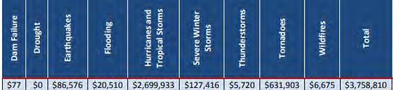
Average Annualized Loss figures are useful tools for comparison of the risks faced from different hazards with different likelihoods of occurring in a given time period. Within the Capitol Region Hazard Mitigation Plan, dam failure, drought, tornado, and wildfire losses were sourced from the 2014 Connecticut Natural Hazard Mitigation Plan Update, with dam failure data supplemented by the National Performance of Dams Program and the Connecticut Department of Energy & Environmental Protection. Earthquake and hurricane losses were calculated in HAZUS-MH. Losses for flooding came from NFIP claims, for winter storms from Public Assistance Reimbursements, and for thunderstorms from the NCEI database. These are presented in the table below in dollars per year.
Figure 41. Average Annualized Losses, Southington11
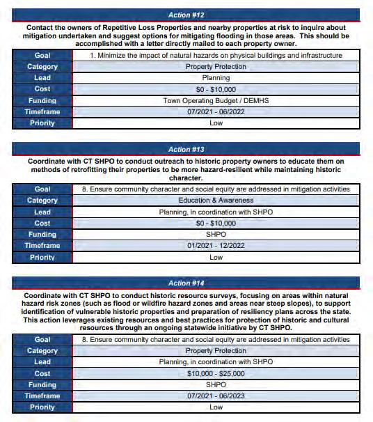
The Town of Southington’s top six mitigation strategies, in order of priority, are listed below. Southington has two top priorities and two priorities listed third.
Tied for Priority 1: Natural Resources and Protection; Structural Projects
Tied for Priority 3: Prevention; Property Protection
Priority 5: Education and Awareness
Priority 6: Preparedness and Emergency Response
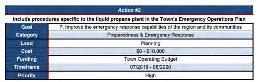
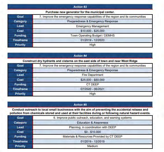
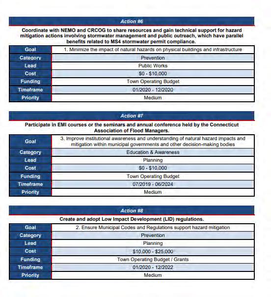
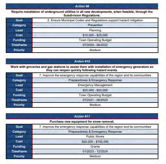
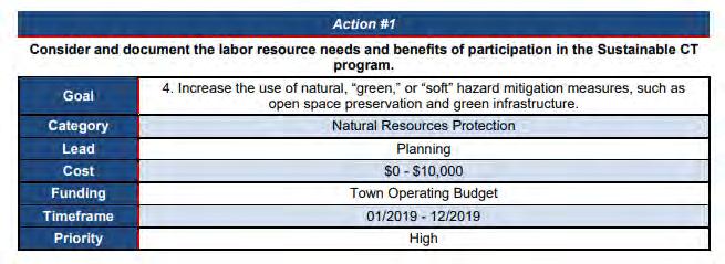
The Town of Southington has proposed to initiate 17 mitigation strategies during the 5-year period of the Capitol Region Hazard Mitigation Plan. They are listed below in order starting with the highest priority based on FEMA Guidelines.
Figure 42. 2019-2024 Mitigation Strategies12
11 https://crcog.org/wp-content/uploads/2019/12/Southington.pdf 12 https://crcog.org/wp-content/uploads/2019/12/Southington.pdf