9 minute read
Surveying through All Stages


PBH have a long history in railway surveying and have always ensured that our teams have expertise in both innovative surveying techniques alongside track safety training.
This has enabled PBH to expand our survey team to include COSS, ES, SWL1, SWL2 and Protection Controllers, all supported by five experienced Safe Work Planners providing quality access planning. This experience enables us to internally plan, manage and safely deliver surveys to support tight programme constraints in all parts of the UK.
Planning
With extensive knowledge of track access planning requirements, our RISQS accredited planning team are fully trained and competent with the expertise needed to support delivery of all workstreams safely. The knowledge and experience of working nationally allows our team of professionally qualified staff to provide a full spectrum of planning support services. We can support the delivery of programmes of all sizes in all corners of the UK.
We have the capability to plan long and short-term track access using all resources available to keep your programme on track. PBH Planning also pride ourselves on the production of quality safety critical paperwork compliant with NR/L2/OHS 019 to ensure the safe delivery of all work on site.
The wealth of knowledge and experience within our team allows us to offer bespoke services enabling the planning and management of tailor-made programmes to suit your requirements and ensure a service of the highest standard. We can also look at alternative approaches to help deliver challenging programmes. PBH Planning has over 40 years combined experience working with Network Rail Maintenance, Track Renewals and many principal contractors and we have helped to deliver many programmes on behalf of all of our clients safely and on time.
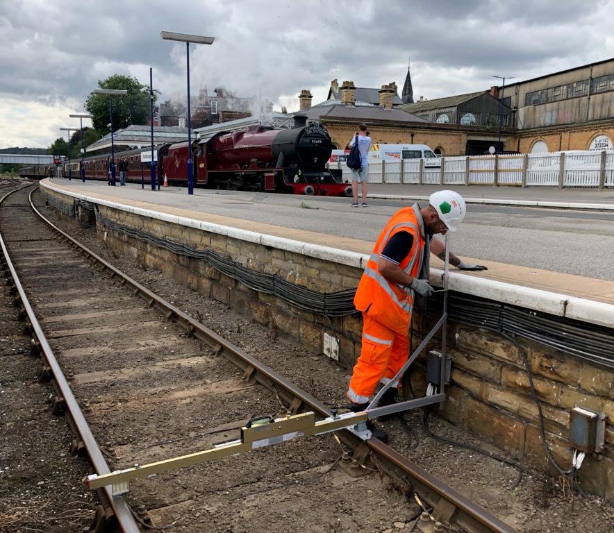
Plain Line Surveys
PBH have surveyed plain-line sites across the UK supplying data to many of the principal contractors. Each PBH surveyor has extensive componentry knowledge which, coupled with modern surveying techniques, ensures a final deliverable that meets and often exceeds the current Network Rail standards.
S&C Surveys
Complex S&C surveys require the highest degree of knowledge and understanding of the permanent way infrastructure. The PBH team is highly skilled and trained in carrying out S&C surveys, with many years of experience of working closely with our in-house design teams to undertake these projects.
Our survey teams work efficiently with single-operator robotic instrumentation and mass data capture systems to ensure that track access is utilised in the most efficient way possible.
Gauging Surveys
PBH Surveys provide structure gauge clearance surveys in compliance with Network Rail Standard NR/L2/TRK/3203.
To ensure the safe passage of trains, surveys are carried out as part of the suite of gauging standards which manage risk relating to gauging compatibility, structural clearances, passing clearances and calculation of stepping clearances on the infrastructure.
All gauging surveys are carried out with the latest compliant equipment utilising track mounted Abtus Routescans, Balfour Beatty Lasersweep, Robel Platform Gages and track mounted laser scanners on Track Measuring devices (TMDs). Gauging surveys include rail geometry collected from both TMDs and conventional topographical methods.
The Permanent Way Design team within PBH Rail offers full clearance analysis through ClearRoute providing Network Rail National Gauging Database reports.
Laser Scanning Surveys
When surveying some of the largest and most complex structures on the network, PBH harness the benefits of laser scanning to ensure a more robust deliverable.
Some of the benefits of laser scanning include:
• Entire and accurate dimensions
• A repeatable 3D environment allowing for easy navigation
• Geo-referenced information which can be linked to design projects
• Provision of an accurate basis to build infrastructure models
• Safe non-contact data capture even in difficult or dangerous places to access
• A ‘Capture-All/Capture-Once’ methodology to reduce the need for site revisits
• An insurance policy against future scope creep – the data is there even if not required at the project outset
Utilities
PBH Surveys offer PAS128 compliant Utilities Surveys to allow designers to know what is potentially beneath them when preparing and working on a site. This can help mitigate potential issues when breaking ground or positioning large plant and machinery during construction works, which may cause damage to services passing through the site.
PBH use the latest detection techniques including Electromagnetic Detection, signal induced threading and Ground Penetrating Radar (GPR) to locate utilities.
Monitoring
At PBH, we provide a range of monitoring services which can be tailored to suit the requirements of our client. Utilising a range of techniques, we are currently involved in monitoring track, structures and embankments on the railway infrastructure throughout the UK. The techniques deployed on these projects range from traditional track monitoring using retro reflective targets and total stations, to automatic wireless mesh networks which can deliver movement information in real time via an online web portal.
Our tender stage consultation services aid our clients to consider monitoring provisions and solutions at the procurement and bid stages.
The PBH Monitoring team have close working relationships with several leading global suppliers of monitoring equipment to provide monitoring solutions through all stages of construction and maintenance.
UAV
UAV surveys collect data using small remotely piloted aircraft systems, otherwise known as unmanned aerial vehicles (UAVs). PBH UAV operational platforms can be legally flown in wind speeds up to 20mph, and at heights up to 400 feet.
UAVs will be operated within line of sight of the pilot, or within 500 metres, whichever is the lesser of the two. PBH Surveys operate UAVs under a Permission for Commercial Operation (PfCO) with the Civil Aviation Authority (CAA), with permission to operate multi-rotors (≤20kg).
The platforms currently utilised to carry out work are either:
A. A multi rotor UAV with a payload operating a 100mp camera, or B. A multi roto UAV with a 20mp camera/HD .mp4 video recorded
UAV Surveys are a fantastic way to record orthomosaics and detailed 3D models of areas where poor quality, outdated or limited data is available.
Rail depots
Depots, although part of the railway infrastructure often pose a different set of challenges. Some examples of this would be:
• Typically, depots are open when the railway network is closed
• Generally, tracks are in a poor condition as maintenance is reduced due to the low speeds permitted
• Often depots have a collection of varying materials and S&C ages which requires a wealth of experience when trying to identify
Some depots have stabled stock that cannot be moved - PBH are well versed in selecting appropriate survey techniques to minimise the problems this may cause for a complete survey deliverable.
Depots also require staff to communicate with depot managers to agree local safeworking arrangements on closed/open lines within the depot. This requires a clear understanding of depot layouts to work in close proximity to stabled trains and ensure minimal gaps are left in survey data.
Deliverables
PBH Surveys can deliver outputs directly tailored to client requirements:
• ‘Traditional’ Linework/linestyles 2D Drawings – dgn/.dwg
• ‘Traditional’ 3D Wireframe Drawings –.dgn/.dwg
• ‘Simple Hybrid’ 3D Wireframes/ Solid Models – combining traditional track surveys with 3D Solid models of complicated structures - dgn/. dwg/.rvt/.msh
• ‘Complex Hybrid’ 3D Wireframes/ Solid Models – Full solid models of all infrastructure supplemented with traditional topographic surveys - dgn/. dwg/.rvt/.msh
• Total 3D Solid Models – No traditional Linework. - dgn/.dwg/.rvt/.msh
• All deliverables can be tailored to suit time/cost budgets.
• Outline Detail – Building Shapes/ groundforms – representative components.
• Medium Detail – Building Shapes/ Features – basic componentry accurately depicted.
• High Detail – WYSIWYM “What You See Is What You Model” Accurate depictions of all features required in specification.
• Rendered High Detail – Photorealistic Models used for heritage grade/planning applications etc
Case studies
Below are some examples of different projects that PBH Rail has worked on.
Kilsby Tunnel
Network Rail realised that the Covid-19 pandemic would cause a reduced train service. As a result, a potential blockade could be secured on the West Coast Mainline covering Kilsby Tunnel to undertake the renewal of 800 yards of drainage and 870 yards of track. PBH got the call ten days before the blockade was due to start, requesting a full survey and design. PBH mobilised survey resources to complete the survey over one weekend night shift, processed the data and delivered to the design team within three days. The design team turned the design around within a week in time for the renewal to start.
Central Rail Systems Alliance S&C
PBH is delivering detailed S&C surveys for the CRSA Alliance across multiple regions. PBH undertake all access planning, paperwork and Safety Critical Staff for the client to ensure efficient delivery of both surveys and client design. A large percentage of PBH’s staff have extensive experience in this type of work which is demonstrated by our capacity to supply the large amount of survey data that is required when renewing S&C. Our regional based survey teams and internal planning resource services allow any changes to the delivery programme to be actioned quickly and safely.
Central Rail Systems Alliance Plain Line Workbank and Network Rail Workbank
Through CP6, PBH Rail is delivering Plain Line surveys across LNE, LNW, Anglia and Scotland for CRSA and Network Rail Works Delivery. This results in an annual combined workbank of circa 300 sites, ranging from Plain Line, Gauge Clearance, Drainage and S&C. Our in-house Planning, Survey, Track Design and OLE Design allows one point of contact for the client which ensures the demanding delivery timescales are met.
Monitoring
PBH are regularly commissioned to undertake monitoring across a variety of projects. We are experienced in the use of remote web-based monitoring and conventional monitoring. Projects range from the monitoring of tracks, buildings, embankments and railway infrastructure such as tunnels, bridges and arches. PBH have developed bespoke monitoring solutions to meet the client’s needs.
Depot
Newton Heath was surveyed by PBH due to various concerns raised by the Depot Manager regarding the condition of the structure, therefore a survey was required to assess what repairs were needed to be undertaken. We installed and coordinated a new grid tied to Snake Grid TPEN11 utilising six-hour GNSS observations as per the Northern Programmes standard.
A mix of traditional topographical survey, UAV survey and terrestrial laser scanning was undertaken in order to deliver this project in the most efficient manner. The final deliverables were delivered to LOD300 standard along with our usual 3D dgn, registered point cloud and full NR3100 standard survey report. A flythrough of the site was created in order to assist the client with their design from the comfort of their own desk, minimising the need for further site walkouts.
Tel: 07487 717 900
Email: Matt.Chilton@pbhrail.com
Visit: www.pbhrail.com