
Parking Reduction Strategy
2023- 2028

For Flemington-Racecourse Road


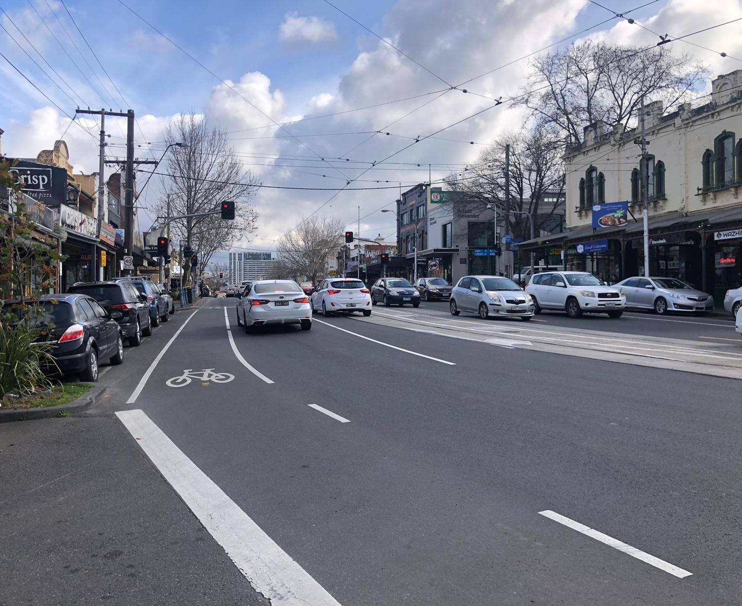
Picture taken at Racecourse Road (Zellmann, 2023)
By Rachana Ravindra Patil
Executive Summary
In consideration to current scenario of Flemington-Racecourse Road’s parking challenges, Parking Reduction Strategy plan of 2023-28 is proposed to implement a multifaceted approach that reduces on-street parking, promotes active transport modes, optimizes reclaimed parking areas, and establishes efficient community engagement strategies Based on relevant background literature, on-site analysis report and policy evaluation report, strategic targets and actions are derived for parking reduction. To measure the progress of goals through the 5-year time frame, monitoring and evaluation framework is developed for this strategic plan.
1. Relevant Data and Background
Flemington-Racecourse Road is one of Melbourne’s Major Activity Centre (MAC) of the Western Metro Region, which is projected to intensify into the development of a diverse mixed-use location that will attract investment, create job opportunities, and strengthen the Public Transit Network (PTN) (Plan Melbourne, 2017). The intensification in MAC areas such as Racecourse Road will upsurge car parking spaces that take up the lead of parking overlay policies and generate long-term problems related to the quality of pedestrian walking areas (Dovey and Symons, 2014).
Goodman et al (2016) states that while planning for a sustainable city there was no positive link found between car parking provision and the level of engagement by the pedestrian within the street area. And considering parking act as a significant link between land-use and transport (Goodman et al, 2016), yet its negative effects are overlooked in the MAC of Racecourse Road (Racecourse Road Site Analysis report, 2023). Therefore, to overcome such issues, there is a need for Parking Reduction strategy for Racecourse Road that will not only address the parking issues related to MAC, but also establish measures for a more environmentally sustainable and pedestrian accessible focused outcomes.
Following (Fig 1) is the selected study area of SA1s for Parking Reduction Strategy for Racecourse Road,
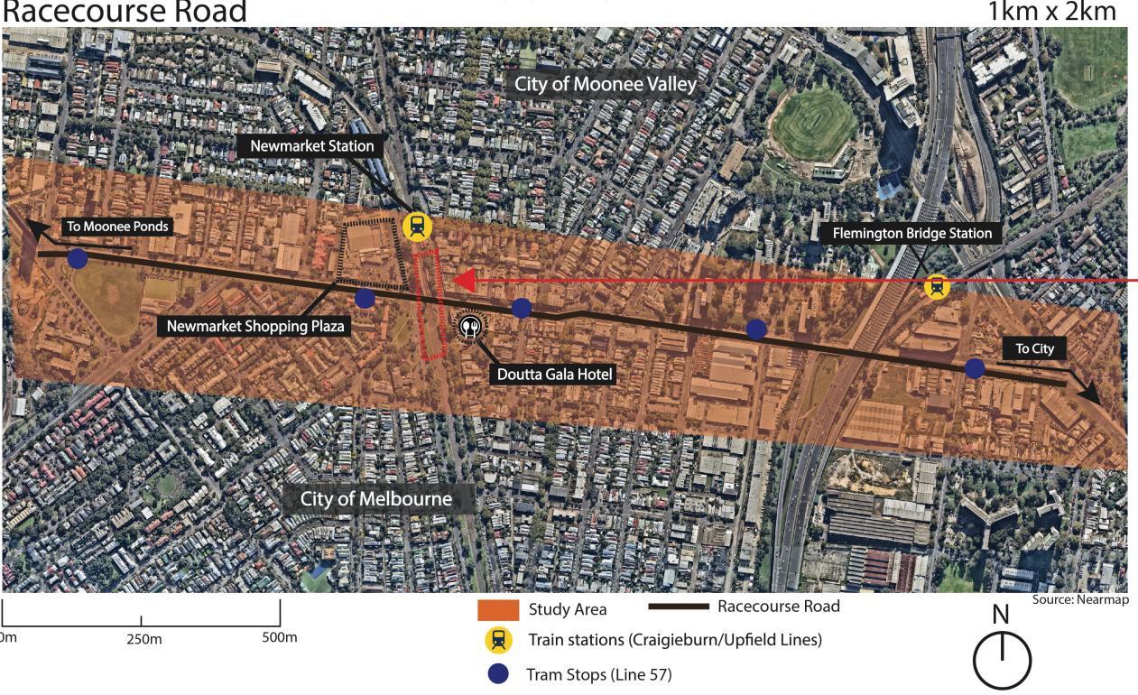
Fig 1: Study area for Flemington-Racecourse Road Parking Reduction Strategy, (Source: Nearmap, 2023; Racecourse Road Site Analysis report, 2023)
The main characteristics that make it harder to find effective actions for parking reduction issues of Racecourse Road in comparison to other parts of Melbourne are as follows,
1. Neighborhood specific;
• Parking congestion, which hampers the traffic flow during peak working hours, affects pedestrian safety (Racecourse Road Site Analysis report, 2023),
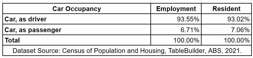
• The mixed-use land usage which combines various types of daily activities creating diverse needs of parking (Xiao et al, 2023), the car parking occupancy ratio (Refer Fig 2) shows the relationship between land-use of employment and residential areas.
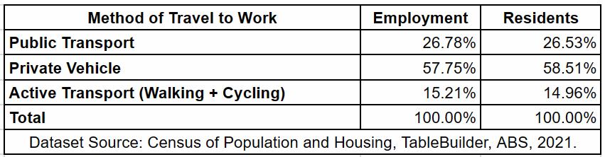
• The existing trip generation method of travel to work data shows that, public transport inaccessibility affects the parking habits, which leads to more car-dependency and low rate of public transport and active transport (walking and cycling) methods (Xiao et al, 2023), Refer Fig 3
• Car parking creates a disruptive interface for streetscape in Racecourse Road (Refer Fig 4, 5), which does not encourage high permeability of pedestrian walking (Dovey and Pafka, 2020), also does not regard biking infrastructure and its safety, especially for such MAC area which aims to be a 20-min walkable neighborhood (Plan Melbourne, 2019)
Fig 2: Car Occupancy percentage for Racecourse Road SA1 areas, ABS, 2021
Fig 3: Trip Generation Assessment for Racecourse Road SA1 areas, ABS, 2021
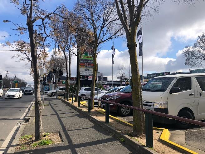
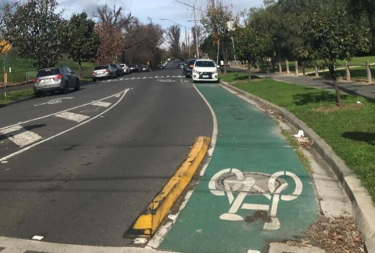
3, 4: Issues caused due to car-parking for pedestrian walking interface and biking infrastructure, Pictures taken on site (Racecourse Road Site Analysis report, 2023)
• Events occurring at Flemington-Racecourse such as Melbourne Cup etc., which creates eventbased congestion between high demand for parking spaces and high foot traffic upto maximum 73,816 which was recorded after Covid-19 wave (Victoria Racing Club, 2023), historically also more than 100,000 crowd has been recorded (Cusack and Digance, 2009).
2. Policy specific;
• City of Melbourne (CoM) Council Plan 2021-25 highlights ‘Safety and Wellbeing’ along with ‘Access and affordability’ as two of the main strategic objectives with the targets of reducing car parking congestion and increasing public transport on general terms. Such generalization shows a lack of integration of city level policies with Plan Melbourne 20172050 directions for MACs (Racecourse Road Policy Analysis Report, 2023). This gap demands for specific targets that will support in reduction of car parking.
• Correspondingly, City of Moonee Valley Council (CoMV) Plan 2021-25 in its strategy for ‘A Healthy City: Connected C1’ remarks for a better accessibility and sustainable options of transport but it does not integrate with local Moonee Valley 2040 (MV2040) ‘Strategic Direction 10, Objective 10.1’ of expanding the frequency options of public transport (Racecourse Road Policy Analysis Report, 2023). Such gap signifies the need for collaboration between city and local level targets and actions which will consider design codes and flexibility of parking options to achieve strategic goals. (Hurlimann et al, 2020).
• The Moonee Ponds Creek Strategic Opportunities Plan (MPCSO) 2019 acknowledges the intensification of public transport for Racecourse Road is needed due to its central reach with Dynon Road which will affect the pedestrian circulation, but it does not specify reduction of parking spaces which is one of the main factors of pedestrian walkability disruption (Dovey and Pafka, 2020).
• From the overall policy evaluation of integration between state, city, and local level strategy plans (Racecourse Road Policy Analysis Report, 2023), it is apparent that
Fig
Racecourse Road does not have a site-specific parking strategy and its lack of alliance between CoM & CoMV council plans, local strategy plans (MPSCO, MV2040) and Plan Melbourne 2017-2050.
• As Racecourse Road combines of diverse land-use zones such as R1Z, MUZ, B1Z, B2Z, PPRZ, GRZ1 with Parking Overlay (PO) on the whole area, the requirement of minimum parking rate is used with no regards to the neighborhood character for on street parking. Also, as per Victoria Planning Provision of CoM and CoMV: 52.06 Clause of car parking state that, the purpose of car-park should not diversely affect the amenity of locality as well as the car parking location and design should not create unsafe environment for users nor hinder the accessibility of the users.
• The above policies seem to be neglected in the current parking layout of Racecourse Road which is both unsafe as well as causes disruption in accessibility (Racecourse Road Site Analysis report, 2023),
Reducing car-parking matters for the Racecourse because it is not only a developing MAC but also projected to become a 20-min walkable neighborhood (Plan Melbourne, 2017), which demands for actions that will provoke a behavioral change in the reduction of on-street car parking upto a substantial rate in consideration with the neighborhood characteristics and promote pedestrian permeability (Xiao et al, 2023; Dovey and Pafka, 2020).
For the parking reduction strategy, it is vital to have an upstream thinking that allows consistency and coherency between goals and actions, which leads to effective partnership between various actors that are involved in all levels of government (Lowe et al, 2015). To achieve this collaboration, identification of specific parking indicators such as car parking design, car occupancy rates, travel times and trip generation of that locality needs to be considered to promote measures for reducing on-street parking (Lowe et al, 2015).
It is likely high that these measures, if developed will work in Racecourse Road considering the proximity of this MAC with the increasing population of overall Melbourne (5.2 million to 10.3 million by 2051, Victoria in Future 2023) will almost double from 2023 to 2051.
2. Community Engagement and Outcomes
2.1. Current Parking Community Consultation for CoM in relation to Racecourse Road.
CoM’s Participate Melbourne, acknowledges community feedback for parking through workshops and online surveys for the improvement of parking, yet this engagement is only with respect to CBD and its immediate areas. The approach to managing parking is in more towards economic growth factor with only general considerations to pedestrian well-being (Participate Melbourne, 2023). As stated by Aspen (2013) such engagement which largely aims for economic growth focus more on the outside world attraction towards the city with such generalized changes, rather than a city governance focusing on its citizens.
2.2. Techniques for Parking Reduction Community engagement
Parking conflicts, as Litman (2016) observes are commonly faced by every government actor such as planners, designers, operators, and other officials, because it is often related to solutions related to management in making parking planning more compact for better aka smart growth. For management solutions such as reduction, involvement of users that use active transport and private vehicle both needs to happen, the involvement of diverse community users will reduce homogenization of participation and its outcomes, which will also allow a broader scale understanding for adapting strategies (Legacy et al, 2023).
Reducing car parking may address to problems related to pedestrian safety, traffic congestion and active transport, but some broader community strategic objectives may contradict with it, such as parking for users when it is necessary (Litman, 2016). In consideration with such contradictions, proposing a 100% Parking reduction is not tangible.
Another technique such as shared parking awareness focus groups will promote in diminishing parking footprint in Racecourse Road, by allowing a more compact use of land, promote walking and shortening trips through private cars (Sundquist et al., 2018)
2.3. Expected Actions for Parking Reduction through community engagement
2.2.1. Developing awareness of need and benefits to the larger community of Racecourse Road
The outcome of this action will be community group meetings held to make residents aware about benefits related to health, safety, sustainable accessibility, active transport in relation to parking mitigation (Sundquist et al., 2018)
2.2.2. Conducting constant community engagement audits for feedback implementation
The outcome of constant community engagement held with all types of users, help in funneling feedback that can be synthesized to specific actions and amended when need to (Lowe et al, 2015).
2.2.3. Analyzing process of decision-making transparency with strategy implementation and community
This outcome will gather statistical data of parking reduction implementation, which will show transparency of local councils’ decisions that can help in increasing larger community engagement (Scharenguivel, 2023).
2.2.4. Making sure that all types of voices are heard while gathering feedback
Smaller focus groups meetings can help in developing deeper understanding of specific issues, which sometimes is not addressed in larger community engagement due issues of power dynamics (Legacy et al, 2023).
3. Visions and Goals
3.1. Vision:
The vision for Flemington-Racecourse Road is to create an accessible, safe, and pedestrianfriendly streets by reducing on-street car parking footprint.
The Racecourse Road community aspires to adapt active transport routes, making pathways more walkable by aiming to diminish parking land-use to allow 20-min neighborhood character to bloom (Principle 5: Living Locally – 20 min neighborhoods, Plan Melbourne, 2017-2050). And in consideration with Flemington-Racecourse Road being a MAC area, as per Plan Melbourne 20172050, ‘Principle 3: A city of centers linked to regional Victoria’ policies, the land-use planning for car parking areas will be inconsideration with future public transport network intensification. Principle 3 also directs vision for a more community engagement-based process for feedback incorporation into the planning schemes (Plan Melbourne, 2017-2050).
3.2. Goals:
3.2.1. Reduction of 50% on-street parking spaces on Racecourse Road
Based on trip generation assessment and private car occupancy rate being more than 90% highlights that the accessibility from Racecourse Road is more reliable on cars (ABS, 2021). In consideration with MAC directions of Plan Melbourne 2017-2050, intensification of PTN will lead
to loss of half (50%) of the on-street parking as the precinct develops (20-min neighborhoods, Plan Melbourne 2017-2050; Arden Precinct Parking Plan, 2021).
3.2.2. Increase in 40% usage of active transport modes
As MAC areas will be Smart Growth oriented, upto 60% of public transport will be used with a hike in 40% of active transport such as walking with 30% and biking with 10% (Plan Melbourne 2017-2050; Bicycle Plan 2016-2020; 20-min neighborhoods, Plan Melbourne 2017-2050).
3.2.3. Reclamation of 50% parking areas to enhance streetscape
The reclaimed parking areas will be developed to create a positive link between pedestrian pathway and street, which allows active interfaces to be formed to promote walkability, social activities, and safety for public street infrastructure (Dovey and Pafka, 2020; Goodman, 2016).
3.2.4. Reduction in traffic congestion by 50% for Racecourse Road
Based on the car occupancy rate (ABS, 2021) and Racecourse Road site analysis report (2023) parking causes congestion in traffic flow, for which improved active transport options will quantify traffic congestion based on reduction in usage of parking spaces (Litman, 2016).
3.2.5. Increase in 30% usage of shared parking
Based on Litman’s study of comprehensive management plan for shared parking spaces, employment car park space requirement can be reduced to 70% by implementing a trip-reduction program that promotes shared spaces rather than reserved spaces. For example, if 100 employees can share upto 60-80 car parking spaces (Litman, 2016).
3.3. Time frame and its justification
As the goals show integration with policies related to other plans that range from 5 years, as well as in consideration with council 5-year plans, the actions can be sorted to be mostly short-term actions (STA) (Silva et al, 2012). It is also acknowledged that Plan Melbourne 2017–2050-time frame cannot be fully considered for the timeframe selection of Parking Reduction Strategy, therefore goals are limited to percentages which are achievable in the time frame of five years term And this 5-year term is sub divided into short term, medium term, and long term for a more detailed time frame (Silva et al, 2012).
4. Proposed Actions
4.1. Specified actions table with consideration to time frame of a 5-year plan:
3.2.1. Reduction of 50% onstreet parking spaces on Racecourse Road
1. Implementing park and walk policy to encourage peripheral parking at the edge of Racecourse Road (Milosavljević and Simićević, 2019)
2. Establish park and ride system to endorse visitors to park on the periphery and use alternative travel modes to reduce need for on-street parking (Milosavljević and Simićević, 2019)
3. Implementing a permit system with reduced allocation to promote alternate mode of travel (Willson, 2018)
4. Introducing parking with timelimited pricing system for visitors during seasonal events at Flemington Racecourse (Milosavljević and Simićević, 2019)
5. Implementing parking pricing that aims to promote alternative transport. Introducing such pricing should consider parking price ratio with transit fare, which helps in governing distribution of other transport modes that visitors can use to reach Racecourse Road (Simićević et al, 2013)

3.2.2.
Increase in 40% usage of active transport modes
1. Coducting learning campaigns of health and environment benefits through collaborating with community engagement strategies to promote active transport (Scheepers et al, 2014)
2. Collaborating with active transport stakeholders and local communities to organize workshops that endorse weekly pedestrian pathway walks or biking (Scheepers et al, 2014)
3. Collaboration of communities with councils to improve activeness of streetscape interfaces that will make walking activities more permeable (Dovey and Pafka, 2020)
4. Providing subsidies for bicycle purchases in collaboration with biking stakeholders to encourage shift in travel mode (Scheepers et al, 2014)
3.2.3.
Reclamation of 50% parking areas to enhance streetscape
1. Implementing conversion of impervious reclaimed parking spaces to natural ground spaces (Goodman et al, 2014)
2. Implementing design guidelines for reclaimed parking spaces that maximize accessibility for active transport network (Dhanani and Vaughan, 2016)
3. Collaborating with urban designers and councils to generate streetscape models that are safe and user-friendly (Dhanani and Vaughan, 2016)
4. Improving Racecourse Road landscaping aspects by beautifying reclaimed spaces (Dhanani and Vaughan, 2016)
3.2.4.
Reduction in traffic congestion by 50% for Racecourse Road
1. Upgrading the current traffic signaling, crossing intersection layouts for a time equitable management of rush hour traffic (Litman, 2016).
2. Improving density of connection between public transport and pedestrian pathways to improve accessibility and reduce congestion (Litman, 2023)
3. Implementing multimodal accessibility modeling for Racecourse Road that evaluates accessibility based on services and activities to improve other travel modes (Litman, 2023)
4. Developing integrated program of public transit program and travel mode shift through community workshops (Simićević et al, 2013)
3.2.5.
Increase in 30% usage of shared parking
1. Developing shared parking allocation programs through collaboration with commercial stakeholders to endorse smart parking (Litman, 2023)
2. Collaborating with local businesses through community meetings to adapt smart shared parking during seasonal events (Milosavljević and Simićević, 2019)
3. Implementing low pricing for shared parking spaces that promotes reduction in individual parking (Milosavljević and Simićević, 2019)
5. Alignment of relevant strategies
5.1. Alignment of strategies table
Strategic Goals Allies How will it support in achieving goals? 3.2 1. Reduction of 50% on-street parking spaces on Racecourse Road
City of Melbourne
Bicycle Plan 2016-2020
3.2.2. Increase in 40% usage of active transport modes
City of Moonee Valley –
Walking & Cycling
CoMV- Community
Vision, Council Plan and Health Plan 2021-2025
City of Moonee Valley –
Walking & Cycling
City of Melbourne
Bicycle Plan 2016-2020
3.2.3. Reclamation of 50% parking areas to enhance streetscape
MV2040 Action Plan –Green
Bicycle plan Targets encourage a change in increasing active transport mode shift by 30 % for walking and 10 % for biking which will support Goal 3.2.1. Action 1, Action 2, Action 3.
CoMV Walking & Cycling programs aims encourages walking and biking instead of car transport.
The strategic indicator of CoMV Health plan ‘A healthy city: Connected’ endorses directions to increasing accessibility of active transport in relation to Goal 3.2.2. Action 1, Action 4.
CoM Bicycle Plan’s 40% active transport usage displays full support for achieving Goal 3.2.2.
MV2040 plan goal for ‘A healthy city’ that is strengthened by generation of beautiful streetscape areas to make neighborhood lively, this supports Action 1, Action 3, Action 4 of Goal 3.2.3.
3.2.4. Reduction in traffic congestion by 50% for Racecourse Road
Participate Melbourne –Streetscape Improvements Program
City of Melbourne
Bicycle Plan 2016-2020
Streetscape program aims to ensure design of streets is based on safety, user-friendly and future growth, which supports Action 3 of Goal 3.2.3.
CoM Bicycle plan targets emphasize on shifting of commuter behavior to shift travel mode from private cars to active transport which supports Goal 3.2.4. Action 3, Action 4.
3.2.5. Increase in 30% usage of shared parking No Ally N/A
5.2. Differences of strategic directions with relation to Parking Reduction Strategy for Racecourse Road:
• MV2040 Action Plan of Community Facilities (2021) envisions additional on-street parking spaces (p. 21) for its community centers which does not align with Parking Reduction Strategy Goal 3.2.5. Action 2, which proposes adaptation of smart shared parking spaces for temporary events happening at community spaces (Milosavljević and Simićević, 2019).
• CoM Parking and Kerbside Management Plan (2023) proposes on-street parking for residents and accessibility to parking spaces with proximity to employment sector crowd, which is totally opposing to Parking Reduction Strategy Goal 3.2.1. Actions that aim to endorse permit system to reduce allocation of parking spots and allow use of alternative travel mode (Willson, 2018)
6. Monitoring and Evaluation Plan
To analyses if actions are being implemented as per decided time frame, it is vital to establish a comprehensive evaluation framework for monitoring Parking reduction strategy indicators (Litman, 2016). This framework will measure the progress of actions and are they completed by expected period as stated in 4.1. Specified Actions table.
For establishing the evaluation framework, it is also important to decide precise performative indicators that will support in giving an apt quantity of achieved goals.
Following table shows identified Parking Reduction Indicators that will be used for monitoring with evaluation criteria based on Litman (2016; 2023), (Dhanani and Vaughan, 2016), (Milosavljević and Simićević, 2019) studies of parking management;
Strategic Goals
3.2.1.
Reduction of 50% on-street parking spaces on Racecourse Road
3.2.2. Increase in 40% usage of active transport modes
Monitoring Indicators Evaluation Criteria
Number of on-street parking spaces
Utilization of off-street parking spaces
Rate of walking permeability on Racecourse Road
Rate of biking on Racecourse Road
Decrease of car occupancy on street parking upto 50% from baseline count
Increase by 50% from current off-street occupancy rate
Increase by 40% for both active transports over the course of short to mid term time frame, as it is largely a community engagement approach.
3.2.3. Reclamation of 50% parking areas to enhance streetscape
3.2.4. Reduction in traffic congestion by 50% for Racecourse Road
Area (sq. m.) reclaimed for streetscape
Rate of walking permeability after streetscape enhancement
Frequency analysis of average Traffic flow before and after parking reduction
Volume of Traffic during Peak hour
Measuring reclaimed parking areas for streetscape revitalization
Increase in 30% walking rate based on specifications of 3.2.2. Goal
Increase by 50% from the previous frequency pf traffic flow.
Data of Traffic count during peak hour comparison with previous data before parking reduction
3.2.5. Increase in 30% usage of shared parking
Rate of shared parking usage Increase in 30% usage of shared parking spaces by collecting data for overall participated commercial/local business stakeholders after major events.
7. References
Aspen, J. (2015). Oslo–The triumph of zombie urbanism. In Shaping the city (pp. 182-200). Routledge
Arden Precinct Parking Plan VPA. (2018, July 23). https://vpa.vic.gov.au/project/arden/, https://vpa.vic.gov.au/project/arden/
Australian Bureau of Statistics. (n.d.). Retrieved November 1, 2023, from https://www.abs.gov.au/statistics
City of Melbourne. (2019). Moonee Ponds Creek Strategic Opportunities Plan.
City of Melbourne. (2021a). City of Melbourne, City of Possibility: Council Plan 2021-2025.
City of Moonee Valley. (2018). MV2040 strategy. June, 1–106.
City of Moonee Valley. (2021). Community Vision, Council Plan and Health Plan 2021-2025.
52.06 CAR PARKING MOONEE VALLEY Planning Scheme Ordinance. (n.d.). Retrieved October 31, 2023, from https://planningschemes.app.planning.vic.gov.au/MOONEE%20VALLEY/ordinance/52.06
Cusack, C. M., & Digance, J. (2009). The Melbourne Cup: Australian identity and secular pilgrimage. Sport in Society, 12(7), 876–889. https://doi.org/10.1080/17430430903053109
Community consultation | Parking and Kerbside Management Plan. (n.d.). Participate Melbourne. Retrieved October 31, 2023, from https://participate.melbourne.vic.gov.au/parkingplan/community-consultation
Dhanani, A., & Vaughan, L. (2016, January). Towards a walkability model for strategic evaluation of policy action and urban active transport interventions [Proceedings paper]. 48th Meeting of the Universities’ Transport Study Group (UTSG), 6-7 January 2016, Bristol, UK. 48th Meeting of the Universities’ Transport Study Group (UTSG); Universities’ Transport Study Group (UTSG). http://www.utsg.net/web/index.php?page=2016 bristol
Dovey, K., & Pafka, E. (2020). What is walkability? The urban DMA. Urban Studies, 57(1), 93–108. https://doi.org/10.1177/0042098018819727
Dovey, K., & Symons, F. (2014). Density without intensity and what to do about it: Reassembling public/private interfaces in Melbourne’s Southbank hinterland. Australian Planner, 51(1), 34–46. https://doi.org/10.1080/07293682.2013.776975
Goodman, R., Buxton, M., & Moloney, S. (2016). Planning Melbourne: Lessons for a Sustainable City. Csiro Publishing.
Hurlimann, A., Moosavi, S., & Browne, G. R. (2021). Urban planning policy must do more to integrate climate change adaptation and mitigation actions. Land Use Policy, 101, 105188. https://doi.org/10.1016/j.landusepol.2020.105188
Legacy, C., Barry, J., Novacevski, M., & Boyco, M. (2023). “Shared Language” Or “Straitjacket”? The Hidden Costs of Legitimising Participation Through Standardised Frameworks. Planning Theory & Practice, 24(3), 325–341. https://doi.org/10.1080/14649357.2023.2214530
Litman, T. (2023). Smart Congestion Relief: Comprehensive Analysis Of Traffic Congestion Costs and Congestion Reduction Benefits. https://trid.trb.org/view/1119738
Litman, T. (2016). Parking management: strategies, evaluation and planning (p. 2). Victoria, BC, Canada: Victoria Transport Policy Institute.
Lowe, M., Whitzman, C., Badland, H., Davern, M., Aye, L., Hes, D., Butterworth, I., & Giles-Corti, B. (2015). Planning Healthy, Liveable and Sustainable Cities: How Can Indicators Inform Policy? Urban Policy and Research, 33(2), 131–144. https://doi.org/10.1080/08111146.2014.1002606
Milosavljevic, N., & Simicevic, J. (2019). Sustainable Parking Management: Practices, Policies, and Metrics. Elsevier.
Plan Melbourne 2017-2050. (2023, September 18). 20-minute neighbourhoods. Planning; Planning. https://www.planning.vic.gov.au/guides-and-resources/strategies-and-initiatives/20minute-neighbourhoods
Planning. (2023, June 9). Plan Melbourne 2017–2050. Planning; Planning. https://www.planning.vic.gov.au/guides-and-resources/strategies-and-initiatives/planmelbourne
Planning. (2023, September 20). Victoria in Future. Planning; Planning. https://www.planning.vic.gov.au/guides-and-resources/data-and-insights/victoria-in-future
Sundquist, E., Ebeling, M., Webber, R., McCahill, C., Rhodes-Conway, S., & Szabados, K. (2018). Modernizing Mitigation: A Demand-Centered Approach. https://trid.trb.org/view/1639269
Silva, E., Sá, R., Ribeiro, J., Sabaleuski, A., Nascimento, F., Faro, T., & Simoes, R. (2012). A practical framework for the generation and selection of strategic plans of action: The relevance of timeframe considerations and a system thinking approach. 2012 IEEE International Systems Conference SysCon 2012, 1–6. https://doi.org/10.1109/SysCon.2012.6189504
Scheepers, C. E., Wendel-Vos, G. C. W., den Broeder, J. M., van Kempen, E. E. M. M., van Wesemael, P. J. V., & Schuit, A. J. (2014). Shifting from car to active transport: A systematic review of the effectiveness of interventions. Transportation Research Part A: Policy and Practice, 70, 264–280. https://doi.org/10.1016/j.tra.2014.10.015
Simićević, J., Vukanović, S., & Milosavljević, N. (2013). The effect of parking charges and time limit to car usage and parking behaviour. Transport Policy, 30, 125–131. https://doi.org/10.1016/j.tranpol.2013.09.007
Victoria State Government. (2017). Plan Melbourne 2017-2050. Plan Melbourne, 220. https://www.planmelbourne.vic.gov.au/%0Ahttps://ezp.lib.unimelb.edu.au/login?url=https://se arch.ebscohost.com/login.aspx?direct=true&db=edsoai&AN=edsoai.864710750&site=edslive&scope=site%5Cnhttp://apo.org.au/node/35929
Victoria Racing Club | Official Site. (n.d.). Retrieved October 31, 2023, from https://www.vrc.com.au/
Willson, R. (2018). Parking Management for Smart Growth. In Parking and the City. Routledge. Xiao, X., Peng, Z., Lin, Y., Jin, Z., Shao, W., Chen, R., Cheng, N., & Mao, G. (2023). Parking Prediction in Smart Cities: A Survey. IEEE Transactions on Intelligent Transportation Systems, Intelligent Transportation Systems, IEEE Transactions on, IEEE Trans. Intell. Transport. Syst., 24(10), 10302–10326. https://doi.org/10.1109/TITS.2023.3279024