
4 minute read
Ramping Up for a 50th-Year Celebration of Queen Village Neighbors Association


Demolition of homes along the east side of Front Street completed (looking from South Street south to Fitzwater Street). (1966)
Photo courtesy of the Library of Congress Prints & Photographs Division, HABS PA, 51-PHILA, 432-2
Reflection by Alex & Marge Schernecke
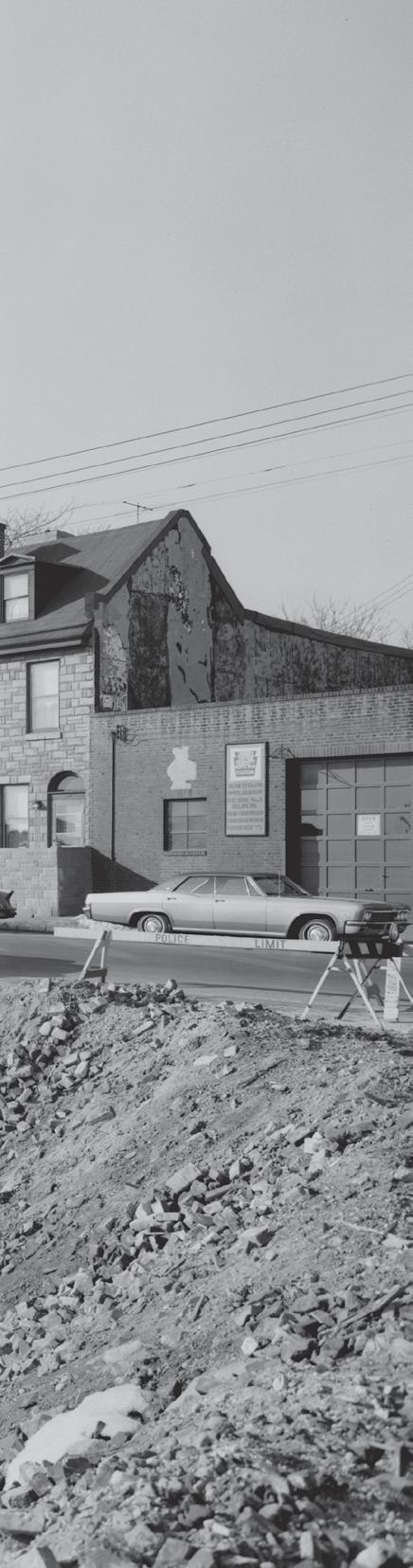
Street south to Fitzwater Street. (1966)
Photo courtesy of the Library of Congress Prints & Photographs Division, HABS PA, 51-PHILA, 432-2
Founded by the Swedes in 1664, Queen Village is Philadelphia’s oldest neighborhood. The Leni Lenape Native Americans called it Weccacoe, which means “Pleasant Place.” William Penn later renamed the area “Southwark” after the waterfront neighborhood in southeast London. In the mid-60s the Philadelphia Redevelopment Authority divided Southwark into Queen Village, Pennsport, Whitman and Society Hill. Queen Village Neighbors Association was incorporated as a nonprofit organization in November 1969.
Before QVNA was formed, in the mid50s, former Mayors Richardson Dilworth and William Clark, along with City Planner Ed Bacon and the Redevelopment Authority, devised a plan using eminent domain and federal transportation funds to push families out of Southwark’s northern area to create Society Hill and build I-95 along the land adjacent to Front Street.
The congregation at Gloria Dei Old Swedes’ Church, along with other smaller local groups, supported changing the highway’s route from Front Street to Delaware Avenue. But the railroads, to protect their own interests, opposed that plan and lobbied strongly for building the highway along Front Street. It’s sad to say, but the rest is history.
I-95 took 300 historically certified homes in Queen Village alone and many more in Pennsport and Whitman. Families were devastated having lived for many years in these neighborhoods and seeing their homes being demolished right before their eyes.
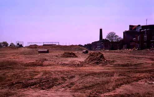
Infill for the interstate roadway is laid. Underpass structures near Washington Avenue can be seen in the distance (looking south toward Shot Tower located at Front and Carpenter streets).
Photo by Robert R. Wright, 1969

Elevated cement structure of I-95 takes shape above Front Street at Carpenter Street. Shot Tower seen in the background.
Photo by Robert R. Wright, 1969
The decision to build I-95 through the river wards may have been one of the worst planning decisions in Philadelphia’s history ripping the roots out from under hundreds of families and cutting their ties to the waterfront. I-95 now sits on some of the most valuable real estate in the city, which those in power years back were too shortsighted to envision. And, unfortunately, there were no civic groups with effective political clout to oppose it. The prevailing sentiment then was, “You can’t fight City Hall.”
But around 1970, the RDA set up a program that gave local civic groups the right and responsibility to plan the future of their neighborhoods through Project Area Committees. The South Central PAC included civic groups from river to river between Washington Avenue and Walnut Street. QVNA was recognized in this PAC as the civic group designated to plan for Queen Village and to communicate those plans to the RDA.
At that time QVNA consisted mostly of a small group of “newcomers” who wanted the neighborhood to be developed like another Society Hill. This did not sit well with the older, longtime residents who wanted to slow the gentrification process and tackle the impending problems that would be caused by the Crosstown Expressway. Tensions ran high for a while between the “old” and “new”, especially about neighborhood development, but the issues were resolved on both sides and energy was focused on stopping the Crosstown Expressway. A united QVNA, and a united South Central PAC, sent a strong message to the RDA and to our elected officials that we would indeed be responsible for planning our future.
The proposed Crosstown would have taken many more properties between Bainbridge and Lombard Streets from river to river. Property values in the South-Bainbridge Corridor plummeted. But, ironically, the proposed Crosstown helped stimulate the South Street Renaissance. A diverse group of artists and bohemian types found South Street affordable, moved in and began to transform the area into the “Hippest Street in Town.” With the growing number of galleries, restaurants, and shops, the streetscape slowly came back to life with new trees, lighting and sidewalk art, all spearheaded by this South Street renaissance community. All without taking any government money.
The older established Queen Village businesses and residents formed a bond with their new Renaissance neighbors to fight and defeat the construction of the Crosstown. This coalition used good old political clout as well as the media, demonstrations, fundraisers, and legal help to have the Crosstown removed from the City’s development plans. The resulting new attitude is still with us today as we advocate together for our neighborhood: “You can fight City Hall- and win.” ■
South Street's Real Estate Tax Value: 1972 vs. 2018
Queen Village Neighbors Association, united with other affected civic groups, fought and defeated the Crosstown Expressway. In 1972, City Hall removed the Crosstown from its development plans.
Ironically, the City realized a 4,861% increase in real estate taxes—revenue that would never have existed had the Crosstown killed South Street from river to river.
14
Queen Village Quarterly Crier // PAGE 15


