6 minute read
2021 Officers


Phone: 717.441.6057 PSLS Office--Lori Elliott — PSLS@psls.org Amy Hopkins—PSLSPres@psls.org Terry McMillen, Jr. —PresidentElect@psls.org Pete Brothers—VicePresident@psls.org Lawrence Leso—PSLSSec@psls.org Richard Shewman—Treasurer@psls.org Michael Given—NSPSDir@psls.org Brian Yorkiewicz—PastPresident@psls.org Shaheed Smith—Foundation@psls.org
PSLS Staff
Advertisement
Lori Elliott,
Executive Director Marcy Robey, Financial Coordinator Margaret Murphy,
Conference Coordinator Tiffany Carpenter,
Registrations Coordinator Jason Tobias ,
Membership and
Technology Coordinator Kathy Clough,
Receptionist
Amy Hopkins, President
Lawrence Leso, Secretary Terry McMillen, Jr., President-Elect Pete Brothers, Vice President
Richard Shewman, Treasurer Michael Given, NSPS Director Brian Yorkiewicz, Immed. Past President
PennDOT has maintained the Photogrammetry Asset Management System for nearly 20 years. This system is a repository for PennDOT flown Aerial Photography coverage and Survey Control Monuments across the state of Pennsylvania. PAMS was established for the Photogrammetry and Survey Section at PennDOT to track job progress and completion, have easy access to past project details, and maintain an up-todate catalogue of survey monuments statewide. PennDOT PAMS can be found at www.penndotpams.org and is accessible to anyone. The original development effort was carried out by geographIT, a Division of EAB Engineering Inc. under the direction of PennDOT’s Photogrammetry and Surveys Section.
As published in the article of The Pennsylvania Surveyor Summer 2020, “Educating the Public on the Importance of Monuments – Warren, PA” by Joseph McGraw, PLS, Northwest Chapter, survey monuments are extremely important to protecting the property of the citizens of the commonwealth. There indeed needs to be more education for government officials, construction contractors, and the general public on this topic. Surveyors know first-hand of this importance and the tragedy of losing these historically significant marks due to negligence or ignorance. In response to this on-going issue, PennDOT has expanded the use of its tools to surveyors across the state.
In the past, PennDOT PAMS has been used solely by geodetic surveyors of the Photogrammetry and Surveys Section in PennDOT to record high-order survey monuments and update their positions and condition over time. Having recognized the need to expand the use, there have been modernized releases and enhancements to the website to make this repository available to others. PennDOT’s Photogrammetry and Surveys section has currently entrusted geographIT with converting the site from an internal planning and tracking tool into a robust crowd sourcing system. Plans for this expansion were presented by the PAMS team at the 2019 PSLS Surveyor’s Conference at a seminar titled “PennDOT PAMS: Survey Control Database”. Over the past two years, these plans and ideas have developed into a functional reality.
When accessing PennDOT PAMS, any user can access survey monuments across the state from the Map View screen. Here users can utilize the search features, Identify or Circle Query, to select survey monuments from the Map View. A results grid will populate, users can view information about the mark, view datasheets, and now provide updates directly to PAMS Administrators for review. A guest user can use the button, Provide
PennDOT PAMS Desktop home page
Update, on a survey monument to provide additional recovery information, monument condition, and upload a photograph of the mark. A registered user will have full access to the database, in which they can provide positional information, datum updates, arrays of photos, descriptions and more. Registered user feedback will be reviewed by PAMS Administrators prior to acceptance into the database and final datasheet creation. New users can request a registered user login by emailing surveycontrol@pa.gov. With the assigned login, registered users can not only report information on existing marks, but they can also request that marks be added to the database to expand the quality data within the site.
Take the survey monuments from the Warren, PA article referenced above. A registered user; Surveyor, Government Official, Contractor, Geocacher, could request the existing Warren County survey monuments be added into the PennDOT PAMS database. The user could provide feedback on those marks and add photos. Once populated in the in the database, the monuments would be there for anyone to search and review. The information provided does not necessarily have to be survey grade. If a county were able to provide GIS quality locations to get the marks published, the datasheets will clearly reflect the survey monument’s quality and accuracies. The key is to upload these marks into a single repository available to all. Contractors could be made aware of this site at kick-off meetings or provided as part of construction contracts.
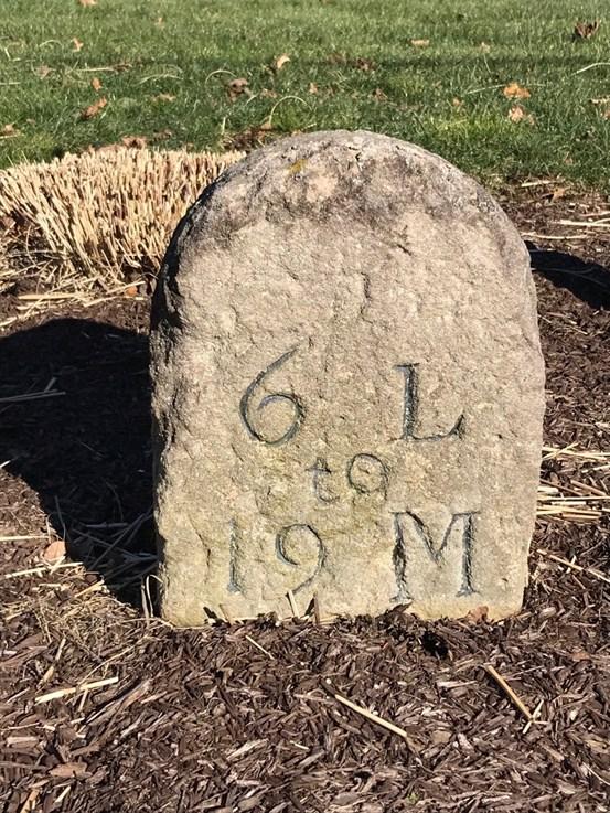
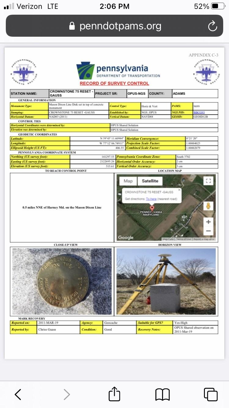
Community awareness campaigns could alert the public to the existence of these Survey Marks and their importance. The PAMS database is generally populated with high-order survey control established by National Geodetic Survey (NGS), PennDOT Survey Districts, PA Turnpike, county GIS monuments. The need to include other historically significant survey monuments has been made clear and that could be achieved with the assistance of private sector surveyors and the interested general public. Some examples of historically significant monuments currently in the database are Mason-Dixon Monuments (see “CROWNSTONE 75 RESET- GAUSS” record of control datasheet), Roadway Mileage Stones (see photos), and county line monuments. As Surveyors explore the usefulness of PAMS and its potential, they will also see tools to support the modernization of the National Spatial Reference System (NSRS). PAMS has NGS Coordinate Conversion and Transformation Tool (NCAT) functions
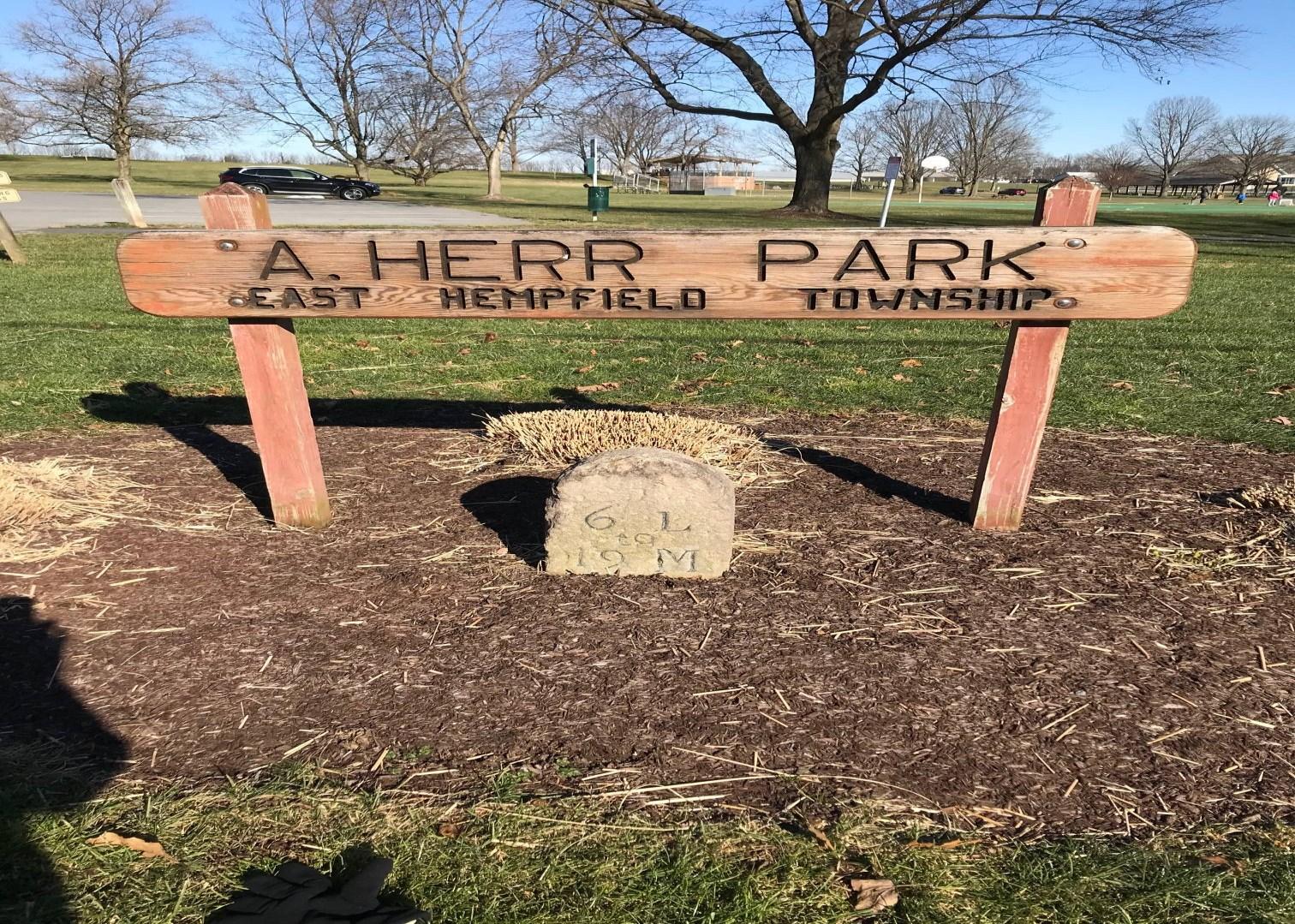
Roadway Mileage stone properly preserved in Lancaster County, East Hempfield Township, Amos Herr Park.
Roadway Mileage stone showing 6 miles to Lancaster and 19 miles to Mount Joy.
embedded into the results bar. This PAMS tool currently will take any mark in the database and transform its coordinates to the latest published horizontal and vertical datum using the official NGS parameters in NCAT. As NGS rolls out NATRF2022 and NAPGD2022 (new horizontal and vertical datums) and the proposed Pennsylvania State Plane Coordinate Zones change drastically from the existing PA North and PA South zones, the tool will project the coordinates to the new PA Single Statewide Zone and the new “Sub-zone” associated with the position of the survey monument. As surveyors plan future surveys, they can utilize PAMS to research existing monuments, review the newly transformed positions, and prepare properly for surveying into the future.
PennDOT PAMS is a multifunctional website that provides desktop and mobile access to a wealth of survey information. Users have access to many search and filter options to refine the criteria and achieve optimal search results. Modern up -to-date datasheets provide essential information regarding the position, description, and metadata for survey monuments. These sheets are linked to two NGS databases, the OPUS Shared Solutions and the IDB (Integrated Database, which is what generates NGS Datasheets), when available, to maintain the connection to the source of the data. Users are encouraged to utilize both PAMS Provide Update and NGS Survey Mark Recovery tools to ensure data is correct and current across both agencies. PAMS is a tool that ties the historic heritage of survey monuments to the present time usage of high-quality data to the future planning of surveys across the commonwealth and is available to all.
Link to PennDOT PAMS page: www.penndotpams.org Link to NCAT page: https:// geodesy.noaa.gov/NCAT/ Link to NGS Survey Mark Recovery page: https://geodesy.noaa.gov/surveys/mark-recovery/index.shtml
Pennsylvania Record of Survey Control Datasheet.