
2 minute read
You’ve seen these mountains from the ferry to Comox, but what do they look like from the OTHER SIDE? JASON ADDY takes us on a tour of Powell River’s mountains.

You could live in Powell River your whole life and never know about the amazing alpine terrain in the mountains just north of town.
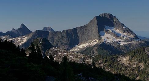
North face of Slide Mountain (2105 metres)
Advertisement
Even when you are on the ferry, and can see past the kilometers of rolling foothills to where mountain silhouettes rise above the forests, you still don’t get the full sense of what is waiting for you, just beyond.
Sixteen years ago, as my friend and I biked through Powell River, on our way back to Vancouver, he asked if I would ever consider moving here. It was my first time visiting, and as we cycled south to Saltery Bay, I flatly replied that I would never live in a town with so few mountains. I had been living in Vancouver for ten years at the time and spent all my spare time mountaineering in the areas north and east of the city.
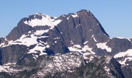
North face of Mount Baldy (2005 metres)
Fast forward five years, and I was looking for a job in Powell River to help make the mortgage payments on a house that I had just bought in Stillwater. When we’d started to look for somewhere to buy land, my wife smartly bought me the “Powell River Recreation Map,” with all the unseen mountains on it. I already owned the Climbing and Hiking in Southwestern BC guidebook, which featured a few Powell River mountains, and the two guides together were just enough for me to agree to try out Powell River – for five years.
In 2009, there were only five mountains in Powell River that I was interested in climbing. That’s it. My expectations were set low based on the small amount written about the local peaks. But, it wasn’t long before I realized how incredible the mountains north of town are. The lack of press for these peaks is of course a result of very few people living near them, and fewer still putting in the effort to explore them. It’s also because, for the most part, they remain invisible to anyone in town.

STRONGMAN: Chad Lavoie scales Mount Baldy at 2005 metres.
Photo by Jason Addy
Today, ten years into our five-year experiment of “trying out Powell River,” I am hooked. I have spent numerous weekends following abandoned logging roads to clear cuts, hiking through steep forests, and scrambling high into the alpine to stand on top of one of the many local peaks.

North side of the Rainbow Range (1839 metres)
I have climbed just 27 of these peaks, but each one has many facets. For instance, I have climbed Beartooth Mountain by three different routes over seven trips, in all kinds of conditions. In fact, I have spent close to two weeks of my life climbing, or failing to climb, Beartooth. And there are so many more peaks to get to.
Now I am writing a guidebook to these mountains. We are overdue for some updated and deeper information about the country north of Powell River. It will cover the region from town northward – everything between Jervis Inlet and Toba Inlet – and include close to 150 peaks, ranging from minor bumps on alpine ridges to mountains with sheer 1000m north-facing walls. I plan to have it available in the spring of 2021.

Jerry Philips on Beartooth Mountain (1903 metres)
FOLLOW JASON
If you would like to see more photos, see @powell_river_alpine on Instagram.
