SPRING 2026
ADVENTURES IN THE PACIFIC NORTHWEST
FREE
TULIP AND DAFFODIL HIKES OREGON COAST SPRING BREAK NOCA’S SHRINKING SUMMITS
YEAGER’s has the GEAR!
serving Whatcom County for Over 50 Years!
Adventure Awaits! Footwear • Apparel • Hunting • Fishing • Camping Ski Shop • Watersports • Kitchen • Toyland • And More!
3101 Northwest Ave, Bellingham, WA (360) 733-1080 yeagerssportinggoods.com
Celebrate
Sun-Soaked Summer Fun
We’re BIG on family-fun! Experience the ultimate summer adventure in Blaine by the Sea, where family-fun events and vibrant coastal vibes come together. Stroll through picturesque waterside
in Blaine by the Sea!
BLAINE WELCOME CENTER
parks or pedal along scenic biking trails that wind along the Salish Sea. Explore cozy boutiques, art galleries, a maritime museum, and ride the historic Plover Passenger Ferry. Indulge in mouthwatering farm-to-table cuisine that celebrates the season’s freshest flavors. This coastal haven by the Salish Sea offers peaceful moments that rejuvenate the soul.
546 Peace Portal Dr. I Blaine, WA I 360-332-4544
SECONDS OFF I-5, 276 AT THE US/CANADA BORDER
BLAINE W A S H I N G T O N
W W W. B L A I N E B Y T H E S E A . C O M
/BLAINEBYTHESEA
Whether you want to play or stay, join the fun in BIRCH BAY! THANK YOU for joining
us for the Largest Polar Bear Plunge Birch Bay has ever seen!
SAVE THE DATE FOR OUR SUMMER EVENTS Kids Kite Festival June 20 & 21
Sand Sculpture Competition August 1
Birch Bay Chamber of Commerce & Visitor Information Center
Birch Bay Chamber of Commerce & Visitor Information Center
Rollback Weekend Car Show August 2
National Night Out August 4
Birch Bay Derby Day August 29
For More Info Visit: www.birchbaychamber.com These events are made possible in part by a tourism promotion grant from Whatcom County.
SPRING 2026 | MOUNT BAKER EXPERIENCE
3
PUBLISHER’S NOTE by Kari Mar
S
pring arrives in the North Cascades like a quiet miracle that suddenly refuses to stay quiet. One day we’re wrapped in fog, stepping around puddles and wondering if the gray will ever lift—and the next, the valley erupts into daffodils and tulips, bold and unapologetic. Every Northwesterner knows the cue: out come the vests, the hiking boots, the plans we’ve been saving all winter. We rush outside, not just to see the change, but to feel it. It’s my honor to introduce myself as the new publisher of Mount Baker Experience. This landscape has shaped me in ways both subtle and profound. My parents were mountaineers, and some of my earliest memories are of early mornings filled with the smell of strong coffee, hotcakes and sausage before they set off to summit Mount Baker — twice, for good measure — along with so many peaks in Washington’s snow-capped treasury. Spring always feels like a possibility here. It may still be dark at supper time now, but we know what’s coming: those long, golden evenings stretching toward bedtime, inviting us to linger just a little longer. I’m grateful to take the helm of this publication and to share in telling the stories of this place. I hope you enjoy this issue as much as I do.
x
29
RIDING THE BAMBOO CURTAIN
Follow Dale Nottingham’s cycling journey through Vietnam
14
18
32
DAFFODIL FEST TWEED RIDE DAFFODIL & TULIP HIKES
NATUREBRIDGE
Put your wool coat on and hop on your penny-farthing
A peak inside Olympic National Park’s outdoor school
Discover Skagit County’s flower-friendly spring jaunts
08 NEWS Spring news and happenings from around the PNW
AND SLEEPS 42 EATS Grub and chill spots in the shadow of Mt. Baker
AND DAFFODIL ETIQUETTE 20 TULIP How to treat the Spring trails with respect
TO SEA 43 SKI Whatcom County’s favorite relay race back again
21 GALLERY Spring shots from Mt. Baker, B.C. and beyond
44 EVENTS Races, runs, rides and happenings
LOOP 36 TUCSON Cycling through the high desert
38
34
SPRING BREAK ON THE OREGON COAST Tony Moceri shares his family trip to the Oregon Coast
SHRINKING SUMMITS OF THE NORTH CASCADES Cameron Fenton examines our fast-changing peaks
Vancouver’s Best Kept Secret is Just Across the Line
J VANCOUVER 99
17
While the world gathers in Vancouver for the 2026 global tournaments, a hidden treasure awaits just minutes away. Discover Point Roberts, a unique American exclave on the Tsawwassen Peninsula, perfectly positioned off the Highway 99 corridor. This quiet corner of the Pacific Northwest always welcomes visitors with its blend of relaxed charm and natural beauty. Here, you can escape the crowds and find your moment of peace. Stroll through waterfront parks, hike pristine trails, or enjoy a round of golf on a championship course. BAY
ARY Retreat to the tranquility N D of Point Roberts. It’s the perfect balance of global U B O solitude. Just remember to bring your passport! energy and serene
R
TSAW WASSEN
A
IT OF
GE
OR
IA
SOUTH TO Make Point Roberts an essential Bpart E L L I of N G your H A M 2026 travel experience and & S E AT T discover an unforgettable destination. L E
M
GIA
POINT ROBERTS, WA
Our community thrives on connection and celebration, hosting events that bring together locals and visitors for unforgettable experiences. You won’t wantWHITE to missROCK the Fourth of July parade and the summer-long celebrations for our nation’s 250th birthday. And mark your calendar BLAINE for July 11, the 3rd Annual Point Roberts Strings & Things International Music Festival—a Y one-day celebration of string-driven artistry set BA against the Ostunning backdrop of the Salish Sea. Purchase tickets at O M stringsandthingsmusicfestival.com H SE
ST
BC T F E S AW RR W Y AS TE S RM EN IN A
L
Events can be big in our small seaside community.
POINT ROBERTS CHAMBER OF COMMERCE & VISITOR’S BUREAU
BIRCH BAY www.explorepointroberts.com
PHOTO: S T E PHE N F OW L E R
Explore the Tiny American Gem on the Canadian Salish Sea!
MOUNT BAKER EXPERIENCE Since 1986
CONTRIBUTORS
Special publication of Daffodil Press LLC PUBLISHER Kari Mar MANAGING EDITOR Kie Relyea
ERINDEINZER
EDITOR Nolan Baker
Erin Deinzer is a freelance writer residing in the Pacific Northwest. Specializing in business and leisure travel, she also recently published her first illustrated book for children titled Dracula’s Vampire Kitty.
COPY EDITOR Grace McCarthy GRAPHIC DESIGN Doug De Visser ADVERTISING SALES Gary Lee • Molly Ernst CONTRIBUTORS IN THIS ISSUE: Nancy K. Crowell, Chuck Kinzer, Bill Reynolds, Latrelle Scherffius, Damian Vines EMAIL: info@daffodilpress.net WEB: www.mountbakerexperience.com FACEBOOK: facebook.com/mtbakerexperience TWITTER: twitter.com/mb_experience INSTAGRAM: instagram.com/mtbakerexp If you can see Mt. Baker, you’re part of the experience. Mount Baker Experience is an outdoor recreation guide for and about the Mt. Baker region, distributed from Seattle to Vancouver, B.C. and published by Daffodil Press, LLC. Locally owned, the company also publishes The Northern Light, All Point Bulletin, Pacific Coast Weddings, Waterside, La Conner Community News and area maps. Vol. XLI, No. 2. Printed in Canada. ©2026 DAFFODIL PRESS 229 Marine Drive, Blaine, WA 98230 TEL: (360) 332-1777 NEXT ISSUE Summer 2026 Ads due: May 1
SPRING 2026
FREE
TULIP AND DAFFODIL HIKES OREGON COAST SPRING BREAK NOCA’S SHRINKING SUMMITS
6
CAMERONFENTON Cameron Fenton lives on the Canadian side of the North Cascades near Chilliwack, BC where he works as a writer and a guide.
JASONHUMMEL Jason is an outdoor photographer from Washington who has documented numerous first descents in the North Cascades. Alpinestateofmind.com
JASMINELONG Jasmine is a Bellingham-born creative with Olympic Peninsula roots. Owner of Mildcat, a modern art, photography and design collective. A lover of Mt. Baker and avid snow sport enthusiast. Find her online @ mildcatcreative and mildcat.org
ERICMICKELSON Eric is an outdoor photographer and restoration ecologist who is always willing to drop everything for a good adventure outside. He lives in Bellingham with his wife and daughter. ericmickelson.com
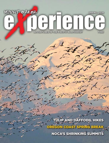
ON THE COVER Geese fly above the fields of Skagit County. Photo by Nancy K. Crowell
ADVENTURES IN THE PACIFIC NORTHWEST
MBE Spring 2026
MOUNT BAKER EXPERIENCE | SPRING 2026
TONYMOCERI Tony Moceri is a PNW native, author of A Wandering Mind, and co-host of the Drip Trickle Flow Flood podcast. He loves to get out and explore the world with his family; those adventures often serve as the inspiration for his writing and photography. Tony shares his journey on Instagram @tonymoceri and through his website www.tonymoceri.com
MIKENOLAN Mike Nolan is a freelance writer who lives in Port Angeles. His book “Hardhat Days” on his time in the Seattle shipyards is available through Washington State University Press.
DALENOTTINGHAM Dale is a serial wanderer with an entertaining but unemployable resumé. Dale spent most of his life working in publishing and media. Most recently he was the Managing Director of Forbes Vietnam. Dale is currently embroiled in the never-ending process of setting up his own company, Afflatus Media.
EVANSKOCZENSKI Evan Skoczenski is a lifestyle and landscape photographer born in Bellingham. He spends almost all his time chasing light and the next adventure.
ROSSWALLETTE Ross Wallette had an adventurous spirit and faith in God that guided the way he lived and loved others. He found joy in the beauty of the outdoors and his spirit and love will live on in the hearts of those who knew him.
COLINWISEMAN Colin Wiseman is an outdoor lifestyle and action sports photographer, writer, and producer who has lived in Bellingham since 2007. He also serves as the content and brand director for Funny Feeling LLC. Follow him on Instagram @ colin_wise_man and on the web at colinwisemancreative.com
JOSHWOODWARD Josh Woodward is a professional action sports photographer and videographer based in Bellingham. An athlete himself, Josh loves to participate as much in his subject’s sports as he does shooting them. MountBakerExperience.com
REGISTER NOW
September 20, 2026 FULL • HALF • 10K • 5K • RELAY
Use Code
MBE15
to save 15% on any race entry!
bellinghambaymarathon.org #RuntheBa
y
@bhambaymarathon SPRING 2026 | MOUNT BAKER EXPERIENCE
7
Newsroom
Notes big and small from around the region
Photo by Chuck Kinzer
Birch Bay Polar Bear Plunge Misses Mark for Guinness World Record Record attempt draws thousands, loses on technicalities. Despite a valiant effort that drew thousands of frigid participants — and even more cozy onlookers — Birch Bay’s attempt to break the Guinness World Record for largest polar bear dip was unsuccessful, according to the Birch Bay Chamber of Commerce. Guinness informed the chamber that two technicalities kept the record from being officially broken: non-participants in the plunge zone and some participants not being fully submerged for the entire duration of the dip, the chamber announced on Jan. 14. In order to break the Guinness World Record for largest polar bear dip, Guinness laid out specific requirements for both participants and onlookers. Those plunging into Birch Bay had to go waist deep, and remain waist deep, for at least one minute simultaneously. Those
8
MOUNT BAKER EXPERIENCE | SPRING 2026
watching were instructed to stay out of the water and nearby beach to avoid miscounts. The number to beat was 3,134 participants after the record was set in Norway on Dec. 13, 2025. While it is likely that there were enough participants to break the record, Guinness could not verify the exact number due to non-participants being in the designated plunge zone at the beginning of the attempt, according to the chamber. The chamber attempted to provide additional documentation to Guinness to help verify the attempt in the two weeks following the frigid plunge, but it was unsuccessful, according to social media posts. The chamber said it was still happy to provide the Birch Bay community with a jolt of energy amid the winter doldrums. “Despite falling short of the official record, the event achieved its original and most important goal: bringing the Birch Bay community together in celebration while welcoming thousands of new visitors to the bay during the traditionally quiet off-season,” the chamber wrote.
MountBakerExperience.com
Long-Stalled Bay to Baker Trail Gains Ground Fresh investment and organizational momentum signal a turning point for Whatcom County’s 74-mile corridor. Ask most Whatcom County outdoor enthusiasts about the Bay to Baker Trail and you’ll get an enthusiastic reaction — followed by a pause. The trail’s name carries real cachet in the local hiking and cycling community, but the on-the-ground reality has long fallen short of the vision. Of the proposed 74-mile route linking Bellingham Bay to the slopes of Mt. Baker Ski Area, only scattered segments near Bellingham and in the Maple Falls-to-Glacier corridor are actually rideable or walkable today. A slate of recent moves by county government and trail advocates suggests that gap may finally begin to close. Whatcom County Parks secured a $425,000 state grant through the Sandy Williams Connecting Communities Program late last year, and is targeting the segment between Kendall and Horseshoe Bend east of Glacier — one of the most critical missing links in the eastern corridor. The county intends to use the funds to open a formal planning process, bringing government agencies, tribal representatives, local businesses and community members to the table before any dirt moves. Parks Director Bennett Knox has been straightforward about where the trail stands. The name Bay to Baker has outpaced the infrastructure, he has acknowledged, noting that many locals assume the route is more complete than it is. His department is working to change that, including through a new hire. Karin Beringer, a former Silver Lake Park ranger, has joined county staff as a dedicated multi-modal trail planner with a focus on east county connections. Meanwhile, the trail’s Bellingham-side western anchor received a boost when the historic Little Squalicum Pier — a century-old structure originally built to haul cement by rail — was reopened for public use last spring, giving walkers a dra-
matic saltwater starting point with sweeping views across Bellingham Bay. On the advocacy front, Recreation Northwest convened the first-ever Whatcom Regional Trails Summit last December, helping build the coalition of voices pushing for both Bay to Baker and the newly rebranded Salish Coast Trail. None of this adds up to a completed trail — county officials and advocates are clear that full buildout remains a multi-decade endeavor. But for the hikers and mountain bikers who have been waiting for a continuous route from tidewater to timberline, the pieces are at least moving in the right direction. For public input opportunities, visit whatcomcounty.us/3553/Bayto-Baker-Trail. Continued on page 10
Brighter days and brighter flavors are around the corner. Enjoy refreshing beers and pizza in the sunshine this Spring in our beer garden.
Bellingham’s Favorite Italian Restaurant Since 1977
Open Thu - Mon • 4pm-9pm Dine in • Take Out • Online Ordering 1319 North State St., Bellingham 360.714.0188 dannascafeitaliano.com
Tap List, Menu, & Events Online:
www.larrabeelagerco.com
Visit Us: 4151 Guide Meridian Rd #100 Bellingham 98226
SPRING 2026 | MOUNT BAKER EXPERIENCE
9
Newsroom
Notes big and small from around the region
Continued from page 9 cific Northwest, flanking the Salish Sea along a corridor shaped for millennia by the Lummi Nation and Nooksack Tribe. A completed trail would connect communities, beaches, estuaries and public parks from Blaine and Birch Bay in the north down through Bellingham and Chuckanut to the Skagit County line. Like Bay to Baker, the Salish Coast Trail faces significant challenges — a patchwork of private land ownership, jurisdictional complexity and the need for broad coalition-building across tribal governments, county agencies and local stakeholders. No construction timeline has been announced. Recreation Northwest founder Todd Elsworth has described the organization’s role as filling a gap in regional trail advocacy — giving communities a unified voice to partner with local jurisdictions and push trail projects forward. For hikers and cyclists who have long wanted to explore Whatcom County’s coast on foot or by bike without dodging traffic, the Salish Coast Trail represents a compelling long-term vision. Whether it graduates from concept to corridor will depend on the same ingredients that define every trail project in the region: funding, patience and political will. Learn more at recreationnorthwest.com/projects/salish-coast-trail.
North Cascades Park Races to Rebuild After Record Stehekin Flood Emergency road reconstruction underway as park weighs race against spring runoff. The National Park Service (NPS) announced earlier this month it would move forward with emergency reconstruction of a washed-out road deep in the North Cascades, part of a broader effort to restore access and essential services to the remote Stehekin Valley following one of the most destructive floods in the region’s recorded history, according to a March 5 press release. In early December 2025, the Stehekin River surged to its second-largest flood level on record, triggering sweeping geomorphic change as the river shifted back into its historic floodplain. The event reshaped the lower valley and overwhelmed infrastructure that had stood for decades. The flood destroyed approximately 1,000 linear feet of Company Creek Road along with a 400-foot levee, cutting off safe vehicle access to properties beyond the damaged area. NPS is now moving to construct between 800 and 1,000 linear feet of elevated temporary road across federal lands to partially restore that access. Because the river’s Courtesy Recreation Northwest shift pushed the new road alignment onto private land in some secWhatcom County Eyes a Second Ambitious Trail tions, NPS is coordinating with Chelan County and local homeowners to The newly rebranded Salish Coast Trail would run the entire length of the integrate the private land component with the federal project, according to the NPS release. county’s shoreline, from the Canadian border to Skagit County. Officials are pushing to finish construction before spring runoff arrives, While the Bay to Baker Trail has long dominated the conversation around though the timeline carries uncertainty. Low snowpack, unseasonably warm Whatcom County trail development, a second corridor is quietly gaining temperatures or early runoff could all affect the project schedule, and access momentum — and a new name. The Coast Millennium Trail, a long-conceptualized route running the en- in and around the construction zone will be disrupted during the work. Road reconstruction is only part of the recovery picture. Repair work along tire length of Whatcom County’s coastline from Canada to Skagit County, is Stehekin Valley Road is already underway, trail crews are set to begin work being rebranded as the Salish Coast Trail. More than a branding update, the name change reflects a renewed push by on the Lakeshore Trail this spring, and the wastewater treatment plant at Stelocal trail advocates to build institutional support behind a project that has hekin Landing — buried under mud and debris during the flood — remains out of service. The facility serves a handful of park and private residences, existed mostly as a concept. Recreation Northwest, the Bellingham-based trail advocacy nonprofit the marina and the Stehekin Lodge. Park officials warn that full recovery will take time. The scale of the damthat also spearheads Bay to Baker efforts, hosted its first Whatcom Regional Trails Summit in December 2025, where the Salish Coast Trail was a central age, they say, means the work will proceed in phases well into the coming seasons — a tough break for one of the most beloved and isolated corners of topic alongside its east-west counterpart trail. The trail’s appeal is straightforward: Whatcom County’s coastline is among the North Cascades. For live travel and trail updates, visit nps.gov/noca. the most ecologically and culturally rich stretches of shoreline in the Pa-
10
MOUNT BAKER EXPERIENCE | SPRING 2026
MountBakerExperience.com
Lace Up: Anacortes Walk Fest Returns May 1-4 Four days of guided walks, local stories and fresh island air — no race bib required. Not every outdoor event needs a finish line. The inaugural Anacortes Walk Fest arrives May 1-4, offering something refreshingly low-key for the Pacific Northwest adventure crowd: a long weekend of small-group guided walks across Fidalgo Island, led entirely by local volunteers who actually know where the good stuff is. The festival features more than 25 walks spanning all levels of length, ease and interest — meaning whether you’re a serious trail hound or the kind of person who considers a stroll to the coffee shop a workout, there’s likely something on the schedule for you. Options range from easy waterfront strolls to more challenging forest trails, with routes covering Anacortes’ landscapes, rich history and local culture. A few highlights from the walk menu: a downtown public art tour through the Anacortes Creative District, a 6-mile flat ramble along the Tommy Thompson Trail with sweeping water views, an old-growth forest walk featuring “big trees, little lichens and fungi,” and a history walk tracing the women of Anacortes from past to present. Trail outings are capped at 12 walkers, with downtown walks limited to 16 so this isn’t a crowd situation. It’s the kind of event where you might actually learn your fellow walkers’ names. Registration is open now at anacorteswalkfest.com. Spots are already filling up!
Photo by Louise Mugar
Boundary Bay Brewery to Open Smaller Downtown Bellingham Location on State Street Bellingham’s beloved brewery gets new, ‘nano’ digs. When Boundary Bay Brewery announced the closure of its iconic Railroad Avenue brewpub last year, many Bellingham regulars feared the end of a 30year institution. Owners Ed Bennett and Janet Lightner cited the building owner’s decision to sell as the catalyst — but it turns out the story doesn’t end there. The brewery announced in February that it is opening a new, smaller space in downtown Bellingham on State Street. The concept represents a deliberate departure from the sprawling Railroad Avenue brewpub that made Boundary Bay a regional landmark. Dubbed “Boundary on State,” the new spot will feature a nanobrewery alongside a rotating, curated food menu, wine and signature cocktails, in addition to the core Boundary Bay beers that loyal customers already know. The brewery describes the space as one “built for conversation, connection and community.” The announcement was accompanied by a photo of next-generation family members holding the old Boundary Bay taproom sign outside the new State Street location — a visual passing of the torch that signals the brewery’s future may be in younger hands. Bennett and Lightner built Boundary Bay into what Bennett called the largest brewpub in the United States, growing to more than 100 employees and earning a national reputation as a pioneer of the Pacific Northwest craft beer scene. The new State Street location trades that scale for something more intimate — a neighborhood gathering place that tips its hat to the original while charting a new course. No opening date has been announced. Updates are expected at bbaybrewery.com.
Built in Bellingham for four-season life in the Cascades. Kimbo aluminum truck campers — strength outside, sanctuary within.
scan to step inside kimboliving.com/baker SPRING 2026 | MOUNT BAKER EXPERIENCE
11
S
North Cascades Institute Spring Events
pring arrives slowly in the North Cascades — snowfields linger on the high peaks while the valleys below fill with birdsong, wildflowers and the first green push of new growth. It’s a season that rewards attention, and the North Cascades Institute has built a roster of programs designed to help people pay it. From a floating marine science lab on Bellingham Bay to a campsite in the Methow Valley at dawn, from kelpstrewn tidepools near Port Townsend to a watercolor easel on the shores of Diablo Lake, this spring’s offerings span the full range of the region’s ecosystems — and the full range of ways a person might want to engage with them. Read on for descriptions of some of NCI’s upcoming spring events.
Salish Seaweed Garden: A Day of Sea Veggie Foraging, Feasting and Ecology Deception Pass State Park April 18, 19, 8:45 a.m. – 4 p.m. Cost: $215 Some of the most nutritious vegetables on Earth grow right in the Salish Sea — and on April 18, the North Cascades Institute invites you to harvest them yourself. Led by Jennifer Hahn, natu-
ralist, seaweed scientist and author of “Pacific Feast: A Cook’s Guide to West Coast Foraging and Cuisine,” this oneday workshop near Port Townsend is equal parts field science and culinary adventure. Timed to coincide with a minus spring tide and the one-month window for public recreational seaweed harvesting at a state park, participants will wade the shoreline collecting fresh sea vegetables before retreating to a covered picnic shelter. There, the real fun begins: the group prepares five dishes together, including chocolate ocean pudding and fresh kelp “fettuccine” — mineral-rich, gluten-free and surprisingly delicious. Along the way, Hahn covers kelp ecology, sustainable harvesting, and the growing Pacific Northwest movement around kelp restoration.
Salish Sea Marine Science on the Snow Goose Bellingham Bay April 25, 9 a.m. – 3 p.m. Cost: $225 Aboard the Snow Goose — a spacious 65-foot research vessel — the North Cascades Institute offers a hands-on, one-day field class exploring the living science of the Salish Sea. Taking place
February 28 & March 1, 2026
Vancouver Convention Ctr.
Hundreds of exhibits showcasing the best outdoor gear & adventure travel experiences!
www.OutdoorAdventureShow.ca
April 25 on Bellingham Bay, the experience is guided by Capt. Dan Linden and designed for curious adults ready to do real marine research. As the vessel travels to several study locations, participants work in small groups using scientific tools common in marine research settings. Rotating stations cover plankton, water quality, dissolved oxygen and watersheds — building a picture of how the interplay between fresh and salt water shapes the broader health of the Salish Sea. It’s an approachable outing for non-scientists and seasoned naturalists alike, with an activity level suited to most adults.
Springtime Watercolor in the North Cascades NCI Environmental Learning Center May 1 – May 2 Cost: $300-$580 Set against the lingering snowfields of Pyramid Peak and Colonial Peak, this two-day watercolor seminar invites artists of all levels to capture the bright, fleeting colors of spring in the North Cascades. The event runs May 1-2 at the North Cascades Environmental Learning Center on the shores of Diablo Lake. Instructor Molly Hashimoto — a longtime institute instructor and author of “Wildflowers of the West: An Artist’s Guide” — leads participants through techniques for capturing springtime light, color and form using watercolor and other water-based media. Weather permitting, much of the class takes place outdoors in the fresh air, with a planned field trip to the Diablo Lake Overlook. Lodging and three meals at the learning center are included. North Cascades Spring Naturalist Seminar NCI Environmental Learning Center May 1 – 3 Cost: $345-$625 Spring in the North Cascades moves fast; trillium shift color, mushrooms fruit overnight, and salmonberries rip-
en before you’ve noticed the season has turned. This three-day seminar, running May 1-3 at the North Cascades Environmental Learning Center, is designed for people who want to keep up. Naturalist and educator Chris Byrd leads participants out on the trails each day, building the kind of observational fluency that lets you read a forest the way others read a room. The focus is Pacific Northwest native plants — their identification, their ecological roles and their relationships with fungi, animals and one another — but the deeper aim is sharpening the instincts that make any time outdoors richer. It’s a good fit for aspiring naturalists, educators and serious outdoor enthusiasts ready to move beyond casual curiosity. Lodging and meals at the learning center are included; scholarships and discounts are available.
Spring Birding in the Methow Valley Pearrygin Lake State Park May 29 – 31 Cost: $375 By late May, the Methow Valley is loud. Migrant birds have settled onto nests, the morning chorus is in full swing, and the sagebrush and cottonwood corridors are alive with birds that spent the winter as far away as the Andes or the rainforests of Central America. It’s one of the best birding windows of the year — and a good reason to get up early. This three-day camping-based seminar, running May 29-31 out of Pearrygin Lake State Park, is led by Libby Mills, who has taught natural history in the North Cascades for more than 35 years. Days start at first light and move through a range of habitats — sagebrush steppe, ponderosa pine forest, riparian corridors, burn areas and pond edges — with an emphasis on learning to listen as much as look. Participants camp at the park and should plan to bring most of their own food; Friday’s potluck dinner is the one communal meal.
x
LOOKING FOR A SKI CABIN OR A PLACE IN THE CITY?
wn r o t! u ea yo to Retr ! e ow ap ain Esc ount ble N M vaila A
Call Damian, your Whatcom County Real Estate expert and Volunteer Ski Patroller. Helping people on and off the mountain for over 20 years.
Damian Pro MyProTeam.com • 360-303-5072 12
MOUNT BAKER EXPERIENCE | SPRING 2026
MountBakerExperience.com
EVIL-BIKES.COM Bellingham, WA
SPRING 2026 | MOUNT BAKER EXPERIENCE
13
Local Dandy Daffodil Tweed Ride is stylish throwback to simpler times Story by Bill Reynolds Photos by Damian Vines Photography
When the snow melts... When the snow melts...
...follow it to the sea! ...follow it to the sea!
Experienced or new boating, we we cancan help you Experienced orto new to boating, help youdiscover discover the joysthe of joys cruising the Salish Sea!Sea! Beginner totoadvanced of cruising the Salish Beginner advanced Sailboat and powerboat bareboat charters. courses.courses. Sailboat and powerboat bareboat charters. sanjuansailing.com · 360-671-4300 · Bellingham sanjuansailing.com · 360-671-4300 · Bellingham
14
MOUNT BAKER EXPERIENCE | SPRING 2026
B
eing told to stay in your lane isn’t a dis when it comes to the annual Dandy Daffodil Tweed Ride in La Conner. In fact, it’s a badge of honor. “A tweed ride is a throwback to a slower, simpler time long before computers and cellphones consumed our lives — a time when families would don their Sunday best, pack a picnic basket, and take a leisurely bicycle jaunt through the countryside,” explains Damian Vines, one of the popular event’s organizers. In the case of the March 21 tweed ride here, it will be a user-friendly trek from La Conner Swinomish Library to Christianson’s Nursery for lunch and then back to town. Choosing La Conner and its stunning nearby daffodil fields as the focal point for a tweed ride has been a winner on several levels, says Jonathon Royer, another of the local cycling venture’s coordinators. “La Conner itself is a picturesque city and a perfect jumping-off spot for this event,” Royer says. “It’s an unhurried event where the only thing you’ll need your smartphone for is taking pictures. “The key element for me is the social aspect and riding slowly, chatting and making new friends,” he adds. “The route is relatively flat through the farm fields of La Conner and the Skagit Valley. On a clear day you can get incredible views of Mount Baker in the distance. And the picnic at Christianson’s Nursery is always a highlight.” Another bonus is that the Dandy Daffodil Tweed Ride is a fundraiser for the La Conner Swinomish Library Foundation. Proceeds from the $25 ticket sales are donated to the foundation in support of the library. Ticket info is available at dandydaffodil.com. Typically, Tweed Ride participants arrive here from throughout Washington state, with about 85% being residents of Skagit or Whatcom counties. Some hail from British Columbia, Vines says. For the 2026 event, there are also registered entrants from ConnectiMountBakerExperience.com
cut and California. Those in the La Conner area on Tweed Ride Day will likely catch peeks of several bikes from bygone eras. “There are usually a handful of vintage bicycles, and it’s always exciting to be riding next to a Penny Farthing,” Royer says. Style, of course, rivals substance for tweed rides. “We really encourage people to dress in tweed or period garb,” Royer says. “It makes the ride very unique and if it rains, wool is water repellent.” Still, riders don’t necessarily have to bust their clothing budgets to join in. “It doesn’t have to be fancy,” Royer says. “I’ve found several tweed sport coats and pants while thrifting.” What if you don’t have tweed? Organizers offer other options. “Tweed is king as we like to say,” Vines says. “Wool is also very popular. Any vintage clothing from the past is highly encouraged — vests, bowties, bowler hats, knickers, scarves and gloves. It’s a sophisticated ride.” A laid-back and relaxing social ride with beautiful scenery, Vines promotes the Dandy Daffodil Tweed Ride in quite English terms, referring to it as “a jolly good time.” Royer estimates that about 100 cyclists will enter the 2026 La Conner ride, which was founded by Corey and the late Bonnie Stout. It is in its eighth year after being temporarily suspended during the COVID-19 pandemic. “They had started riding events in New Mexico that are still going strong to this day,” Royer says of the Stouts. “They moved to Camano Island and
thought that the Skagit Valley would be a great place to do additional events.” One of the beauties of La Conner’s tweed ride, Vines and Royer say, is its inclusivity. “Your riding ability doesn’t matter,” Royer notes. “This is not a race. It’s for
Bellingham, WA • Lynden, WA
BOOKS & GIFTS BOOKS • GIFTS • CARDS new & used
fun & unique
candy & toys
BOOTS BUILT TO LAST
Local guides,Event Find Author decor, toys, attire, Information cards, candy, and games & more! browse 24/7 at
villagebooks.com
OPEN DAILY 1200 11th St, Bellingham, WA l 430 Front St, Lynden, WA 360.671.2626 • open daily • 360.526.2133
430 Front St., Lynden, WA villagebooks.com Waples Mercantile Building
Open Daily
Organic Custom Tea Blends & Spice Blends • Bulk Teas/Blends • Bulk Spices/Blends • Bodycare • Tinctures • Essential Oils I5 & MERIDIAN | 133 TELEGRAPH RD, BELLINGHAM | 3607332500
Voted Best Mediation Services in Bellingham!
We Ship!
Wonderland Herbs, Tea & Spices
1305 Railroad Ave. Bellingham Local for 49 years! 360-733-0517 WonderlandHerbsTeasSpices.Wordpress.com
Divorce/Parenting • Eldercare • Marital • Land Use • Contracts • Employment
4073 Hannegan Rd, Bellingham | HollysMeatPies.com SPRING 2026 | MOUNT BAKER EXPERIENCE
15
Fresh Baked Goods Bellingham Coffee roasters Coffee & Espresso Behind Glacier Ski Shop • Open Everyday Glacier, WA
the human race, but it’s definitely not a race.” Plus the opportunity, if ever so briefly, to explore a cherished bygone era. “I just want people to come, take a break from technology, feel the wind in their face — and maybe some rain — and ride together as a community,” Royer says. The setting couldn’t be better. “We slowly meander through the valley among the daffodil fields,” Vines says, “in hopes of getting a glimpse of the yellow splendor.” Bill Reynolds is a general assignment reporter for La Conner Community News.
x
Happy Hour Monday thru Thursday 12:00 - 5:00pm All Day Friday Freshly-Brewed, Small-Batch Ales, Lagers & Barrel-Aged Sours
Vacation homes in Glacier, WA near Mt. Baker Come get away from it all with Serene Mountain Escapes, where we’ll help you make beautiful memories to last a lifetime. Choose from: ~ Pools & Hot Tubs
~ Mountain View Homes
~ Large & Luxury
~ Small & Cozy
~ 1 – 12 Guests
~ Pet Friendly
Enjoy Hand Tossed Pizzas, Grinders, Salads, Desserts, and Daily Food Specials Open Every Day Noon - 9:00pm 6186 Mt. Baker Highway (360) 599-BEER northforkbrewery.com
16
MOUNT BAKER EXPERIENCE | SPRING 2026
MountBakerExperience.com
Kandi Camacho Real Estate Broker Hablo Español
Your Neighborhood Real Estate Team
360-410-9114
Be Part of the Experience
MountBakerExperience.com
Mt Baker Visitors Center
Cammie Starkenburg, Kandi Camacho
ANNUAL & DAILY
Pacificpinesproperties.com
The Knotty Lodge - GLACIER, WA
Check out our Art Gallery Recreational Passes Available Here!
info@pacificpinesproperties.com
View Pictures & Book online at
Open Daily 10 a.m. - 4 p.m.
www.vrbo.com/563675 or call 360.303.2887
Maple Falls corner of Mt. Baker Hwy. and Silver Lake Rd.
360-599-1518 • www.mtbakerchamber.org
• Fresh organic produce & organic dairy items • Best beer & wine selection east of Bellingham MONTHLY GROCERY SPECIALS!
7466 Mt. Baker Hwy. 360-746-8734
GREEN STOP MT BAKER
MAPLE FALLS • WASHINGTON
@green_stop_mt_baker • 21+
WARNING: There may be health risks associated with consumption of this product. This product has intoxicating effects and may be habit forming. Smoking is hazardous to your health. Marijuana should not be used by women that are pregnant or breast feeding. Marijuana can impair concentration, coordination, and judgment. Do not operate a vehicle or machinery under the influence of this drug. Marijuana may not be legal in your area. Any marijuana products shown here are for Adults 21+ to consume within Washington State.
NEW
Organic Items Every Week!
MT BAKER SOUVENIRS
INCLUDING T-SHIRTS SWEATSHIRTS
• Gluten free products • Vitamins & Herbal Supplements • International foods • Bulk Foods • Hardware Section • NW Forest Passes/Sno-Park Passes • Great Pet Food/Treat Dept.
THE BEER CAVE
Over 200 kinds of COLD BEER to choose from!
Check out our merchandise from local artists Follow Us On
OPEN SUN. - THURS. 7AM-8PM & FRI. - SAT. 7AM-9PM At the crossroads of Mt. Baker Highway & Silver Lake Rd. 7802 Silver Lake Road in Maple Falls 360-599-9657 SPRING 2026 | MOUNT BAKER EXPERIENCE
17
BEST HIKES
for viewing the
tulipfields in Skagit County Photos by Nancy K. Crowell
E
very spring, the Skagit Valley transforms into a living canvas with bands of tulips blooming in brilliant stripes of crimson, gold, lavender, ivory and electric pink that stretch across the fertile farmland. While many visitors experience the tulips from roadside farm stands or festival routes, the most breathtaking views come from above. Climb a little higher and the valley reveals itself as a patchwork: geometric fields stitched together by winding rivers, framed by the San Juan Islands to the west and the snow-capped Mount Baker rising to the east. From these elevated trails, you can see not just the flowers, but the full working landscape — dairy barns, drainage canals, tractors moving between rows — that makes this short, spectacular bloom possible. Whether you want a gentle forest loop, a paved climb with a picnic at the top or a moderate summit with sweeping Salish Sea views, these hikes offer some of the best vantage points for seeing Skagit County’s tulip fields in full color.
Tulip views on an easy forest stroll La-Z-Boy and Rooty Loop For a short, gentle hike within Little Mountain Park, the La-ZBoy and Rooty Loop offers a peaceful woodland walk with occasional openings that hint at the colorful spectacle below. While much of the 1.4-mile loop winds through the forest, the higher elevations within the park still provide glimpses of the Skagit Valley farmland. It’s a good choice for visitors who want to combine wildflowers, birdsong and a relaxed forest setting with the broader agricultural views available from nearby viewpoints. Because the loop is short and relatively flat, it’s ideal during tulip season when parking and traffic can be busy elsewhere. Hike early or later in the day for quieter conditions, then head to one of the park’s viewpoints for the full panorama. Trailhead Location: Little Mountain Park, Mount Vernon Length: 1.4-mile loop Elevation Gain: Approximately 200 feet Difficulty: Easy Estimated Hiking Time: 30-60 minutes
The “You Name It - We Got It” Store
CASCADE SUPPLY
Camping Supplies Sporting Goods & Tackle Hardware Electrical Plumbing Lumber
OPEN Monday-Saturday: 8:30 AM TO 5 PM
45900 Main Street • Concrete (360) 853-8811
IT’SN G A OW K S
Paint Gifts
The Valley’s Best Seafood!
EBT Daily Lunch Specials with Local Seafood! Delicious freshly-prepared!
SHOP HERE FOR LOCAL GIFT ITEMS
Open Daily to Everyone!
360.336.9777 • skagitfoodcoop.com
18
MOUNT BAKER EXPERIENCE | SPRING 2026
Jams • Jellies • Salsas • Honey • Sauces • Dungeness Crab Fresh Fish • Clams • Mussels • Oysters for every taste! Shrimp • Scallops • Smoked Fish
360.707.2722 • 18042 Hwy 20 • Burlington • www.SkagitFish.com MountBakerExperience.com
A front-row seat to Skagit Valley’s rainbows of tulips Little Mountain Park Little Mountain is one of the most accessible ways to see the Skagit Valley’s tulip fields unfurl in rainbow ribbons below you. Rising just south of Mount Vernon, the park’s summit viewpoints overlook the broad agricultural flats where neat rectangles of farmland burst into bands of scarlet, fuchsia, buttery yellow and royal purple each spring. From the covered viewpoint at the top, you can trace the geometry of the valley floor and, on clear days, admire the San Juan Islands and Olympic Mountains. The north viewpoint frames Mount Baker dramatically above the farmland, creating that classic Skagit contrast of snow-capped peaks towering over fields of tulips in full bloom. Because you can drive or hike to the top on the paved road, Little Mountain is ideal for families, photographers or anyone who wants maximum color payoff with flexible effort. The network of intersecting trails means you can extend your outing or keep it short. Bring a picnic and linger — this is one of the best places to watch the afternoon light intensify the tulip fields’ saturated hues. Summit Road to Little Mountain Viewpoint Trailhead Location: Little Mountain Park, south of Mount Vernon Length: 3-mile round trip (via paved road) Elevation Gain: 934 feet Difficulty: Moderate (steady uphill climb on pavement) Estimated Hiking Time: 1.5-2.5 hours
Tulip fields meet the Salish Sea Oyster Dome and Samish Outlook If you want to see the tulip fields in their full regional context — farmland meeting tidewater — Oyster Dome delivers one of the most commanding views in northwest Washington. Perched high on Blanchard Mountain above Samish Bay, the rocky promontory reveals the Skagit River flats spreading wide to the south. In April, those fertile flats transform into luminous stripes of tulips that are visible even from this lofty vantage point. From the dome, you can sweep your gaze from the checkerboard farmland around Mount Vernon and La Conner to the shimmering waters of Samish Bay and the San Juan Islands beyond. Mount Baker often rises brilliantly behind the valley, creating a layered composition: snow peak, farmland, rainbow tulip bands and sea. It’s a moderate climb with a dramatic payoff — especially on clear spring days when the colors below appear almost painted onto the earth. Because the overlook is sheer rock, visitors should use caution near the edge, particularly with children and pets. For photographers and hikers seeking one of the most iconic Skagit Valley perspectives during tulip season, Oyster Dome is hard to beat. Trailhead Location: Samish Overlook, Blanchard Mountain (near Alger) Coordinates: 48.6096, -122.4264 Length: 5-mile round trip Elevation Gain: 1,050 feet Difficulty: Moderate Estimated Hiking Time: 2.5-4 hours Parking Pass: Discover Pass required
Experience the most amazing pizza in Skagit Valley! TAKE-OUT OR DINE IN
Tulip fields from the sky Mount Erie If you want a sweeping, almost aerial view of Skagit County’s farmland quilted in technicolor, Mount Erie delivers. Rising above Anacortes, this summit hike gives you a wide-open vantage point where the Skagit Valley spreads out below in geometric perfection. From the summit viewpoints (ignore the parking lot and head toward the antennae), you can trace the tidy lines of fields stretching toward Mount Baker and the Cascades, with the Swinomish Channel and islands shimmering to the west. It’s a reminder that the tulip fields are not isolated attractions, but part of a vast working landscape that makes the Skagit Valley bloom. Because Mount Erie rises steeply from near sea level, the payoff-to-effort ratio is excellent. Even on a partly cloudy day, the elevation helps you see the color contrast between the vivid tulip bands and the earthy browns and greens of surrounding farmland. During peak bloom in April, it’s one of the most dramatic panoramic views in the county. Trailhead Location: Anacortes Community Forest Lands (Heart Lake Road, Anacortes) Coordinates: 48.4690, -122.6294 Length: Approximately 4-5 miles round trip Difficulty: Moderate (steady elevation gain with multiple climbs) Estimated Hiking Time: 2.5 to 4 hours, depending on route and pace
x
Your local footwear experts.
Pizza • Homemade Soups • Subs & Grinders Pasta • Salads • Beer & Wine OPEN Tues. - Sat. 11 a.m. - 9 p.m.
360-853-7227 AnniesPizzaStation.net 44568 State Route 20 • Concrete, WA
821 METCALF STREET • SEDRO-WOOLLEY, WA 98284 360-855-0395 • OLIVERHAMMER.COM OPEN MON.-SAT. 9AM-5PM
Serving Skagit County Since 1921
420 E FAIRHAVEN AVE DOWNTOWN BURLINGTON 360-755-0570 OPEN MON-SAT 9-6 SPRING 2026 | MOUNT BAKER EXPERIENCE
19
Etiquette (or how to not be THAT tourist) Story and photos by Nancy K. Crowell La Conner Community News
C
haos and color! Spring may not be official, but between the traffic jams and technicolor flower fields, confluence of snow geese and beckoning blue skies, the Skagit Valley welcomed its first full load of traveling petal peepers by early March. And as the days start lengthening, the numbers of visitors will start building. We know — you’re pining for that towering cone at Snow Goose Produce, and your camera roll is begging for a bloom-tiful backdrop. The birds? Oh, they’re flocking fabulous. It’s basically feathered Coachella out there. Whether it’s your first visit or your 1,000th, here’s how to be a welcome guest — not a buzzkill in yoga pants.
Don’t be a flower thief Flowers in fields are not for picking. They are for picturing. Snap away. Hands off the merchandise. There is no such thing as a roadside parking fairy The middle of the road is not a parking space. Promise: the flowers will still be there after you locate a safe, sensible spot. If you’re
20
MOUNT BAKER EXPERIENCE | SPRING 2026
birdwatching, look for “Be Bird Wise” signs. Those areas are basically the avian-approved VIP section—binocs-bearing bird nerds welcome. Ignore this warning and get to know your local Sheriff.
ter in a dairy-based drama. Don’t cut. Make friends. Debate flavors. Embrace the churn. Also, insider’s tip, there are other places that sell ice cream if your patience factor is minus zero.
Birds are not your personal air show If your only zoom lens is attached to a cellphone, that does not make it open season to stroll toward flocks and make them fly. Geese and swans are bulking up for a marathon migration back to Siberia. Every unnecessary takeoff burns precious fuel. Imagine someone charging through your Thanksgiving dinner yelling, “Do it again!” Exactly. Don’t. Same goes for those little owls everyone loves leave 'em be and they will pose nicely for you.
One way means one way On First Street in La Conner, traffic flows south. Not north. Not “just for a second.” If you attempt vehicular salmon behavior, locals will absolutely notice, and probably tease you — especially once you finally park and stroll into La Conner Brewing Company like nothing happened.
Private property is not a suggestion It doesn’t mean “unless the lighting is really good.” It means stay out. Trespassing is never in season. Cone etiquette is real Yes, it’s time to stand in line at Snow Goose Produce. No, you are not the main charac-
Leash the unleashed Dogs do not get a hall pass to chase birds. Keep that pup tethered and everyone stays tail-wagging happy. Unleash the beast, unleash the consequences. Tip like you mean it If you’re here for the sights, support the sites. Grab lunch, buy a coffee, fill the tank, purchase local art, pay for parking. It keeps the valley blooming year after year. Come for the flowers. Stay for the feathers. Leave without being “that” person.
x
MountBakerExperience.com
GALLERY Page 21: From top: Ripping through the spring mud. Photo by Evan Skoczenski. Through the ferns en route to Glacier Peak. Photo by Jason Hummel.
SPRING 2026 | MOUNT BAKER EXPERIENCE
21
22
MOUNT BAKER EXPERIENCE | SPRING 2026
MountBakerExperience.com
GALLERY Page 22: From top: Photo by Eric Mickelson. Fishing with a friend. Photo by Jasmine Long. Page 23: From top: The lush greens of springtime. Photo by Evan Skoczenski. Light bursts through the winter gray onto the North Cascades. Photo by Jasmine Long.
SPRING 2026 | MOUNT BAKER EXPERIENCE
23
24
MOUNT BAKER EXPERIENCE | SPRING 2026
MountBakerExperience.com
GALLERY Page 24: Barefoot fishing in Olympic National Park. Photo by Nick Danielson Page 25: From top: Jake Taylor hits a jump on Chuckanut Mountain. Photo by Josh Woodward. Signs of spring in Skagit County. Photo by Nancy K. Crowell.
SPRING 2026 | MOUNT BAKER EXPERIENCE
25
Page 26: The friends you meet along the way through the North Cascades. Photos by Jasmine Long. Page 27: From top: Sunsets and surfing on the Olympic Coast. Photos by Jasmine Long.
26
MOUNT BAKER EXPERIENCE | SPRING 2026
MountBakerExperience.com
GALLERY
SPRING 2026 | MOUNT BAKER EXPERIENCE
27
Page 28: From left: Ripping a Skagit County trail. Photo by Colin Wiseman. Trekking up to Glacier Peak. Photo by Jason Hummel.
28
MOUNT BAKER EXPERIENCE | SPRING 2026
MountBakerExperience.com
In the wake of
Wipha The storm before the calm: a cycling tale By Dale Peter Nottingham
Originally published December 5, 2025 on Dale’s substack, Afflatus: khundale.substack.com/p/in-the-wake-of-wipha
I
am sitting on the cafe terrace. My ample buttocks lavishly overhang the extremities of the tiny concrete stool: outdoor furniture for the apocalypse. Facing me across the matching concrete table, sits my would-be next ex-boss. The amplitude of his derrière threatens to eclipse any empirical evidence his stool exists at all. I think of Bertrand Russell. It is not yet 9 o’clock in the morning but this is Saigon so I’m already perspiring like a Magaluf meth head. Our negotiation continues.
“You can have 20 days of holiday per year but you must take 10 of those at the end of June.” I protest at this estival imposition, citing a shaggy-dog devotion to “Christmas with the family” but to no effect. I reluctantly accept his proviso and immediately start thinking about the epic 10day cycling expedition that will fill this midsummer void. Having already completed many of Vietnam’s great cycling challenges, including Saigon to Hanoi, Hanoi to Saigon, The Ha Giang Loop, the Extreme Northeast, the even more Extreme Northwest and sundry other forays up, down and around this enchanted land, coming up with a suitable encore will not be easy. The search begins.
And then, one lazy afternoon, as I’m idly perusing the latest estimable offerings from vietnamcoracle.com – my go-to resource for cycling inspiration – I find my answer: the Trans-Northern Belt Road. I melt into the intoxicating description on my screen of the 582-mile route: “Traversing the breadth of Vietnam from east to west at its widest and most mountainous point, the Trans-Northern Belt Road (Đường Vành Đai Phía Bắc) is an historic route and the third longest road in the nation, measuring 937km. The road passes through 10 northern provinces and some of the most spectacular landscapes and complex terrain in the country.” In this moment it is decided. I book my flight north and immediately switch to drinking skimmed milk, as I will need to be in peak physical condition for this arduous undertaking. Such attention to detail, however, is no match for the whims and caprices of Mother Nature. And so it is that four days before my departure for Ha Long Bay – the starting point of my tour – Wipha, a typhoon-cum-tropical storm slams into Vietnam, precisely at Ha Long Bay, before rolling west, wreaking havoc and destruction along, as luck would have it, the Trans-Northern Belt Road. With all access to Ha Long suspended by winds of up to 62 miles per hour, I delay my flight and go and buy a loaf of bread. My Vietjet Air flight finally lands in Ha Long Bay, four days behind schedule, which for Vietjet, is actually quite commendable. We hit the tarmac and some Ryanair frequent flyers at the back clap like we’re coming home on Apollo 13. I make my way through a persistent rain to my Airbnb, where I assemble my bicycle, scarf some chicken rice and hit the sack, ready to set off on my mini-odyssey across the podgy part of Vietnam. What follows are my daily diary entries along the way. Day 1: Ha Long Bay to Dong Mo Lingering rain It’s raining cats and dogs as I leave the Airbnb. First order of business is to deposit my bike case at a post office and have it sent on to Hanoi. This small task takes nearly two hours to accomplish, as all the post offices I visit are either closed, lacking the requisite enthusiasm to participate in my venture or upset that I am turning their floor into a duck pond. Finally, though, it is done and I set off. Wipha’s winds may have dissipated but its rains still linger. The terrain is flat and cold so I push hard to keep warm and get it over with. I head northwest to the small town of Dong Mo, where I find a cafe with air-conditioning so cold my nipples receive a light dusting of snow. Day 2: Dong Mo to Bac Kan ‘A cyclist’s feast’ I wake up with early-stage rigor mortis. Only my eyebrows and groin seem to be operating as God intended. An attempt at yoga yields only modest gains. Good enough, though, to swing a leg over the saddle and set out into the morning damp. Within 60 seconds of departing my hoSPRING 2026 | MOUNT BAKER EXPERIENCE
29
tel-cum-wedding venue, I am scaling the Mur de Dong Mo, a wall so steep, even the goats are zigzagging. I toil and sweat and dream of the steaming bowl of pho that awaits me in the adjoining valley. Fed and fueled for the morning’s exertions, I set about tackling the relentless series of climbs that stand between me and lunch. The weather, once the sun rises above the dense flora, becomes stupefyingly hot. This, together with intermittent showers, left behind by Wipha, turn the air thick and humid; like breathing steam from a kettle. Seventy-five miles later, my Plasticine legs have melted to jelly and my face glows crimson like shame. Time for lunch. A cyclist’s feast of eggs, vegetables, rice, soup, iced tea and some invisible chicken. After lunch, I drink some coffee-flavored sugar and begin to ponder the big decision that I will have to make before long. Do I keep riding along on this mountain road in the wake of this great and devastating storm, where the risk of landslides and blocked mountain roads is high, or do I turn north, out of the path of Wipha and up into the picturesque but touristed mountains of Ha Giang province? The moment when I shall have to make this choice remains up the road so for now I press on, making a small detour to Bac Kan, a town so bereft of tourism, the hoteliers are practically snatching weary cyclists off the streets. There, I sleep like the dead, anaesthetized to the sunburn that heats the room like a roaring log fire. Tomorrow, we ride. Day 3: Bac Kan to Na Hang A big, burning, beautiful day in the mountains As is often the case with long solo rides, it takes me a couple of days to make the mental adjustment from chasing to touring. Today, the transition washes over me like a cool mist. No more chasing numbers, stamping on pedals and fighting the bike. Just the easy rhythm of my breathing and spinning through this enchanting landscape. So relaxed do I become, in fact, that I forget to stop for lunch and so end up completing the day’s ride fueled by nothing more than a bowl of chicken noodles. Ninety-three miles and nearly 2 miles of climbing powered by pho ga. ¡Comida de campeones! Ten minutes after finishing the ride, I pass out. Today’s route has led me through some truly spectacular terrain. Thick, lush forest canopy, hot with steam from the unrelenting sun. The climbs, while rarely long, were steep and surly and came one after another, like buses with the wrong number. One of the lasting impressions I have from the first three days of this little tour is of the joy and friendliness of the people in these parts – not only the children but the old peo-
30
MOUNT BAKER EXPERIENCE | SPRING 2026
ple too. Shopkeepers, laborers from the fields or just random folk, bemused to see a mad, red-faced foreigner, riding his bicycle in the midday sun. All so welcoming and talkative and kind, as they pinch the tires and lift my bike high into the air like a race-winning victory salute. Tomorrow I will reach the small town of Viet Quang, where I must decide whether to head north to Ha Giang or continue west along this amazing route, the Trans-Northern Belt Road. Perhaps the answer will come to me in my dreams. For tomorrow, we ride! Day 4: Na Hang to Pho Rang Judgment day The day begins as it always does on these tours, with a five o’clock alarm followed by a 20-minute stretch. The rock-hard beds you find in most Vietnamese hostels may not pass the Four Seasons Goldilocks Mattress Test but they do make excellent yoga mats. Suitably contorted back into shape, I pack my kit, load up the bike and am on the road by six o’clock. ‘On the road’ in this instance entails walking 49 feet across the street for a steaming bowl of pho bo. Noodled up, I set off, first in the wrong direction and then west: destination Viet Quang and judgment day! The weather system that unleashed Typhoon Wipha upon this part of Vietnam has now well and truly departed, leaving behind a clear azure sky and a blood-orange sun, rising ominously above the mountains in the distance. I roll steadily through village after village, some pretty, some not and each separated by a short steep rise, spiteful enough to sting my legs but too potholed and bumpy to offer up any rhythm. The blistering sun, now a dazzling white, bakes the land and all upon it. From 9 in the morning until 3 in the afternoon, it beats down from high above, offering neither shade nor gentle zephyr to mitigate its debilitating rays that bore into us with ruthless ferocity. I hunker in whatever shade I can find: under a tree, a cafe awning or in the emaciated shadow of a parked truck. I finally roll into Viet Quang: A decision must be made. Head north to Ha Giang, a place so familiar to me and the hordes of motorbike tour groups I will likely encounter there? Or continue west on the Trans-Northern Belt Road, risking landslides and road closures on a route I have never ridden and which will take me across the widest part of Vietnam, from Ha Long Bay all the way to Dien Bien Phu? Go west, old man! Into the unknown, on a new adventure aboard my beloved old Condor. And so tonight I bed down in the little town of Pho Rang. My kit is washed; time for some dinner and rest. For tomorrow, we ride. MountBakerExperience.com
Day 5: Pho Rang to Than Uyen Heat and dust As I set off in the early morning with a tummy full of noodles, little do I know that the menu for the remainder of the day will be heat, dust and an entire mountain range under repair. Shortly after leaving town, the road rears up like an ocean swell. After a few moments of silent protest, I remind myself that this is the point of it all. It is, after all, why I came here, precisely in search of those places where the road rises. So I complain for what, exactly? Pacified by this impenetrable logic, I settle back into the task at hand and claw my way up the steep incline with the vim and vigor of a retired cart horse. By 9 o’clock the sun is already high in the sky, its rays beating down on me like raining lava. After the 48°C sufferfest of yesterday, I have taken the precaution of slavering my body with sun cream. Now swimming in sweat and suntan oil, I slither on. All is well as I pass through the pleasant but innocuous town of Bao Ha. Upon exiting this sleepy little place, however, the road suddenly dissolves into an enormous building site. Cranes, diggers, an armada of trucks, liquid mud and lunar-levels of dust, whipped up by a scolding breeze and an ambient temperature that has just breached 49°C. And then the climbing starts. For the next forty-three miles, I toil up and down through the dust and rubble of Vietnam’s largest construction site, on Vietnam’s hottest day of the year, in the middle of which, just for good measure, I tackle the fearsome 8-mile ascent up to Khau Co Pass. Dust-encrusted motorcyclists, amazed that a person would choose to ride a bicycle along this stretch of road, not to mention in 49°C heat, cheer me on like I’m the “jelly legs” guy at the end of a marathon. I smile back through the layers of dust on my teeth and mutter to myself, “This is why I’m here, this is why I’m here.” Finally, planet Earth’s longest active construction project gives way to smooth, tar-black asphalt and I glide silently, like a ghost ship covered in icing sugar, toward the most beautiful sight of the day: the town of Than Uyen and my resting place for the night. A day of glorious torture is over. Tomorrow, we will continue west and ever closer to the end of our little tour. But now, we must rest. For tomorrow, we ride. Day 6: Than Uyen to Tuan Giau Beauty restored If yesterday’s somewhat epic scramble through the dust and rubble was more about the sporting challenge than touristic highlights, today is an altogether more aesthetic experience, as I return to the lush forests and lakes of earlier days. And after the somewhat brutalising 49°C of yesterday, I am pleasantly treated to the balmy temperature of just 48.9°C today. What relief! As I pass through the many villages and communes along this historic road, I am constant-
ly reminded of the industry of the Vietnamese people. Everywhere you look, people are busy: building, making, repairing, growing, planting, harvesting or selling. Always busy. As I witness this prodigious level of productivity in all corners by all manner of people, I am assured that the future of this country will be bright and successful, no matter the challenges and setbacks that will inevitably crop up along the way. Riding my bicycle around this country, as I have done for some years now, invariably fills me with the greatest sense of optimism for Vietnam and its people. I see it in the faces of so many as I travel around the country. Stoicism, national pride, the drive to provide and create a better life for their children and grandchildren. It continues to inspire me every day, as I pedal along this famous old route, the Trans-Northern Belt Road. Tonight I am holed up in the little town of Tuan Giau, which lies just 43 miles east of Dien Bien Phu, my final stop on this little tour. My journey will soon be at an end but the memories of all the smiling faces and kind gestures I have been privileged to receive on this journey will stay with me long after I have returned home. This is also perhaps why I am here. Tomorrow, one more time, we ride. Wipha day 7: Tuan Giau to Dien Bien Phu Coup de grace With just 44 miles remaining on my tour, I have no real need to wake up at 5 o’clock this morning but then after a while, the rhythm of the road and the daily routine become comforting. And so it is that I set out, full of noodles, at 6:30, heading west to Dien Bien Phu. This final stretch offers up one or two scenic tidbits but with the wide highway and the ever growing convoy of vehicles converging on the big city, the focus, for once, is more on the destination than the journey. Progress on the smooth asphalt is steady and by 9:30, my beloved Condor descends into Dien Bien Phu, reaching the end of our short tour. Over the past seven days my redoubtable steed and I have covered 597 miles and climbed about 10 miles. Our journey along Vietnam’s third longest road has taken us through nine provinces: Bac Giang, Lang Son, Bac Kan, Tuyen Quang, Ha Giang, Lao Cai, Lai Chau, Son La and Dien Bien. And so it ends. This old body is a little tired but with mind refreshed and spirit renewed, I now head home to Saigon and back to the rhythm of weekday coffee rides. Before long I will have forgotten so much of what happened on this trip. But what will remain is the reaffirmation that Vietnam is the place I love to be and these are the people I love to live among. Thank you for joining me on this short adventure. I hope the words and images I have shared with you over the past few days may inspire you to make your own journey along this fabled old road.
x
SPRING 2026 | MOUNT BAKER EXPERIENCE
31
NatureBridge
at Olympic National Park By Mike Nolan Photos courtesy NatureBridge
P
icture a distracted, fidgety seventh grade boy sitting in a middle school science class. The teacher lectures about the interconnections of old-growth forest ecosystems as the boy’s eyes drift to the window, then glaze over. Now picture that same student hiking through the Sol Duc Rainforest in Olympic National Park. Partway along the trail, he stops and gazes up at a towering, moss-encrusted Douglas Fir, its stout branches spreading high overhead. The boy runs his hand along the thick, furrowed bark, then puts his fingers into the damp emerald-green moss. His teacher, standing nearby, invites the boy to look around as they begin to talk about the interconnections of old-growth forest ecosystems. This bridge, from the classroom to the environment, is what the NatureBridge program in Olympic National Park seeks to build. Since 1988, students from Washington state and beyond have engaged in this nature-based educational experience, with about 4,000 students participating each year. As its name implies, NatureBridge complements students’ school curriculum by illuminating their academic studies with immersive, hands-on lessons in the outdoors. Through environmental science programs offered in four stunning national
32
MOUNT BAKER EXPERIENCE | SPRING 2026
park settings across the country, NatureBridge students step beyond the classroom to develop critical thinking skills, teamwork and a lifelong sense of environmental stewardship. “We value our relationship with the national park,” says Jennifer Kidder, NatureBridge Olympic campus director, “and are proud to partner with them.” It’s easy to see why. Simply approaching the NatureBridge campus, you feel “outward bound” driving along the winding, picturesque shoreline of Lake Crescent. Entering the grounds, a cozy feeling comes over you. Douglas fir and western red cedar surround you. The setting is spectacular. “Our students get to enjoy this beautiful place as their home for a few days,” Kidder adds. “For a lot of kids, this is a unique experience; they’ve never been to a program like this. Some have never been on an overnight away from home.” Students come to the program from across Washington (34 different school districts, representing 15 counties). NatureBridge is open to students in grades four through 12, with the most common participants being fifth and sixth graders. Arriving with their teachers, students stay in the park overnight, typically from three to five days. And while their teachers accompany them
through the program, students are taught by NatureBridge staff educators. The campus involves students – up to 180 at a time – gathering in Storm King Hall, utilizing classroom and lab space at Rosemary Inn, and sharing cabins near Barnes Point on the shores of Lake Crescent, experiencing the ultimate mix of school and summer camp. “We’re a school, so we try to avoid saying ‘camp,’ ” Kidder says. And they’re an accredited school. NatureBridge staff are trained, professional educators. The lessons are modeled on scientific inquiry, but there isn’t a set curriculum. It’s planned ahead of time in conjunction with the students’ school. Staff work with visiting teachers to align curriculum, so the outdoor education lessons coordinate with material being taught back at school. “We have students focus on critical thinking,” Kidder explains. “We encourage them to ask questions, then design investigations and gather data. From there, they try to make meaning of it.” After experiencing the program, one fifth grader reflected, “I enjoyed it because it was cool to see everything we’ve learned about in class in person. Everything was hands-on and very fun.” Participating in a NatureBridge program is considered part of the students’ school day, and while students utilize indoor classroom space, especially for lab work, the real classroom is the national MountBakerExperience.com
park. “Their classroom,” Kidder says, “is on the trail to Marymere Falls, or out on the lake in a canoe, or along the shoreline, or at the top of Mount Storm King.” Standing at Barnes Point and looking over the lake as the morning mist begins to rise toward the top of Pyramid Peak, it’s hard to imagine a more captivating school house. Students work in small groups, with a maximum size of 15. They might participate in a forest ecology lesson while hiking along Barnes Creek, or bus to the mouth of the Elwha River to study watershed science and the effects of dam removal. The park provides an inviting, engaging classroom. The core mission of NatureBridge is its educational program, but the organization also sponsors camps for kids whose schools haven’t participated – or for former students who want to return with their families. Students pay a fee to attend; about 70% of the program’s cost is covered by tuition. NatureBridge makes up the rest through grants and donations.
“We try to be sure our program is accessible,” says Ashlee Dahlberg, NatureBridge Olympic’s director of outreach and enrollment. “We offer substantial scholarships.” In addition to her role as campus director, Kidder is the chair of the Outdoor Schools of Washington Coalition. “There has been a drop in enrollment this year because of cuts in state and federal funding,” she said. “It’s been a hard year, but we’re doing OK. Funding is the challenge, and we’re working hard to make this happen for students.” It’s a worthwhile goal. Students disconnect from screens at NatureBridge, develop as people through thoughtful activities, and link with other students and instructors in an extraordinary setting. They come away more connected to nature, knowing how their actions impact the environment. NatureBridge staff survey students and gather data to evaluate their experience, invariably seeing comments like, “This is the first time I’ve felt really comfortable in nature” and “I got to make new friends this week” and “I have strengths I
didn’t even know I had.” The influence the program has on kids is measurable: 78% reported they were likely to spend more time outdoors, and 77% said they were more likely to protect the environment following their time at NatureBridge. “Now I see my home, classroom and the world differently than before,” one elementary student commented. With a mission of connecting young people to the wonders and science of the natural world, NatureBridge helps students develop an understanding of, and thoughtful connection to, the environment. As one fifth grader put it, “I learned that the ecosystem is thriving with many different roles. I now realize where I live is nature, too. I should care for it.” For many, it’s a joyful, inspirational experience in nature – a classroom without walls. One student summed it up by saying, “This experience completely changed my way of seeing life and nature … thank you forest, thank you nature for showing us to be here and learn and connect with you.”
x
SPRING 2026 | MOUNT BAKER EXPERIENCE
33
Spring Break on the
Oregon Coast By Tony Moceri
W
hen I’m driving along the Oregon Coast, it feels like, around every corner, I exclaim to the passengers, “This has to be the most beautiful place in the
world!” The Oregon Coast is filled with dynamic views of rock formations bursting from the endless Pacific Ocean and vast sandy beaches flanked by jagged cliffs. Waves crash into the shores and water swirls, becoming a white foamy froth of bubbles. At any moment, a sunny, blue-sky day can transform into a stormy deluge, making the scene all the more dynamic. The clouds and seas change shapes in unison, and the eyes can’t determine where the ocean, sea and clouds separate. Wind makes the crashing waves more violent, while in the turmoil of it all, there’s a sense of calm as all the creatures stop moving to cuddle up and watch the show. This utopian view provides entertainment that
34
MOUNT BAKER EXPERIENCE | SPRING 2026
rivals the best reality TV shows. There is one downside, though. It’s not a secret. The Oregon Coast attracts approximately 30 million people each year, creating lines of traffic, congested turnouts and busy beaches. We have done the summer Oregon Coast road trip and lamented how great this drive would be without all the people, understanding how hypocritical the statement was. The reality is humans love beautiful places, so we swarm them. “If there were only a way to experience this beauty with fewer people,” we thought. Then lo and behold, the invitation came through – a wedding in the charming coastal town of Yachats over spring break. Yachats sits on a bluff in the middle of Oregon’s stretch of U.S. Highway 101. Excitedly, we planned our trip, which would include a couple of nights of camping in our van and a couple of nights in a motel in Yachats, where the wedding would take place.
From previous experience, we were worried about finding camp spots, and given the unpredictability of temperatures and weather, we wanted hookups at the campsite so we could run a heater. To our surprise, we had no issue finding spots. Heading south from our home in Whatcom County, once we made it through the gauntlet of Interstate 5, we headed west at Portland, and to our surprise, there was little to no traffic. The route we took had us snake down out of some low mountains until the view of the Pacific opened up before us. We hit the coast and began winding our way south, free of congestion. We stopped in the little towns that dot the highway, buying saltwater taffy and other camping necessities. To our pleasant surprise, parking spots were abundant, and restaurants had no wait. Spring break on the Oregon Coast was shaping up nicely; we even had sunshine! I love everything about road trips except for the MountBakerExperience.com
traffic. I enjoy the pace of driving along roads and pulling off to get a bite to eat or to take a walk in a little town. I like to impulsively yank the van into a turnoff for a group selfie or to explore an unknown trail or beach. Generally, it’s the congestion that deters a detour, and without it, my family was trapped with my impulses. They are generally good sports about it, but they do have their limitations, and as we made our way south and I eagerly wanted to explore every nook and cranny of the coast, they wrestled with the fact that the weather was as impulsive as I am. One stop would be a walk along a sunny boardwalk, where little rises in elevation had us shedding layers, only to abruptly put them back on around a corner as a brisk wind cut through a thin sweatshirt. Some stops saw drizzly walks along the beach, where the lure of beachcombing was enough to coax my wife out into the weather. Other stops were downpours where I got outvoted, and we enjoyed the stormy view from the confines of the van. As temperatures dipped in the evening, we nestled in the van, used the Jetboil to reconstitute simple meals, played games and read, then drifted off to sleep under a layer of blankets. Having the hookups at the campgrounds was great. Our van is a popup weekender, so there is no bathroom or kitchen, but we do have a couple of outlets that connect to shore power. In the evening, a small space heater warmed the van right up while we hung out, and then we turned it off for the night while under the blankets. I’m an early riser, so in the morning I put on my layers and turned on the heater before setting out to explore the area. One morning, I found myself playing a game of solo disc golf on the campground’s course. I ran from throw to throw to stay warm, quickly realizing that a game of solo fetch is pretty fun. I bet dogs wish they had arms. One morning, I had one of the best beach walks of my life. We were staying at a campground just south of Newport, and a short trail led to an expansive beach. The beach was mostly sandy, with patches of pebbles, great for agate hunting. Driftwood formations were scattered along the shore, looking like intentionally placed art installa-
tions. It was a blustery morning with the rain varying between lightly falling and blowing sideways, but the temperature was mild, so with the hood up, it was a cozy walk. I took time to take in the expansive views and examine the small details. Little sea creatures along the shore kept me company, and the little rocks required constant examination in case the perfect agate lay among them. While I walked, I couldn’t believe the contrast to the summer months. I had the beach entirely to myself. I was taking it in as one would have a thousand years ago, well, except for the modern raincoat and the digital camera. No, I wasn’t in board shorts and flip-flops, but the weather was part of the adventure, and while I will never turn down a sunny beach day, on this morning, the weather was perfect. Throughout my walk, I saw only one other person. It was some badass running barefoot in shorts and a T-shirt. I smiled, waved and shivered sympathetically as I peeked out from my hood. He had the look of a person who had conditioned himself to brave any weather in the name of fitness. I returned to the van to the smell of warm coffee. I encouraged a little movement from my family, hoping we could pack up and get back on the road. Our next stop would be Yachats, which meant party time and a new coastline to explore. We would have a day of hanging out with old friends and setting up before the wedding the following day. As could be predicted, a storm blew in for the wedding, making it all the more fun and memorable. With tent flaps whipping in the wind and rain trying to sneak in, the brief ceremony was charming before we all headed inside to eat, drink and dance. The next day, of course, was a beautiful, sunny day, so I went on one more excursion, exploring the jagged rocks along the shore, inspecting the colorful seaweed, and enjoying the misty sprays from the waves crashing into the rocks. After a little cleanup and loading up of the van, we hit the road for home. We wound our way north, enjoying the new view around every corner before heading east toward I-5, leaving the coast in our review mirror. In that moment, we committed to a future spring trip to the Oregon Coast to enjoy small crowds, a cozy van and dynamic weather.
x
SPRING 2026 | MOUNT BAKER EXPERIENCE
35
Tucson’s “The Loop” Trail
A Southwest cycling mecca offers miles (and miles) of desert wonder
P
By Erin Deinzer Photos by Latrelle Scherffius
op quiz: Name four different huckleberries. Huckleberry pie Huckleberry “Huck” Finn Huckleberry Hound The Huckelberry Loop If that last one has you a bit flummoxed, let me introduce you to Chuck Huckelberry: a dedicated Arizona civil servant known for his environmental conservation, oversight of major infrastructure projects, and — most importantly — being the driving force behind the development of Tucson’s massive, shared-use trail system. The Chuck Huckelberry Tucson Loop (also known simply as “The Loop”) was named in his honor. No portion of the 131-mile paved trail, which extends throughout Marana, Oro Valley, Tucson, South Tucson and unincorporated Pima County, is open to cars. Along the way, The Loop connects to parks, trails, bus and bike routes, schools, restaurants, lodging, shopping areas, entertainment and sports venues. The trail is so popular that local real estate agents have cited property values as being higher based on proximity to the system, while the surrounding area is often touted as the top U.S. retirement destination for cyclists. “What I’ve discovered is that The Loop means many things to many people,” Tucsonan Maxwell Yanoff tells me. “On any given day you’re going
36
MOUNT BAKER EXPERIENCE | SPRING 2026
to see runners, walkers, dog walkers, e-bike and mountain bike riders, unicycles, tandem and recumbent bikes. And for the most part, the differing groups get along. “I usually like to ride alone or with one other rider,” Yanoff continues, “but comradery is also fun and more challenging in a way. In that scenario, six to 12 riders is perfect. I like to ride in the mornings if I can since there’s less traffic, but there is one caveat: I never leave the house until after my second cappuccino. And March to April is a remarkable time to enjoy the weather, emerging animals and desert bloom.” As Yanoff notes, spring is the best time to not only enjoy Tucson’s milder weather, but the profusion of wildflowers that bloom throughout the valley. An abundance of flora — from bright yellow poppies to brilliant purple lupine — can be seen ushering in the season across the state. Catalina State Park, accessible from The Loop, is particularly popular. The 5,500-acre park has more than 150 species of birds making their home there. It provides miles of equestrian, birding, hiking and biking trails that wind through the park. Camping and RVing sites are also available for overnight visitors. As an urban trail, The Loop offers an array of surfaces such as paved concrete, sloped sides, gravel or dirt sections. And it has a variety of tunnels. With desert flora paralleling the route, you’ll
encounter areas with much-appreciated shady patches and the opportunity to view some of Tucson’s iconic saguaro cacti, which grow to heights of 50 feet. Fun facts: It takes a giant saguaro more than 75 years to grow a set of “arms,” so the more they have the older they’ll likely be. They’re also considered a keystone species as they provide nectar, fruit and nesting cavities for numerous desert-dwelling animals, and boast root systems that can spread as wide as 100 feet. On a route that’s more than 100 miles long, it’s understandable there are areas of The Loop riders describe as their favorite. Vance Carver, who once rode a 67-mile portion of the route in one outing, is a part-time resident of the Tucson area and Lummi Island. His favorite stretch is the northwest portion in the Marana area, which starts at the intersection near West Ina Road and Thornydale Road. “It starts off slowly but steadily takes you all the way into the heart of the Oro Valley, ending just south of Oracle Road,” Carver explains. “The great thing is that each mile on that section goes uphill at about one to two degrees through beautiful desert country — the wash to the left, two golf courses and nice neighborhoods to the right, and the beautiful Pusch Ridge dominating the landscape to the north and west.” For those unfamiliar with the topography surMountBakerExperience.com
rounding Oro Valley, the Pusch Ridge Wilderness is a 56,933-acre protected area in the Santa Catalina Mountains north of Tucson that towers over the valley below. Considered a “sky-island ecosystem,” the ridge is known for its rugged, rocky and steep terrain, rising from the desert floor to a 9,000-foot elevation. Boasting thousands of saguaros, as well as pine and fir trees, bighorn sheep grow and roam amid a portion of the area hidden among the forested terrain. Outside of nature-made wonders, there are also manmade ones. Almost 50 public works of art can be found
along the route, including sculptures and murals. A few notables are the Batty Biker Family and Extreme Batty Biker (steel sculptures of playful bats on bikes), Joining Hands (an arch based on figures from traditional Hohokam pottery), and the Rillito Hawks (three life-sized sculptures of hawks soaring overhead). Many riders will tell you that time spent on the route means rewarding yourself at the end with a beverage or meal. What’s cool about The Loop is that you can head off the trail and be sitting at a table within five minutes at popular spots like the Union Public House, El Corral or Noble Hops,
though none of them feature huckleberry pie, or Huckelberry pie, on their menu. But who knows? Maybe somewhere down the line a local establishment might create a signature dish inspired by the same outdoor enthusiast who helped set aside a tangible homage to the desert landscape he so loved.
x
USEFUL LINKS Loop Art Map: https://bit.ly/4aXjjoo Bike Rentals: https://bit.ly/3Pnjf8U Saguaro National Park: https://bit.ly/4bftd3J
SPRING 2026 | MOUNT BAKER EXPERIENCE
37
The
shrinking summits of the
North Cascades How climate change is reshaping the most glaciated place in the Lower 48 By Cameron Fenton Photos by Ross Wallette
W
hen Eric Gilbertson climbed Colfax Peak in 2024, it was as straightforward as mountaineering gets in the North Cascades. One year later, it was a
different story. “The bergschrund had melted out so much that it was impassable,” he explains. The bergschrund, a gap that opens between a glacier and the unmoving rock and snow beyond its terminus, was more than just a hazard. To Gilbertson, it was another example of how climate change is reshaping Washington state’s ice-capped peaks. Gilbertson, a self-described “mountaineer and peak bagger,” set about trying to explore the highest 100 peaks in Washington state a few years earlier. He discovered that Mount St. Helens had been shrinking and, in 2021, had fallen off the list of the 100 tallest mountains. A surveyor by trade, he began to wonder what other peaks might be changing. In late 2025, Gilbertson and co-authors John T. Abatzoglou, Kathryn E. Stanchak and Scott Hotaling published a new study that gained international attention. Most of the media coverage focused on the blockbuster discovery that Columbia Crest, the ice-capped summit of Mount Rainier, had lost nearly 20 feet of ice since it was officially measured in 1956. In fact, Columbia Crest was no longer the highest point on the iconic peak; it was an unnamed patch of rock about a hundred yards
38
MOUNT BAKER EXPERIENCE | SPRING 2026
away. But Rainier wasn’t the only mountain that Gilbertson studied. In fact, three of the five ice-capped peaks he surveyed were in the North Cascades: Colfax, East Fury and Eldorado Peak. And, like mighty Tahoma, they were all shrinking. DISAPPEARING ICE CAPS The largest change Gilbertson recorded occurred on East Fury. Accessed via a long hike from Ross Lake, photos of the summit from 1980 show it covered in year-round ice. When Gilbertson surveyed it in 2024, the ice cap was gone, and a rocky summit was the highest point. According to the 2025 study, the mountain lost 30 feet of ice between 1980 and 2022. “On East Fury, there’s not even a local maximum where the ice summit used to be,” Gilbertson says. North of the Cascade River Road, Eldorado Peak is such an aesthetic summit that climber and author Fred Beckey coined it “the Queen of the Cascade River.” Like East Fury, it’s no longer icecapped. According to Gilbertson’s research, it lost more than 20 feet of ice between 1950 and 2024, with 6.2 feet of that loss occurring between 2022 and 2024. Colfax Peak, one of the sub-summits of the Mount Baker massif, is the lone North Cascade peak to retain its ice-capped status. Between 2007 and 2022, it lost nearly 10 feet of ice. The ice grew a little over the next two years, but declined again in 2025.
“Colfax lost 5 feet last year, where it used to be maybe a foot or holding steady in previous years,” he explains, citing similar findings on Eldorado. “Those [lower elevation peaks] are accelerating, the higher ones aren’t, but I suspect they might start soon.” To better understand the pace of ice melt, Gilbertson has added ground-penetrating radar to his survey tools. This allows him to measure the amount of ice remaining, which, when combined with the melt rate, can be used to estimate how long it will take for ice-capped peaks to disappear. “Colfax is going to lose its ice campaign status next year, most likely,” says Gilbertson, referencing currently unpublished data about the peak. When he began measuring these peaks, Gilbertson used a combination of historical photographs and lidar imagery to establish baselines. Then, he would haul surveying equipment into the alpine to measure the summit elevation in late summer and early fall, when snow and ice cover are lowest. Initially, the survey kit he borrowed from Seattle University weighed about 20 pounds. He pared it down to an ultralight setup, but with the ground-penetrating radar, the weight climbed up to nearly 100 pounds, depending on the trip. When he surveyed East Fury in 2025, Gilbertson carried 75 pounds of gear, all on his own. The trip started with a 25-mile hike and only got more complicated. “I had to fix a line on this fifth-class rock, rope-solo up and then wrap down and then douMountBakerExperience.com
ble carry, jugging up the rope with the gear,” he explains. “It was crazy.” THE NORTH CASCADE GLACIER CLIMATE PROJECT It’s not just ice-capped peaks that are melting out across the North Cascades. In 1971, the United States Geological Survey published an inventory of glaciers in the North Cascades. They recorded 756 glaciers, representing “about half of the glacier area in the United States south of Alaska” between Snoqualmie Pass and the Canadian border. Some 312 of these were found within North Cascades National Park, where, according to the National Park Service, “glacier area has declined about 53%” since studies began. For more than 40 years, Mauri Pelto has led the North Cascade Glacier Climate Project, an effort to document and share information on how climate change is affecting the glaciers and alpine
environment of the North Cascades. And like Gilbertson, a lot of Pelto’s research involves hiking into remote corners of the North Cascades. “We don’t look that much different than your average backpacking climbing party going in,” he says. “Instead of climbing ropes and such, we have science equipment.” Once they get back into the wilderness, their days are spent “marching across the glacier, taking a lot of measurements.” “That allows us to really experience the glaciers while we’re measuring them,” Pelto says. “We get to observe a lot of things that aren’t just about a measurement of the glacier. You can see changes in alpine vegetation flowering, marmot populations, everything.” This has given Pelto a front-row seat to the extent of the changes in the alpine environment. “Glaciers weren’t just thinning the terminus and in the lower half where they’re supposed to thin,
but they’re also thinning all the way to the top,” he explains. “That was the cue to me. If you’re thinning at the top, as well as at the bottom, you know you’re not going to survive.” In response, Pelto developed a method for forecasting glacier survival. He also keeps a running list of North Cascade glaciers his team has studied that “have now disappeared.” The list contains more than 30 glaciers, and even those not on it are changing quickly. “When I started the project, there were a number of glaciers in the region that were advancing, or had just finished advancing,” Pelto says. “I knew glaciers were going to disappear, but it wasn’t until about 20 years in that I realized I needed to come up with a mechanism to forecast their survival.” WHERE DOES THE WATER GO? Since 1984, the glaciers Pelto have been studying most closely have lost an average of 30% of their
SPRING 2026 | MOUNT BAKER EXPERIENCE
39
ice volume. More recently, the pace has been picking up. “There was a steady retreat until 2005, then the next decade there was definitely an increase,” Pelto said. “Since 2015, it’s accelerated again.” The increasing melt echoes Gilbertson’s observations on icecapped peaks. It also supports that alpine environments are warming more rapidly than lower-elevation regions, which is part of why neither Pelto nor Gilbertson has a particularly rosy outlook on the long-term prospects for glaciers and icecapped peaks in the North Cascades. “For the North Cascades, you know, you are going to lose all your glaciers,” Pelto says. “It doesn’t really matter about the day the last crystal disappears. It’s more that in about 30 or 40 years there isn’t going to be much left. At that point, there are a few remnants, but they’re not really an important water resource anymore.” That doesn’t diminish the importance of either Pelto or Gilbertson’s research. In fact, it makes it even more important to help communities and decision-makers understand the implications and to prepare for a warmer, drier North Cascades. “These ecosystems are built around this late summer supply of plentiful, cool glacier melt,” he explains. “You take that away, and it could be a struggle for anybody who relies on that water.” In the North Cascades, the list of communities, industries and ecosystems that depend on that water is long. Pelto points to salmon populations that depend on streamflow and to how alpine lakes will change as streamflow declines and algae thrive in warmer waters. He points to the communities throughout the North Cascades that rely on glacier-fed rivers for clean water. “If you go over toward the Yakima River area or the
40
MOUNT BAKER EXPERIENCE | SPRING 2026
MountBakerExperience.com
We Ship! Local authors, New releases, Books, Maps, Cards, Stickers 16 NW Front St. Coupeville, WA
360-678-8463 on Coupeville’s historic waterfront
kingfisherbookstore.com
• Residential • Commercial/Industrial • 24 hour service • Generators 176 W King Tut Rd. • Lynden, WA 98264
360-988-9631
www.valleype.com
John E Tack Construction General Contractor New Construction • Additions Remodels • Repairs
(360) 410-6235
www.johnetackconstruction.com Wenatchee area it’s more agriculture that’s going to suffer,” Pelto says. “It’s just difficult to replace this natural buffer of droughts, this natural reservoir that just drains, coincidentally, during the warmest, driest part of the year when we need the water.” In the Methow Valley, these impacts are already being felt. The USGS recorded 15 glaciers feeding the Methow River watershed in its 1971 inventory. By 2005, nine remained, and by 2025, only one was left: the Silver Star Glacier. The loss of these glaciers means less water overall in the Methow River and a shift in flow patterns, with an earlier spring freshet and lower flows in late summer. Average flow rates between July and September declined by 40% from 2015 to 2025. In the absence of a means to halt glacier retreat, conservationists are using beavers to keep water in the system for longer. “Beavers do a little bit the same thing as glaciers,” Pelto explains. “They don’t increase the amount of water like glaciers do, but they slow down and just kind of trickle out the water during the driest periods of the year, so they can buffer some of the late summer low flow.” In the Methow, where beavers were extirpated during the fur trade, groups like the Methow Beaver Project have been working on reintroduction. They have also been building beaver-dam analogues that mimic the effects of real beaver dams, both retaining water in the system and promoting habitat changes that support beaver population restoration. “Beavers aren’t a substitute for areas that have big glaciers, but the Methow had a few small glaciers, so beavers can be an important thing,” Pelto says. “And they used to be in that basin.”
x
LIC# JOHNEET925KL
(360) 966-3732 103 West Main Street Everson, WA 98247
AUTO • HOME • HEALTH • LIFE • BUSINESS
www.KELLEYINSURE.com
(360) 988-2462 617 Cherry Street Sumas, WA 98295
We’re Here for You 24/7 • Protecting Your Financial Future Today
Proudly Serving Whatcom County for over 70 Years
“Traditional Service Meeting Modern Needs.” Northwest Propane LLC. is locally owned and operated and has been in business since 1947. We service Whatcom, Skagit, Snohomish and Island counties. In addition to delivering propane, we also stock propane parts, and sell tanks from 1 to 1,000 gallons. We take pride in our service and will help with all your propane needs. Lynden 8450 Depot Rd.
Mt. Vernon 420 Suzanne Lane
Ferndale 5494 Barrett Rd.
354-4471 or Toll Free 800-254-4471 SPRING 2026 | MOUNT BAKER EXPERIENCE
41
EATS & SLEEPS EATS ACME
BURLINGTON
ACME DINER
SKAGIT’S OWN FISH MARKET
2045 Valley Hwy 360/595-0150 Acme-Diner.com Everything made from scratch! Full breakfasts to dessert. Full bar. Open 6 days a week 8am-8pm. Closed Tuesday.
18042 Hwy 20 360/707-2722 skagitfish.com Offering the highest quality in local seafood. Daily lunch specials freshly prepared. Local jams, jellies, salsas, honey and sauces.
ACME GENERAL STORE Hwy 9 360/595-2146 Daily fresh baked goods, sandwiches & take-nbake pizza. Open 7 days a week.
BLAINE PACKERS KITCHEN & BAR AT SEMIAHMOO RESORT 9565 Semiahmoo Parkway 360/318-2090 semiahmoo.com Seaside dining with stunning views and a fresh menu of seafood, hand-crafted pizza, and local specialties.
BELLINGHAM D’ANNA’S CAFE ITALIANO 1319 North State Street 360/714-0188 dannascafeitaliano.com Specializing in fresh, homemade pasta and ravioli, homemade bread and many other favorites prepared from scratch daily along with beer, wine, cocktails and gluten-free options available. Thurs-Monday 4pm-9pm.
BELLINGHAM CIDER COMPANY 205 Prospect Street, Suite A105 360 /510-8494 bellinghamcider.com A local craft cider producer and solar-powered restaurant with a full bar overlooking Bellingham Bay. Food is prepped fresh and sourced from local farms and businesses.
HOLLY’S MEAT PIES 4073 Hannegan Rd. 360/778-1111 hollysmeatpies.com Washington’s original pasty company. Artisan hand pies made from scratch. Order online.
LARRABEE LAGER COMPANY 4151 Meridian St. Ste 100 360/656-5768 larrabeelagerco.com 2024 Small Brewery of the Year/ Washington Beer Awards. Serving pizzas, salads and starters. 42
CONCRETE ANNIE’S PIZZA STATION 44568 State Route 20 360/853-7227 anniespizzastation.com Family-owned pizza restaurant focusing on fresh, homemade quality Italian fare. Friendly service, helpful information and great food combine for an unforgettable experience.
DEMING THE NORTH FORK BREWERY 6186 Mt. Baker Highway 360/599-2337 northforkbrewery.com Handcrafted beer and hand tossed pizza. Order online for to-go orders. New covered beer garden. Weekday Happy Hour Mon-Fri 12-5 p.m.
EVERSON HERB NIEMANN’S STEAK & SCHNITZEL HOUSE 203 West Main St. 360/966-2855 Herbniemannssteakhouse.com Hand-cut aged steaks in an old country German setting. Prime rib Wednesdays.
FERNDALE SILVER REEF CASINO RESORT 4876 Haxton Way 866/383-0777 silverreefcasino.com Diverse dining options from woodstone pizza to award-winning fine dining at The Steak House.
GLACIER CHAIR 9 10459 Mt. Baker Hwy. 360/599-2511 Chair9.com Family dining, Woodstone pizza and sports bar.
MOUNT BAKER EXPERIENCE | SPRING 2026
GRAHAMS STORE 9989 Mt. Baker Hwy. 360/599-2665 Bagel sandwiches, espresso.
GUNNERS TEX MEX BBQ 9990 Mt. Baker Hwy 360/599-0783 gunnersbbq.com Succulent, fresh smoked meats, order by the pound or dish. Burgers, tacos and vegan option. Beer, wine, craft cocktails.
WAKE ‘N BAKERY 6903 Bourne Street 360/599-9378 getsconed.com Open daily from 7 a.m. to 6 p.m. serving breakfast burritos & sandwiches, quiche, soup, paninis, and freshly baked goods. Savory and sweet gluten-free and vegan options. Organic espresso and coffee.
MOUNT VERNON SKAGIT VALLEY FOOD CO-OP 202 S. 1st Street 360/336-9777 skagitfoodcoop.com Deli food from scratch using fresh, quality ingredients, sourced from local and organic suppliers whenever possible. Entrees, side dishes, soups, salads, sandwiches, and handmade, organic ice cream. Vegan, vegetarian, raw, gluten-free, and whole food choices for every meal.
GLACIER BLUE T LODGE 10459 Mt. Baker Hwy. 360/599-9944 Bluetlodge.com Nightly room rentals. Closest room rental to the mountain.
LUXURY GETAWAYS 10005 Mt. Baker Hwy. 360/398-9590 or 877-90-BAKER luxurygetaways.com Redefining the cabin in the woods. Vacation rentals in the heart of the Mt. Baker Recreational Area – perfect for hitting the slopes or relaxing.
SERENE MOUNTAIN ESCAPES 360/961-0123 serenemountainescapes.com Quality vacation rentals that sleep from 1-12 guests. Choose from pools, hot tubs, dog friendly & more.
THE KNOTTY LODGE 360/303-2887 VRBO.com/563675 Premier Mt. Baker vacation rental. 3BR, 2BA luxury timber home with modern amenities, hot tub, WiFi, gourmet kitchen, fireplace, fire pit. Your perfect getaway base camp!
LYNDEN THE INN AT LYNDEN
SLEEPS BLAINE SEMIAHMOO RESORT 4565 Semiahmoo Parkway 360/318-2000 semiahmoo.com A casual northwest beach resort surrounded by the Salish Sea. An authentic Pacific Northwest experience for everyone – from families looking for a fun getaway to couples and friends seeking an easy-going retreat.
FERNDALE SILVER REEF CASINO RESORT
100 5th Street 360/746-8597 innatlynden.com Your closest full service hotel to the Mt. Baker Ski Area. 35 luxury rooms in a historic building, close to shopping and restaurants. Less than 5 miles from the Canadian border.
MAPLE FALLS MT. BAKER LODGING 7425 Mt. Baker Hwy. 800/709-7669 mtbakerlodging.com Find your perfect accommodations - from rustic to luxury getaways, from studio to 12+ bedrooms. Open 7 days a week.
4876 Haxton Way 866/383-0777 silverreefcasino.com Exit 260 off I-5. 206 luxurious rooms or suites to make yourself feel at home with beautiful Mt. Baker views, complimentary breakfast, free WiFi. MountBakerExperience.com
Story and photos by Nolan Baker
F
ew events capture Whatcom County’s outdoor identity quite like Ski to Sea. Running since 1973, the race traces a course from the snowfields of Mount Baker all the way to Bellingham Bay — a route that passes through the county’s farms, forests and waterways and showcases what makes this corner of the Pacific Northwest worth living in. This year’s race is scheduled for Sunday, May 24. Teams work through seven disciplines: cross-country skiing, downhill skiing or snowboarding, running, road cycling, canoeing, cyclocross and sea kayaking. It’s a format that rewards well-rounded athletic communities, and Whatcom County has never had a shortage of those. The 500-team field sold out quickly after registration opened in January, and the waitlist has been capped at 150 additional teams. Birch Equipment returns as defending champions, chasing a fifth consecutive title — a run that’s become its own subplot in the race’s long history. The finish at Marine Park in Fairhaven draws
spectators and the annual Fairhaven Festival, making race day as much a community gathering as a competition. This year’s Fairhaven Festival will look slightly different, according to an announcement from the Fairhaven Association. This year’s festival will be spread out throughout the historic neighborhood, and won’t close off specific streets as the festival has traditionally. Race organizers Whatcom Events announced on March 19 that while the race is sold out and the waitlist is full, the event is still seeking crucial volunteer Race Committee roles — specifically cyclocross co-chair and canoe co-chair. The cyclocross position will be located at Hovander Park in Ferndale, and the canoe position will be at Riverside Park in Everson. Race chairs will be responsible for overseeing one leg of the relay race, including organizing volunteers and managing equipment to keep the race running smoothly. Those interested are encouraged to contact the Ski to Sea office to learn more. Full details at skitosea.com.
x
SPRING 2026 | MOUNT BAKER EXPERIENCE
43
EVENTS OAT RUN: Saturday, April 11
Port Angeles. 50K and point-to-point 12K and half marathon Trail Race that traverses Kelly Ridge between Olympic National Park and the Strait of Juan de Fuca, all on single-track trail. Info: peninsulaadventuresports.com
VANCOUVER SUN RUN: Sunday, April 19
SKI TO SEA: Sunday, May 24
Ski to Sea is the original multisport relay race, from Mt. Baker to Bellingham Bay. Organize your team of 3-8 racers and join us on Memorial Day weekend. Celebrating 51 years. Info: skitosea.com.
SEVENTY48 RACE: Friday, May 29
GRAVEL UNRAVEL BON JON PASS OUT: Saturday, June 13
Quilcene. For endurance riders it’s one part of the Gravel Unravel endurance bicycle series on the gravel road systems of the Olympic and Kitsap peninsulas. Info: peninsulaadventuresports.com
DEMING LOGGING SHOW: June 13-14
NORTHWEST TUNE-UP: July 10-12
A bike, beer and music festival celebrating PNW culture on the Bellingham waterfront. Family friendly events. 3-day festival passes, which include access to endless bike demos, award-winning headliners, bike and skills clinics, shuttles to trailheads, as well as single day admission. Info: NWTuneUp.com.
Canada’s largest 10k road race since 1985. Inspiring healthy, active lifestyles for people of all ages and at any fitness level. Info: vancouversunrun.com
Race from Tacoma to Port Townsend in 48 hours. The rules are simple: no motors, no support and no wind— human power only. Pedal, paddle or row. Info: seventy48.com
TOUR DE LOPEZ: Saturday, April 25
BELLINGHAM SWIMRUN: Sunday, June 28
WHIDBEY ISLAND MARATHON: Sunday, April 26
The Swedes discovered SwimRun in 2006. It consists of swimming and running and swimming and running. The Bellingham SwimRun will be held at Lake Padden and offered as a 15K and 5K. Racers can compete solo or with a team. Info: questraces.com/ bellingham-swimrun
Port Townsend, WA to Ketchikan, AK. 750-mile boat race from Washington to Alaska, organized by Northwest Maritime. No engines, no support, all guts for this endurance race up the Salish Sea and into wild Alaska. Any vessel that’s human or wind powered can enter. First place gets $10,000 cash. Info: r2ak.com
An Olympic-distance triathlon that is a USAT sanctioned event. The race includes a 1500-meter swim on Lake Whatcom, 40km bike ride along North Shore Drive and Y Road, and a 10km run around the trails of beautiful Whatcom Falls Park, with the transition area and start/finish lines at Bloedel Donovan Park. The event draws beginner to elite athletes, in individual and relay divisions, and includes an expo area for athletes and spectators. Info: lakewhatcomtriathlon.com.
SCOTTISH GATHERING: Saturday, June 6
PADDEN TRIATHLON Friday, June 26
TOUR DE WHATCOM: Saturday, July 18
20th Anniversary! Great family event. Come for the day or stay for the weekend. Non-competitive rural road tour through scenic Lopez Island and challenging 31-mile route. Lunch included, live music and beer garden. Info: lopezisland.com
One of the Pacific Northwest’s hidden athletic gems it’s the perfect destination race. Starting at the famed Deception Pass Bridge then winding its way through picturesque ocean views and tranquil farmland, the courses promise to be scenic from country back roads to waterfront coastlines, snow-capped mountains and rolling hills. Boston Marathon Qualifier. Info: oakharbor.gov
CASCADIA INTERNATIONAL WOMEN’S FILM FESTIVAL: April 30 - May 3
Blaine. 200 competitors in dance, athletics, piping and drumming. Info: scottishdancesociety.org
NORTH OLYMPIC DISCOVERY MARATHON: June 6-7
The largest running event on the Olympic Peninsula. A USATF certified course and a Boston Marathon qualifier. Info: nodm.com
Bellingham. Celebrating exceptional films directed by women from around the world. Info: cascadiafilmfest.org
44
MOUNT BAKER EXPERIENCE | SPRING 2026
Deming. 62nd annual benefit for busted up loggers. 31 events., world champion speed climbing. Info: demingloggingshow.com
RACE TO ALASKA June 14
The Padden Triathlon is an excellent first or fifteenth triathlon. The course is simple and contained around Lake Padden park in Bellingham. Longand short-course options available. Registration for the triathlon closes June 15, and fees increase from $80 to $100 on April 1. Info: bit.ly/4dB3OEd
LAKE WHATCOM TRIATHLON: Saturday, July 11
Enjoy all that the Northwest has to offer in one ride — Mt. Baker, Lake Whatcom, valleys, rivers, farmland and beaches. Rides vary from 22 to 100 miles. Join the post ride party at Boundary Bay Brewery. Info: tourdewhatcom.com.
BELLINGHAM OFF-ROAD TRIATHLON: Saturday, August 16
Includes a 800 meter swim on Lake Padden, 9K mountain bike loop along the Lake Padden horse trails, and finishes with the classic 4.1K (2.6 mile) gravel loop trail around Lake Padden. Transition area will be on the grass near the old baseball fields at Lake Padden Park. Beginner to elite friendly and you can do it with friends as a relay. Info: bellinghamoffroadtri.com.
MountBakerExperience.com
GOAT RUN: Saturday, September 12
Great Olympic Adventure Trail Run is a point-to-point half marathon, marathon, and 50K trail race that traverses Kelly Ridge between the Olympic National Park and the Strait of Juan de Fuca. Port Angeles. Info: peninsulaadventuresports.com.
MT. BAKER HILL CLIMB: Sunday, September 13
Ascend 4,462’ from Chair 9 in Glacier to Artist Point (5,140’ elevation) in 22 miles along the Mt. Baker Highway. One of the most scenic paved roads in the country. Steep elevation but the views are stunning. Experience the agony and the ecstasy. In top 10 Grand Fondo Hill Climb Events. Info: bakerhillclimb.com.
Adventure
starts here!
X
Mount Baker
e perience
A premier multi-sport race on the Olympic Peninsula. A four-leg test of endurance, strength and tenacity intertwined with the beauty of the North Olympic Peninsula. The event starts with 15-mile mountain bike, followed by 2.6-mile kayak, 30-mile road bike and a 10K run along the scenic Olympic Discovery Trail, Port Angeles. Info: bighurtpa.com.
Also, half Marathon, 10K and 5K races. Often called one of the most beautiful races in the Pacific Northwest. Info: bellinghambaymarathon.org.
Since 1986, Mount Baker Experience magazine has inspired outdoor enthusiasts of all ages throughout Washington and British Columbia.
MBE gets readers outside - it’s the publication outdoor enthusiasts turn to when they need a hit of adrenaline. Increase your exposure with the Northwest’s premier adventure magazine. Seattle to Vancouver. Next issue: Summer 2026 To be part of the experience call 360-332-1777 or email sales@daffodilpress.net
www.MountBakerExperience.com SUMMER 2021
SUMMER 2025
FREE
THE BIG HURT: Saturday, September 26
BE PART OF THE EXPERIENCE
MAGAZINE
ADVENTURES IN THE PACIFIC NORTHWEST
BELLINGHAM BAY MARATHON: Sunday, September 20
ADVENTURES IN THE PACIFIC NORTHWEST
FREE
FALL 2021
ADVENTURES IN THE PACIFIC NORTHWEST
FREE
WINTER 2021/2022
ADVENTURES IN THE PACIFIC NORTHWEST
FREE
ROMANCING THE SEAS KITEBOARDING PUGET SOUND WILDFLOWER HIKES CLIMATE CHANGE ON MT. BAKER
EVENTS ARE BACK! SUMMER HIKES SNORKELING ALASKA
HEADING EAST TO THE SAGEBRUSH SEA LARRABEE BOULDERING GUIDE MINING CONTINUES TO THREATEN SKAGIT WHEN MOUNTAINS MOVE MT. DANIEL TO BIG SNOW
SUMMER RACES AND EVENTS
SKI ALASKA
PUBLISHED QUARTERLY
SPRING 2026 | MOUNT BAKER EXPERIENCE
45
x PARTING SHOT Sunset session on Cedar Dust pro line, Galbraith Mountain. Photo by Colin Wiseman.
46
MOUNT BAKER EXPERIENCE | SPRING 2026
MountBakerExperience.com
recreational real estate
photo by @stephanmalette
Find the right line to your next property After 40 years of snowboarding at Mount Baker, strong knees and commitment are required. Jason will bring that same commitment to your Real Estate needs.
Proud Sponsor of the WMBC. Over $61,000 donated. Scan to learn more.
Jason Loeb BROKER
360.305.6917 jason@jlorealty.com @jlorealty