in tro
Ῠsla de Santa Catalina
&
Providence Island pur ita nos, esclavos & pir atas pur ita ins, sl aves & pir ates
En el siglo xv, cuando el Caribe era la mesa de juego de las naciones europeas, las islas fueron disputadas por los mayores imperios de la época (Inglaterra, España, Portugal y Holanda) en su afán por tomar posesión y dominio de las tierras descubiertas al otro lado del Atlántico. During the 15th century the Caribbean islands were the scene of great conflict as the most important empires of the era (England, Spain, Portugal and Holland), disputed their rights to them in their eagerness to gain possession of newly discovered lands on the other side of the Atlantic.
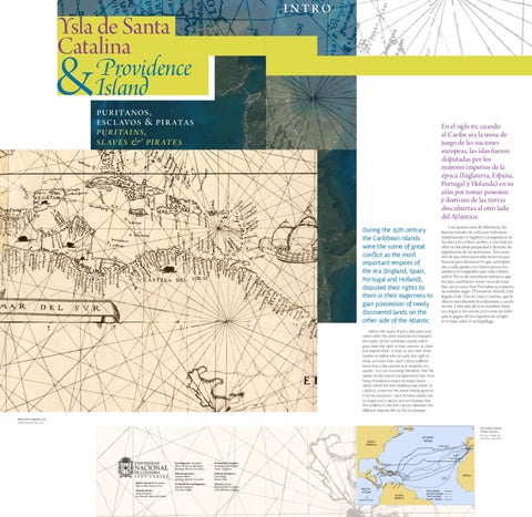
Con apenas años de diferencia, las fuerzas navales de cada uno realizaron exploraciones y registros cartográficos de las islas y las costas caribes, y con base en ellos reclamaban propiedad y derecho de explotación de los territorios. Tres tratados de paz internacionales tuvieron que hacerse para demarcar lo que correspondía a cada quién, y no fueron pocos los asaltos y reconquistas que cada colonia sufrió. No es de extrañarse entonces que las islas cambiaran varias veces de nombre; así es como hoy Providencia conserva su nombre anglo (Providence Island), y ha legado el de Ysla de Santa Catalina, que le dieron inicialmente los españoles, a su isla vecina. Cada uno de esos nombres tiene un origen y una razón, y es como un sello que la pugna de los imperios en el siglo xvii dejó sobre el archipiélago.
Within the space of just a few years one nation after the other explored and mapped the coasts of the Caribbean islands which gave them the right, in their opinion, to claim and exploit them. It took no less than three treaties to define who actually had right to what, and even then, each colony suffered more than a few attacks and renewed conquests. It is not surprising therefore, that the names of the islands changed more than once. Today Providence retains its Anglo-Saxon name, whilst the tiny neighbouring island, St. Catalina, conserves the name initially given to it by the Spaniards. Each of these names has an origin and a reason, and are stamps that the conflicts in the 17th century between the different empires left on the archipelago. Mapa oficial español, 1527. Official Spanish Map, 1527.
Los cuatro viajes de Colón, 1492-1503. The Four Voyages of Columbus, 1492-1503.
Investigación | Research Hazel Robinson Abrahams Santiago Moreno González
Traducción al inglés |
Edición general |
Edición de textos |
Translation into English
Annie Chapman
General edition
Text editing
Rector General | Principal Moisés Waserman Lerner
Asistente de investigación |
Director Sede |
Carolina Villate
Diseño | Design Patricia Melo González César Puertas Céspedes
Santiago Moreno González
Branch Director
José Ernesto Mancera Pineda
Research assitant
María Villa