April 2026, Issue #118
Connecting Communities Across Georgia along 342 Miles of Trails
Peachtree Creek Greenway See page 2
PATH Foundation A Non-Profit Organization Dedicated to Planning and Building Greenway Trails
Blueprints, Buffers & Bridges:
The Making of a Trail Local residents who were skeptical of the trail in the beginning, flock to it now for morning runs, nature walks, or to spend quality time with their families.
I
n 2017, city of Brookhaven officials came to PATH with a plan to build a trail down the Peachtree Creek corridor that would ultimately connect to the proposed Beltline trail. The partnership agreement resulting from the meeting had Brookhaven funding design and construction and PATH acting as project managers for the development of the trail. We went to our design consultants, KAIZEN Collaborative, and hired them to do construction drawings that were permittable and satisfied the city’s expectations. The city had specified a fourteen-foot-wide trail paralleling the creek; a feat in itself given the twenty-five-foot state stream buffer requirement and we had no idea where the property lines were. Greta deMayo and Nico Shen of KAIZEN were selected as the lead design
2 | PATHFoundation.org
consultants for the project. Moe Trebuchon was assigned by the city to be our point of contact. After walking the corridor with Greta, Nico and Moe, we realized the magnitude of restrictions that we faced long before construction could begin. There were flood studies to perform, property to obtain and a field survey to be completed before design could be initiated. We met with the adjacent property owners, obtained the necessary permits and hired a contractor. At first, the business park near the bridge was tepid, to say the least, toward the trail. After we began construction and the tenants started using the trail, they became more receptive. The finished trail is lit. There are three trailheads for users to access: just north of I-85 on
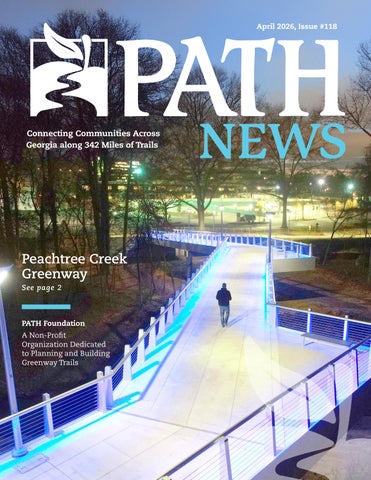
North Druid Hills, off Corporate Boulevard in the middle and Briarwood Road near REI at the northern end. The Salvation Army was a dream to work with establishing a trailhead at the southern end of the project and altering their main entrance to align with the existing traffic signal. Local residents who were skeptical of the trail in the beginning, flock to it now for morning runs, nature walks or to spend quality time with their families. The trail features an iconic bridge at the midpoint, a north Georgia mountain atmosphere and a safe environment for an intercity jog or walk. Recently, the city of Atlanta, the city of Brookhaven and PATH have an effort underway to extend the trail from North Druid Hills along the creek to PATH400 and the Beltline. l
April 2026 | 3
Improvements to the Chief Ladiga Trail
T
he Chief Ladiga Trail is the Alabama version of the Silver Comet Trail. It is built on the same abandoned railroad right-of-way as the Silver Comet, but in Alabama. You’ll notice a difference when you’re on the Chief: the surface changes from concrete to asphalt and the trail is two feet narrower than the Comet. The cites, counties and the Alabama DOT started building the Chief Ladiga Trail before PATH started building the Silver Comet Trail. They chose to build a ten-foot-wide asphalt trail for the economics, plus, it seemed like everyone was building ten-foot-wide asphalt trails at the time. They had no idea how popular it would be. For years, the Chief did not extend all the way to Anniston where the abandoned railroad right-of-way merges with the active railroad between Atlanta and Birmingham. The city of Anniston changed that in 2025 by purchasing the last seven miles of right-of-way with MPO funds (FHWA and ALDOT) plus a local match. The city of Anniston utilized local funding to complete construction of the Chief to the Amtrak station in downtown Anniston. It became a true century ride from Smyrna, Georgia to downtown Anniston. An abundance of trail users fantasize about a train ride one-way and taking the Chief-Comet back, but so far, Amtrak currently doesn’t share that fantasy. It’s Amtrak’s policy (union agreement) not to load and unload bikes at unmanned stations, however, they are reconsidering that position. More on the outcome of this exciting decision later. The Chief asphalt was partially resurfaced in 2025 through Cleburne and Calhoun counties as part of regular maintenance. Our Alabama partners had a busy year improving the Chief. l
4 | PATHFoundation.org
April 2026 | 5
PROJECT UPDATES PLANNING AND DESIGN Adams Park Trail (Aero ATL) This trail will connect Cascade Road to Campbellton Road via a 1.5-mile sidepath. The trail will run primarily along Delowe Drive providing access to Cascade Elementary, Adams Park and Alfred Tup Holmes Golf Course. Public meetings will be announced through the City of Atlanta DOT Communications team. Peachtree Creek Greenway This 0.7-mile segment will begin along the creek at the Atlanta/Brookhaven city limits connecting with Brookhaven’s segment 2 of the Peachtree Creek Greenway. It will follow the creek corridor, pass under Buford Highway, Cheshire Bridge Road and I-85 before linking to the existing Cheshire Farm Trail. Once complete, PATH400 and the Atlanta Beltline will be linked.
Proctor Creek 4 This trail is working through permitting at 60% design, with construction anticipated for the end of 2026. This 2.4-mile segment begins at West Highlands and ends at Lillian Cooper Shepherd Park. Southwest Beltline Connector 4 PATH is partnering with the Atlanta Beltline to connect the existing Southwest Beltline Connector and Lionel Hampton Trail to John A. White Park. This 1.1-mile segment reached 60% design and is in permitting. The City of Atlanta DOT Communications team will be scheduling an upcoming public meeting for more information. Details will be distributed over social media.
UNDER CONSTRUCTION
PATH400 Loridans to Sandy Springs PATH is honored to be partnering once again with Livable Buckhead for the Loridans Drive to Sandy Springs city limits segment of PATH400. This segment is making significant construction progress along GA400, as the switchback is taking shape next to the Loridans Drive Road bridge.
6 | PATHFoundation.org
Silver Comet Connector – Segments 2 & 3 These final/critical sections will link the recently completed MacArthur Boulevard segment to the existing Silver Comet Connector at the entrance to The Works to provide a direct connection to the Atlanta Beltline. Once complete, connectivity for trail users will expand across the region’s growing trail network. The project is on schedule for completion in August 2027.
Atlanta Riverlands This trail connects Standing Peachtree Greenspace to the Silver Comet Connector along Marietta Blvd. It will include a bridge at the confluence of Peachtree Creek and the Chattahoochee River. Completion is projected for the end of the year. l For more updates on Beltline projects scan this QR code.
ED’S
CORNER edwin@pathfoundation.org
Photo credit: Kelly Jordan
South River Beach
S
ometimes our best intensions end up being a dumpster fire. Such was the case when PATH saw the shoals and sand in the South River at the Snapfinger Road bridge and pictured a recreational venue (we needed to stick with building trails). The idea was to create an access to the beautiful rocks that form the shoals from the trailhead we were building. The river deposits sand naturally, so there would always be a ‘beach’ of sorts between the trailhead and the shoals. Without asking anyone at the County, we proceeded to create the venue in the river.
It was a hit with the surrounding neighborhoods! The Saturday after it was completed, you couldn’t see the shoals for the people. We had created utopia, so it appeared. Cars were lining both Panola and Snapfinger Roads cause we only had room for about fourteen spaces at the trailhead. Little did we know the river was unsafe due to high levels of E. coli. We had invited everyone to a beautiful spot that health officials had deemed unsafe. I arrived at my office to find several messages on my phone from the county, and the newspaper, asking for a quote. Evidently, they had pictures of our ‘venue’ in full use from
the previous Saturday and the reporter wondered why we would build a spot that would expose the users to E. coli. We were busy that Monday ripping out the access and apologizing to the county and the community. The county wasted no time in putting up signs warning people of the health hazards associated with getting in the water. Turns out that all that sand we saw as a beach was the county’s supply of sand. Moral to the story: Stick to what you know best. Don’t be distracted by shiny objects. l
April 2026 | 7
Presorted First-Class Mail U.S. Postage Paid Atlanta, GA Permit No. 8163
PATH Foundation 1601 West Peachtree Street Atlanta, GA 30309
PATH Foundation Board of Directors C. Austin Stephens, , Chairman Alexander C. Taylor, Vice Chairman Tree McGlown, Secretary Harry L. Anderson, Treasurer B. Harvey Hill, Jr. Jamie Hockin Ciannat Howett James C. Kennedy Sarah K. Kennedy Scott Kitchens E. Cody Laird, Jr. Stephen Lanier Lyle Ross R. Charles Shufeldt
John W. Somerhalder II Stephanie Stephens Richard Tyler Lauren Wilson W. Douglas Ellis, Jr., Emeritus William C. Fowler, Emeritus Carol Muldawer, Emeritus Greta deMayo, Executive Director Ed McBrayer, Executive Advisor
Cover Photo: Lighted bridge at Peachtree Creek Greenway
Follow us on Facebook and Instagram and visit our website at pathfoundation.org.