7 minute read
Adventure Travel: A West Coast Tale


A WEST COAST TALE FIVE FRIENDS FOR SEVEN DAYS ON THE PACIFIC RIM
By Jenna Thompson
Advertisement
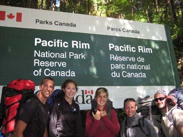
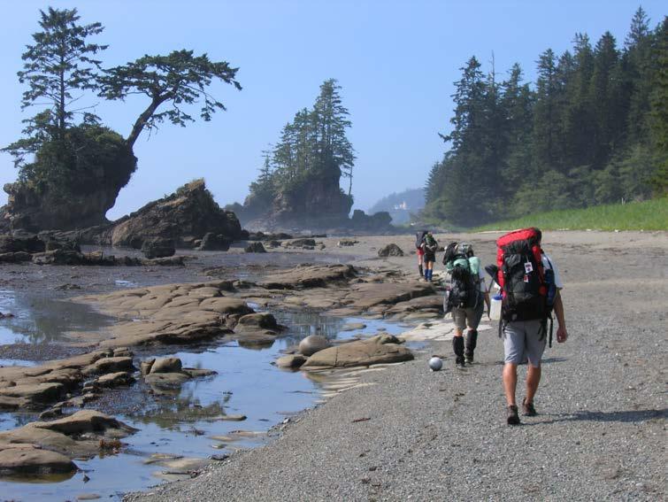
Two trailheads—Gordon River in the north, Pachena at the south end – invited five hikers into a 75-kilometre trek either direction along the southwestern coast of Vancouver Island.
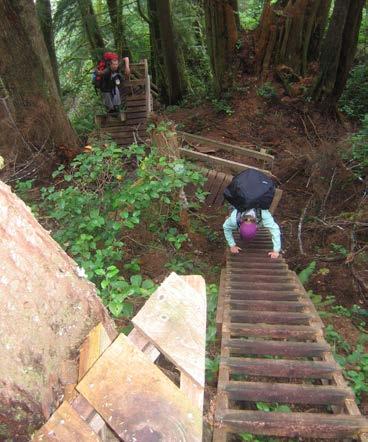
On this August adventure we encountered mud, tree roots, unpredictable weather and magnificent isolated shoreline. There were lighthouses, dangerous surge channels, suspension bridges and cable cars. There are ladders and more ladders to help in the really hard parts, but they don’t head off the blisters and backaches.
This is the stuff the West Coast Trail in Pacific Rim National Park. One of the best hikes in Canada, it follows an old telegraph line that helped shipwreck survivors along “the Graveyard of the Pacific.” Thousands of hikers from around the world tackle it every year.
We attended mandatory orientation with about 20 other hikers before setting out from Gordon River to our first stop at Thrasher Cove. The notice board told us there had been 46 evacuations for medical conditions and injuries already that. (But Parks Canada won’t send a boat to take you off the trail it you’re just exhausted or out of food.)
The staff also told us about tsunami warning signals like an earthquake or suddenly reced
ing sea water and the urgent necessity to get to high ground fast.
When trail school was finished the five of us boarded the ferry across Gordon River to the south trailhead.
After months of preparation and flying all the way from Ontario just to do this hike, we were giddy with eagerness to be finally there. Since hikers can start at the north or the south end, we met people coming the other way, nearing the end of their hike. We wondered what they thought of our bright eyes, big smiles and clean clothes; the way they looked was what we might look like in seven days.
Along the trail we came upon a rusting donkey engine from the trail’s logging days and climbed the first of the many wooden ladders
to help hikers handle the rugged terrain. We spent our first night at Thrasher Cove, soaking in the last sunshine before our beach campsite fell into shadow.
Then it was early to bed – tomorrow would be a long day. In the night we heard a commotion from nearby campers who learned the hard way to pitch their tent above the high tide line.
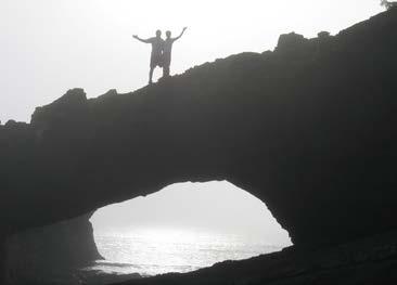
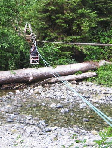
On our second day we planned to hike from Thrasher Cove to Cullite Creek, so we were up before the sun at 4 a.m. We chose the beach route instead of the inland route for this section, which meant timing our trek to match low tide (tide tables are a must on the trail). The beach route was a wonderful choice. The first section is full of boulders, “as big as houses” some said, and we could explore the caves at Owen Point, accessible only at low tide. Then we got to the first of the trail’s cable cars, loaded ourselves and gear aboard, and rode across the stream – almost like ziplining!
In one section we were atop cliffs looking down at the water, with lush, ferny forest close to the cliff edge. Here the trail was muddy, and we all went ker-splut into it at least once before reaching Cullite Cove. It forms a sort of amphitheatre facing the ocean. with rock walls on each side amplifying the crashing of the waves into an awesome orchestra. From that sublime experience, we moved onto the banal as departing campers warning us to hang up our gear to avoid mice. One friend didn’t, and found her toilet paper chewed to bits the next morning.
On the third day, heading to Carmanah Point from Cullite Cove, we had heard there might be a bear in the area, so we sang pop songs enthusiastically to keep it at bay. We saw no bears, but wildlife was abundant: thousands of gulls on the beach, a squadron of pelicans cruising by, tidal pools teeming with marine critters, and seals, sea lions and deer along the way. After some boardwalk bog-walking and more ladders, we had the right tide timing to continue along the beach.
Hiking the beach is a neat idea (this is the coast after all), but we learned quickly that walking on sand is a struggle, and slow. Boots sink in with every step, and the weight of a pack is no help.
We camped at Carmanah because it’s near Monique, the doyen of the trail. Monique, whose husband is a member of the Ditidaht first nation, has set up a “restaurant” of sorts (a tarp structure with patio furniture) on the trail, and the couple boat in supplies and food from Port Renfrew. We were willing to pay any price for fresh edibles, and a can of Kokanee beer had never tasted so good.
On day four to Tsusiat I was sore enough that I really didn’t want to move, let alone hike. I regretted bringing a cheap blue foam pad instead of a proper Thermarest. We made a repeat visit to Monique for breakfast, and her eggs, toast and hash browns fueled us for the morning.
We climbed the hill to check out Carmanah lighthouse, then trekked on through mud, bridges, broken boardwalks and tangled tree roots. At Nitinat Narrows, the only way across a creek was a Ditidaht-run ferry, but we delayed boarding until after feasting on some local fresh crab.
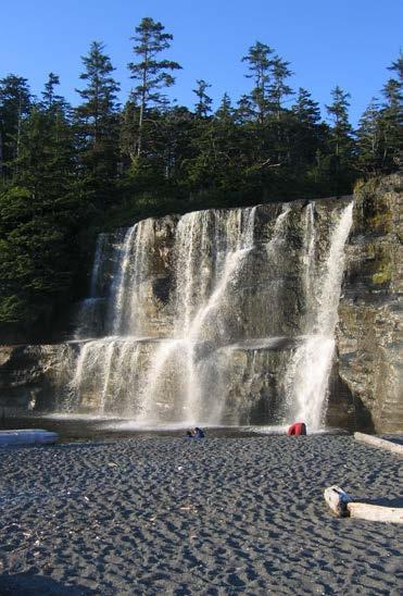
I had my first blister and was limping, but it seemed worth it when we got to Tsusiat Falls where a sheet of water cascades over a 10-metre cliff. This had been our longest and hardest day at 21 kilometres.
Despite the aches and pains, we were ahead of schedule and stayed in camp on our fifth day to relax and enjoy the falls. But clouds and fog rolled in and we spent the day confined to our tents with the distinct smell of sweaty, dirty hikers. So under the falls we went for a shower. It was freezing!
Since we were near trail’s end, we figured out how much food we would need and ate the rest – we had been rationing carefully and didn’t want to carry more than necessary. That night we enjoyed our first campfire with hot chocolate and popcorn – downright luxurious.
On day six we hit the trail again from Tsusiat to Michigan, and I was hurting everywhere, especially the soles of my feet. Though the trail was noticeably easier at this end, we were exhausted. When we got to the Michigan camping area, it was covered with beach buoys that people have found and carved. I found one on the shore and carved our names in it with my Swiss Army knife.
On our last day to the Pachena trailhead we were in rainforest, with the key word being rain. We’d been lucky with a week of beautiful sunshine and only half a day of light rain. Most West Coast Trail stories involve rain and mud and we wondered if we needed to hike the whole thing again to get the authentic experience. Uh, not right away – my pack felt like it was full of bricks. Everyone was in high spirits and we could taste the beer and hot food, and feel the warm showers and soft mattresses coming our way.
This was the first major backpacking trip for three of our hikers. But everyone was very fit, and my spouse and I made sure they were properly equipped and knew what to expect. That said, my advice for anyone thinking about the West Coast Trail is try a two- to three-day overnight hike ahead of time to figure out what gear you need, and don’t need, and to make sure you have the stamina.
Then go for it.
The West Coast Trail is open May 1 to Sept. 30. Make reservations well in advance.
More information is a www.pc.gc.ca/eng/pnnp/bc/pacificrim/index.aspx.