3 minute read
HOW HAVE MAPS BEEN USED AS A POLITICAL VEHICLE?


Andrea Thordarson (WHS)
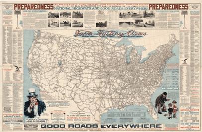
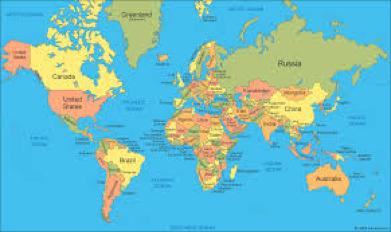
Maps have been present in many cultures over many years. They share the common purpose of depicting the many geographical features of an area and are regarded as honest and objective fact. From an early age one is taught to trust and follow maps and not question what is written. This is what makes them such a powerful political tool. Maps are used to display a wide variety of factors and each has a unique purpose. Some show only a small area but in immense detail where every road, building and pond is named. Others such as our world map present us with a view of each key city and the borders between countries. Over time many people have used cartography to influence the minds of others. For example, in the light of the new green movement a government may choose to minimise or leave off large factories and other pollutants, or a small town seeking an increase in tourism may emphasise the more desirable factors such as a forest or a fairground. When you go to a theme park you are often presented with a map, cartoonishly drawn where your eye darts unable to choose which attraction to visit first. The human brain is impressionable, and while a tourism agenda may not pose much threat, this ‘persuasive cartography’ can have a far more dangerous reach in the hands of those leading a country. One of the most common alterations to maps made is changing the apparent sizing of each country. Take for example what we would regard as the regular world map. Although this is widely seen as an accurate representation of our world, we have come to discover that it is a fallacy. This version of a world map was drawn up in 1569 by a Flemish man named Gerardus Mercator. At the time of its making, Europe had begun to become a continent of empires. As France, Britain, the Netherlands and other European nations begun to expand in all directions, seeking lucrative trade and foreign lands, cartography was in high demand. Imperialists being as they are, took the chance to create a completely Eurocentric map. We see Europe sat right in the middle, Greenland of a similar size to Africa, swathes of land taken up by North America and land mass seemingly increasing the further north you reach. In reality Greenland is 14 times smaller than Africa and three times smaller than Australia . In fact were the countries in the northern hemisphere drawn to the same scale as the countries nearest to the equator, you would see a massive decrease in size. Another cartographic alteration is the purposeful highlighting of certain aspects of a country’s geography or infrastructure. For example, in the early 20th century America, a map was produced focusing only on the roads present at the time. It served to show the public how they were significantly lacking connecting roads between the states as well as the urban and the rural. They emphasised this as an issue declaring the US vulnerable in war and at a great economic disadvantage should this lack of interconnectivity continue.
Advertisement
This specific form of manipulation is also apparent more subtly in a vast number of maps. Places that inspire national unity such as those with historic value (the trenches in which the battle of the Somme took place and other monuments) are most often included on maps where less pleasing aspects, for instance toxic waste facilities or abandoned buildings are left off. Finally, in a more blatant display of propaganda, all through the various conflicts of the 20th century artistic alterations to maps would be made. During the Cold war Russia would be coloured in bright red clearly highlighting the country and its size, seeking to inspire fear within Americans and garnering support for the anti-Soviet campaigns of the time. Depictions of countries as animals, specific examples of Britain as a spider or octopus, attempting to wrap around its African colonies, or in the first world war, around Europe saw to portray the UK as a power hungry, devious and egotistical power. Below is a map of Europe in the first world war. Each Nation a dog, all aimed at the threat of Germany and Austria-Hungary. The triple entente: strong dogs aided by a steam roller, menacing and surrounding the threat: two small dogs, wide eyed and fearful. During times where the most common dispute