7 minute read
WHAT ROLE DO MAPS PLAY IN CLASSIC CHILDREN’S BOOKS?


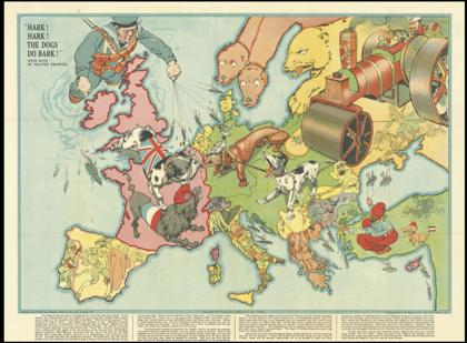
was that over borders, it comes as no surprise that cartographic propaganda ran rampant.
Although many use them regularly, maps are not something most spend much time questioning. That is exactly what makes them such an efficient and easily used political vehicle. We trust what is given to us and rarely ask further questions and as a result we have been influenced into the hatred of nations overseas, overlooked the darker sides of our countries and have relied on an inaccurate world map for nearly 500 years.
Advertisement
Lizzie Caird (OHS)
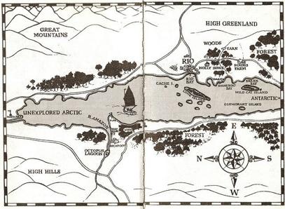
In many ways, cartographers and authors share a similar mission; both create forms of artwork, one could argue, that tell a story and provide the possibility for adventure. Despite the practical aspects of maps for navigation, they shape journeys that happen in our everyday lives and in the lives of book characters. In the context of books, maps provide the reader with both a sense of reality and fantasy. It is this transformative quality that maps offer that make them a key component of many classic children’s stories, carrying the plot and adding dimensions to the written world. Maps appear throughout literature, cutting past genre boundaries and age-groups, in books such as the Harry Potter series, with the Marauder’s Map, Twenty Thousand Leagues Under the Sea, by Jules Verne, and Moby Dick, by Herman Melville. There is a complex myriad of reasons for why authors include maps in their books, with the obvious motive of mapping a physical journey taken by characters. However, I want to explore the entire role that maps play in the classic children’s stories of Winnie the Pooh, by A.A. Milne, Swallows and Amazons, by Arthur Ransome, and The Narnia Chronicles, by C.S. Lewis. In Winnie the Pooh, by A.A. Milne, the iconic sketchy map of the Hundred Acre Wood, which is based on the landscapes of the Five Hundred Acre Wood in Ashdown Forest, East Sussex, plays more of a role in depicting the relationships between characters and the size and scope of Christopher Robin’s world, rather than a major journey that is undertaken. This map’s perspective is solely from that of a child’s, being ‘drawn by me’, voicing Christopher Robin, and adding that ‘Mr Shepard helpd’ referring to E.H. Shepard, the illustrator. This is also evident due to the spelling mistakes that scatter the map, including ‘big stones and rox’ and ‘rabbits friends and raletions’, giving it a more relatable meaning for children, and an endearing touch for adult readers. The effect of this child’s viewpoint transforms evident fantasy, detailed by ‘heffalumps’ and ‘the wozzle’, into childish reality. Furthermore, this map helps the reader to understand the importance of each landmark, which would seem indifferent to any passer-by, thus immersing the reader in the microscopic woodland world. True magic is created by the idea of a familiar landscape to all humans, in this case a standard wood, becoming the home to much-loved animal characters, giving an ordinary landscape meaningful value. When assessing the nature of Winnie the Pooh, which is written in snippet-like chapters, covering different adventures, perhaps the mapping of the Hundred Acre Wood could be considered to ground a familiar fictional space that could be endless, thus simply assisting the narrative to flow and connect. Therefore, the map centralises the story, providing the reader with a perception of scale, and preventing the stories from being entirely intangible. Similar to Winnie the Pooh’s basis on reality, Swallows and Amazons covers a fantastical version of the land that Arthur Ransome, the author, explored as a child, in the Lake District. Of course, the map in Swallows and Amazons shows the journeys and adventures that the Walker children take, therefore providing a more practical use. However, what is particularly evident in these maps is the childish simplification of unknown territory, contrasting with the detailed and personal nature of homeland. For example, by labelling ‘Great Mountains’ on the map, it is clear that the Walker children view the Lake District mountains that tower over the lake, a conglomeration of Windermere and Coniston, as unsurveyed, faraway land. In contrast, the area around their very own ‘Wild Cat Island’ is detailed with the names of bays and ‘native settlements’. This is a direct reflection of a child’s imagination, embellishing the familiar environment and simplifying the intimidating ‘unknown’. This is also evident in the fact that both Winnie the Pooh and Swallows and Amazons include references to the North Pole, acting as an impalpable location as the pinnacle of unexplored territory for children.


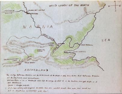
Ransome’s personal experiences from his childhood, that underlie throughout the story, such as the naming of his favourite yacht ‘Nancy Blackett’, blurs any boundaries between the book and his own imagination. This caused him difficulty in accepting Stephen Spurrier’s original map illustrations, which did not embody his personal picture of the landscape spurring him to create his own maps in future. This links to a possible limitation of adding maps to a piece of children’s literature, simply that they can restrict the reader’s imagination. When reading books as a child, it is common for each individual to interpret the story in a slightly different way, perhaps visualising the characters in a particular manner, or perceiving the morals independently. Therefore by introducing a physical map, the reader’s vast imagination is confined to the limits of the map, forcing them to conform to the author’s concept. This strong contrast between a sense of freedom and conformity links to the opportunities that maps offer children, which is particularly evident in Swallows and Amazons. In some ways, the children are able to invent their own lands, resulting in fictional maps such as the one Ransome creates for the Walker children. Furthermore, this means that one is not restricted by the rapidly changing ‘real’ world, with shifting demographics and evolving geographies, which was a particular concern for children living in the aftermath of World War I, which is when Swallows and Amazons was published. On the other hand, maps provide children with boundaries, meaning there are challenges to face and obstacles to overcome. For example, the shape of Wild Cat Island, with its indented shoreline, makes it impossible normally to beach the Swallow in their hidden harbour when sailing at night. Therefore, a solution is required, resulting in the realisation that the ‘Amazons can come into the harbour without bothering about the rocks by keeping those two in line’, when referring to the white crosses on the tree stumps, providing children with scope to invent and resolve. Contrary to Ransome’s difficulty in grasping the conception of an illustrator, Pauline Baynes, who illustrated the maps for the Narnia chronicles, expanded the land of Narnia and liberated the characters’ adventures. Lewis said that he wanted his map to ‘be more like a medieval map than an Ordnance Survey with mountains and castles drawn - perhaps winds blowing at the corners - and a few heraldic-looking ships, whales and dolphins in the sea’, something he felt he himself couldn’t depict with his simple line sketches. Therefore, Pauline Baynes’ illustration broadened the boundaries of Narnia, adding depth and dimension to the plot, and Lewis was able to adapt his personal perspective, allowing broad-mindedness. Rather than the restriction of the reader’s imagination, as the maps of books such as Swallows and Amazons could sometimes be considered to foster, the Narnia maps assist both the reader and, presumably, the author in grasping the progress of the plot in such a fantastical world. As J.R.R. Tolkein, who was a close friend of Lewis’, declared, “if you’re going to have a complicated story you must work to a map, otherwise you’ll never make a map of it afterwards”, thus observing the need for geographical support when dealing with a fantasy world. Overall, maps do play a vital role in classic children’s books, detailing a childish sense of imagination and centralising the story. Maps can both restrict and broaden a child’s perception of a particular book, but undoubtedly ground the plot in a tangible setting. When looking at maps in children’s books, one can certainly see the connection between cartographers and authors, inspiring the reader to make an adventure, whether physically, in one’s imagination, or emotionally, bringing worlds, both real and fictional, to life.
Bibliography Lewis-Jones, H. et al. (2018). The Writer’s Map. London: Thames and Hudson Ltd Photo Sources [1] Sotheby’s on BBC News (https://www.bbc.co.uk/ news/uk-england-sussex-44781752) [2] Google on Pinterest (https://www.pinterest.co.uk/ pin/415668240600255017/) [3] Lancaster University Digital Humanities Hub (http://wp.lancs.ac.uk/dighum/2016/09/13/readingand-mapping-swallows-and-amazons/) [4] Pauline Baynes, contributed by Alberto Ceccatelli (https://www.paulinebaynes. com/?what=artifacts&image_id=495) [5] Bodlein Libraries (https://bodleianlibs.tumblr.com/ post/168008344675/know-your-way-around-narnia)