4 minute read
On the Water


© OCEANA |Carlos Suárez
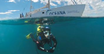
Oceana launched expeditions in two hemispheres in 2010, including a research expedition in the Gulf of Mexico following the BP oil spill. Oceana expeditions gather the photos, video and science needed to bring the oceans to life and to make policy change possible. Our expedition with National Geographic to Chile’s remote Sala y Gómez Island pushed for the creation of an enormous marine protected area around the island. The Ranger completed another successful summer voyage to the Western Mediterranean to document habitats at risk, and Oceana made several return trips to Chilean Patagonia to document the biodiversity of the region.
ThE OCEAnA lATITudE TAkES STOCk Of ThE gulf Of MExICO OIl SPIll
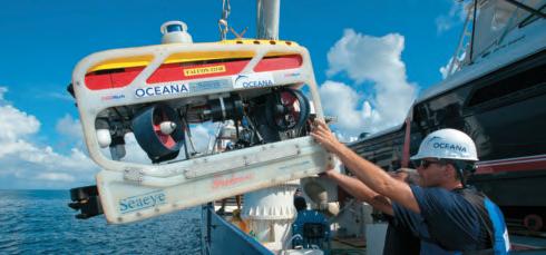
As oil continued to gush from the Macondo well in the Gulf of Mexico in August, Oceana launched a two-month research expedition in the Gulf to assess the long-term impacts of the oil spill.
It was an international expedition, led by Oceana’s vice president for Europe, Xavier Pastor and Oceana’s chief scientist and vice president for North America, Mike Hirshfield, and it included scientists, divers and underwater photographers from Oceana’s U.S., Chile and Spain offices, as well as academic scientists.
The expedition, which took place aboard the 170-foot Oceana Latitude, included research by Dr. Jeff Short, Oceana’s Pacific science director and one of the world’s leading experts on Exxon Valdez and the effects of oil spills. Dr. Short designed an experiment using cutting-edge science to map the subsurface oil plume.
The Latitude crew also studied important seafloor habitats as well as the marine life affected by the spill. The team took samples of water, fish larvae, plankton and adult fish, and tagged several shark species to monitor their migration patterns and study their ability to avoid oiled areas.
ThE OCEAnA RAngER PROTECTS ThREATEnEd CORAlS In ThE WESTERn MEdITERRAnEAn
For its annual expedition, Oceana’s research catamaran, the Ranger, sailed to the Western Mediterranean to get the evidence needed to protect marine areas of ecological interest.
Using an underwater robot, the groups recorded the first ever high-definition images of the seabed, more than 300 feet deep. This reef, discovered by Oceana at depths up to 1,500 feet, has turned out to be one of the most important in the Mediterranean.
Most of the Mediterranean’s deep-sea coral reefs have been destroyed by bottom trawling and longline fishing. The Ranger’s discoveries will inform Oceana’s proposal to protect this area by including it in the Natura 2000 Network of the European Union.
ExPlORIng And SAVIng A PACIfIC gEM: SAlA y góMEz ISlAnd
In March, Oceana teamed up with National Geographic and the Waitt Foundation in an expedition to Chile’s Sala y Gómez Island, an uninhabited Chilean island 250 miles east of Easter Island in the Pacific Ocean as part of the campaign to establish one of the world’s largest no-take marine reserves.
The scientists on the expedition noted that the little-studied ecosystem contained a great abundance of marine wildlife, including populations of vulnerable species such as sharks and lobsters. In addition, the scientists found unexpectedly high biodiversity in deeper waters. Using an underwater robot, the groups recorded the first ever high-definition images of the seabed, more than 3,000 feet deep.
After the expedition, Oceana and National Geographic presented a proposal to Chilean President Sebastián Piñera advocating the protection of the waters around the island. In October, President Piñera announced the creation of the Sala y Gómez Marine Park, a no-take marine reserve of 150,000
square kilometers around the island, an area roughly the size of Greece. This new park expands Chile’s total marine protected area more than 100 times, from the previous 0.03 percent to 4.41 percent of Chile’s waters and is the fourth largest no-take reserve in the world.
Oceana and National Geographic are planning a follow-up expedition to Sala y Gómez in 2011.
GATHERInG EVIdEnCE TO PROTECT PATAGOnIAn FJORds And sEAs
As a part of Oceana’s ongoing goal to create a marine protected area in Patagonia in southern Chile, in early 2010, Oceana completed several expeditions to the small village of Tortel, where the crew obtained high-definition footage and photographs of underwater habitats.
In addition, Oceana traveled to the southern Patagonian region of Magallanes, which we are working to defend from the negative impacts of salmon farming. The team documented the rich biodiversity of the cold-water fjords, including underwater photos and video. The crew obtained footage of the seabed beneath an abandoned salmon farm, graphically illustrating the environmental impacts of the industry.
© OCEANA |Enrique Talledo
CLEAnInG UP THE AFTERMATH OF TsUnAMI In CHILE’s HARd-HIT JUAn FERnándEz IsLAnds
The 8.8-magnitude earthquake and subsequent tsunami that struck Chile in February were devastating to the Juan Fernández Islands, where Oceana has been working with local communities to protect their marine resources. Artisanal fishing is a critical part of the local economy, and Oceana’s contribution to the clean-up helped get the residents of Juan Fernández back on their feet after the historic earthquale.
Oceana organized a clean-up campaign with two local groups, the Juan Fernández Archipelago Foundation and the Robinson Crusoe Island Artisanal Fishermen’s Union. In September, they began the task of clearing the underwater wreckage left by the tsunami. As of December, the clean-up divers had removed nearly six tons of debris, including metal fences, clothing, kitchen appliances and furniture. After Oceana’s expedition to Sala y Gómez Island, the government of Chile announced the world’s fourth-largest no-take zone around the isolated island - protecting an untouched gem for future generations.
Opposite page: Crew members work with the ROV on the Oceana Latitude. Bottom left: The Oceana Ranger in the Mediterranean. Bottom right: The Oceana Latitude.


