4 minute read
Kitikmeot Region

Kitikmeot Kitikmeot Region Region
Time Zone: Mountain Population: 7,098
KUGAARUK • ᑰᒑᕐᔪᒃ
“little stream” Population: 1,108 Inuit in the Kugaaruk area specialize in making qayaq (kayak) and Elders today still teach the younger generations the proper way to construct them. The community is found near some of the most important bowhead whale habitats in the territory and visitors can book a sea kayak tour to paddle along the Gulf of Boothia to witness these whales, as well as seals and walrus.
GJOA HAVEN • ᐅᖅᓱᖅᑑᖅ
Uqsuqtuuq - “lots of fat” Population: 1,410 Gjoa Haven was named after a ship called the Gjoa, which was used by Norwegian explorer Roald Amundsen who was the first to successfully traverse the Northwest Passage in 1906. The community is located on King William Island, which is famous in its own right for its role in the Franklin Expedition. Visitors can set aside time to explore the hamlet and read information plaques that explain the role Inuit played in helping explorers over the centuries. The Northwest Passage Territorial Trail is a walking tour that tells the stories of dozens of European explorers who desperately wanted to find the Northwest Passage and locate the lost Franklin expedition.
TALOYOAK • ᑕᓗᕐᔪᐊᕐᒃ
Talurjuaq - “large caribou hunting blind” Population: 1,144 Taloyoak has the unique distinction of being the northernmost community on Canada’s mainland. It has long been an important destination for explorers navigating the Northwest Passage due to its location on the south coast of the Boothia Peninsula. Trails leading from the community reveal prime fishing spots and hunting areas.
Traditional clothing here is different than in other Nunavut communities and women’s amauti are often beaded and brightly decorated. Taloyoak is also known for its “packing dolls,” which depict animals carrying their young in amauti. Artists often create carvings from stone, whalebone, caribou antler and walrus ivory.
KUGLUKTUK • ᖁᕐᓗᖅᑐᖅ
Qurluktuk - “the place of moving water” Population: 1,607 North of the Arctic Circle you’ll find Kugluktuk. Formerly named after the Coppermine River, this community is found just north of the border between Nunavut and the Northwest Territories and is known to have the warmest summer temperatures in the territory – sometimes reaching 30 C. Kugluktuk was an important area for the Copper Inuit, who created tools and decorations using the region’s copper deposits. The Inuit of Kugluktuk speak Inuinnaqtun — a slightly different language from Inuktitut — K because they are Copper Inuit people, descendants of the ancient Thule with distinct cultural traditions. Local hunters harvest barren-ground grizzly bears, caribou and ringed seal. Kugluk (Bloody Falls) Territorial Park features 25 acres of terrain near the waterfalls of the Coppermine River where it narrows into a cascade of swirling water. It was designated a National Historic Site in 1978. The Inuinnaqtun name Kugluk means waterfall and the campsite below the falls is called Onoagahiovik, meaning ‘the place where you stay all night’ because the fishing is so good – not a surprise around here.
e v in T Klengenberg Photo
UMINGMAKTOK
“they caught a muskox” Population: 0 (as of 2016 Census) This tiny community, periodically inhabited, is located at the site of an abandoned Hudson’s Bay Company post in Bathurst Inlet. Inuit moved here seeking to return to a traditional way of life, and the community is sustained by the area’s abundant wildlife which includes caribou, muskoxen, wolves, grizzly bears and seals.
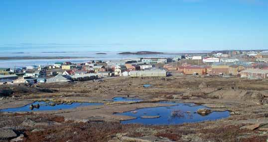


CAMBRIDGE BAY ᐃᖃᓗᒃᑑᑦᑎᐊᖅ
Iqaluktuuttiak - “good fishing place” Population: 1,829 Cambridge Bay is the largest community and administrative centre for the Kitikmeot region. A regional hub, it acts as a stopover point for travellers heading to Yellowknife and farther south.
Archaeological sites indicate the area has been inhabited for 4,000 years. More modern history includes stories of building a Catholic church in 1954 using seal oil and sand as mortar.
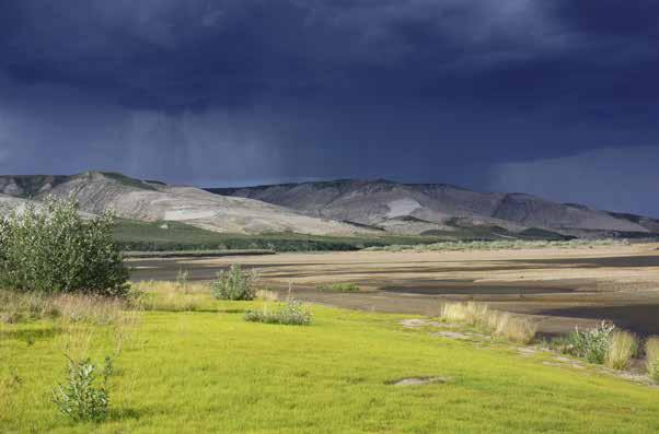
The community is on the southeast coast of Victoria Island and is an important point for vessels travelling the Northwest Passage. Cruise ships stop here to experience a hint of Arctic life. Anglers can catch giant Arctic char in the Ekalluk River, and local hunters harvest caribou and muskoxen.
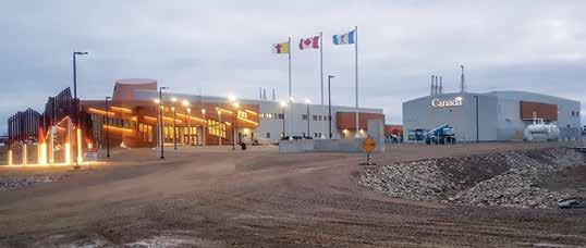
Cambridge Bay is home to the Canadian High Arctic Research Station, which attracts scientists and researchers from across the world.
Ovayok Territorial Park is home to an important landmark called Ovayok Mountain (Mount Pelly) that rises from the landscape. There are trails through untouched Arctic wilderness, with designated camping areas and historic sites. The park is also home to herds of muskoxen and lakes full of fish and waterfowl.