
5 minute read
News in brief


MINING THE DATA
Growing demand for advanced computing techniques to support next generation research has prompted NIWA to establish a new data science team. Researchers are increasingly turning to advanced data capabilities to help analyse the rapidly-growing wave of information flowing in from NIWA’s environmental monitoring networks. The new data experts will work within the Technology and Innovation Group, with a particular focus on machine learning, artificial intelligence, optical recognition and digital twin technologies. The eight-strong team will be supported by NIWA’s existing High Performance Computing Facility and integrate data science across the climate, freshwater and marine research programmes.
Advertisement
DEEP DOWNLOAD
A state-of-the-art remotely operated vehicle (ROV) has recovered new data about New Zealand’s largest earthquake fault from the seabed o the North Island’s east coast. The three-tonne Canadian ROV was deployed from NIWA’s research vessel Tangaroa, as part of a joint NIWA, GNS Science and University of Washington investigation. The ROV successfully downloaded data along the Hikurangi subduction zone from equipment on two observation platforms installed 400m below the sea surface. The platforms have been continuously recording movement and slow slip earthquakes along the subduction zone for the past two years, and their data will provide fresh insight into the region’s seismic activity.
Lana Young

UNDER WE GO
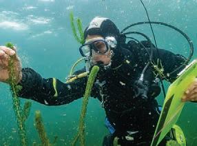
NIWA’s scientific divers successfully completed 2,471 dives in the past 12 months, spending a total of 42,593 minutes – or almost 30 days – underwater. NIWA has one of the largest specialist dive teams in New Zealand with 39 divers working across the marine and freshwater research platforms. Operations range throughout New Zealand, as far north as the Kermadec Islands, down to expeditions under the ice in Antarctica. A large proportion of the work involves ecological monitoring, along with ongoing biosecurity surveys checking for invasive pests and plants in harbours, ports, rivers and lakes.
NZ Story
WAVE THREATS

NIWA coastal researchers are working with residents to help refine advanced models for large wave events along Wellington’s south coast. The move follows a large southerly storm that swept into Wellington in late June bringing waves of more than 6m in Cook Strait. (See p.17) Emergency managers decided to evacuate some residents after considering factors, including modelling results, which indicated a potential threat to life and properties in worst case scenarios. Scientists are continuing to work with residents, gathering recent photos and experience of previous large storms, to update models for future events.

PLASTIC PATHWAYS
Research has revealed that microplastic fragments can find their way through the gut lining and into muscle tissue of New Zealand fish. Two experiments were carried out by students from the joint NIWA/ University of Auckland Institute of Aquatic and Atmospheric Science. The first surveyed six fish species commonly found in the Hauraki Gulf: snapper, yellowbelly flounder, gurnard, jack mackerel, kahawai and pilchard. Microplastics were found in the guts of 25 percent of fish sampled. A separate experiment also found traces of microplastics in the muscle tissue of snapper that had been fed high concentrations of polystyrene microplastics.
PLAYING WITH THE WIND
A NIWA climate scientist is combining work and a sporting interest to benefit golfers throughout New Zealand. Wind speed is a key factor in determining the di culty rating of each course, which is then used when calculating player handicaps. A higher average wind speed makes a course more di cult to play. However, applying consistent daily wind speeds to a huge variety of courses has been a long-term challenge for Golf NZ and widely debated by players. Meteorologist Dr Richard Turner is currently working with Golf New Zealand on a nationwide reassessment of almost 400 golf course ratings using NIWA’s in-house high resolution weather model. The new course ratings – and hopefully an end to the debates – are expected soon.
Nava Fadae
SNOW RECRUITS


Ski fi eld workers and alpine professionals have been recruited this winter to help with new research tracking the fate of snowmelt from our mountains. The Aotearoa Snow Isotope Project aims to determine the amount of meltwater making its way down from alpine snowfi elds into South Island rivers and aquifers. NIWA hydrologists have asked those regularly spending time in the snow, such as ski fi eld sta , mountain guides or back country professionals, to take small weekly snow samples this winter and send them in for analysis. Isotopic readings from both snow and downstream water samples can help determine where snowmelt comes from and how much ends up in our rivers. Snowmelt is crucial for industries such as agriculture and hydro generation, and researchers want to understand the impacts of climate change on water fl ows.

METHANE TRACKING
NIWA atmospheric scientists will play a key role in a new international space mission tracking methane emissions around the globe. The joint United States-New Zealand project involves the American launch of a methane-sensing satellite which will be operated from a New Zealand-based mission control centre. The initial focus of the $150 million collaboration will be to gather data to identify methane emissions from oil and gas operations around the world. A multi-disciplinary research team led by NIWA’s Dr Sara Mikalo -Fletcher will also use MethaneSAT to help quantify agricultural greenhouse gas emissions. The international joint venture aims to help counter climate change by encouraging global strategies for reducing methane emissions.
MethaneSAT
RAIN ON THE PLAINS

NIWA fi eld teams and hydrologists sprang into action during the prodigious rainmaker event that hit Canterbury at the end of May. A concentrated fl ume of moist air coming in from the north brought intense rainfall for the Canterbury foothills, closing roads and sending fl oodwaters surging across large areas of downstream farmland. Field monitoring teams were quickly deployed across the region, gathering observations and fl ow gauging measurements. A record 526mm of rain fell at Mount Somers over 48 hours and the Ashburton River peaked at about 250 times above normal fl ow. Data gathered will help engineers and planners design the infrastructure needed to cope with extreme events in the future.

Handheld fl ow gauging sensor in use on the Ashburton River. (Alec Dempster)
Marty Flanagan


