
5 minute read
II.2.a. Site’s Observation


When I concentrate on a specific site or place for which I am going to design a building, I try to plumb its depths, its form67 ... PETER ZUMTHOR
INTRODUCTION In this section, we will dive into a more detailed analysis of the site in order to identify the on-sitematerial that will help us design the project with a more cautious approach so that it is well integrated into its surroundings.
Advertisement
Summers in Ain Kanassira are short, hot, dry, and clear, while winters are long, cold, windy, and partially cloudy. Throughout the year, the temperature ranges from 8°C to 32°C, with temperatures rarely falling below 5°C or rising above 35°C. The hot season lasts three months, from June 21 to September 16, with an average daily high temperature above 28°C. August is the hottest month with average highs of 31°C and lows of 22°C. From November 27 to March 26, the cool season lasts four months, with an average daily maximum temperature of less than 18°C. January is the coldest month in Ain Kanassira, with an average low of 8°C and a high of 15°C.
The daily average high (red line) and low (blue line) temperature
A/ Average Temperature in Ain Kanassira :

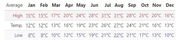
Figure n°168: Average High and Low Temperature in Ain Kanassira (Source weatherspark.com )
Conserving Ain Kanassira’s Resources Page
B/ Rainfall :
From August 21 to June 6, the rainy season lasts 9.5 months, with a typical 31-day rainfall of at least 13 millimeters*. October is the wettest month in AinKanassira with an average rainfall of 37 millimeters. The year's rainless season lasts 2.5 months, from June 6 to August 21. July has the least rain with an average rainfall of 4 millimeters.
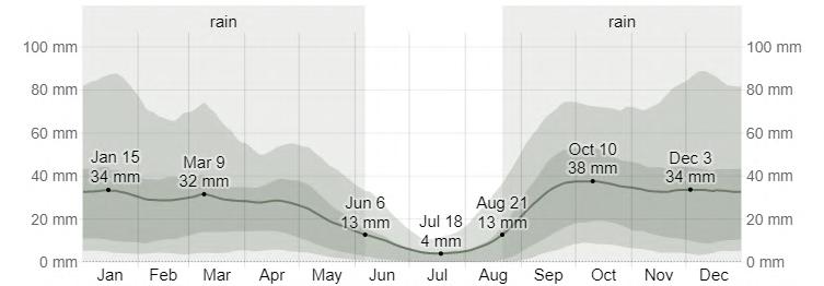
Figure n°170: Average Monthly Rainfall in Ain Kanassira (Source weatherspark.com )
C/ Wind Data :
يراحب
ليبق
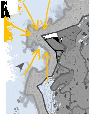
Figure n°169: Wind Data (Source Author) The strong winds characterizing the coastal slope of Ain Kanassira are essentially due to the exposure of its coasts to NW to SW directions as well as its opening on a relatively open sea. In fact, the most frequent winds come from the SW to NW sector, with a strong predominance of the west winds. In contrast, the strongest winds (around 20 m/s) come from the W to NW sector (MEHAT, 2016). These winds cause the longest and strongest agitation and are also responsible for the considerable wave heights that, through their hydrodynamic actions, contribute to the Hydrodynamic scouring* of the toe of the slope.
The locals call the North wind ''Bhari" ( ) : is a يراحب wind that blows southward and has its source in the north. In the Northern Hemisphere, it frequently denotes cold weather and a shift in seasons.
Conserving Ain Kanassira’s Resources Page
II. 2.a
D/ Clouds :
The average percentage of the sky covered by clouds varies significantly seasonally throughout the year. Ain Kanassira's clearer season begins about June 14 and lasts for 2.9 months, finishing around September 9. July is the clearest month of the year in with the sky clear, mostly clear.
The cloudier season starts about September 9 and lasts 9.1 months, ending around June 14. October is the cloudiest month of the year, with the sky overcast or mostly cloudy 41% of the time.


Figure n°171: Cloud Cover Categories in Ain Kanassira (Source weatherspark.com )


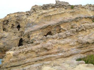
E / Lithology* :
The sedimentary series of Jbel Korbous is constituted by the Fortuna formation dating from the Oligocene-Miocene ( The Oligocene is a geologic epoch of the Paleogene Period and extends from about 33.9 million to 23 million years before the present ) It is formed by the succession of marls and sandstones at the base, followed by sands and surmounted by coarse sandstones. At the base we can meet clays with intercalation of sand and nummulitic calcareous sandstones.
Conserving Ain Kanassira’s Resources

II. 2.a
Marls Coarse Sandstones Sandstones Nummulitic calcareous sandstones

sandstone limestone and marl Clays and fine sandstones Coarse Sandstone

Figure n°172: Map of the distribution of lithologic outcrops (Source geoecotrop.be)

Figure n°173: Clay (Source Author) Sometimes we can find places where the clay content is high, which makes a perfect composition for extraction for pottery making.
F/ Natural Phenomena :
Rockslides are designated as a sudden fall of a rock mass of several tens of m3 which detaches itself from a surface or a very steep slope. At the moment of the fall, the rock mass breaks up into a multitude of blocks and piles up as a chaotic accumulation at the foot of the slope. Here, the mechanisms responsible for the detachment of the rocks and their collapse are closely related to the tectonic, topographic, and climatic characteristics of the region.
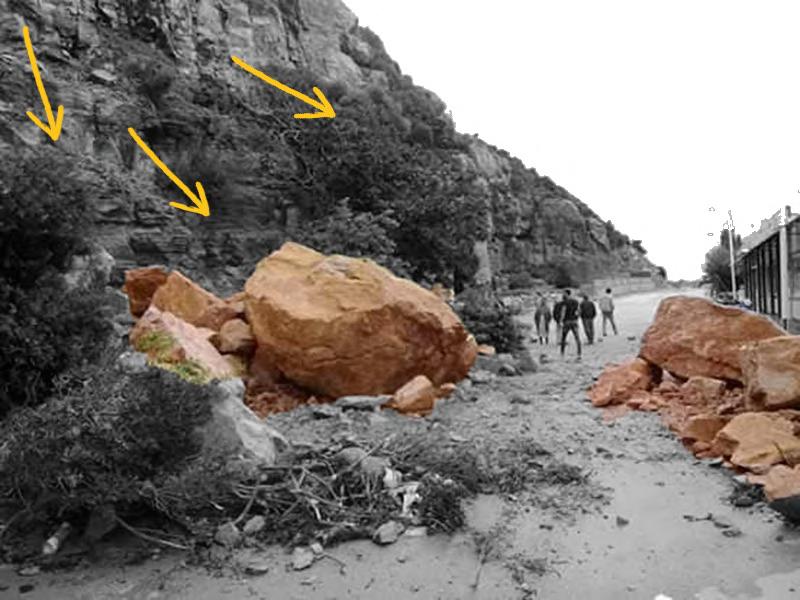
Figure n°174: Rockslide (Source Author)
Conserving Ain Kanassira’s Resources
II. 2.a
The detachment which will take place near the rock faces is facilitated by the nature of the lithological formations which, crossed by a dense network of joints (a break), flow rather easily and allow the release of numerous blocks, sometimes of great size.
Alternation of sandstone and clay Rockslide Cliff cracking Retaining wall

These joints facilitate the circulation of water and favor the imbibition and humidification of the underlying clayey levels. Once the threshold of plasticity is reached, the sandstone benches, already fractured, tilt and, subsequently, collapse on the slope.
Figure n°175: Schematic representation of Rocksliding (Source geoecotrop.be)
Built with carved natural stones
Identified Material on site
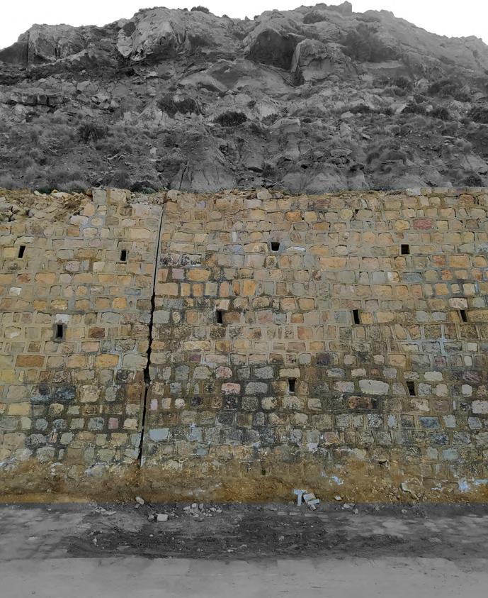
Figure n°176: Retaining wall (Source Author)
Clay Pebble Stone Marls Sandstone

The objective is an architecture that is more respectful of the living world, that enhances the ecological materials already existing on the site, and that favors solutions that do not harm it. And as mentioned in chap1 , the ecopsychology, by preserving and protecting nature we help to enhance our well being and psyche.


