Akureyri, the “capital of the sunny north,” is Iceland’s largest municipality outside the capital area.
There are thousands of islands, islets and skerries in Breiðafjörður Bay. The only inhabited island in the bay, and the biggest, is Flatey (meaning “flat island”). The area around Hvammstangi is one of the best seal-watching areas in Iceland.
A RARE,ONCEIN-A-LIFETIME OPPORTUNITY
passionate about ICeland EastWest provides exceptional small group tours and private tours in a prime fleet of Mercedes-Benz Sprinters with USB connectors and onboard WIFI.
FREE
COPY
Herðubreið is often called the “Queen of Icelandic Mountains” and was voted Iceland’s “national mountain” in 2002.
According to some, Hveravellir boasts “the best nature hot tube” in Iceland.
Daily departures from Húsafell and Reykjavík to the World´s largest ice tunnel on Langjökull glacier.
green ban In the vi a tuff Dimmubor Hverarön
The area around the stratovolcano Askja is where NASA astronauts trained for the first moonlanding.
Book your tour online, www.intotheglacier.is Tel: +354 578-2550
A RARE,ONCEIN-A-LIFETIME OPPORTUNITY
www.eastwest.is
Daily departures from Húsafell and Reykjavík to the World´s largest ice tunnel on Langjökull glacier.
Book your tour online, www.intotheglacier.is Tel: +354 578-2550
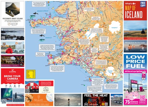
Sub-glacial stratovolcano Snæfellsjökull is the entrance to a passage leading to the centre of the Earth, according to Jules Verne’s novel Journey to the Centre of the Earth (1864).
Reykholt was the home of legendary Icelandic historian, poet, and politician Snorri Sturluson (1179-1241). He was the author of the Prose Edda and Heimskringla.
The highest rated hot spring in Iceland 45 minutes from Reykjavik
REVIEWS
The Geysir geothermal area and the nearby waterfall Gullfoss rank among Iceland’s most popular tourist attractions.
Þingvellir National Park is where Alþingi, the Icelandic parliament, was founded in 930 AD. The park lies in a rift valley that marks the boundary between two tectonic plates. According to the Icelandic Book of Settlements, Reykjavík was home to Iceland’s first permanent settlers: the Viking couple Ingólfur Arnarson and Hallveig Fróðadóttir, who settled in 874 AD. Two out of three Icelanders reside in the capital area.
+354 591 2880 syning@or.is
Skálholt
96% of those who visit Iceland pass through Keflavík International Airport.
Vatnajökull, Europe’s large glacier, covers 8% of Icelan
The volcanic crater lake Kerið was formed approximately 3,000 years ago.
To order more free copies contact What’s On, Tourist Information, Laugavegur 5, 101 Reykjavík • +354-551-3600 • map@whatson.is • www.whatson.is
Minutes from the City Centre The volcanic fissure Laki erupted between 1783-1786, creating one of the largest lava flows in human history.
Hekla is Iceland’s most famous (and most active) volcano. During the Middle Ages, Europeans referred to Hekla as the “Gateway to Hell.” Secure your Spot
Don’t Fight the Power. Feel It.
LOW PRICE
Open every day from 9am-5pm. exhibition@on.is Tel: (+354) 591 2880 www.onpower.is/exhibition
Glacier Walks
& Outdoor Adventures
A journey into RAUFARHÓLSHELLIR
Breathtaking Experience
For more information and bookings: +354 519 1616
www.thelavatunnel.is
+354 760 1000 info@thelavatunnel.is
BRING YOUR CAMERA WHALE WATCHING WITH THE PROS FROM REYKJAVÍK & AKUREYRI
NORTHERN LIGHTS TOURS
IMAGINE PEACE TOWER
Þingvellir Kirkjufell Geysir Gullfoss Skógafoss Reynisfjara Skaftafell Glacier Lagoon
with Orkan card to your Apple/Google wallet
45 km 178 km 107 km 113 km 153 km 185 km 322 km 377 km
The volcano Katla, underneath the Mýrdalsjökull icecap, last erupted in 1918. Scientists belive another eruption may be imminent. The Eyjafjallajökull volcano erupted in 2010, leaving hundred of thousands of air passengers stranded on both sides of the Atlantic (many a news anchor struggled to pronounce the volcano’s name).
Welcome to our family owned local store in the heart of south-Iceland.
VIÐEY ISLAND
Half the town on Heimaey in the Vestmannaeyjar archipelago was covered by lava in the famous Eldfell eruption in 1973. The community was rebuilt and now boasts one of the largest fishing harbours in Iceland.
Austurvegi 4 - 860 Hvolsvöllur
Dyrhólaey, the southernmost tip of the Icelandic mainland, is surrounded by distinct black beaches. Dyrhólaey was formerly known by seamen as Cape Portland.
YOUR JOURNEY OUR EXPERTISE
SCAN THE CODE TO FIND MORE INFORMATION
ELDING.IS
+354 519 5000
BOOK YOUR ESCAPE WWW.GJTRAVEL.IS GJTRAVEL@GJTRAVEL.IS
the Capit in
28
region al
The Golden Circle’s newest attraction
BOOK NOW
TEL: +354 587 9999
FUEL
The village of Grindavík was greatly affected by the recent volcanic activity on the Reykjanes peninsula. After having been locked down for some time it has recently been opened again for inhabitants and visitors as well.
Distances from Reykjavík
WHALE WATCHING
MOUNTAINGUIDES.IS •
Landmannalaugar lies at the northern end of the Laugavegur hiking trail and is known for its geothermal hot springs and surrounding landscape.
Stations
is a
75
QR code to get stations Scan your Orkan card or
around Iceland
visit orkan.is/english
EY JA FJÖ R Ð U R
Akureyri
Víkurskarð
28k
Pre-book online at earthlagoon.is
Akureyri
Tunnel
Seyðisfjörður
8k
Reykjavík
Pay toll within 24 hours at
www.tunnel.is Join us northsailing.is
www.geosea.is - @geoseaiceland - Vitaslóð 1, 640 Húsavík
forestlagoon.is
A number of old timber houses are to be found in Neðstikaupstaður, Ísafjörður’s harbour district, the oldest of which being Krambúðin (built in 1757).
LÖÐUR CAR WASH LODUR.IS/ENGLISH
Siglufjörður, the former “herring capital of Iceland,” is known for its award-winning Herring Era Museum, the largest maritime museum in Iceland.
The now uninhabited region of Hornstrandir is a summer hiking paradise.
Árneshreppur in the Strandir region is the smallest municipality in Iceland, inhabited by 30 people and thousands of sheep.
The waterfall Dynjandi is one of the most picturesque waterfalls in Iceland.
Hrafnseyri is the birthplace of Jón Sigurðsson (1811-1879), the leader of the 19th century Icelandic independence movement.
VISIT ICELAND’S LARGEST ICE TUNNEL
Svarfaðardalur on Tröllaskagi boasts one of the best backcountry skiing areas in Iceland.
Grímsey, the northernmost inhabited island in Iceland, is a bird paradise.
Húsavík is the “whale watching capital” of Iceland.
There are beautiful basalt columns on the Kálfhamarsvík cove.
Vopnafjörður has some of the best salmon rivers in the country. It is also home to one of Iceland’s most distinct turf farms, Bustarfell (it was inhabited until 1966).
The Dettifoss waterfall is reputed to be the second most powerful waterfall in Europe (after the Rhine Falls in Switzerland).
Bjargtangar is the westernmost point of Europe (excluding the Azores). Nearby is the 14 km (9 mile) long Látrabjarg sea cliff, which is home to millions of birds, and is the largest bird cliff in Europe.
A RARE,ONCEIN-A-LIFETIME OPPORTUNITY Daily departures from Húsafell and Reykjavík to the World´s largest ice tunnel on Langjökull glacier.
Seyðisfjörður, known for its bustling art scene, is where the international ferry Norræna, connecting Iceland to the Faroe Islands and Europe, docks.
Vegagerðin Icelandic Road and Coastal Administration, IRCA
Herðubreið is often called the “Queen of Icelandic Mountains” and was voted Iceland’s “national mountain” in 2002.
According to some, Hveravellir boasts “the best nature hot tube” in Iceland.
Hafrahvammagljúfur is a magnificent canyon carved out by a glacial river
Neskaupstaður is the easternmost town of Iceland.
The area around the stratovolcano Askja is where NASA astronauts trained for the first moonlanding.
Book your tour online, www.intotheglacier.is Tel: +354 578-2550
Stöðvarfjörður is famous for Petra’s Stone Collection (she also collected marked pens, cups, eggs, shells, and conches).
A RARE,ONCEIN-A-LIFETIME OPPORTUNITY Daily departures from Húsafell and Reykjavík to the World´s largest ice tunnel on Langjökull glacier.
Distances from Reykjavík
LUGGAGE STORAGE SAFE & CONVENIENT
TOURIST INFORMATION & BOOKING CENTER
Laugavegur 5 •101 Reykjavík
Selfoss Vík Höfn Egilsstaðir Húsavík Mývatn Akureyri Ísafjörður Stykkishólmur
55 km 184 km 456 km 628 km 463 km 482 km 380 km 406 km 170 km
Book your tour online, www.intotheglacier.is Tel: +354 578-2550
Sub-glacial stratovolcano Snæfellsjökull is the entrance to a passage leading to the centre of the Earth, according to Jules Verne’s novel Journey to the Centre of the Earth (1864).
Reykholt was the home of legendary Icelandic historian, poet, and politician Snorri Sturluson (1179-1241). He was the author of the Prose Edda and Heimskringla.
The Geysir geothermal area and the nearby waterfall Gullfoss rank among Iceland’s most popular tourist attractions.
Þingvellir National Park is where Alþingi, the Icelandic parliament, was founded in 930 AD. The park lies in a rift valley that marks the boundary between two tectonic plates. According to the Icelandic Book of Settlements, Reykjavík was home to Iceland’s first permanent settlers: the Viking couple Ingólfur Arnarson and Hallveig Fróðadóttir, who settled in 874 AD. Two out of three Icelanders reside in the capital area. Skálholt
96% of those who visit Iceland pass through Keflavík International Airport.
Borgarfjörður Eystri is the “puffin capital” of Iceland.
Mývatn is characterized by its green banks and rich birdlife. In the vicinity are Hverfjall, a tuff ring volcano; the Dimmuborgir lava field; and the Hverarönd geothermal area.
Akureyri, the “capital of the sunny north,” is Iceland’s largest municipality outside the capital area.
The area around Hvammstangi is one of the best seal-watching areas in Iceland.
Visit trafficinfo.is or call 1777
Bakkafjörður is one of Iceland’s smallest villages and the one that lies the farthest away from Reykjavík.
According to legend, the glacial canyon Ásbyrgi was formed when the hoof of Óðinn’s (the Norse God) eight-legged horse Sleipnir touched down from the heavens.
There are thousands of islands, islets and skerries in Breiðafjörður Bay. The only inhabited island in the bay, and the biggest, is Flatey (meaning “flat island”).
Road conditions
The Langanes peninsula is a good place for watching gannets (seabirds) up close.
The volcanic crater lake Kerið was formed approximately 3,000 years ago.
Hekla is Iceland’s most famous (and most active) volcano. During the Middle Ages, Europeans referred to Hekla as the “Gateway to Hell.”
Vatnajökull, Europe’s largest glacier, covers 8% of Iceland.
The Kverkfjöll mountain range, which lies partly underneath the Vatnajökull icecap, is one of the few places on Earth where one can witness hot springs in a glacier.
At 1,069 metres (3,507 ft.) Búlandstindur’s pyramidal shape makes it one of the most shapely mountains in Iceland. It’s a great place for spotting reindeer.
The volcanic fissure Laki erupted between 1783-1786, creating one of the largest lava flows in human history. Höfn in Hornafjörður, with its beautiful harbour, is known as the “lobster capital” of Iceland.
Don’t Fight the Power. Feel It.
Pay toll within 24 hours at
LEGEND
Icebergs from Vatnajökull calve into the unique glacier lagoon Jökulsárlón, the scene of many Hollywood movies.
Open every day from 9am-5pm. exhibition@on.is Tel: (+354) 591 2880 www.onpower.is/exhibition
Glacier Walks
& Outdoor Adventures
www.spolur.is Ho
MUSEUM
PLACE HIKING OF PATHS INTEREST
FERRY
PAY TOLL
Roundabout
Hornafjörður Höfn
The village of Grindavík was greatly affected by the recent volcanic activity on the Reykjanes peninsula. After having been locked down for some time it has recently been opened again for inhabitants and visitors as well.
Spölur SECONDARY OFF-ROAD ROAD TRACK
MAIN ROAD
ROAD NUMBER
The volcano Katla, underneath the Mýrdalsjökull icecap, last erupted in 1918. Scientists belive another eruption may be imminent. The Eyjafjallajökull volcano erupted in 2010, leaving hundred of thousands of air passengers stranded on both sides of the Atlantic (many a news anchor struggled to pronounce the volcano’s name). Half the town on Heimaey in the Vestmannaeyjar archipelago was covered by lava in the famous Eldfell eruption in 1973. The community was rebuilt and now boasts one of the largest fishing harbours in Iceland.
To order this map & for questions & comments email: info@whatson.is
Dyrhólaey, the southernmost tip of the Icelandic mainland, is surrounded by distinct black beaches. Dyrhólaey was formerly known by seamen as Cape Portland.
Visit the World’s Only Beluga Whale and Puffin Sanctuary!
FONTANA.IS
jó t
At 2,110 metres (6,921 ft.), Hvannadalshnjúkur is Iceland’s highest peak.
a rfl
TEL: +354 587 9999
fj a rð
MOUNTAINGUIDES.IS •
rn a
Landmannalaugar lies at the northern end of the Laugavegur hiking trail and is known for its geothermal hot springs and surrounding landscape.
Book & e Onlinve! Sa
belugasanctuary.sealifetrust.org
TOURIST INFORMATION IN REYKJAVÍK What’s On (Open from 8:30 to 21:00 every day) Laugavegur 5 What’s On (Open from 11:00 every day)
Laugavegur 54
Stop staring at the map.
Book your adventure!
NATIONAL PARK
COUNTRY PARK
OFF-ROAD VEHICLES ONLY
LIGHTHOUSE
NATURE NATIONAL RESERVE MONUMENT
Although every effort has been made to ensure that the information published on this map is accurate, it should not be followed blindly. What’s On accepts no liability rising from reliance upon the information. CAUTION This small-scale map is suitable for travel planning. For greater accuracy, large-scale maps should be used. A variety of detailed and reliable maps from the National Land Survey of Iceland are available in book stores, tourist information centres and filling stations around Iceland.
VOLCANO & EARTHQUAKE EXHIBITION Best I have ever experienced! – Tripadvisor
ORKAN CHARGING
ORKAN GAS STATION
63.753 1° N, 20.236 4° W
First stop on the south coast of Iceland
lavacenter.is
TRAVEL EASY, ADVENTURE BIG