2 minute read
Boone at a Glance
FILE PHOTO Appalachian Rhythm performs during the Boone St. Patrick’s Day Parade on March 16, 2019. The dance and clogging troupe won the award for Best in Show.
BOONE AT A GLANCE BY ANNA OAKES
It’s small-town living in a safe, tight-knit community. It’s the county seat of Watauga County and the High Country’s regional economic center. It’s the home of Appalachian State University. It’s a nationally recognized outdoor recreation destination, and on top of that, it’s the headquarters for top-notch education and health care systems.
make Boone the best place to live!
The town of Boone was incorporated in 1872, acquiring its name from the famous pioneer and explorer Daniel Boone, who hunted and camped in the area.
Boone has the highest elevation (3,300 feet) of any town of its size (greater than 10,000 population) east of the Mississippi River. The altitude contributes to mild summer
All of these reasons and more
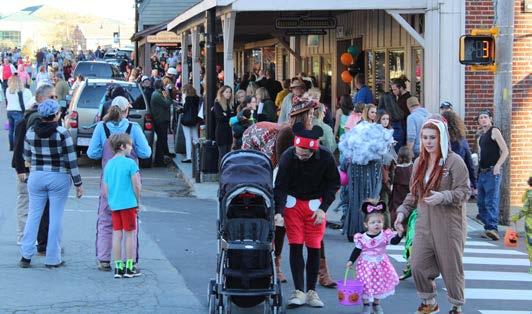
FILE PHOTO Visitors pack downtown Boone for the annual Boone BOO!
weather — an escape from the heat and humidity of the greater South — and snowfalls create winter wonderlands.
Travelers access Boone via U.S. 421, U.S. 321 and U.S. 221, which provide access to Interstates 40, 77, 85, 81 and 26. The Blue Ridge Parkway — a scenic mountain road and national park that traverses 469 miles in North Carolina and Virginia — also passes through the county.
Multiple neighborhoods are within walking distance of downtown Boone, which offers a vibrant mix of college town culture, mountain heritage and
SEE GLANCE ON PAGE 16
BY THE
NUMBERS:
BOONE AND
WATAUGA
COUNTY
Sources: The following information is compiled from the U.S. Census Bureau, the NOAA, Watauga County and the N.C. Department of Commerce.
POPULATION
• Population, 2019 estimate: Boone, 19,667; Watauga County,
56,177
• Percent population estimate change from April 1, 2010, to July 1, 2019: Boone, 14.9 percent; Watauga County, 10 percent
GEOGRAPHY
• Land area in square miles, 2010: Boone: 6.13; Watauga County,
312.56
• Persons per square mile, 2010: Boone, 2,792.7; Watauga, 163.4
CLIMATE
• Average maximum temperature, July (1981-2010): 78.9 °F • Average minimum temperature, January (1981-2010): 20.7 °F • Normal annual precipitation (1981-2010): 52.66 inches • Normal annual snowfall (19812010): 35.3 inches
EDUCATION
• Percent of persons 25 and older with a high school diploma or higher, 2018: Boone, 87.3 percent; Watauga, 89.5 percent • Percent of persons 25 and older with a bachelor’s degree or higher, 2018: Boone, 47.1 percent; Watauga, 41.6 percent
INCOME (WATAUGA COUNTY)
• Median household income, 2018:
$45,268
• Percent of persons below poverty level: 21.1 percent*
A 2013 report from the U.S. Census Bureau found that the presence of off-campus college students can skew a community’s poverty rates higher
OTHER
• Property tax rate (per $100 valuation): Boone, $0.41; Watauga,
$0.403
• Unemployment rate, Watauga County, July 2020: 6.6 percent • Average travel time to work, 2018: Boone, 13.5 minutes; Watauga, 20.2 minutes


