ISBN: 9781319322239
Chapter 01
1. Geography is the study of Earth's __________.
a. weather systems
b. crust
c. life
d. physical, biological, and cultural systems and how they change through space and time
ANSWER: d
2. Physical geography is mainly concerned with __________.
a. the state of the atmosphere at any given moment
b. the study of Earth's living and nonliving physical systems
c. the rigid outer crust of Earth
d. the water in the oceans and in the atmosphere
ANSWER: b
3. Which question would you least likely explore in Living Physical Geography?
a. Why is there winter and summer?
b. Why do mountains form and how are they worn down?
c. Why are there no polar bears in the Southern Hemisphere or penguins in the Northern Hemisphere?
d. What is the population of India?
ANSWER: d
4. A system is a __________.
a. set of interacting parts that function as a unit
b. theory that helps scientists understand Earth
c. group of ideas
d. way of mapping Earth's surface
ANSWER: a
5. Which is an example of an anthropogenic phenomenon?
a. Earth's climate system
b. ocean currents
c. croplands
d. tropical rainforest
ANSWER: c
6. Which one of the following would be the best scale to study the coastline of the Namib Desert in Africa?
a. temporal
b. local
c. regional
d. global
ANSWER: c
7. People depend on Earth's physical systems because they __________.
a. provide resources for people
b. are part of Earth's physical geography
c. occupy space and possess mass
d. allow us to better understand Earth
ANSWER: a
8. Which is an example of a spatial phenomenon?
a. the age of a mountain range
b. the temperature of an ocean
c. the size of a thunderstorm
d. the strength of a hurricane
ANSWER: c
9. Which is an example of a temporal phenomenon?
a. the age of a mountain range.
b. the temperature of an ocean
c. the size of a thunderstorm
d. the strength of a hurricane
ANSWER: a
10. Which is the smallest spatial scale?
a. a view of Earth
b. a view of a mountain
c. a view of a lake
d. a view of a tree
ANSWER: a
11. Which has the longest temporal scale?
a. an earthquake
b. El Niño
c. forest migration
d. mountain building
ANSWER: d
12. Energy is __________.
a. the capacity to change and do work on physical matter
b. a form of activity
c. not very important to physical geography
d. an example of climate change
Name: Class:
Chapter 01
ANSWER: a
13. Matter occurs in state(s).
a. one
b. two
c. three
d. four
ANSWER: c
14. Geothermal energy is energy from __________.
a. the Sun
b. living organisms
c. the atmosphere
d. Earth's interior
ANSWER: d
15. An example of radiant energy is energy from __________.
a. the Sun
b. living organisms
c. the atmosphere
d. Earth's interior
ANSWER: a
16. Photosynthesis is the process in which plants, algae, and bacteria __________.
a. convert solar radiant energy to chemical energy
b. convert thermal energy to radiant energy
c. are created
d. grow
ANSWER: a
17. Which is an example of potential energy?
a. a boulder perched on a cliff
b. a falling boulder
c. electricity
d. heat
ANSWER: a
18. Which is an example of kinetic energy?
a. a boulder perched on a cliff
b. a falling boulder
c. a taut bowstring
Name: Class:
Chapter 01
d. a reservoir behind a dam
ANSWER: b
19. What form of energy is water sitting in a reservoir that will be released to make electricity?
a. kinetic
b. chemical
c. electrical
d. potential
ANSWER: d
20. The energy to build Earth's surface relief comes from __________.
a. the Sun
b. Earth's interior
c. the rocks
d. organisms
ANSWER: b
21. The includes the crust and the heated layer below it.
a. atmosphere
b. biosphere
c. lithosphere
d. hydrosphere
ANSWER: c
22. The is the layer of gases that surrounds Earth.
a. atmosphere
b. biosphere
c. lithosphere
d. hydrosphere
ANSWER: a
23. Which is not a part of the hydrosphere?
a. a glacier
b. a river
c. a plant
d. a cloud
ANSWER: c
24. The oceans cover percent of the planet's surface.
a. 56
b. 67
01
c. 71
d. 85
ANSWER: c
25. The oceans are kilometers deep on average.
a. 4
b. 5
c. 6
d. 7
ANSWER: a
26. The is all life on Earth.
a. atmosphere
b. biosphere
c. lithosphere
d. hydrosphere
ANSWER: b
27. The includes all water on Earth.
a. atmosphere
b. biosphere
c. lithosphere
d. hydrosphere
ANSWER: d
28. The lithosphere extends down to about kilometers.
a. 10
b. 100
c. 200
d. 500
ANSWER: b
29. The crust is broken into large plates.
a. 8
b. 10
c. 12
d. 14
ANSWER: d
30. Which is an example of climate?
a. the average temperature of a region
Name: Class:
b. a single day of extreme heat
c. a single day of heavy precipitation
d. a large tornado
ANSWER: a
31. Geothermal energy drives __________.
a. the biosphere
b. plate tectonics
c. precipitation
d. climate
ANSWER: b
32. Erosion is the process of rock fragments.
a. transporting
b. depositing
c. making
d. cementing together
ANSWER: a
33. Which system is not solar powered?
a. the atmosphere
b. the biosphere
c. building up of the lithosphere
d. erosion of the lithosphere
ANSWER: c
34. Which is not an agent of erosion?
a. streams
b. glaciers
c. chemical reactions
d. wind
ANSWER: c
35. Ultimately, the energy that drives erosion comes from __________.
a. Earth's internal heat
b. organisms
c. the wind
d. the Sun
ANSWER: d
36. The frequent recurrence of carbon-dioxide releasing wildfires due to increased global temperatures caused
Name: Class:
Chapter 01
by fossil fuel combustion that increases atmospheric carbon dioxide is an example of a __________.
a. positive feedback
b. warming trend
c. negative feedback
d. climate feedback
ANSWER: a
37. Referring to the figure, which statement describes how the Sun provides energy to power this electric vehicle?
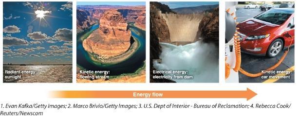
a. Radiant energy is converted to kinetic energy, which is converted to electrical energy that powers the car.
b. Kinetic energy is converted to radiant energy that powers the car.
c. Electrical energy is converted to kinetic energy that powers the car.
d. Electrical energy is converted to radiant energy, which is converted to kinetic energy that powers the car.
ANSWER: a
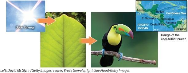
38. Which statement describes the transformation of energy shown in this figure?
a. Radiant energy is converted to chemical energy that fuels the biosphere.
b. Geothermal energy is converted to kinetic energy that fuels the biosphere.
c. Radiant energy is converted to kinetic energy that fuels the biosphere.
d. Kinetic energy is converted to radiant energy that fuels the biosphere.
ANSWER: a
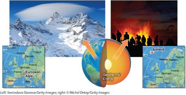
39. Which statement describes the transformation of energy shown in this figure?
a. Geothermal energy is converted to chemical energy that builds the lithosphere.
b. Geothermal energy is converted to kinetic energy that builds the lithosphere.
c. Radiant energy is converted to kinetic energy that builds the lithosphere.
d. Kinetic energy is converted to geothermal energy that builds the lithosphere.
ANSWER: b
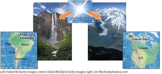
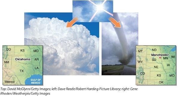
40. Which statement describes the transformation of energy shown in this figure?
a. Radiant energy is converted to chemical energy that erodes the lithosphere.
b. Geothermal energy is converted to kinetic energy that erodes the lithosphere.
c. Radiant energy is converted to kinetic energy that erodes the lithosphere.
d. Kinetic energy is converted to radiant energy that erodes the lithosphere.
ANSWER: c
41. Which statement describes the transformation of energy shown in this figure?
a. Radiant energy is converted to chemical energy that erodes the lithosphere.
b. Geothermal energy is converted to kinetic energy that erodes the lithosphere.
c. Radiant energy is converted to kinetic energy that erodes the lithosphere.
d. Kinetic energy is converted to radiant energy that erodes the lithosphere.
ANSWER: c
42. The is a coordinate system used to identify locations on Earth's surface.
a. equator
b. prime meridian
c. geographic grid
d. Global Positioning System
ANSWER: c
43. The divides Earth into two equal halves.
a. equator
b. prime meridian
c. North Pole
d. South Pole
ANSWER: a
44. The is located at 90 degrees north latitude.
a. North Pole
b. South Pole
c. equator
d. prime meridian
ANSWER: a
45. The is at 0 degrees longitude.
a. equator
b. prime meridian
c. North Pole
d. South Pole
ANSWER: b
46. On the equator, meridians are kilometers apart.
a. 0
b. 53
c. 111
d. 200
ANSWER: c
47. At the South Pole, meridians are kilometers apart.
a. 0
b. 53
c. 111
d. 200
ANSWER: a
Chapter 01
48. The are found between 23.5 degrees north and south.
a. tropics
b. midlatitudes
c. high latitudes
d. polar regions
ANSWER: a
49. The are found between 80 and 90 degrees north and south.
a. tropics
b. midlatitudes
c. high latitudes
d. polar regions
ANSWER: d
50. The are found between 35 and 55 degrees north and south.
a. tropics
b. midlatitudes
c. high latitudes
d. polar regions
ANSWER: b
51. The are found between 23.5 degrees and 35 degrees north and south.
a. tropics
b. subtropics
c. midlatitudes
d. high latitudes
ANSWER: b
52. uses satellites to identify the locations on Earth.
a. The geographic grid
b. The Global Positioning System
c. Doppler radar
d. Sonar
ANSWER: b
53. Which U.S. state is farthest east on the geographic grid?
a. Alaska
b. Maine
c. Vermont
d. Hawaii
Name: Class:
Chapter 01
ANSWER: a
54. A is the shortest distance between two points on the globe.
a. meridian
b. parallel
c. small circle route
d. great circle route ANSWER: d
55. Which of these is a great circle?
a. the equator
b. the prime meridian
c. the 55th parallel
d. the 170th meridian
ANSWER: a
56. The 0 degree meridian is also called the __________.
a. equator
b. prime meridian
c. 55th parallel
d. 170th meridian
ANSWER: b
57. How many degrees of latitude separate the equator from the North Pole?
a. 0
b. 45
c. 90
d. 180
ANSWER: c
58. Longitudes run as high as degrees.
a. 0
b. 45
c. 90
d. 180
ANSWER: d
59. Which location cannot exist?
a. 1 degree south, 1 degree west
b. 70 degrees north, 0 degrees east
c. 140 degrees south, 10 degrees west
Chapter 01
d. 10 degrees north, 123 degrees east
ANSWER: c
60. An equal-area map projection
a. preserves the true areas of continents at the expense of their true shapes.
b. preserves both true shapes and true areas of continents.
c. preserves the true shapes of continents at the expense of their true areas.
d. preserves neither true shapes or true areas of continents.
ANSWER: a
61. A conformal map projection
a. preserves the true areas of continents at the expense of their true shapes.
b. preserves both true shapes and true areas of continents.
c. preserves the true shapes of continents at the expense of their true areas.
d. preserves neither true shapes or true areas of continents.
ANSWER: c
62. Which of the following would be the best map projection to use in order to compare the true size of Alaska compared to Texas?
a. cylindrical projection
b. a conformal projection
c. an equal-area projection
d. orthographic projection
ANSWER: c
63. Which type of projection creates a tangent that may run the length of the equator?
a. cylindrical projection
b. conic projection
c. azimuthal projection
d. orthographic projection
ANSWER: a
64. Which type of projection creates a tangent that forms a single point?
a. cylindrical projection
b. conic projection
c. azimuthal projection
d. orthographic projection
ANSWER: c
65. Which type of projection creates a tangent that traces the path of a small circle?
a. cylindrical projection
Name: Class:
b. conic projection
c. azimuthal projection
d. orthographic projection
ANSWER: b
66. The distance an object is submerged below the surface of the ocean is referred to as a. elevation.
b. altitude.
c. depth.
d. topography.
ANSWER: c
67. The height of an airplane flying above sea level is referred to as a. elevation.
b. altitude.
c. depth.
d. topography.
ANSWER: b
68. The height of a car driving in the mountains above sea level is referred to as a. elevation.
b. altitude.
c. depth.
d. topography.
ANSWER: a
69. The relative difference in elevation between two or more points on Earth's surface is called a. elevation.
b. altitude.
c. relief.
d. topography.
ANSWER: c
70. Isolines never ________.
a. cross each other
b. represent the same value
c. repeat values
d. loop back
ANSWER: a
71. A(n) is a type of isoline that connects equal values of temperature.
Chapter 01 Copyright Macmillan Learning. Powered by Cognero.
Name: Class:
Chapter 01
a. isobar
b. contour line
c. isotherm
d. isohyet
ANSWER: c
72. Which map scale is still accurate after a map has been reduced or enlarged from its original size?
a. bar scale
b. verbal scale
c. representative fraction scale
d. map scale
ANSWER: a
73. "One centimeter equals 5 kilometers" is an example of what kind of map scale?
a. a bar scale
b. a verbal scale
c. a representative fraction scale
d. a measurement
ANSWER: b
74. Which is not among the elements maps generally should have?
a. border
b. title
c. map scale
d. legend
ANSWER: a
75. Topography is __________.
a. a geographic locating system
b. the height of the tallest object in a landscape
c. the shape and physical character of Earth's surface
d. a mapping technique
ANSWER: c
76. A contour line is used to show __________.
a. population
b. the biosphere
c. weather
d. topography
ANSWER: d
Chapter 01
77. If people continue to walk along a contour line, what will eventually happen?
a. They will experience a wide range of weather conditions.
b. They will encounter many forms of life.
c. They will climb uphill.
d. They will end up where they started.
ANSWER: d
78. Where contour lines are close together on a map, __________.
a. the slope is steep
b. the temperature is low
c. the population is high
d. the vegetation is changing
ANSWER: a
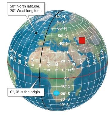
79. Which set of coordinates locates the red square on this figure?
a. 60° N, 40° E
b. 40° S, 60° E
c. 40° N, 60° E
d. 0°, 30° W
ANSWER: c
80. Which set of coordinates locates the blue circle on this figure?
a. 20° S, 20° E
b. 10° N, 30° E
c. 40° S, 20° E
d. 0°, 30° W
ANSWER: a
81. Which is not an example of remote sensing?
a. taking soil samples
b. Doppler radar
c. sonar
d. digital photography
ANSWER: a
82. Which technology can be used to map rainfall in a hurricane?
a. Doppler radar
b. LIDAR
c. sonar
d. lasers
ANSWER: a
83. What remote sensing technology is used to map the seafloor?
a. Doppler radar
b. LIDAR
c. sonar
d. lasers
ANSWER: c
84. A GIS is what?
a. a navigation instrument
b. a tropical storm system
c. a way to display and analyze spatial data
d. a map scale
ANSWER: c
85. Which order is a logical sequence of the scientific method?
a. observations, questions, hypothesis development, hypothesis testing, further inquiry
b. hypothesis testing, observations, questions, hypothesis development, further inquiry
c. further inquiry, hypothesis development, observations, questions, hypothesis testing
d. hypothesis development, observations, questions, hypothesis testing, further inquiry
ANSWER: a
Name: Class:
Chapter 01
86. Which European group was the first to find Rapa Nui?
a. the French
b. the Spanish
c. the Dutch
d. the Portuguese
ANSWER: c
87. The giant statues on Rapa Nui are called what?
a. ahu
b. moai
c. rapa nui
d. lapita
ANSWER: b
88. When geographers examined the history of Rapa Nui, what key evidence did they find that indicated that the island was once forested?
a. ancient pollen
b. ancient insect remains
c. ancient wood
d. ancient burial sites
ANSWER: a
89. The loss of Rapa Nui’s forests occurred mostly because of what?
a. fire
b. poor soils
c. rats
d. boat building
ANSWER: c
90. How might the rats brought to Rapa Nui by Polynesians have contributed to the demise of the people of living there?
a. The rats brought disease to the people.
b. The rats ate the seeds of trees and the birds that pollinated trees.
c. The rats ate most of the humans' food stores.
d. The people starved after the rat populations disappeared.
ANSWER: b
91. Humans have little effect on Earth's physical systems.
a. True
b. False
ANSWER: False
Name: Class: Date:
Chapter 01
92. The material goods we use, like cell phones, cars, and computers, are not connected to Earth's physical systems.
a. True
b. False
ANSWER: False
93. Science is fundamental to the study of physical geography.
a. True
b. False
ANSWER: True
94. Temporal scale refers to size, length, distance, or area of an object or process.
a. True
b. False
ANSWER: False
95. Physical geography emphasizes phenomena or processes occurring over scales of meters to the entire planet.
a. True
b. False
ANSWER: True
96. A photo sequence showing progressive deforestation illustrates both temporal and spatial scales.
a. True
b. False
ANSWER: True
97. The crust is the rigid outermost portion of Earth's surface.
a. True
b. False
ANSWER: True
98. The atmosphere consists mostly of nitrogen and carbon dioxide.
a. True
b. False
ANSWER: False
99. Water exists as a solid, a liquid, and a vapor.
a. True
b. False
ANSWER: True
100. When water evaporates, vapor turns to liquid.
Name: Class:
Chapter 01
a. True
b. False
ANSWER: False
101. Clouds are composed of water vapor.
a. True
b. False ANSWER: False
102. Living Physical Geography is structured around energy flows through Earth's physical systems.
a. True
b. False ANSWER: True
103. Most life on Earth obtains its energy from the Sun.
a. True
b. False
ANSWER: True
104. The energy for erosion is derived from Earth's heat.
a. True
b. False
ANSWER: False
105. A tornado's energy is derived from the Sun.
a. True
b. False ANSWER: True
106. An example of a positive feedback would be the following: Global warming → More water vapor in the atmosphere because the air is warmer → More warming (go back to start)
a. True
b. False ANSWER: True
107. Positive feedbacks stabilize physical systems.
a. True
b. False
ANSWER: False
108. The origin is found at 0 degrees latitude and 0 degrees longitude.
Name: Class:
Chapter 01
a. True
b. False
ANSWER: True
109. The equator is 0 degrees latitude.
a. True
b. False
ANSWER: True
110. The prime meridian is 180 degrees longitude.
a. True
b. False
ANSWER: False
111. Cartography is the art and science of map making.
a. True
b. False
ANSWER: True
112. Maps can portray spatial information and temporal information.
a. True
b. False
ANSWER: True
113. A map of a mountain has a relatively smaller map scale than a map of a continent.
a. True
b. False ANSWER: False
114. The highest point on Earth is Mount Everest at 8,848 meters (29,029 feet).
a. True
b. False ANSWER: True
115. The lowest point on Earth is Death Valley at –86 meters (–282 feet).
a. True
b. False
ANSWER: False
116. Contour lines are used on topographic maps to show changes in elevation.
a. True
b. False
Name: Class: Date:
Chapter 01
ANSWER: True
117. Radar is a form of passive remote sensing.
a. True
b. False
ANSWER: False
118. Doppler radar is an example of a remote sensing technology.
a. True
b. False
ANSWER: True
119. A digital elevation model is used to show topographic relief.
a. True
b. False
ANSWER: True
120. Digital elevation models can only be developed for surfaces above water.
a. True
b. False
ANSWER: False
121. A GIS is interactive and can be used to analyze spatial data.
a. True
b. False
ANSWER: True
122. A hypothesis is an idea that can be tested and proved incorrect.
a. True
b. False ANSWER: True
123. The process of science works by first having an idea, then collecting only those data that support the idea.
a. True
b. False
ANSWER: False
124. A theory is constructed from many hypotheses that have been tested and supported by scientific data and observations.
a. True
b. False
ANSWER: True
Chapter 01
125. If you walked along a parallel, which direction would you be walking?
ANSWER: You would be walking either east or west.
126. What are the basic elements of the scientific method?
ANSWER: The elements of the scientific method include observation, questioning, hypothesis development, data collection, hypothesis testing, and further inquiry.
127. The Rapa Nui said that the large statues “walked” to their present locations along the coast. Explain how this seemingly impossible notion could actually have a scientific basis.
ANSWER: Scientists attempted and succeeded in moving the statues by "walking" a replica statue with a system of ropes tied around the statue's head. Thus, the statues "walked" across the island.
128. What would happen to the biosphere if the Sun were to stop shining?
ANSWER: Almost all life on Earth would perish. Only bacteria and their ecosystems in deep-sea hydrothermal vents and hot springs would survive.
129. What would happen to the atmosphere if the Sun were to stop shining?
ANSWER: If the Sun were to stop shining there would be no solar energy. Solar energy evaporates water and creates wind. Without wind and water vapor, there would be no weather systems.
130. Give three examples of how Earth's physical systems affect one another.
ANSWER: Water evaporates from the hydrosphere to the atmosphere. Organisms in the biosphere put oxygen and carbon dioxide into the atmosphere. The lithosphere (volcanoes) puts carbon dioxide into the atmosphere. The oceans absorb carbon dioxide from the atmosphere.
131. If you were a forest manager and you were assigned the task of finding areas most in need of new tree plantings, what information and technology might be most useful to you?
ANSWER: A geographic information system (GIS) would be most useful. You would need different types of data that would indicate where trees may have been damaged and are in need of replanting. Spatial data on fire activity and bug infestations might be useful for determining where the forest is in need of new trees. Regions of drought might also be of interest. You might need spatial data on tree planting history for the area of interest, as well as temperature and precipitation data to help you decide which species of tree would be most suitable. You could put these layers of data in a GIS and analyze the data to identify areas most in need of plantings.
132. Explain the process by which people convert solar energy to electrical energy to run a computer by using a flowing stream.
ANSWER: The Sun's energy evaporates water. This water condenses and precipitates and flows downslope. People build dams to collect the runoff in a reservoir. A hydroelectric dam generates electricity from the water flowing out the base of the dam. The electricity powers the computer.
133. Explain the history of Rapa Nui from the perspective of our scientific understanding. What happened and why did it happen?
ANSWER: Rats ate the forest tree seeds, preventing the forests from regenerating. Without the forests, the islanders could not build boats (from logs). Nonetheless, the Rapa Nui lived sustainably on the island until first contact with Europeans. Europeans enslaved and brought Old World diseases to the
islanders, causing their populations to collapse.
134. "Insect outbreaks in western forests occur during warmer winters." Is this a testable hypothesis? If it is, what data would you need to test it?
ANSWER: This is a testable hypothesis. One could statistically compare insect population data with winter temperature data. If a correlation exists, the hypothesis is supported and can be accepted.