
Test Bank for Human Geography-A Spatial Perspective 1st Edition by Bednarz
ISBN: 9780357852002
Chapter 01 - The Power of Geography: Geographic Thinking
1. Which of the following is an example of absolute location?
a. At 36°S and 58°W
b. 14 miles south of Amsterdam
c. In the northeastern part of Brazil
d. On the banks of the Ganges River
e. At the intersection of Main Street and Poplar Avenue
ANSWER: a
2. Which of the following is an example of a relative location?
a. Down the street
b. 47.50° N, 19.04° E
c. Surrounded by mountains
d. Home to the Steelers
e. High on top of a mountain
ANSWER: a
3. Which term describes the number of people per a given unit of area (such as a square mile)?
a. Density
b. Distribution
c. Flow
d. Pattern
e. Situation
ANSWER: a
4. Human geography is best described as the study of which of the following?
a. The events and processes that have shaped how humans understand, use, and alter Earth
b. Natural processes and the distribution of features in the environment
c. Social relations in urban and rural communities
d. The ways humans and animals interact with each other beyond urban regions
e. The history of mapmakers
ANSWER: a
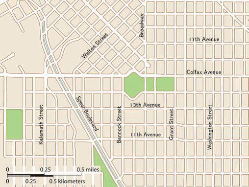
5. These maps of two different urban centers illustrate different urban:
Chapter 01 - The Power of Geography: Geographic Thinking
© Cengage Learning, Inc.
a. governments.
b. densities.
c. patterns.
d. sustainabilities.
e. cultures.
ANSWER: c
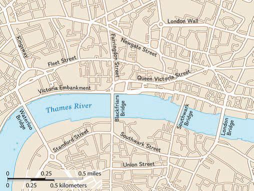
6. Which of the following geographic features has the greater impact on one of the city's patterns?
© Cengage Learning, Inc.
a. The Rocky Mountains
b. The European Union
c. The Thames River
d. The Colorado River
e. Denver’s many parks
ANSWER: c
7. Which of the following best explains the geographic principle of time-space compression?
Chapter 01 - The Power of Geography: Geographic Thinking
a. Places seem to all look alike.
b. Places seem like they are closer together.
c. Places are closer in space but not in time.
d. People in different places are making a greater effort to work together.
e. People in different places are more concerned about maintaining their traditions.
ANSWER: b
8. What is a primary argument against environmental determinism?
a. It undermines the principles of sustainability.
b. It ignores past civilizations in North Africa and Asia.
c. It underestimates the importance of genetic factors.
d. It emphasizes physical geography over human geography.
e. It overlooks the impact of new technologies in Europe and the Americas.
ANSWER: b
9. Which of the following geographic theories suggests that humans have an ability to affect their environment?
a. Humanism
b. Probability
c. Possibilism
d. World system theory
e. Environmental determinism
ANSWER: c
10. The term geographic scale refers to which of the following?
a. The area of the world being studied
b. The sense of distance as it relates to time
c. The ways in which people define regions
d. The ratio between distance on a map and distance on Earth’s surface
e. The economic interrelationship between core and peripheral countries
ANSWER: a
11. Which of the following scales of analysis would be most appropriate for examining migration patterns within a country?
a. Regional
b. Global
c. National
d. Local
e. State
ANSWER: c
12. Which of the following types of regions best describes the U.S. Midwest?
a. Nodal
b. Formal
c. Uniform
Chapter 01 - The Power of Geography: Geographic Thinking
d. Functional
e. Perceptual
ANSWER: e
13. What are latitude and longitude used to express?
a. Absolute location
b. Relative location
c. Site and situation
d. Population distribution
e. Demographic characteristics
ANSWER: a
14. Which factor or factors are included in the description of a place in relation to its surroundings?
a. Absolute location
b. Friction of distance
c. Site characteristics
d. Situational characteristics
e. Physical and human characteristics
ANSWER: d
15. Which term refers to how an issue changes with respect to whether it is looked at from a local or a global perspective?
a. Scale of analysis
b. Ecological perspective
c. World system theory
d. Distance decay model
e. Environmental determinism
ANSWER: a
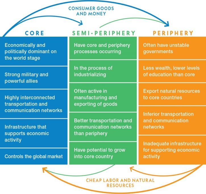
16. Which concept is shown in the graphic?
Chapter 01 - The Power of Geography: Geographic Thinking
© Cengage Learning, Inc.
a. Possibilism
b. The geo-inquiry process
c. Time-space compression
d. The distance decay model
e. World system theory ANSWER: e
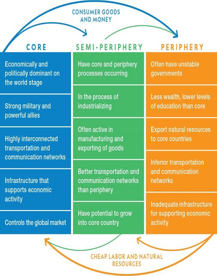
17. Based on the graphic, which of the following statements is true about the United States?
Chapter 01 - The Power of Geography: Geographic Thinking
© Cengage Learning, Inc.
a. The United States is a core country.
b. The United States is a peripheral country.
c. The United States is a semi-peripheral country.
d. The United States is both a core and a semi-peripheral country.
e. The United States is both a peripheral and a semi-peripheral country
ANSWER: a
18. The area served by the New York City subway system is an example of which type of region?
a. Formal region
b. Functional region
c. Perceptual region
d. Vernacular region
e. Agricultural region
ANSWER: b
19. Which term describes the expansion of economic, cultural, and political processes on a worldwide scale?
a. Capitalism
b. Globalization
c. Distance decay
d. Ecological perspective
e. Sustainable development
ANSWER: b
20. What determines a perceptual region’s boundaries?
a. A common language or culture
b. Local elected officials within a country
c. The opinions of one or more groups of people
d. Physical characteristics such as rivers or mountains
e. A downtown area or node and its surrounding area
ANSWER: c
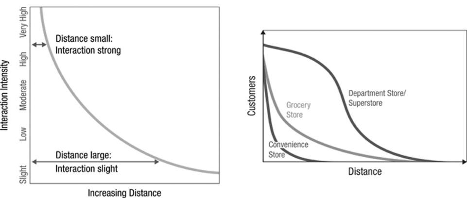
21. Which principle do these graphs convey?
© Cengage Learning, Inc.
Copyright Cengage Learning. Powered by Cognero.
Chapter 01 - The Power of Geography: Geographic Thinking
a. Distance decay
b. Relative distance
c. Absolute distance
d. Expansion diffusion
e. Environmental determinism
ANSWER: a
22. The theory of environmental determinism has fallen out of favor primarily because it did not take into account which of the following?
a. The impact of climate change
b. Indigenous cultures in the world today
c. The impact of climate and soil fertility
d. The impact of the Industrial Revolution
e. Ancient civilizations in North Africa and Asia
ANSWER: e
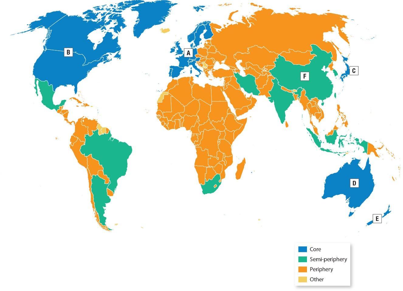
23. What geographic concept is illustrated by this map?
© Cengage Learning, Inc.
a. Globalization
b. Distance decay
c. World system theory
d. Sustainable development
e. Time-space compression
ANSWER: c
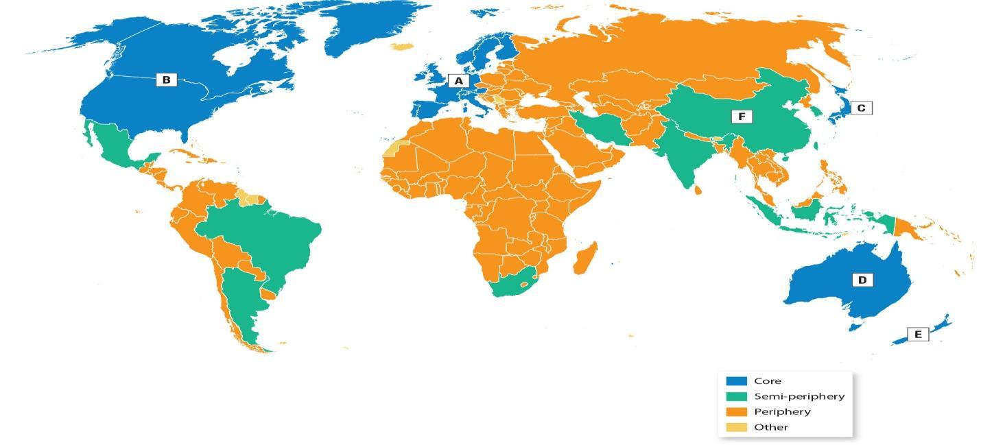
24. Into what category does Mexico fall?
Copyright Cengage Learning. Powered by Cognero.
Name:
Chapter 01 - The Power of Geography: Geographic Thinking
© Cengage Learning, Inc.
a. Core
b. Semi-periphery
c. Periphery
d. Other
e. Mexico is not shown on the map.
ANSWER: b
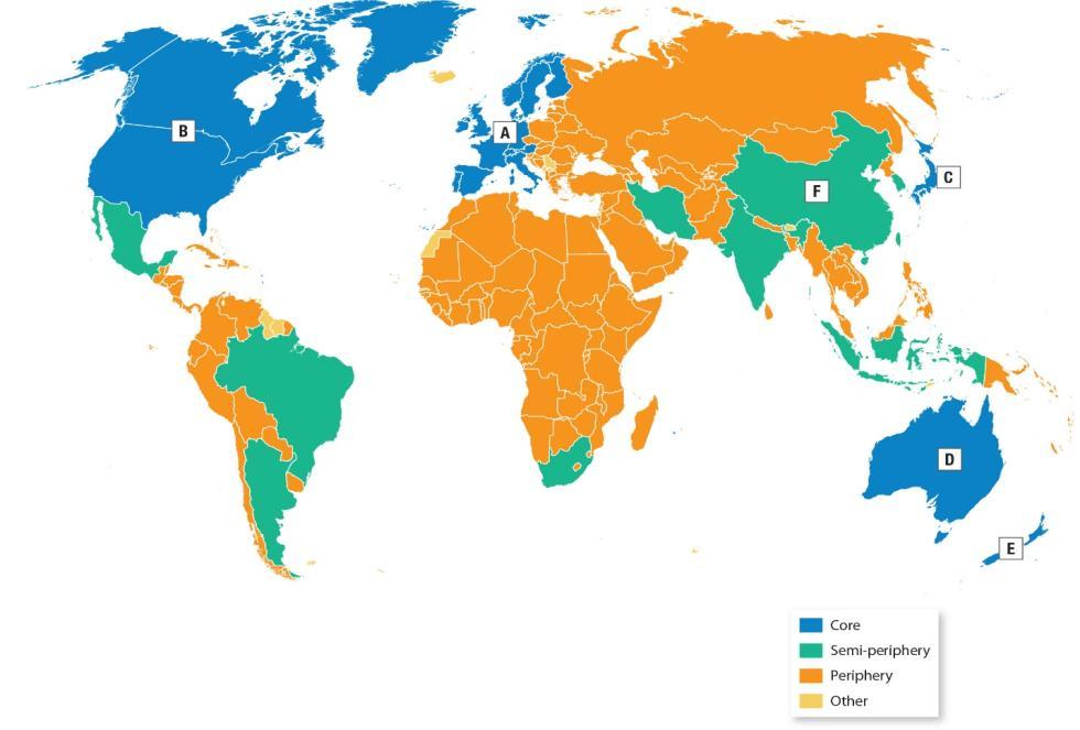
25. Which conclusion can you draw from the map?
© Cengage Learning, Inc.
a. Peripheral countries have few natural resources.
b. There are more core countries than peripheral countries.
c. The number of core countries is growing.
d. There is an uneven spatial distribution of core and peripheral countries.
Chapter 01 - The Power of Geography: Geographic Thinking
e. The balance between core and peripheral countries has undergone dramatic change.
ANSWER: d
26. Based on the map, which part of the world likely has the least wealth and the lowest levels of formal education?
© Cengage Learning, Inc.
a. North America
b. South America
c. Europe
d. Africa
e. Asia
ANSWER: d
27. The region outlined above shows the delivery area served by Crosstown Pizzeria locations. Which classification describes this region?
Chapter 01 - The Power of Geography: Geographic Thinking
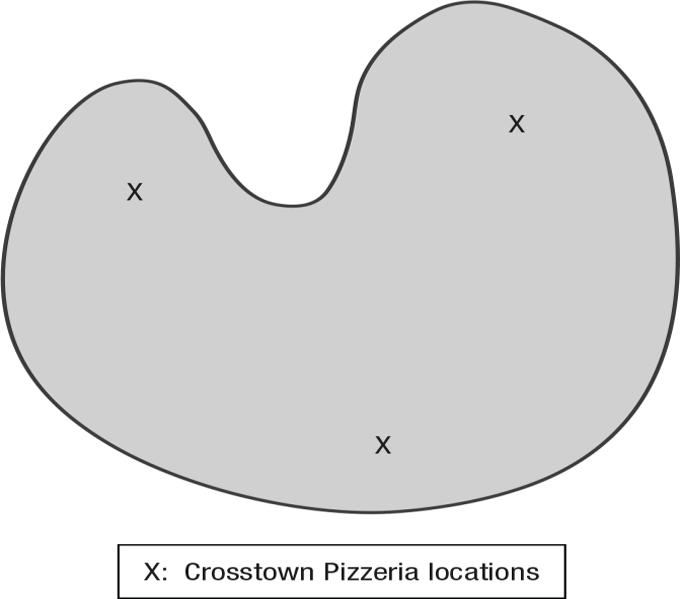
© Cengage Learning, Inc.
a. Formal
b. Mental
c. Perceptual
d. Functional
e. Vernacular
ANSWER: d
28. Which of the following is NOT an effect of time-space compression?
a. You can sell goods to people in China using overnight air services.
b. You can use the internet to view the downtown area of Buenos Aires.
c. You can live downtown and walk to your job, which is also downtown.
d. You can pay your taxes and transmit documents to the government via email.
e. You can work from a home office in the United States for a company in Japan.
ANSWER: c
29. Which of the following is a consequence of globalization?
a. Overpopulation
b. Distance decay
c. Cultural diversity
d. Environmental determinism
e. Sustainable-development challenges
ANSWER: e
30. Which type of thinking is most central to the study of human geography?
a. Botanical
b. Ecological
c. Physiological
Chapter 01 - The Power of Geography: Geographic Thinking
d. Spatial
e. Temporal
ANSWER: d
31. What is a distinguishing feature separating geography from other social sciences?
a. The focus on the relationship between humans and environments
b. The focus on the relationship between different genders
c. The focus on the timing of social changes
d. The focus on the role race and ethnicity plays in societies
e. The focus on the role social structures play in the lives of individuals
ANSWER: a
32. More than any other social scientists, geographers ask questions that begin with:
a. who.
b. when.
c. why.
d. where.
e. how.
ANSWER: d
33. Which of the following best summarizes the meaning of the term “geographic advantage,” coined by Susan Hansen?
a. To understand the importance of spatial variability
b. To understand the strategic development policies of urban metropoles
c. To employ military tactical advantages derived from superior location
d. To maximize profits at the center of the global economy
e. To profit from the specific location of a home in real estate sales
ANSWER: a
34. Looking at an issue from an ecological perspective involves studying the interactive and interdependent relationships among:
a. living things, ecosystems, and human societies.
b. biologists, politicians, and voters.
c. ecologists, scientists, and businesses.
d. animals and plants.
e. people and foods.
ANSWER: a
35. Which perspective helps explain human societies’ dependence on diverse ecosystems for essential resources such as food and water?
a. The economic perspective
b. The biological perspective
c. The political perspective
d. The ecological perspective
e. The logical perspective
Copyright Cengage Learning. Powered by Cognero.
Chapter 01 - The Power of Geography: Geographic Thinking
ANSWER: d
36. When geographers talk about the use of Earth’s land and natural resources in ways that ensure they will continue to be available in the future, they are referring to:
a. availability.
b. efficiency.
c. preservation.
d. environmentalism.
e. sustainability.
ANSWER: e
37. You are a homebuilder looking for sustainable energy sources for your new rural construction project. Which of the following would be suitable?
a. A windmill
b. A coal burner
c. A gas heater
d. A wood-chip burner
e. A steam engine
ANSWER: a
38. Which of the following is an example of sustainable land-use?
a. Amazonian cattle ranches in Brazil
b. Japanese rice terraces
c. A rare-earths mine in West Africa
d. A modern Indonesian palm oil plantation
e. A California cotton farm
ANSWER: d
39. For what issue do geographers rely heavily on data at a global scale?
a. Urban renewal
b. Climate change
c. Sustainable agriculture
d. Desegregation
e. Suburbanization
ANSWER: b
40. Why can’t geographers understand the severity of climate change challenges at a global scale alone?
a. Governments ask for global data only when deciding how to respond to the changing climate.
b. It is local institutions and local governments that make the biggest difference in climate change.
c. Climate change on a global scale tends to look much worse than at the local level.
d. Climate change affects regions differently something global data doesn’t show.
e. Global data requires global cooperation, which geographers don’t do often.
ANSWER: d
Copyright Cengage Learning. Powered by Cognero.
Chapter 01 - The Power of Geography: Geographic Thinking
41. Whether a community is considered diverse, homogenous, or segregated depends to a large extent on the human geographer’s use of:
a. sites.
b. absolute location.
c. situations.
d. formal regions.
e. scale.
ANSWER: e
42. Which of the following has NOT been a factor in the process of globalization?
a. Lower production costs
b. Transportation technology
c. The proliferation of the internet
d. The popularity of social media
e. The expansion of railroad lines in Western Europe
ANSWER: e
43. Which of the following events illustrates how globalization and globalizing technology pose a danger to antidemocratic governments?
a. The Arab Spring
b. The Russian invasion of Ukraine
c. The election of Donald J. Trump
d. The COVID-19 pandemic
e. The terror attacks of 9/11
ANSWER: a
44. One of the chief ways in which governments have promoted globalization since the late twentieth century is through:
a. closing their borders.
b. international trade deals.
c. tax cuts.
d. tax hikes.
e. wars.
ANSWER: b
45. Which of the following is NOT an illustration of the general trend toward globalization in the last 25 years?
a. NAFTA
b. The European Union
c. President Donald Trump’s 2018 import tariffs
d. The United Nations
e. Facebook
ANSWER: c
46. Geography is a discipline committed to the study of the Earth’s surface and dimensions. Other social sciences rely on
Copyright Cengage Learning. Powered by Cognero.
Chapter 01 - The Power of Geography: Geographic Thinking
this data to study how humans and environments relate to each other.
a. True
b. False
ANSWER: False
47. A human geographer researches how people organize themselves socially, politically, and economically and how they interact with and impact the natural environment.
a. True
b. False
ANSWER: True
48. When you do things like traveling around your community, knowing where your destination is, planning a route, considering distance and traffic, and estimating how long your trip will take, you are working as a geographer.
a. True
b. False
ANSWER: False
49. Because geographers work on many of the same questions and problems as experts in other fields in the physical and social sciences, they typically work in related disciplines rather than their own.
a. True
b. False
ANSWER: False
50. While most physical and social sciences focus on either the environment or on humans, geographers focus on the relationship between the two.
a. True
b. False
ANSWER: True
51. When geographers want to combine spatial and temporal analyses, they need to collaborate with historians.
a. True
b. False
ANSWER: False
52. When human geographers take a spatial perspective, they are studying when the events of human societies occur.
a. True
b. False
ANSWER: False
53. A geographer studies the way an isolated rural community in Central Asia secures its food and water supply. This geographer most likely employs an ecological perspective.
a. True
b. False
ANSWER: False
Name: Class: Date:
Chapter 01 - The Power of Geography: Geographic Thinking
54. A geographer studies the relationship between abandoned ancient ruins and the local mountain range in a region in Central America. This geographer most likely employs an ecological perspective.
a. True
b. False
ANSWER: False
55. A model is a representation of reality that presents all features or relationships in a generalized form.
a. True
b. False
ANSWER: False
56. In the eighteenth century, early geographers developed an approach to their field known as possibilism, which is now mostly unfamiliar to the discipline.
a. True
b. False
ANSWER: False
57. By the middle of the twentieth century, geographers drew on environmental determinism to challenge established patterns of racism, colonialism, and imperialism.
a. True
b. False
ANSWER: False
58. Human-made dams and canals, aqueducts, and cities all make it easy to subscribe to the theory of environmental determinism.
a. True
b. False
ANSWER: False
59. Geographers often point out that, in the long run, no energy sources are available perpetually, not even sun and wind.
a. True
b. False
ANSWER: False
60. If humans want to preserve the delta of the Okavango River Basin in northern Botswana, argues National Geographic Explorer Adjany Costa, they should remove themselves from that environment entirely.
a. True
b. False
ANSWER: False
61. In the early eighteenth century, the founders of the city of New Orleans decided that the advantages of the city’s site outweighed the disadvantages of its situation.
a. True
b. False
ANSWER: False
Chapter 01 - The Power of Geography: Geographic Thinking
62. Ironically, climate change will most likely neutralize the disadvantages of New Orleans’ site while nullifying the benefits of its situation.
a. True
b. False ANSWER: False
63. Geographers understand that what happens at one scale affects processes at other scales, and data at different scales is necessary to fully understand issues.
a. True
b. False ANSWER: True
64. The map of food insecurity in the United States demonstrates that economic issues are best illustrated at a national or state-by-state scale.
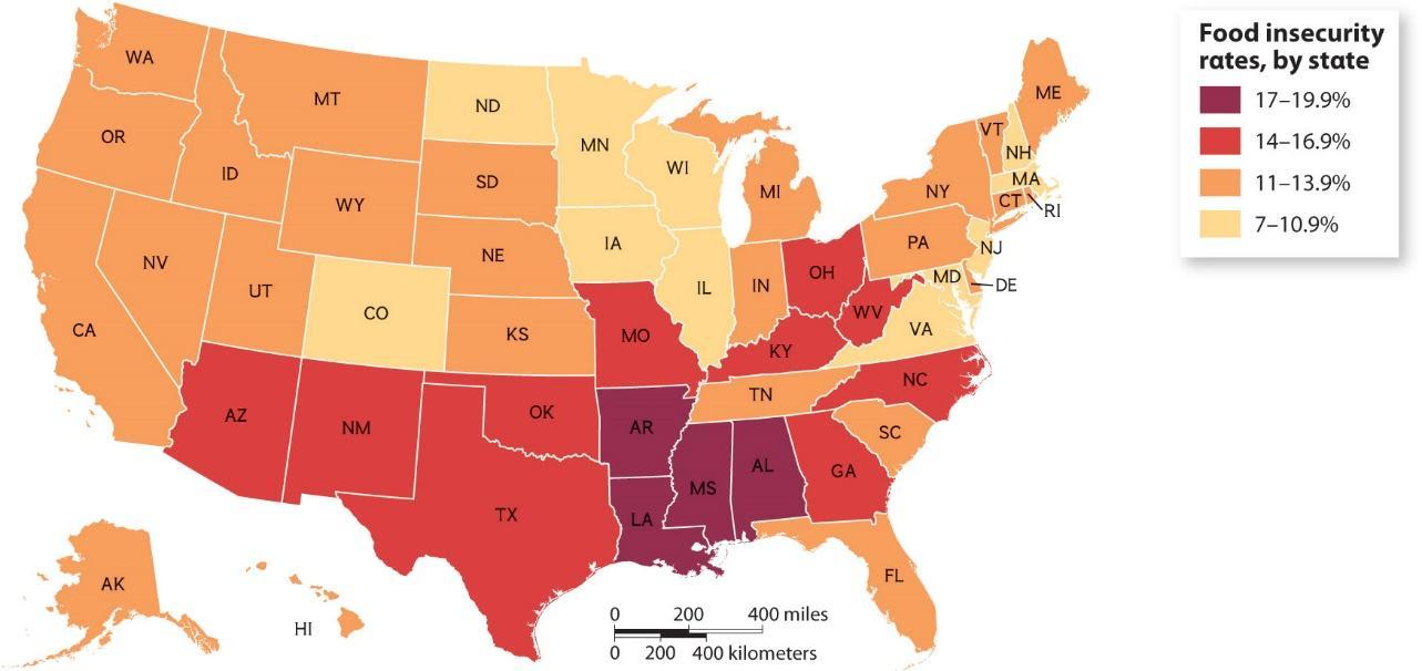
a. True
b. False
ANSWER: False
65. This map of food insecurity in Mississippi illustrates that poverty is an isolated problem in the United States.
Chapter
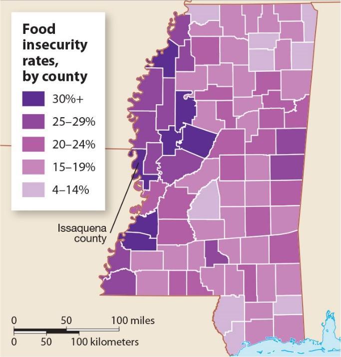
© Cengage Learning, Inc.
a. True
b. False
ANSWER: False
66. Explain how geographers use both the spatial and ecological perspectives to interpret and explain spatial processes on Earth.
ANSWER: Responses will vary but should demonstrate an understanding of the definition of spatial perspectives as referring to where something occurs, and of ecological perspectives as referring to the relationships between living things and their environments.
67. Use a specific example to define absolute location and relative location, and explain the usefulness of each.
ANSWER: Responses will vary but should differentiate between absolute location as a description of an exact location, and relative location as a description of where a place is in relation to other places or features. Absolute place may include the coordinates of longitude and latitude, while relative location is a description of places in relation to other places. Students should note also the relative usefulness of these two types of location; for instance, absolute location is useful because it means the same thing to everyone, while relative location can take advantage of a group’s common knowledge of the location of other places.
68. Identify three physical and three human characteristics of a particular place, and explain how they all contribute to the character of the place.
ANSWER: Responses should include three physical characteristics (climate, landforms, soil, water sources, vegetation, or animal life) and three human characteristics (language, religion, political system, economic system, population distribution, architecture, or quality of life). In their combinations, they contribute to the character of, say, an industrial manufacturing (human factor) town at the mouth of a river (physical factor), or a sprawled community of farms (human factor) in the irrigated (human factor) fertile central valley (physical factor).
69. Compare the concepts of site and situation.
ANSWER: Responses will vary but should demonstrate an understanding of the difference between site (a place’s
Chapter 01 - The Power of Geography: Geographic Thinking
absolute location and physical characteristics) and situation (a place’s location in relation to other places or its surrounding features, connections to other places, political associations, and economic and cultural ties).
70. Explain what geographers mean by flow, and why the concept is an essential area of geographic study.
ANSWER: Responses should demonstrate an understanding of the term flow as it is used in geography. Students should note that flow helps geographers understand the movement of people, goods, and information as well as the impact of these movements on societies.
71. Use a specific example to define a formal region on the basis of physical characteristics and distinguish it from nearby regions.
ANSWER: Responses will vary, but students should provide a specific example of a formal region that is defined according to a landform, climate area, or other physical characteristics.
72. Use a specific example to explain how one place can belong to multiple regions and what that variety of regions says about the character of the place.
ANSWER: Responses will vary, but the examples should illustrate an understanding of how one place can belong to multiple regions, largely because the boundaries between regions are not clearly defined and are often transitional or overlapping. The example provided in the book is the U.S. Southwest, which is thought of as one distinct region, and El Norte in Mexico, which is considered to be its own region, though both areas can also be considered a single region. There are many other examples that might be included, particularly if students include formal regions (such as New England) versus perceptual regions (the East Coast).
73. Use a specific example to define a formal region on the basis of human characteristics, and distinguish it from nearby regions.
ANSWER: Responses will vary, but students should note a specific example of a formal region that is defined on the basis of human characteristics such as language or religion.
74. Explain the role of the node in a specific functional region.
ANSWER: The node is the focal point of a functional region, such as the downtown of a city or the hub of a transportation network.
75. Compare the clarity of the boundaries of formal and perceptual regions using specific examples of each.
ANSWER: Responses will vary but should demonstrate an understanding that the boundaries of formal regions are clearer than those of perceptual regions. Thus, while the nations of the Eastern Bloc under the Warsaw Pact during the Cold War constituted a formal region, today’s Eastern Europe is a perceptual region that depends on people’s ideas of where Europe ends and Asia begins. Similarly, the American South today is a perceptual region which may or may not include states like Maryland, Texas, Arizona, or Kentucky. During the Civil War, “the South” was a formal political region organized in rebellion against the United States.
76. Explain how Wallerstein’s description of the world as one entity with a single market and labor force reflects the rise of globalization.
ANSWER: Wallerstein’s world system theory describes the world as one entity with a single market and labor force. This demonstrates the rise of globalization, which has contributed to the interconnectedness of countries around the world and the businesses within them.
77. Compare core-periphery terminology to the terms developed country and developing country.
ANSWER: The terms developed and developing were used to describe countries beginning in the 1950s, but critics believe that they incorrectly assume that these countries want or need to “catch up” with Western ideals. The
Chapter 01 - The Power of Geography: Geographic Thinking
terms core, semi-peripheral, and peripheral are used instead to describe countries at different levels of the world hierarchy.
78. Identify two features of peripheral countries.
ANSWER: Possible responses include having less wealth, lower education levels, less sophisticated education, less stable government, poorer services such as health care, inferior transportation networks or infrastructure, inferior connections within and beyond the country, and less ability to support economic activity.
79. Explain the degree to which Wallerstein’s theory focuses on economics and does not address other human activities.
ANSWER: Responses will vary but should demonstrate an understanding that the world system theory focuses on the economic relationships among countries, particularly the exploitation of peripheral countries by core countries. A criticism or limitation of the theory is that it does not consider political or social relationships.
80. Explain how semi-peripheral countries differ from both core and peripheral countries.
ANSWER: Semi-peripheral countries are in the process of industrializing and may be active in the manufacturing and exporting of goods. They have better connections than peripheral countries, but they are not as strong or “advanced” as core countries.
81. Identify one country in each of Wallerstein’s categories and explain why each is so classified.
ANSWER: Responses will vary, but students should identify one core country, one semi-periphery country, and one periphery country, as shown in the “World System Theory” map. Responses should further identify the core country as being at the top of the hierarchy (economically and politically dominant); the periphery country being at the bottom (with less wealth and inadequate infrastructure to support economic activity); and the semi-periphery being between the two (with both core and periphery processes occurring).
82. Explain what factors limit peripheral countries from advancing in the hierarchy of Wallerstein’s rankings.
ANSWER: Responses will vary but should include an understanding of the limitations and challenges that may prohibit peripheral countries from advancing in the hierarchy. These may include any of the problems identified in Task (C), or focus on the exploitation of peripheral countries by semi-peripheral and core countries.
83. Compare the scales of the two maps of New Orleans.
Chapter 01 - The Power of Geography: Geographic Thinking
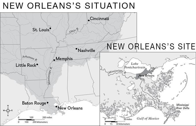
© Cengage Learning, Inc.
ANSWER: The situation map is at a smaller scale than the site map. It shows a larger area with fewer details. The site map shows a smaller area with more details.
84. Identify aspects of a place’s location that would be included in the description of a place’s site.
ANSWER: Responses should identify the following aspects of site: absolute location, landforms, climate, and resources.
85. Identify aspects of a place’s location that would be included in the description of a place’s situation.
ANSWER: Responses should identify at least two relevant aspects of situation, such as proximity to transportation routes such as roads, rail lines, and waterways; political associations; and economic and cultural ties.
86. Use the two maps to describe New Orleans’s site and situation.
Name:
Class:
Chapter 01 - The Power of Geography: Geographic Thinking
© Cengage Learning, Inc.
ANSWER: Responses may vary but should point out that New Orleans is located on the Mississippi River, on the Mississippi River Delta, with Lake Pontchartrain to the north. It is located in Louisiana, about 100 miles southeast of Baton Rouge.
87. Using the information in the two maps, explain why New Orleans’s situation contributed to its growth.
Copyright Cengage Learning. Powered by Cognero.
Chapter 01 - The Power of Geography: Geographic Thinking
© Cengage Learning, Inc.
ANSWER: Responses may vary but should point out that New Orleans’s location on the Mississippi River near the Gulf of Mexico made it uniquely suited to be a port, serving other cities on the Mississippi River and its tributaries, including Baton Rouge, Little Rock, Memphis, Nashville, St. Louis, Cincinnati, and cities farther north.
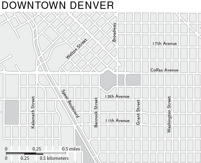
88. Describe the scale of analysis used in the map.
Name:
Chapter 01 - The Power of Geography: Geographic Thinking
© Cengage Learning, Inc.
ANSWER: The map has a local scale of analysis.
89. Explain whether the map better illustrates Denver’s pattern or its density, and why.
Copyright Cengage Learning. Powered by Cognero.
Name:
Chapter 01 - The Power of Geography: Geographic Thinking
© Cengage Learning, Inc.
ANSWER: The map better illustrates Denver’s pattern because it shows the way that the streets are arranged.
90. Using the place names shown on the map, describe the relative location of the park at the center of the map.
Copyright Cengage Learning. Powered by Cognero.
Name:
Chapter 01 - The Power of Geography: Geographic Thinking
© Cengage Learning, Inc.
ANSWER: Responses should describe the location of the park in relation to one of the streets; for example: The park’s relative location is south of 17th Avenue, east of Speer Boulevard, and 0.5 miles north of 11th Avenue.