
6 minute read
The Glacial Lakes Trail Comes to Sibley State Park

THE Glacial Lakes Trail COMES TO Sibley State ParkStory & photos by Jan Lasar
SIBLEY STATE PARK’S 2,500 ACRES PUT IT SOLIDLY IN THE TOP ONE-THIRD OF MINNESOTA’S STATE PARKS AS FAR AS
SIZE GOES, BUT IT ALSO CLAIMS A SEAT IN THE TOP TEN WITH 200,000 ANNUAL VISITORS. IT CAN BE A BUSY PLACE, BUT THINGS CALM DOWN WHEN THE LEAVES ARE OFF THE TREES. IT TURNS OUT A MILD WEEKEND IN NOVEMBER WAS THE PERFECT TIME FOR A VISIT.
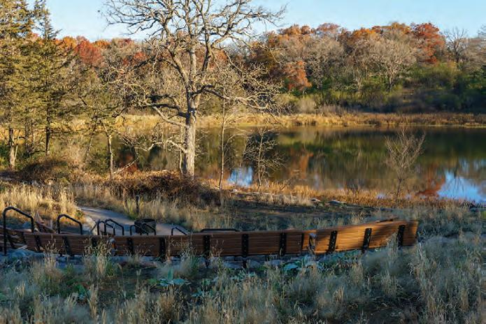
Above: En route to Mount Tom / Right: The new amphitheater next to to the interpretive center
Jen and I arrived about mid-day on a Friday with great plans of hiking and exploring a new section of the paved Glacial Lakes Trail inside the park. It was a great plan, but after setting up camp we decided to enjoy the mild weather and wonderful sunshine, sit in our camp chairs and watch a few more travel trailers pull into Oakridge Campground until it was time for a bonfi re and a quiet night. Th ere were no excuses on Saturday morning as Jen’s parents, Th eresa and Mike, arrived early to join us for a day of hiking. Th e plan was to take a look at the new amphitheater in the park, search for the place where the new bike trail passes under Highway 71 and then spontaneously pick another route using our Avenza map app. Shortly after getting on the trail there was a split and like so many times in life, we took the wrong turn. Th is trail wasn’t on any maps, so we were relying on our sense of direction, which turned out to be a hilarious choice. Instead of veering southeast we went northwest and walked through the Lakeview Campground, ending up at the boat landing on Andrew Lake. From there, an old section of paved trail took us out to a road near the canoe portage between Andrew and Henschien Lake.


For all the times I had visited Sibley State Park, this older, paved trail had somehow remained hidden to me.
We continued to the scenic overlook near the horse camp and took a break. Temperatures had crept up to 60 degrees and the jackets were coming off . From the top of our little hill we had a great view of the rest of the park’s other rolling hills. Besides a few dots of burnt orange and rusty browns the forest’s fall colors were gone and our path to Mount Tom was a green ribbon through tan grass and was swallowed by the woods in the distance. On top of the next rise, the roof of the Mount Tom observation tower stuck out over the treetops and we began working our way toward it. Th is leg of our hike was a wide, mowed path through the woods for people on foot and on horses. After a short walk down a gravel road, we reached the Hiking Club Trail. Near Mount Tom it’s a steep and rocky climb that packs a punch, but, fortunately, isn’t very long.
At the Little Mount Tom overlook, the little brother of the more popular Mount Tom overlook, we stretched the legs and took a selfi e, then set out for the real deal.
At the parking lot I turned toward the observation tower to read the interpretive sign at the bottom. I was just about to start hiking up that last hill when I turned around and noticed the crew was gone. Th e sound of footsteps through leaves came from the woods and a voice announced: “We’re not going that way.” It was mutiny. Outvoted three to one I had no choice but to comply.
Right after Mount Tom the Hiking Club Trail runs on a very distinct, fl at ridge before it tucks back into the woods. Th is last leg back toward the campground was again very hilly, but not impossible to hike. By this time of the day the temperatures were nearing the mid-sixties and it felt more like late April than early November. We even met a fellow hiker who had taken off his shirt to cool down. By contrast, there were six to nine inches of snow on the ground at the same time the year prior. Back at camp we had dinner and enjoyed the rest of the sunny day.
BIKE, HIKE & KAYAK
explore. more.

VISITMARSHALLMN.COM 507-537-1865 MARSHALL, MN

Since 1993 the Parks & Trails Council of Minnesota has saved 189 acres of land, to be added to Sibley State Park. Find out more: www.parksandtrails.org/portfolio/sibley-state-park
Th e next day we wanted to fi nd out exactly where that brand new paved bike trail goes. It was so brand new that the construction marker stakes were still in the ground and newly seeded grass was just beginning to sprout along the edges of the trail. We walked southeast from the interpretive center toward the park road, through woods, then prairie and back into the woods. A natural ridge looked like it had been put there just to provide a fl at surface for the trail to cross through a wetland, and it was lined with mature oaks that had been there many years. Eventually, we crossed the park road and ended up in the open prairie. Th e trees disappeared, the view opened up and we could see two people off in the distance, over the next hill.
Th e two women who lived nearby, were excited to have a new trail in their backyard. Since the construction crews moved out, they said, this new section of the Glacial Lakes State Trail has seen a lot of use.
At the intersection of Highway 71 and County Road 40, the trail reached the park boundary. A tunnel took us under the road and that was as far at it’s been built. From here, it’s just about three and a quarter-miles into New London and the connection to the Glacial Lakes State Trail, which is currently being worked on.
To understand why this short piece inside the park is a big deal, a look back in time reveals that this is one tiny step in the fulfi llment of the original plan for the Glacial Lakes State Trail. It was authorized in 1971 to originate at Kandiyohi County Park on the north end of Green Lake, travel to Sibley State Park, on to Glacial Lakes State Park and end at Lake Carlos State Park. Th e master plan was amended in 1993 to make the trail originate in Willmar and head northeast to Richmond through New London and Paynesville, with a possible connection to Saint Cloud thrown in. Th e extension north to Glacial Lakes and Lake Carlos State Parks was left in. A master plan for the extension into Sibley State Park was done in 2012, and fi fty years after its conception, the Glacial Lakes State Trail is inching closer to completion.
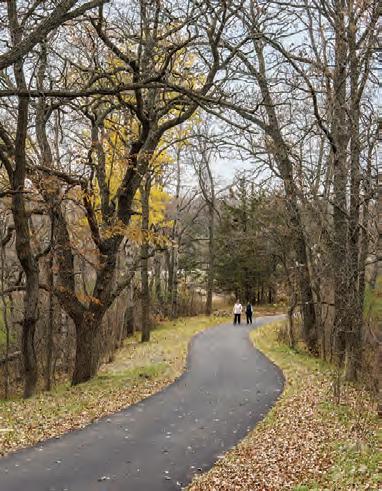
Below: The Glacial Lakes State Trail enters the park at the southeast corner and winds through rolling prairie hills. / Right: At the equestrian campground


