4 minute read
A Trail Saved, a Forest Reborn Powwow Trail

A TRAIL SAVED, A FOREST REBORN
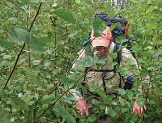
Located north of Isabella, Minnesota, in the heart of the Boundary Waters Canoe Area Wilderness, the 25-mile Powwow Trail is a treasure almost lost following the devastating Pagami Creek fi re of 2011. Instead, in collaboration with the Forest Service, volunteers from the Boundary Waters Advisory Committee (BWAC) began the enormous project of recovering the trail. That meant finding it, fi rst of all, and then using hand tools to saw JUNE 2018: and lop a path through nearlyimpenetrable obstacles left in the fi re’s aftermath—dead trees in tangled masses sometimes a Deadfall and emerging growth make fi nding the original trail quarter mile long, and sun- diffi cult. loving trees and brush that quickly overwhelmed the tread. Th e work continues: a good storm still brings down barriers to be limbed and sawn and hauled aside, and brush comes up relentlessly. However, the trail is once more well defi ned, and circumnavigating it is now challenging but manageable for experienced, well-prepared hikers. Eight campsites are open. Th e tread is gradually being reestablished, footstep by footstep. To walk the Powwow Trail today is to experience a miracle of the natural world: the northern forest’s regeneration after fi re, a process it has been practicing since the glaciers receded. Volunteers who worked on the trail from the beginning of the recovery eff ort are particularly conscious of the metamorphosis. Martin Kubik, founder of BWAC, circumnavigated the Powwow the year after the fi re. “Most of the ground was bare,” he recalls, “with sedge grasses, bindweed, and fi reweed representing about 30% of the ground cover. As the years pass, vistas that had been opened by the fi re are now closing again. “On the north loop, six years ago,” he recalls, “the jack pines were only three to fi ve feet tall, and we could see Pose Lake from the heights of the trail at many spots, along with boulder and rock formations in between. Now this view is disappearing.” John Mattson, another long time BWAC volunteer, recalls opening his car door in the trailhead parking lot in fall 2013 and being “met with the strong, pungent smell of burned wood,” and everything he touched coming away ‘dirty with soot’. Th e smell and the soot are all gone now.” Like Kubik, he recalls the bindweed everywhere, grabbing at his boots, and places like the junction where
SEPTEMBER 2013: New growth after a forest fi re sometimes makes trails impassable.
Martin Kubik photo
By Lon Otto
Lon has been a trail maintenance volunteer with BWAC since spring of 2018. He is the author of three collections of short stories and a novel, published this spring: The Flower Trade (Brighthorse Books). He lives in St. Paul, Minnesota, is Professor Emeritus at the University of St. Thomas in St. Paul, and has taught for many years in the University of Iowa Summer Writing Festival.

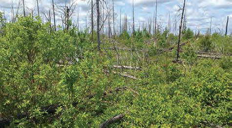
Martin Kubik photo the trail splits into a loop, heading north and west, that were wide open for several years after the fi re and are now thick with jack pines that the trail corridor cuts through. BWAC clearing crews from 2017 and 2018 MAY 2022: Standing, dead trees rise above fresh, new Jackpines at Rock of Ages Lake. Verena Walther photo recall taking group photos in front of a looming rock formation just a few yards drumming of ruff ed grouse all along off the trail between Fallen Arch Lake the Powwow Trail, long a destination and Flapper Creek that today is almost completely obscured by vegetation. Vast sweeps of jack pine, evolved to release seeds from tightly knotted cones when exposed to fi re, were the fi rst postfi re woody seedlings to emerge after the 2011 fi re. Other conifers came later: Christmas-tree-perfect black spruce; wispy tamaracks sprouting from damp peat; fresh-faced cedar colonies beneath their twisted grandparents; and longneedled red and white pines, descendants of giants that drew the loggers. Ferns, large-leaved aster, creeping dogwood, pearly everlasting thickly obscure the tread after the explosive growth of a wet spring. Broad-leaved thimbleweed grows shoulder-high by fall in the trail west of Pose Lake. Th e poplar, birch, alder and willow that beavers depend on grow in large stands in many areas, their healthy growth suckering over the trail but tall enough now to cast welcome shade. Th e ubiquitous beavers are joined by other animal life returning to the forests and lakes and bogs. Moose and wolf scat is common. Lynx have been spotted, and snowshoe hares. Chipmunks and little red boreal squirrels now lurk at Powwow Trail campsites. Hikers see and hear the for fall hunters using historic logging roads to access their habitat. White throated sparrows sing thrillingly. In May of 2022, hikers camped at Mirror Lake were kept awake in the middle of the night by the obsessively repetitive calls of a whippoor-will. All Boundary Waters hiking trails are dynamic. Th e Powwow’s terrain varies from the rolling, relatively level and straight south and east sides, where it follows old logging roads, to the more rocky, rugged, elevation-varied west and north sides, often skirting lakeshore. Trails also change season by season and year by year. A spell of dry or wet weather can make a huge diff erence in hikers’ experience. Rain, snow, or wind transform conditions overnight. What is distinctive about the Powwow Trail is the enormous, complex changes involved in recovery from a forest fi re. With a few isolated “green zones”—unburned areas—standing as promises of what is to come, the burned wilderness of the Powwow Trail moves steadily closer to becoming once more a mature forest. LEARN MORE: WWW.BOUNDARYWATERSTRAILS.ORG
