18 minute read
Goal #7 Land Acquisition


Increase the County’s public open space in areas of need, growth, and environmental value.
It is necessary to balance the need to restore streams, provide vital habitats, and manage invasive species, while meeting the needs of a growing population. Despite efforts to acquire land over the past decade for conservation and to create more equitable public access, growth pressures are driving up land value and making land acquisition for open space increasingly difficult. Mecklenburg County currently owns 21,000 acres of parkland. The 2015 Master Plan recommended acquiring an additional 1,300 acres for current population growth projections. Between 2014 and 2020, 1,802 acres have been purchased for open space,12 but land will need to be purchased to continue to meet the needs of a growing population and get ahead of development throughout the county. 7.1 Advocate for incentives for public open space in new developments by coordinating with ongoing planning efforts and local development regulations.
Advertisement
Mecklenburg County’s population continues to grow, and Mecklenburg Park & Rec has faced challenges to acquire land in the places that are growing fastest. Looking ahead, Mecklenburg County’s population is projected to increase by another 400,000 residents in the next eighteen years. To maintain existing levels of service (19.1 acres per thousand residents), the County will need an additional 8,000 acres of new park space over the next 20 years to support the same level of service for new residents as well as plan for important environmental protections. The service ratio will decrease to 13.6 acres by 2039 if new land is not acquired. This aim is echoed by the Environmental Leadership Action Plan, which lists the goal of acquiring 8,000 acres by 2025.13 Achieving goals like the “10- minute neighborhood” standard recommended by the Charlotte Future 2040 Comprehensive Plan will need land acquisition coupled with a targeted, location based strategy. This goal strives for all Charlotte households to have access to essential amenities and services within a safe 10-minute walk. Parks, plazas, and nature preserves are listed as some of these essential amenities. The County should stand by its desire to provide an exceptional level of service to ensure that it continues to meet environmental and recreational goals, while exploring policies that seek to capture value from new development and channel it into enhanced or new resources for the community. One way to capture this value is through partnerships with developers. In this process, private developers are active participants in the creation of public space. Local regulations could ensure that redevelopments, like the former Eastland Mall redevelopment, include publicly accessible open space that helps to close a
gap in park access and provides amenities that align with community desires. This legislation could be enacted through the redevelopment rezoning process and enhance community relationships with future development projects. In the Eastland Mall case, such legislation could provide an opportunity for the current skate park to remain.
Another way Mecklenburg Park & Rec can get ahead of growth is by working with the City of Charlotte and the six towns to create developer incentives for tree canopy and open space contributions. While many tree preservation incentives occur on privately owned land, programs like the Charlotte Tree Canopy Preservation Program can integrate these efforts into City or County owned land. Mecklenburg County currently collaborates with municipalities to ensure land development plans align with County and local goals and regulations for sustainable development. However, regulations and policies vary from municipality to municipality, requiring the County to cater its approach to open space preservation with the unique goals, character, and development patterns of each place. These varied regulations are not always tied to concrete and regenerative financial mechanisms. Currently, Mecklenburg County only charges fees related to land development and stormwater impacts at the municipality level. Since the County has limited land development authority, the County should consider advocating for municipal-led impact fees in support of expanded and enhanced open space investments at the local level. While it is true that developers have helped to fund open space interventions, implementing a standard impact fee would provide a steady and reliable tie to open space acquisition, management, and wellness. The County should work with municipalities to collect these fees, as it does not have legal mechanisms to do so on its own. The City of Raleigh, North Carolina provides a strong example. A portion of Raleigh’s impact fees go directly to their Parks, Recreation, and Cultural Resources Department. Fees pertaining to urban forestry, facilities fees, and fees in lieu are “indexed on an annual basis using the Consumer Price Index (CPI) and the Engineering News-Record (ENR). The CPI annual change is 1.6%. The ENR annual change is 3.03%.”14 Mecklenburg Park & Rec also has fees for programming, which are based on Mecklenburg Park & Rec’s cost recovery matrix. Raleigh’s open space fees vary based on type of dwelling (single-family or multi-family) and zone. These fees range from $952 per unit to $1,557 per unit.
The city is segmented into four zones, each with their own rate for impact fees. By creating these impact fees, Raleigh is able to incent residential density, while providing funding specifically for open space, schools, and roads. Additionally, it instills a culture of environmental responsibility by charging developers for losses in tree canopy. Raleigh also has an interactive online dashboard, where developers can receive an estimate of their impact fees based on type of construction and location. However, fees such as these often need community buy-in. Raleigh needed special legislation from their General Assembly to impose these impact fees. Impact fees incurred at the local level could also be tailored to reflect different development types. Fees could be on a sliding scale, relative to number of building units. Buildings with more units could incur a higher fee. Also, impact fees are not the only option. In lieu of impact fees, municipalities could accept gifts of land, or land dedications.
Municipalities could also direct prospective impact fees into a land acquisition fund. Bolstering this fund would allow the County to work with municipalities to act with greater immediacy should land come to market. Another option is to use this revenue in a flexible account by earmarking revenue collected from a fee system that could complement the CIP timeline and allow for a mix of reactive and proactive project implementation. Feedback from residents articulated a desire for development that contributes to expanding the open space network and responds to environmental needs. Many people asked for
7.1 Key Actions
Collaborate with other agencies to create a standard impact fee that provides a steady and reliable tie to open space acquisition, management, and wellness:
• Preserve 19.1 acres of open space per thousand residents as the County grows.
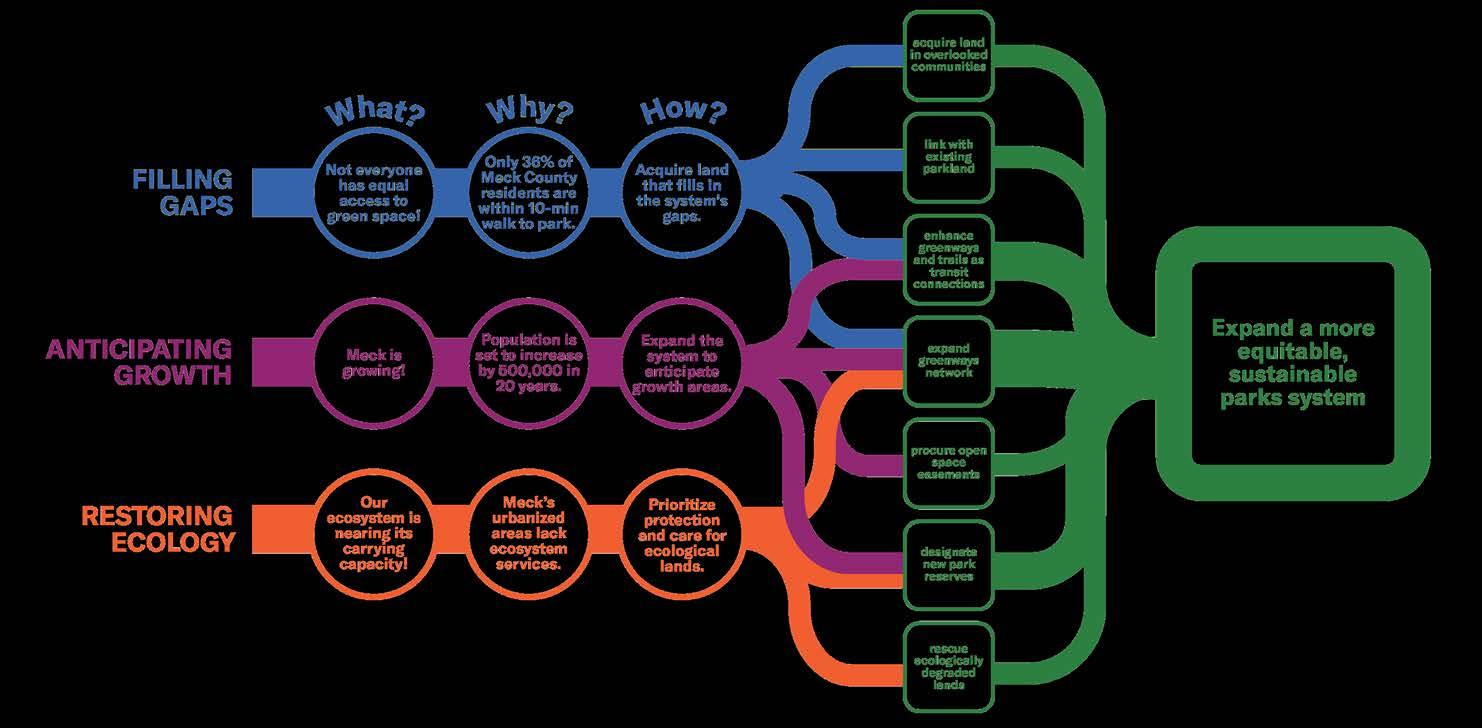
• Balance three acquisition aims: fill system-wide gaps, anticipate growth, and protect the environment.
• Coordinate with City of Charlotte
Unified Development Ordinance (UDO) to address land acquisition and easements through the development process. • Work with municipalities to create impact fees in support of increased park land acquisitions.
developers to acknowledge their responsibility to be environmental stewards. Mecklenburg Park & Rec has already committed to restoring its tree canopy and public and municipal support exists. From there, they could incrementally add impact fees to offset the effects of development.
Facilitate relationships with developers to help achieve County goals:
• Support municipality-led developer incentives for tree canopy and open space contributions.
• Clearly articulate roles and responsibilities for design, construction, and maintenance of any new open spaces in new developments.
7.2 Create a prioritization framework for land acquisition to balance development with equity goals for addressing service gaps in under-resourced communities.
Land acquisition is a priority goal, but it may be one of the most challenging steps to implement. The plan sets a goal of 19.1 acres for every thousand residents so that Mecklenburg Park & Rec can protect natural resources and critical habitats, while providing all residents with nearby high quality open space. To accomplish this, the county needs a prioritization framework for land acquisition and funding that fosters new public space, while creating a clear understanding of service standard levels. The land acquisition framework is recommended to achieve three aims: fill system-wide gaps, strategically anticipate growth, and protect the environment all while maintaining a high level of service. It is important that one priority does not supersede others. Given the opportunistic nature of land opportunities, Mecklenburg Park & Rec continue to appropriately fund, proactively search for, and react to opportunities in all categories. When the County creates this framework quantitative programs like the greenprint software program should be combined with qualitative metrics like community feedback. To expand access across the County and achieve the goals of a land acquisition framework, the County should look beyond traditional methods of land acquisition to more creative approaches, many of which are currently used by the County but could be expanded. The following seven approaches provide a foundation for a robust land acquisition strategies built upon relationships, diverse funding streams, and regulations.
Only 38% of Mecklenburg County residents live within a ten-minute walk to a county-owned or municipal park. However, walking is not the only mode of travel in the county. Residents also bike, ride transit, and drive. Using Meck Playbook as a guide, Mecklenburg Park & Rec should focus land acquisition for recreational use or public access to areas of the County with demonstrated need. In this case, need can be based on the social vulnerability index, or identified in places where land is being developed rapidly. The assessment identified places within the County where physical gaps in access continue to exist. It takes into account prevailing commuting patterns outside of the City of Charlotte limits, even as neighborhoods become more dense. The zones identified do not have access to a park within a ten minute walk and often are also cut off from a park within a five minute drive. This indicates where new parkland investments are most needed (See Figure 1.12 or Strategies 2.1 and 2.2 for more detail on how these areas were identified). New growth, or places where new development projects have started in the last year, are focused in largely suburban and rural areas along existing light rail like the LYNX Blue Line and proposed light rail like the LYNX Silver Line. Multi-family developments are clustered closest to sustainable transportation options, while single family development is focused just outside of Uptown’s boundaries and at the edges of the County.
Parkland expansion enables the County to grow amenities within parks, create new connections to neighborhoods, and link these neighborhoods to civic institutions and community destinations like libraries, schools, and bodies of water. The majority of the County’s local neighborhoodserving parks are too small to support a diverse
mix of programs. They also contain fixed park infrastructure that cannot nimbly reflect the changing demographics and community needs that surround them. Expanding park space, where possible, will create safe connections and grow healthy recreation habits among surrounding neighborhoods. Land can be acquired to create new parks (specifically benefiting communities with limited park access) or expand program offerings.
Enhance the greenways network
Partnerships that expand access to greenway trails to better connect the region provide a layered approach to connecting the County’s regional trail and habitat network. Greenway trails are multi-modal and connect to parks and employment centers, which make them valuable for recreation and commuting.
Procure open space easements
Not all land acquisition needs to be fee-simple, especially as land values in many parts of the County become too expensive for large land acquisitions. Easements with regional infrastructure organizations, land trusts, and private developments or homeowners’ associations can quickly help to expand public access.
Designate new Parkland Reserves
Parks and open space are critical for many reasons including enhancing public health infrastructure, resilience to climate change, and protecting irreplaceable habitats. Once this lens is accepted, these County-owned lands are seen as some of the most important lands in the region. Working with local governments to create a Parkland Reserve overlay within municipal ordinances will ensure that parkland is protected long term until it is developed into a park. It is possible for some park types to co-exist with other land uses including roadway infrastructure. However, more environmentally fragile areas sensitive to damage will need to be considered for protection during the park planning process . This understanding would limit activities with negative effects on the park’s operations and subsequently, its role in the community. Similar to the Charlotte Future 2040 plan’s “neighborhood conservation overlay district” idea, a Parkland Reserve overlay would help to mitigate impacts to existing parks and open spaces, including utility or infrastructure projects, prior to development. To protect any critical habitats and sensitive environmental areas from potentially harmful development, any projects should require feedback from Natural Resources, and possibly an external environmental study to ensure impacts to these areas are limited.
3.18 A proposed Land Acquisition Strategy should be multi-dimensional, aiming to fill gaps and anticipate growth while restoring native ecology.
manage and protect park development
As the region continues to draw more people to live and work, development pressures continue to place undue burden on critical ecosystems and historically meaningful places. Mecklenburg Park & Rec, other environmentally minded organizations, and volunteer networks can be advocates and stewards of the places with cultural, historical, and environmental value.
To prepare for future park investments that are just outside of the County’s capacity to acquire on its own, partnerships will be invaluable. As an example, Queens Park, the conceptual “central park” at the northeast edge of Uptown, would help to fill in gaps in highly dense areas and create a regional attraction for residents and visitors alike.
7.2 Key Actions
• Acquire land in areas of the County that have limited access to parks (within ten minute walk in dense areas and five minute drive in less dense areas) or demonstrated need.
• Purchase land that will expand a park’s footprint, create safe connections, and grow healthy recreation habits among surrounding neighborhoods.
Enhance the greenways network:
• Partner to close greenway gaps.
Procure open space easements:
• Work with regional infrastructure organizations, land trusts, and private developments or homeowners’ associations to expand public access.
Designate new park reserves:
• Work with local governments to create an overlay for future parklands to ensure protection prior to parkland development.
• Require an environmental review to ensure impacts to these areas are limited..
Protect ecologically valuable lands and areas with unique value. Partner to invest in once in a generation opportunities.
7.3 Consistently apply a new classification system to clarify internal operations and reinforce level of service standards.
Most people choose to visit a park not because of its ownership, but because they want to participate in a specific experience. The classification system should reflect community expectations for a trail, facility or open space. Park spaces are classified by types to aid in design and acquisition decisions for land, facilities, and distribution of amenities that respond to needs, diversify experiences, and ensure consistent maintenance. Mecklenburg Park & Rec historically used the National Recreation and Park Association (NRPA) park classification system, which emphasized size and uses, but did not account for unique needs or attributes. Today, alignment with the NRPA system is less necessary given changes to metrics that build in more customization. In order to provide a better framework for designing, maintaining, and programming the County’s open spaces and facilities, Meck Playbook recommends a more experiencebased system that also works with Commission for Accreditation of Park and Recreation Agencies accreditation requirements. The proposed new classification system will recategorize the previous categories into six general types to account for the diverse system offerings and allow Mecklenburg Park & Rec to better meet specialized needs. These park types will help clarify management and maintenance needs and provide park development and reinvestment guidance.
7.3 Key Actions
Implement New Classifications • Classify all places as Local,
Regional, Greenway, Nature
Preserve, Parkland Reserve, and
Special Use Facilities.
• Using the proposed parks classifications as a guide, confirm the balance of park acreage for recreational use and environmental protection in existing parks.
• Design new parks and facilities to align with park classifications conservation guidelines.
Proposed New Classification System Local
Description
Smaller parks dispersed around the county that provide reliable access to open space for every resident near their home. This type could include limited facilities like stand-alone restrooms or picnic shelters. Larger park that includes all of the amenities of a local park and additional assets that draw visitors from across the county. This type includes at least one type of facility, including a special facility, indoor pavilion, recreation center or aquatic facility. Linear piece of property that lies along a creek or is in a floodplain, local/regional park, nature preserve, recreation center, or other natural area. This type has limited facilities, but should include restrooms, water fountains and other “comfort” facilities at least every five to six miles.
Role/ Resources
Access/ Users
Size
Informal/lightly programmed open space resource. This park type might host youth recreation leagues depending on the amenities (courts, fields, etc); and non reservable spaces.
Ten-minute walk, five-minute drive. Parking should be on-street and adjacent to the park. If sports fields are in the park, there should be no more than 12 parking spaces per field.
Up to and including 70 acres.
Regional
Heavily programmed/reservable open space resource.
20-minute drive; If sports fields are in the park, there should be generally no more than 20 parking spaces per field. Baseball and football fields are exceptions, with a minimum of 20 and 24 parking spaces, respectively. Access also via greenway or urban trail.
Typically over 70 acres.
Greenway
Recreational or commuter connector.
Ideally, safely accessible via non-vehicle. Off street parking should be limited to major trailheads every three miles, unless on-street parking is accessible.
No size restrictions.
Location Typically more urban, suburban. Urban, suburban, rural. Ideally, equitable dispersed across the county.
Facilities Limited facilities - could include a restroom and picnic shelters.
Amenities Often include playgrounds, picnic shelters, and multipurpose fields. It should provide at least one Special Facility, such as an indoor pavilion, recreation center or aquatic facility, as well as restrooms. Limited facilities - restroom every five to six miles.
Amenities that provide for an all-day experience. Paved and unpaved trails; drinking fountains, benches, boardwalks, picnic table.
Passive Smaller areas of open space and connective trails. 100-foot undeveloped buffer around the entire perimeter of park property. Riparian Buffer.
Active
Fields and courts are prioritized as informal spaces for surrounding neighborhood use. There are generally few courts and often only one field at each location. Support competitive athletic leagues and tournaments, numerous athletic park amenities such as tennis and basketball courts, softball/baseball, multipurpose fields, shelters, playgrounds, walking trails.
Future Development Capacity
Limited capacity for additional assets, but strong potential for deferred maintenance investment. Capacity for diversity and size of amenities listed above. Phased Master Plan development. Capacity for closing gaps, trail development, or addition of park assets.
Paved and unpaved trails that provide spaces for recreation and connectivity.
Description
Role/ Resources
Nature Preserve Parkland Reserve Special Use Facilities
Natural resource managed for conservation and recreation. Preserves protect wildlife habitat, water quality, and endangered species. They can provide opportunities for nature based, unstructured, lowimpact recreational opportunities such as walking and nature viewing. Nature Centers exist only within this type. Land held in perpetuity (or on long term lease) as open space, park, or recreation space. Often, this land is left undeveloped for future CIP program plans. Park reserves are often, but not always, earmarked to become park space in the future. The land is maintained by environmental agencies. Facilities that have a singular or limited purpose. This includes golf courses, large scale water-related play (aquatic facilities, etc), or other large scale recreation-related activities.
Critical habitat for endangered species/location of a natural resource. Open space preservation and wildlife refuges. Unprogrammed land earmarked for conservation or for future, undefined needs. Specific recreation and sports activities.
Access/ Users
Size
Generally 20-minute drive (although significant natural features may change drive times); typically no more than one parking space for every five acres of property N/A
No size restrictions; 90% or more natural space. No size restrictions.
Location
Areas experiencing development pressure and areas with large contiguous parcels of undeveloped land.
Facilities Nature Center, other wildlife/conservation related buildings, ranger station, bathrooms.
Amenities Camping, Trails, Interpretive and Educational Wayfinding, Wildlife habitat. Passive Less than 10% developed Wildlife management area. Areas experiencing development pressure, areas that are unbuildable (floodplains, significant topography).
No facilities.
Limited to no amenities.
Not programmed or developed. 20-30 minute drive.
No size restrictions.
Typically more suburban, rural.
Indoor and outdoor facilities dependent on the needs of the special use. Restrooms and water fountains.
Amenities that provide for an all-day experience.
100-foot undeveloped buffer around the entire perimeter of park property.
Active
Natural surface trail. Greenway trails are permissible if paving is limited and approved by NPNR staff. N/A Dependent on the specific needs of the sport or recreation amenity.
Future Development Capacity
Land conservation and environmental education. Land conservation, future park or connectivity needs. Capacity for size of the special use.


