
6 minute read
Durrington Walls

Durrington Walls is one of the largest Neolithic henge sites in Britain and is located 2 miles away from Stonehenge, previously being the site of a settlement that may have housed the builders around 2600 BC. The site is made up of chalk ‘walls’ that give the site its name and have a circular shape that surround a ditch, both being common features of henges. The henge also enclosed multiple pits that are believed to have been used to create timber circles and, around 2600 BC, the ‘Southern Circle’ was created that faced the sunrise of the winter solstice. This aspect of the monument was only recently discovered because the site was remodelled as the henge we see today after an estimated 50 years. An avenue much like the one from Stonehenge is also present from Durrington Walls leading to the river Avon but this road is aligned with the sunset of the summer solstice, rather than the sunrise as the Stonehenge Avenue is. At the same time as the construction of this path, a village began to develop around the site. About 200 years after this, more timber circles were created and, immediately south of the site, the timber circle known as Woodhenge was also created. In 2015, Durrington Walls was declared a ‘super henge’ after the discovery of some 90 four and a half metre tall stones that had been buried around the site in a C-shape and that may have been contemporary to or even earlier than Stonehenge.
The first major excavation of the site began in 1966. It unearthed the ditch and outer banks and at least two timber circles as well as some stone tools, pottery, along with pig and cattle bones. The discovery of pottery and animal bones in particular mean that there is a high likelihood that the site was used for feasts rather than ceremonies or rituals such as sacrifices, which are speculated to have taken place at Stonehenge5. In 2005 another excavation uncovered the avenue as well as the foundations of several Neolithic houses. However, the original monument that stood at the site has only recently been discovered as part of further excavations and a geophysical survey that have led to ongoing research. The leader of the excavations, Mike Parker Pearson, has argued that, as analysis continues, it is increasingly likely that the postholes already discovered at the site helped to form part of the monument that is now being rediscovered6.
A popular theory linked to the purpose of the site is that, due to its perceived links with Stonehenge regarding the alignment with solstices, it was a ceremonial monument that was the site of feasts (because of the animal bones found there) and represented the land of the living whereas Stonehenge with its burial mounds represented the land of the dead. Parker Pearson believes that, with the two sites being connected by the Avon and their avenues, the ceremonial procession route between the sites could have been seen to represent the transition from life to death7
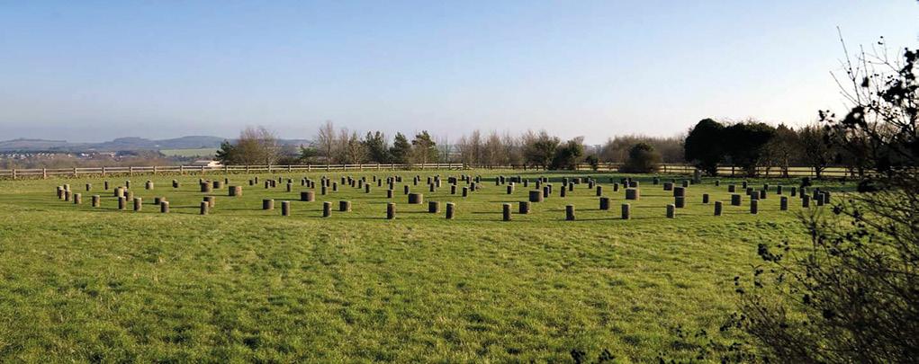
Woodhenge is a Neolithic henge made up of a timber circle monument from around 2500BC, made up of six concentric rings of timber, a surrounding bank and ditch which are all common features of henge monuments. The monument also had a single entrance to the northeast and, later in the construction of the site, at least two sarsen stones were added to the southern side of the monument.
The monument was discovered by aerial photography in 1925 and excavation began in 1926 which revealed the bank and ditch which had been filled in and concealed over time. Initially there was some debate as to whether it was an open-air structure, as Maud Cunnington, one of the leaders of the excavation, argued or that it was a communal building. However, after research at a similar site known as ‘The Sanctuary’ near Avebury, Woodhenge has been determined to have been an open structure.
The purpose of Woodhenge is unclear, however the remains of a young child and a teenager were found during excavations dating from between 1760 and 1670 BC. Previously these were thought to have been dedicatory sacrifices used as offerings when the site was first built, but further examination of the remains suggests that they were added to the monument much later during the Bronze Age. Unfortunately, however, more research into the origins of the remains of the child are impossible as the skeleton was lost in the Blitz. Other objects such as bones from domestic animals, cups and axes were discovered. The axes are speculated to have been buried in a deliberate pattern in certain areas in a form of symbolism known as ‘structured deposition’8. This suggests a ceremonial purpose or use as a burial ground.
How are the sites connected?
Before beginning to explore the connection between Stonehenge, Durrington Walls and Woodhenge, it is worthy to note that Stonehenge is the most famous of the sites being discussed and therefore is often the point of comparison and link between the sites. With this in mind, the first and most obvious connection there is between these sites are the many geographical similarities, which are highlighted by the fact the sites are all part of the Stonehenge Avenue and the same World Heritage site.
Physical similarities also play a key part in arguing for the connection between the monuments. Around the same time the sarsen stones were erected in the second period of building Stonehenge, two sets of concentric timber circles were built within a large settlement two miles northeast of the monument. One of these circles, called the ‘Southern Circle’, was at the centre of an ancient settlement. By 2460 BC the ruins were enclosed by the bank and ditch of Durrington Walls. Outside of the south entrance of the same settlement a third concentric timber circle was built, now known as Woodhenge. This parallel between the sites in terms of structure strongly suggests a connection exists.
At Durrington Walls the avenue was built in roughly 2500 BC between the ‘Southern Circle’ of the site and the River Avon and closely resembles the one from the third stage of Stonehenge’s construction, reinforcing the idea that the sites are linked. The discovery of this road also meant that there was a possibility that Durrington Walls was part of a larger Neolithic complex that was linked to Stonehenge and Woodhenge as both were connected to the river by roads as well. The multitude of physical similarities between Stonehenge and Woodhenge was also a key factor in the naming of the site as Woodhenge9. The lone entrance of the site also faces Durrington Walls, further proving the sites’ connection.
The sites of Stonehenge, Durrington Walls and Woodhenge are linked in another way too. One of the circles at Durrington Walls, called the ‘Southern Circle’, was at the centre of an ancient settlement. This was a short-lived community but is thought to have been the camp of the builders of Stonehenge, providing yet another link between the two sites. Similarly, although origins of Woodhenge remain unknown, many historians believe it was built by the same group that built Stonehenge too10
However, more obscure links also exist. All three sites have focuses on solstitial alignments. The Durrington Walls avenue was aligned toward the summer solstice sunset, while the ‘Southern Circle’ faced the winter solstice sunrise which was the opposite to the road at Stonehenge, emphasising the parallels between the sites. This alignment based on the main solstices therefore emphasises the possibility of Stonehenge and Durrington Walls being built as parts of a single complex based around the Avon. Stonehenge and Woodhenge also share the same alignments to the summer and winter solstices as both contain either timber or stones in an oval that face in those directions. These similarities suggest all three sites had spiritual or ceremonial importance and may have been used together in processional routes or ritual ceremonies.
Currently many of these theories rely on much speculation and educated hypothesis. However, these monuments are still being explored and being further investigated, which in time may reveal more connections to each other, as well as to other sites along the Stonehenge Avenue or possibly the rest of the country (which there is some rationale for due to the similar styles of settlement that exist in the Orkney Islands in Scotland). Although, for now the main links between these Neolithic wonders is their unique focus on solstitial alignments and the closeness of their locations.
1 Naomi Blumberg, Durrington Walls (Britannica) https://www.britannica.com/topic/Durrington-Walls
² History of Stonehenge (English Heritage) https://www.english-heritage.org.uk/visit/places/stonehenge/history-and-stories/history/
³ Stonehenge – First Stage: 3000-2935 BCE (Britannica) https://www.britannica.com/topic/Stonehenge/First-stage-3000-2935-bce
⁴ Stonehenge (History.com) https://www.history.com/topics/british-history/stonehenge
⁵ Naomi Blumberg, Durrington Walls (Britannica) https://www.britannica.com/topic/Durrington-Walls
⁶ Carly Hilts, Rethinking Durrington Walls: a long-lost monument revealed (Current Archaeology) https://archaeology.co.uk/articles/features/ rethinking-durrington-walls-a-long-lost-monument-revealed.htm
⁷ Durrington Walls (Wikipedia) https://en.wikipedia.org/wiki/Durrington_Walls
⁸ Woodhenge (stone-circles.org.uk) http://www.stone-circles.org.uk/stone/woodhenge.htm
⁹ The History of Woodhenge (English Heritage) https://www.english-heritage.org.uk/visit/places/woodhenge/history/
10 Evan Evans, You’ve heard of Stonehenge, but what’s Woodhenge? (Evan Evans) https://evanevanstours.com/blog/youve-heard-of-stonehenge-butwhats-woodhenge/
