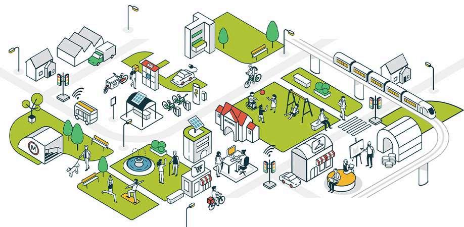
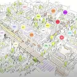
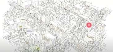
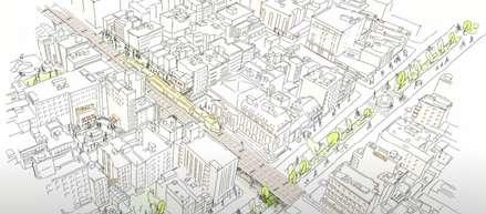
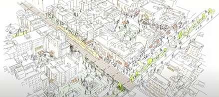
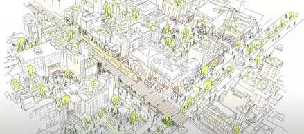
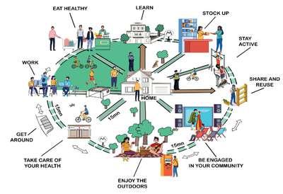
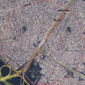
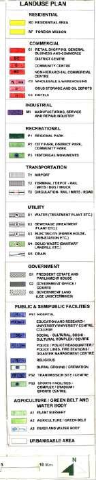
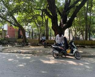
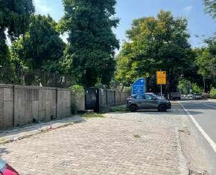
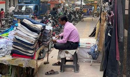
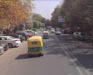
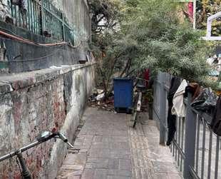
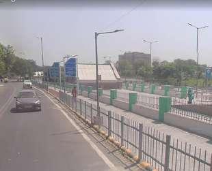
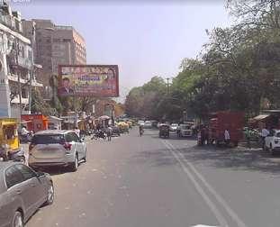
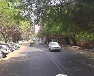
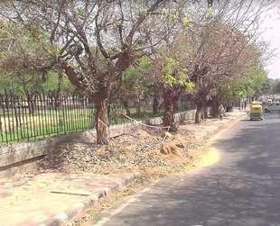
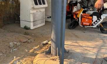
15-Minute City: An urban planning concept where all essential services and amenities (work, shopping, healthcare, education, and leisure) are accessible within a 15-minute walk or bike ride from one’s residence.
Walkability: The measure of how friendly an area is to walking, based on factors such as the presence of pedestrian infrastructure, safety, comfort, and proximity to amenities
Mixed-Use Development: Urban planning model where residential, commercial, institutional, and recreational spaces coexist within a compact area, encouraging a reduction in travel time and enhancing community interaction
Density: The number of people living or working in a given area, often measured in units such as people per square kilometer or building floor area ratio (FAR), impacting the urban design and walkability of a city
Transit-Oriented Development (TOD): A type of urban development that maximizes the residential, business, and leisure space around public transportation hubs like metro stations, fostering a walkable, sustainable environment.
Last-Mile Connectivity: The challenge of getting people from a transit hub (such as a metro station) to their final destination, typically within a walkable distance or via local transport solutions.
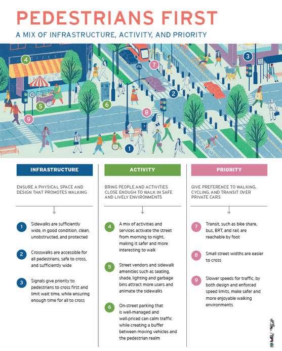
Pedestrian Infrastructure: Refers to sidewalks, crosswalks, traffic signals, and public spaces designed to ensure safe and comfortable movement for pedestrians.
What is a 15-minute city?
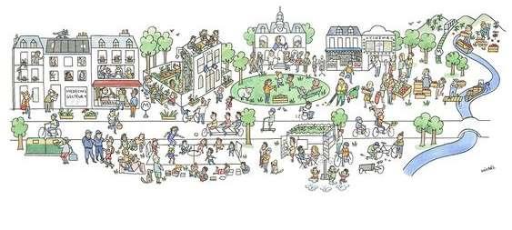
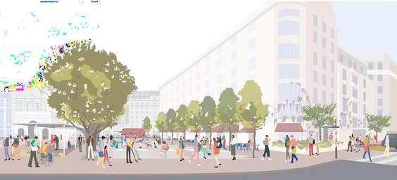
As the name suggests, a 15-minute city is an urban planning concept where everything a resident needs can be accessed within a 15-minute journey Rather than making an entire city traversable in 15-minutes, it instead means designing local areas to have everything civilians need within this distance
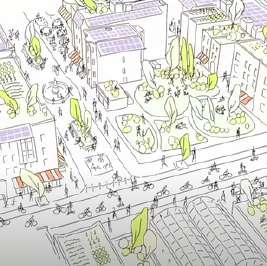
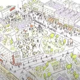
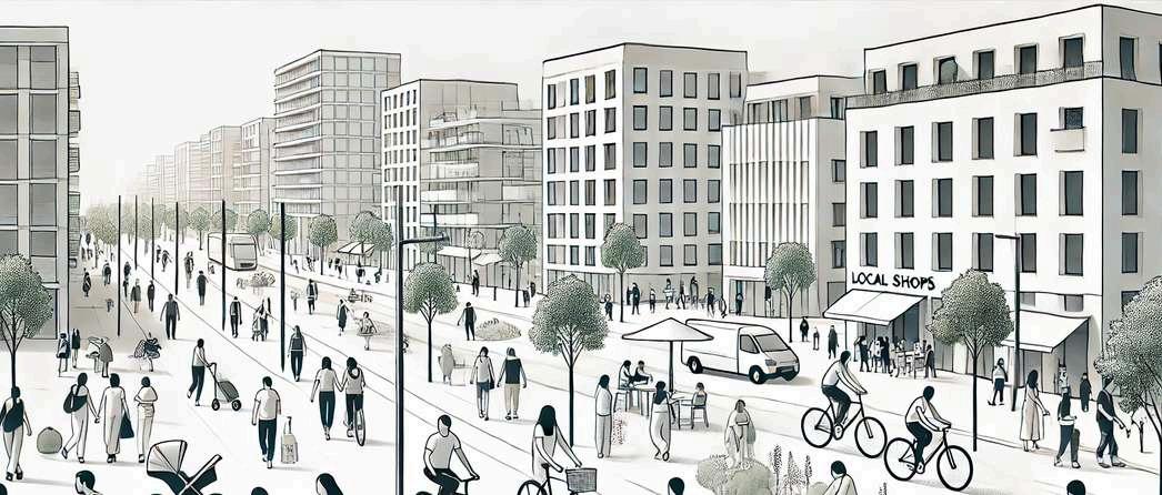
The intention of this human-centric design concept is to reduce the use of cars and instead promote walking, cycling, and use of public transport As such, 15-minute cities tend to emphasize features like green and public spaces, bike lanes and public walkways rather than roads
Carlos Moreno, a French-Columbian scientist and university professor at the Sorbonne, and one of the chief proponents of the “15-minute city” concept as adopted by Mayor Anne Hidalgo of Paris describes the 15-minute city as encompassing three basic principles: Build cities around people, not cars. 1
Where does the 15-minute concept come from?
The 15-minute model was revived in 2016 by scientist and business professor Carlos Moreno and gained significant traction in the wake of the COVID-19 pandemic and and is now being embraced by urban planners globally.
The concept builds on earlier urban planning ideas like Ebenezer Howard’s Garden Cities of To-morrow (1902) and Clarence Perry’s 1920s neighborhood unit, designed to create selfcontained communities.
“The golden rule of the 15-minute city is that “every square meter that is already built should be used for different things ”
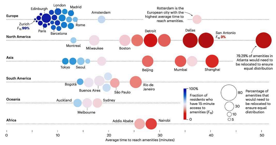
The fraction of residents who have 15minute access to essential services in a city is closely related to the average time it takes to reach these points, suggesting that cities with poor average accessibility are also those with the highest inequality
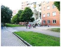
In more recent times, the Town of Poundbury in Dorset (pictured above), built in 1994 and championed by King Charles III, can be seen as an early incarnation of a 15-minute neighborhood, with its design intended to allow easy, local access to amenities and facilities.
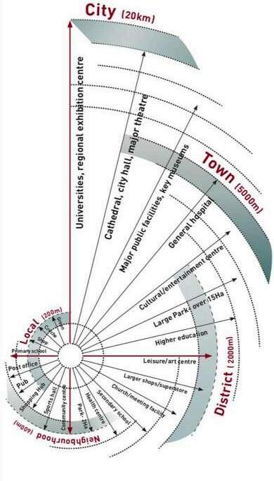
This was supported through new urbanism ideas such as the compact city, and by many of the recommendations arising from ‘Towards an Urban Renaissance’ led by Sir Richard Rogers in 1999, which included Andrew Wright Associates bespoke ‘From Neighborhood to City’ diagram Moreno expanded his model in 2021, identifying six key functions residents should access within 15 minutes
“The 15-minute city idea answers the question of saving time by turning it on its head by suggesting a different pace of life a 15minute pace ”
The applicability of 15-minute city in Indian context
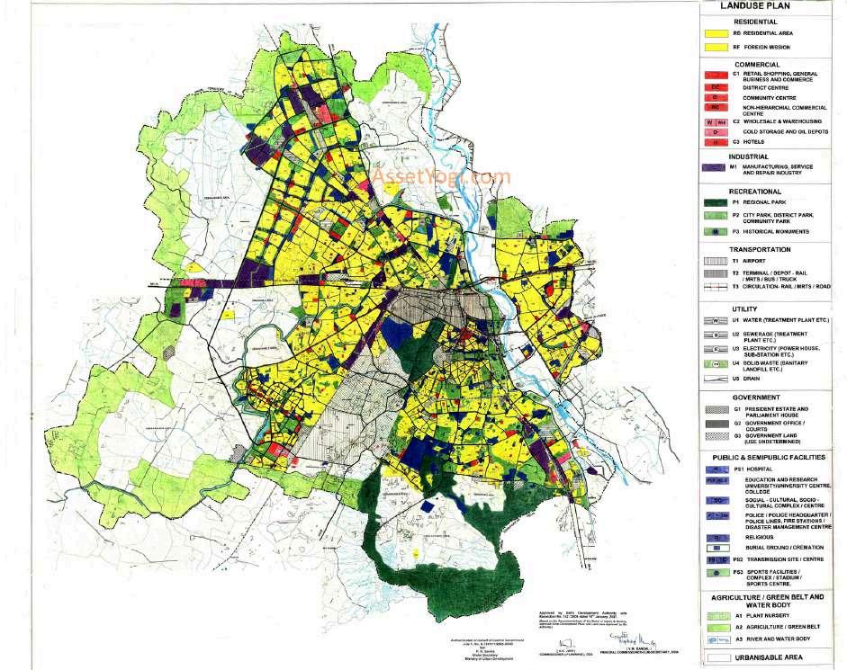
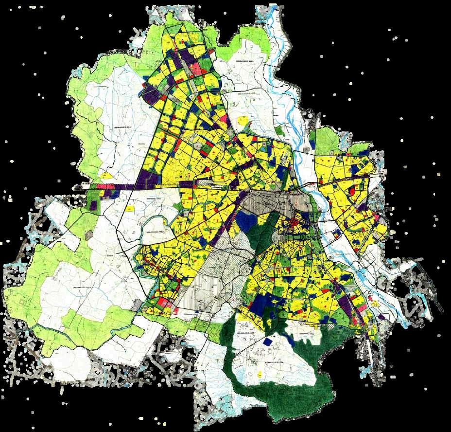
The 15-minute city concept isn't new to Indian planning practices The Delhi Master Plan and cities like Mumbai and Bengaluru already use population- and area-based norms for amenities like health, education, and commerce, which, in dense areas, are often accessible within a 15-minute timeframe High densities could even lead to smaller, more accessible neighborhoods, such as seven-minute cities
Reduced reliance on work centres due to 15-minute neighborhoods
Unlike the 15-minute city, which focuses on proximity, Indian norms consider both distance and the capacity of amenities to serve local populations Indian cities often have polycentric structures with primary and secondary work centers, necessitating mobility for economic growth, as outlined by urban planner Alain Bertaud. This structure contrasts with the 15minute city's reliance on workfrom-home, which isn’t feasible for most of India’s workforce due to the prevalence of informal employment and low digital access.
To promote livable neighborhoods, India must decentralize lower-order services locally while maintaining higher-order services at a citywide scale Redevelopment and compact city planning, supported by public and non-motorized transport, could help realize the 15-minute city concept, though implementation relies on local area plans and policy support
What we aim to do:
To evaluate and compare the walkability of three distinct urban neighborhoods in Delhi INA, Vasant Kunj, and Laxmi Nagar within the framework of the 15-minute city concept, with a focus on urban density, accessibility to essential services, and the role of public transit in shaping walkable environments.
Towards a 15-minute city:
A Network-Based Evaluation Framework
Published in: Environment and Planning B: Urban Analytics and City Science, 2022
Authors: Shanqi Zhang, Feng Zhen, Yu Kong, Lobsang Tashi, and Sicong Zou
DOI: 10.1177/23998083221118570
Introduction
The concept of the "15-minute city" proposes that all essential services should be accessible within a 15minute walk or bike ride from residents' homes. This urban planning approach, originally popularized in cities like Portland and Paris, aims to reduce dependency on cars, lower carbon emissions, and promote equitable access to amenities The COVID-19 pandemic highlighted the importance of this model in ensuring urban resilience and reducing inequalities in service access.
Objective
The study introduces a network-based framework to assess 15-minute cities by evaluating the alignment between human mobility patterns and the distribution of urban amenities. Traditional methods assess accessibility but often fail to consider real-world human behavior and mobility patterns, which this study aims to address.
Methodology
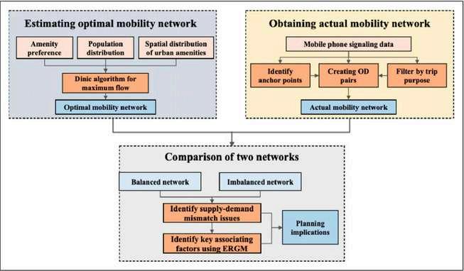
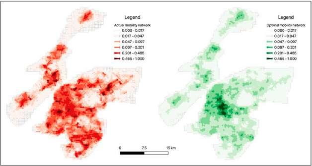
The evaluation framework compares the optimal mobility network, modeled using spatial distribution and population data, with the actual mobility network, derived from mobile phone signaling data.
The study was conducted in Nanjing, China, using a 500-meter grid for analysis The comparison reveals discrepancies (mismatches) between the two networks, identifying areas where the provision of services does not match the actual needs of the population
Key findings
Discrepancies in Mobility
Patterns: The actual mobility network showed uneven travel patterns, with certain areas, like CBDs and sub-cities, experiencing higherthan-expected traffic, indicating residents had to travel further to meet their needs.
Proposed network-based framework for evaluating 15-minute city
Spatial distributions of actual and optimal mobility networks
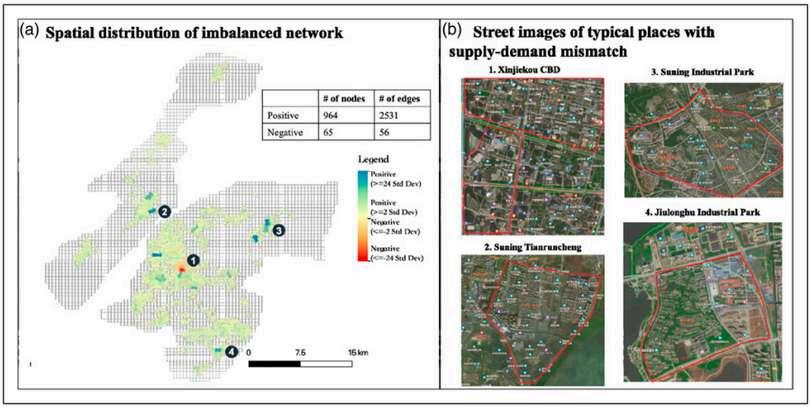
Supply-Demand Mismatch: Central business districts saw an oversupply of high-end services that didn't meet local residents' daily needs, while newer sub-cities lacked sufficient amenities, leading to longer trips for basic services.
Demographic Impact: Areas with a high senior population had fewer imbalances, as their travel patterns were more localized compared to younger, more mobile populations.
(a) Spatial distributions and descriptive statistics of imbalanced network and (b) street images of typical places with supply-demand mismatch.
Factors Contributing to Mismatches
Diversity and Density of Amenities: Imbalances were more likely to occur in areas with a low diversity of amenities and lower road density, where residents had fewer options for services within walking distance. In contrast, areas with high point of interest (POI) density and diverse services tended to better meet residents' needs.
New Development Zones: Newly developed areas, such as industrial parks and university towns in the sub-cities, were identified as zones with high discrepancies. These areas, while newly populated, often lacked adequate services to cater to the specific needs of the workforce or residents, resulting in frequent trips outside the immediate area.
Planning Implications
The findings suggest that Nanjing's efforts toward a 15-minute city are hindered by a mismatch between the provision of services and the actual needs of the population. CBDs and new sub-cities face challenges in balancing supply and demand, particularly as they continue to grow and attract more residents The study recommends more targeted planning interventions, focusing on optimizing service provision and aligning urban amenities with the real-world mobility patterns of different demographic groups.
Overall, the study highlights the importance of dynamic urban planning, using real-time mobility data to continually assess and adjust the distribution of services to create more balanced, accessible urban environments.
The 15-minute city:
Interpreting the Model to Bring Out Urban Resiliencies
Published in: Transportation Research Procedia, 2022
Authors: Lamia Abdelfattah, Diego Deponte, Giovanna Fossa
DOI: 10.1016/j.trpro.2021.12.043
Introduction
The paper, The 15-Minute City: Interpreting the Model to Bring Out Urban Resiliencies, discusses the potential of the 15-minute city (FMC) model in fostering sustainable urban planning and resilience. The FMC concept emphasizes the need for essential services and amenities to be within a 15-minute walk or bike ride from residents’ homes, reducing car dependence and improving community well-being The study applies the FMC model to Milan, Italy, evaluating how walkability and proximity to services can create more livable urban environments.
Concept
The 15-minute city (FMC) is based on the principle of chrono-centric urban design, focusing on reducing the time residents spend commuting by ensuring local access to essential services. It prioritizes walkability, community, and place identity, encouraging less reliance on motorized transportation This model has gained traction, especially during the COVID-19 pandemic, as soft mobility options like walking and cycling enabled social interactions while maintaining health protocols.
The paper contrasts the FMC model with the Transit-Oriented Development (TOD) approach, which focuses on high-density development around public transport hubs. The authors argue that FMC provides a more resilient alternative, particularly post-pandemic, by promoting decentralized urban living.
Case study: Milan
To assess Milan’s potential as a 15-minute city, the study performs a three-step analysis:
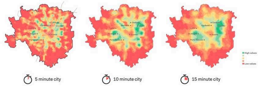
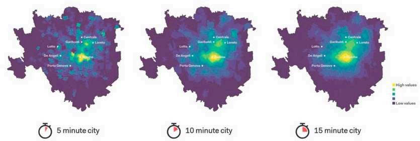
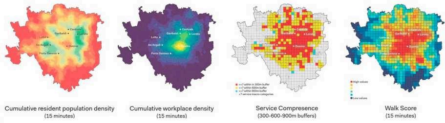
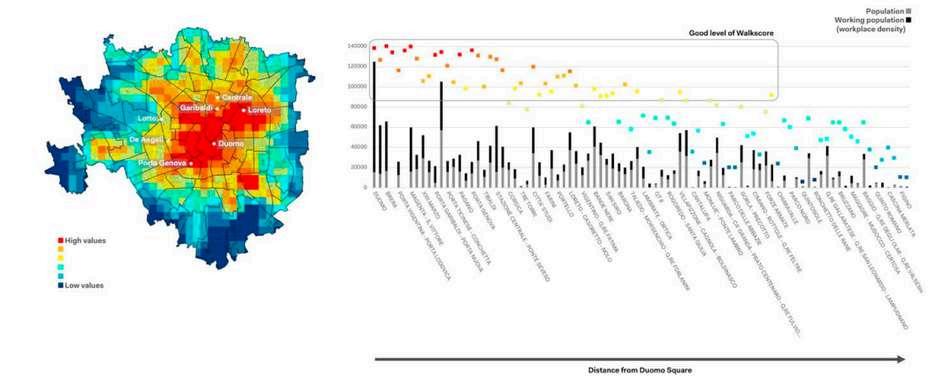
Population and workplace density: Mapping where residents and workers live and their ability to access services within a 15-minute walking distance.
Service proximity analysis: Evaluating the distribution of essential services such as food, healthcare, education, and public spaces.
Walkability (Walk Score): Measuring the overall walkability based on road infrastructure and proximity to key services.
Different analytical components of the
Walk Score and 15-minute population accessibility by NIL neighborhoods
Findings
Central Areas: Neighborhoods like Duomo and Porta Garibaldi have high walkability and easy access to services.
Peripheral Areas: Outer districts face challenges in pedestrian access despite high population density. Service Distribution: Central areas are well-served, while some peripheral areas exceed the 15-minute walking limit, resulting in uneven walkability
Conclusion
The 15-minute city model offers a transformative framework for Milan, promoting sustainability and equity through enhanced walkability and improved access to essential services.
15-minute city model
Pedestrian access of the working population to different census sections of the city in 5/10/15 minutes
Walkability as an Urban Design Problem:
Understanding the Activity of Walking in the Urban Environment
Published in: KTH Royal Institute of Technology Architecture and the Built Environment School of Architecture SE-100 44 Stockholm Sweden, 2012
Authors: Eunyoung Choi
ISSN: 1402-7453
Introduction
It focuses on exploring the relationship between the built environment and walking behavior It addresses the increasing importance of pedestrian-friendly urban environments, citing public health, sustainability, and social benefits. The research highlights gaps in the existing walkability studies, which often lack empirical evidence and fail to guide urban design practice effectively
Objective
The primary objective of the study is to refine the methods used to analyze the correlation between walking behavior and the physical environment. The goal is to understand how and why different aspects of the built environment influence walking behavior.
Methodology
The study follows a mixed-method approach that includes literature review and an empirical investigation. The empirical part of the study focuses on three residential areas in Stockholm: SoFo, Södra Station, and Hökarängen.
The study employs observation methods to track pedestrian density, route choices, and walking behaviors in these areas. Data was collected by observing pedestrians’ movements and activities over different times, days, and seasons.
Empirical Study
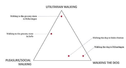
The study involved tracking walking activities, observing pedestrian density, and assessing the walking conditions of each area The research sought to identify how built environment factors like land use, connectivity, and spatial configuration influence walking. A key aspect of the study was partitioning walking activities based on their purpose, such as walking to public transit or walking for recreation.
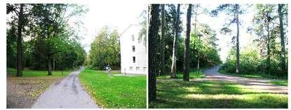
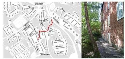
These pedestrian paths are rather distinctive in that they are designed to cut through the green areas
The car-free situation creates a safe walking environment for children, and during daytime
They are surrounded almost only by greenery, and seldom by buildings, creates a rather monotonous environment on the other hand
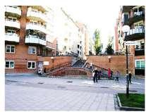
Together with the connected park area, the wide street is occasionally used as space for their play and recreation as well.
Key findings
The empirical results confirm the significance of factors such as land-use diversity, connectivity, and density, commonly identified in walkability research However, the study emphasizes that different walking activities are influenced by varying conditions of the environment. For instance, utilitarian walking (e g , commuting) and recreational walking are affected differently by the built environment. The study also found that environmental conditions significantly shape pedestrian behavior, influencing both the presence and characteristics of walking activities in different areas
Conclusion
Choi’s research provides valuable insights into how urban design influences walking behavior. The findings suggest that urban design plays a crucial role in shaping pedestrian activities and that different types of walking should be considered in urban planning The study calls for refining walkability metrics and developing more specific, evidence-based urban design guidelines to promote walking as a sustainable and healthy activity
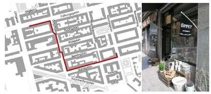
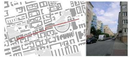
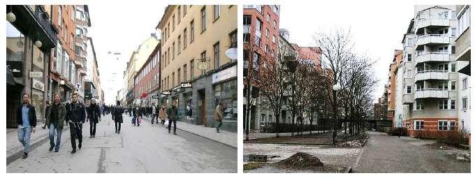
Photographs of Götgatan and Södermalmsallén on the same day (weekend afternoon)
Different walking activities
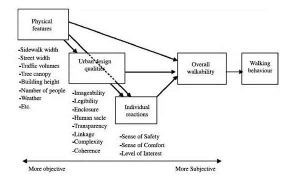
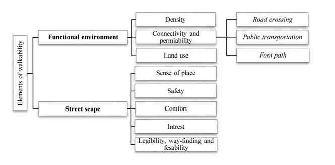
Conceptual framework for the influence on walking behavior (Ewing & Handy, 2009)
City Sustainability:
The Influence of Walkability on Built Environments
Published in: Transportation Research Procedia, 3rd CSUM 2016, Vol 24, 2017, pp 97-104
Authors: Reihaneh Rafiemanzelat, Maryam Imani Emadi, Aida Jalal Kamali
DOI: https://doi org/10 1016/j trpro 2017 05 074
Introduction
It explores how walkability significantly contributes to sustainable urban environments
Walkability, defined as the ease with which people can walk around an area, plays a pivotal role in promoting community involvement, reducing greenhouse gas emissions, and improving public health.
Objective
The objective of the research is to examine the relationship between walkability and the built environment and how it impacts city sustainability Specifically, the study aims to assess how urban design features influence walking behavior and determine the environmental and social benefits of walkability in promoting a sustainable urban ecosystem.
Methodology
The study employs a multidisciplinary approach, combining insights from urban design, architecture, public health, and transportation. A detailed literature review forms the foundation of the research, focusing on how walkability correlates with factors such as density, design, diversity, destination accessibility, and distance to transit ("The Five Ds").
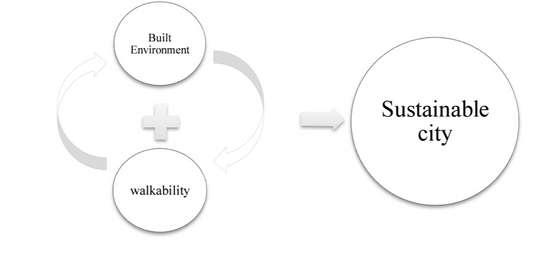
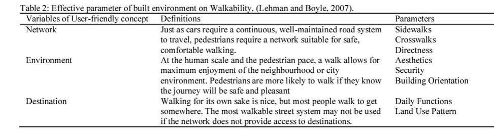
Correlated elements of walkability and built environment (Fitzsimons, 2013)
The relationship between walkability and built environment
Walkability Problem in Indian Cities:
An Investigation
Published in: Safer Communities, Vol 16, Issue 2, 2017
Authors: Jehangir Pheroze Bharucha
ISSN: 1757-8043
Introduction
This research, conducted by Jehangir Bharucha, investigates the walkability issues in Indian cities, with a specific focus on Mumbai. Walkability is crucial for the development of sustainable cities, improving health, reducing congestion, and enhancing social interactions. Despite these benefits, Indian cities face significant challenges, such as poorly maintained sidewalks and safety concerns, making walking a difficult and dangerous task
Objective
The primary objective of this study is to assess the walkability of Mumbai and identify the challenges faced by pedestrians. It aims to provide policy recommendations to improve pedestrian infrastructure and enhance the walkability of urban spaces
Methodology
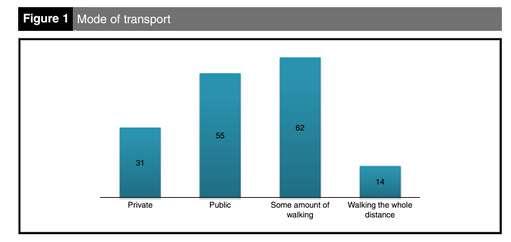
The study utilizes a mixed-method approach, combining surveys and field observations Five districts in Mumbai were selected for analysis: commercial, transport terminal, educational, and two residential areas. A structured questionnaire was administered to 100 pedestrians from the middle and lower-middle classes, focusing on their walking difficulties and potential solutions. In addition, the researcher and a group of students walked the routes to collect more specific information about the challenges faced
Conclusions
Mumbai’s walkability is severely compromised by poor infrastructure, safety concerns, and a lack of space for pedestrians Immediate action is needed to address these issues and make the city more pedestrian-friendly The study emphasizes that a shift in focus towards pedestrian safety, infrastructure improvements, and better law enforcement is necessary to create walkable cities in India.
Key Findings
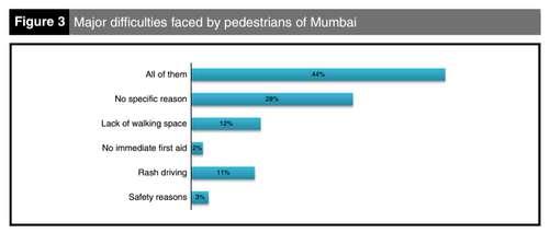
The research highlighted several critical issues affecting walkability in Mumbai:
Lack of Infrastructure: Many areas lack sidewalks, zebra crossings, and subways, forcing pedestrians onto streets, which increases the risk of accidents
Safety Concerns: Rash driving, eve teasing, and unsafe conditions for women and children discourage walking, particularly at night.
Congestion and Pollution: High vehicle congestion, poor air quality, and vendors occupying sidewalks reduce walking space and make walking unpleasant.
Neglected Pedestrian Rights: Poor law enforcement and traffic management make walking hazardous, with pedestrians often ignoring traffic rules and drivers showing little consideration for walkers.
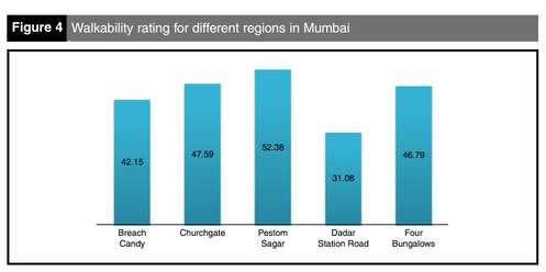
The walkability ratings for the five areas revealed poor conditions, with an average score of 43.98 out of 100 The highest rating was 52.38, while Dadar Station Road, one of the busiest roads, had the lowest rating of 31.08
Recommendations
Government: Construct more sidewalks, subways, and zebra crossings; enforce stricter penalties for traffic violations; and improve road maintenance.
Pedestrians: Follow traffic rules and make use of existing pedestrian facilities such as zebra crossings and footpaths.
Vehicle Owners: Avoid rash driving and prioritize pedestrian safety.
Impacts of Walkable Communities:
On Resident’s Physical & Social Health
Published in: Design & Health Scientific Review, July 2013
Authors: Xuemei Zhu, Zhipeng Lu, Chia Yuan Yu, Chanam Lee, George Mann
PMID: 35069078
Introduction
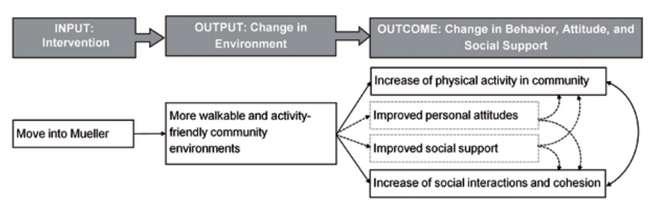
Auto-oriented cities contribute to sedentary lifestyles and social isolation In response, urban planning models like New Urbanism advocate for walkable communities that enhance physical activity and social cohesion. This report explores how Mueller, a LEED-ND certified walkable community in Austin, Texas, impacts residents' physical and social health
Objective
- Assess the effect of walkable environments on residents' physical activity
- Evaluate social interactions and community cohesion in walkable communities.
- Explore environmental and economic benefits of reduced car dependency.
Methodology
- Focus Groups: 13 residents discussed physical activity and social interactions before and after moving to Mueller.
- Online Survey: 148 responses measured changes in physical and social health, and car usage. Statistical analysis (t-tests, correlation) evaluated differences pre- and post-move.
Conceptual framework for the mechanisms through which environmental changes in uence physical activities and social interactions and cohesion
Study Setting
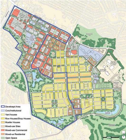
Mueller Community Mueller is a mixed-use, pedestrian-friendly development near downtown Austin It promotes walking and outdoor activities with parks, connected streets, and accessible amenities.
Mueller is the first exemplary project in Austin to use a series of innovative policies to create a model for walkable, sustainable and equitable communities. It includes many activityfriendly design features, such as high density, mixed-land uses, well connected street networks with sidewalks, and rich and diverse natural resources and open spaces distributed throughout the community.
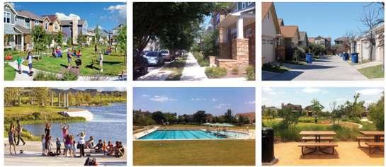
Environmental features supportive of physical and social activities, such as sidewalks, parks and open spaces, bike routes, diverse destinations, communal facilities, front porches and back alleys shared by small groups
Conclusions
Walkable communities like Mueller foster higher physical activity, greater social interaction, and environmental benefits. Urban planners should prioritize walkable designs to create healthier, more sustainable cities.
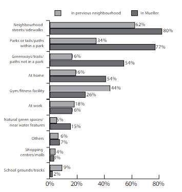
Percentage of respondents reporting certain locations of physical activity before and after the move
Land use map and developed areas of Mueller community (Source: Catellus)
The Concept of a Walkable
City: As an Alternative Form of Urban Mobility
Published in: Scientific Journal of Silesian University of Technology. Series Transport, 2017
Authors: Katarzyna TUROŃ, Piotr CZECH, Michał JUZEK
DOI: https://doi.org/10.20858/sjsutst.2017.95.20
Introduction
Urban mobility has long been centered on automobile traffic, leading to numerous issues such as traffic congestion, pollution, and restricted pedestrian spaces The concept of a walkable city has emerged as an alternative approach to urban mobility, focusing on creating pedestrian-friendly environments. This report analyzes the concept of walkability, particularly in the context of Polish cities, as an integral part of sustainable development and urban logistics.
Objective
The objective of the study is to explore walkability as a form of smart mobility that enhances urban spaces, supports sustainable transport, and promotes pedestrian-friendly solutions The report outlines specific walkability solutions implemented in several Polish cities and discusses their effects on urban life and logistics.
Methodology
The report employs a qualitative analysis of walkability solutions implemented in cities such as Łódź, Rybnik, Szczecin, Gdynia, Wrocław, and Katowice. The study examines these solutions in terms of their contribution to pedestrian mobility, environmental benefits, and urban space optimization. It also utilizes the "Walk Score" indicator to assess the effectiveness of these solutions, measuring various factors such as safety, convenience, and access to amenities.
Key findings
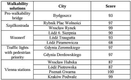
The Walk Score indicator value for Polish pro-pedestrian solutions (Source: authors’ own work )
To create a truly walkable city, urban planners focus on four primary conditions: security, functionality, attractiveness, and convenience. Key benefits of walkability include:
Enhanced safety for pedestrians
Reduced pollution and noise
Support for local businesses and tourism
Improved health and quality of life for residents
Result
The analysis shows that implementing walkability solutions in Polish cities significantly improves urban mobility and enhances the quality of life for residents The Walk Score results demonstrate that cities adopting pro-pedestrian practices are more walkable, with scores ranging from 68 to 100, depending on the specific solution and location.
Proximity-Based Planning and the "15-Minute City":
A Sustainable Model for the City of the Future
Published in: The Palgrave Handbook of Global Sustainability, Berlin, Germany, 2023
Authors: Zaheer Allam, Carlos Moreno, Didier Chabaud, Florent Pratlong
Urban environments have undergone significant changes due to factors such as population growth, technological advances, and economic development. One of the latest urban planning models, the "15-Minute City," emphasizes proximity-based planning, which seeks to provide urban residents with access to all essential services within a 15-minute walk or bike ride. The COVID-19 pandemic has highlighted the need for urban models that prioritize sustainability, accessibility, and community interaction, aligning with global sustainability goals such as the Paris Agreement and the United Nations Sustainable Development Goals (SDG 11)
Objective
To explore the 15-Minute City concept as a sustainable alternative to traditional urban planning, offering a solution to challenges like traffic congestion, environmental degradation, and urban discontent. It evaluates how proximity-based planning can enhance the livability of cities, reduce emissions, and promote healthier lifestyles.
Methodology
Key findings
1
4. This chapter reviews the principles of proximitybased planning and its practical applications in urban settings. By analyzing case studies from cities like Paris, the research assesses how the 15-Minute City model can transform existing urban infrastructures to meet sustainability and social well-being objectives. The authors utilize interdisciplinary perspectives, combining urban planning, sustainability studies, and the impact of technology on urban design.
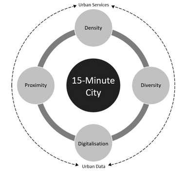
The 15-Minute City concept is built on four fundamental principles: Proximity: Ensuring that residents can access essential services (e g , healthcare, education, shopping) within a 15-minute walk or bike ride.
3.
2. Diversity: Promoting mixed-use neighborhoods that accommodate residential, commercial, educational, and recreational functions
Density: Achieving an optimal population density that supports local services without overwhelming infrastructure.
Ubiquity (Digitalization): Leveraging technology to enhance urban living by integrating smart city technologies that improve accessibility and resource management.
The 15-Minute City Model (Moreno et al. 2021)
Findings
The research finds that proximity-based urban planning, as exemplified by the 15-Minute City, offers numerous benefits.
These include:
Reduction in carbon emissions by minimizing reliance on cars and promoting soft mobility options such as walking and cycling.
Improved social interactions by fostering closer-knit communities that enable stronger social ties and increased local economic activity.
Healthier urban environments due to the reduction in pollution and the promotion of active transportation
Resilience in post-COVID cities, as the model facilitates local accessibility and reduces the need for long-distance travel during pandemics or crises.
The chapter also identifies several cities, including Paris and Bogotá, that have implemented or piloted proximity-based planning, demonstrating its viability as a scalable urban model.
Conclusions
The 15-Minute City offers a sustainable framework for future urban development, prioritizing accessibility, sustainability, and community engagement. By addressing environmental and social challenges, this model aligns with global sustainability agendas and promotes a more livable urban experience. Retroactively applying the 15-Minute City concept to existing urban structures will require policy reform, investment in infrastructure, and widespread adoption of digital technologies to achieve its full potential.
Results
To effectively transition toward the 15-Minute City model, urban planners and policymakers must: Encourage mixed-use developments.
Invest in digital technologies that support real-time urban management
Collaborate with local communities to ensure the model meets the needs of diverse populations.
1.
Towards a 15-minute city
2. The 15minute city
The paper establishes a framework for assessing the 15-minute city concept. It focuses on accessibility, mixed land use, and sustainable transportation.
The study uses the 15minute city model to emphasize local access to essential services and promote sustainability and community wellbeing.
3. Walkability as an Urban Design Problem
4. The Influence of Walkability on Built Environmen-ts
Focuses on how walkability contributes to sustainable urban planning, emphasizing "The Five Ds" of urban design (density, diversity, etc.).
Examines the relationship between walking behavior and urban design, highlighting the impact of different street-level designs on pedestrian activity.
5. Walkability Problem in Indian Cities
6. Impacts of Walkable Communiti-es
Investigates the practical challenges of walkability in Mumbai, focusing on poor infrastructure, safety concerns, and congestion.
Walkable communities improve physical and social health by promoting active transportation and social interaction.
Evaluation methods include surveys and spatial analysis using GIS. Data collection assesses residents' access to services and physical activity levels.
It employs a three-step analysis: mapping population density, assessing service proximity, and calculating Walk Scores for walkability.
Uses case studies of walkable cities (e.g., Copenhagen) and a literature review to evaluate urban design features.
Employs empirical observation in Stockholm neighborhoods, analyzing pedestrian density and route choices.
Uses surveys and field observations in five districts of Mumbai, collecting data from 100 pedestrians on their walking experiences.
Metrics: Activity levels, health outcomes, social interactions.
Data: Surveys, health data, GIS.
The paper recommends mixed-use developments and pedestrian-friendly infrastructure. Effective zoning policies are crucial for creating walkable environments.
The authors recommend investing in pedestrian infrastructure, expanding micro-mobility options, and applying tactical urbanism to enhance walkability.
Advocates for integrating pedestrian infrastructure in urban planning to reduce car dependency and enhance connectivity.
Challenges include carcentric infrastructure and stakeholder resistance. Financial investments and equity concerns also limit implementation efforts.
Challenges include uneven service distribution, resistance to change, and the need for significant infrastructure investments.
Difficulty in shifting carcentric development models and a lack of reliable data on pedestrian behavior.
7. The Concept of a Walkable City
8. ProximityBased Planning and the "15Minute City"
The study centers on walkability, aiming to make cities more pedestrian-friendly as a sustainable mobility alternative, with examples from Polish cities like Łódź and Wrocław.
Proximity-based planning and the 15-minute city focus on creating walkable, sustainable, and equitable neighborhoods, where essential services are within 15 minutes by foot or bike.
Walkability is measured using the Walk Score, assessing factors like safety and convenience in various urban spaces.
Proposes evidence-based design principles to improve both city-level and streetlevel walkability.
Metrics: Accessibility, walkability, emissions, public health, and equity.
Data: GIS, mobility data, surveys.
Recommends building more sidewalks, subways, and safer crossings, with stricter enforcement of traffic laws.
Translating empirical findings into practical guidelines is challenging, as is measuring the impact of urban design.
Major challenges include poor infrastructure, limited pedestrian space, and deeply ingrained car culture, along with safety concerns.
Pedestrian infrastructure, mixed-use development, and green spaces
Equity, costs, space constraints, and behavioral resistance
Planning involves pedestrian-priority city designs, enhancing streets with wider sidewalks and reduced car traffic to improve walkability. Challenges include public resistance, lack of funding, and the piecemeal adoption of pedestrian solutions rather than comprehensive city-wide plans
Mixed-use development and zoning reforms. Prioritizing public transport and cycling infrastructure.
High infrastructure costs, resistance to change, equity concerns, and space constraints in dense areas.
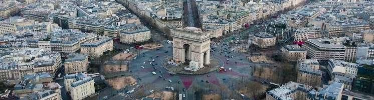
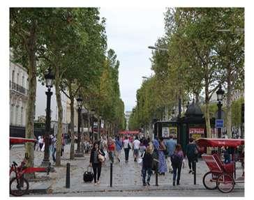
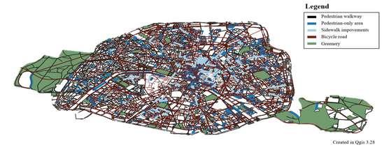
You can discover Paris’s history and culture in a quiet and traffic-free environment thanks to the city’s many pedestrianized areas! The capital has more and more of these areas prohibited to motorized vehicles, either all year round or at the weekend. One hundred or so streets, including the Rue Cler, Rue de Lévis, Rue de Lutèce, and Rue des Barres, are pedestrianized in Paris! Each arrondissement has some and it is a pleasure to stroll through them.
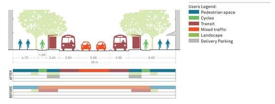
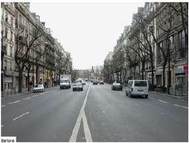
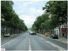
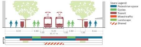
Sidewalk widened (from 4 m to 8 m) and lane narrowed. Crossing distance shortened from 20 m to 12.8 m
Separated cycle track Dedicated bus-only lane New trees planted along the sidewalk extension
Social Reforms
CAR FREE DAYS-
On the 1st Sunday of the month, the entire length of the famous Avenue des Champs-Elysées is given over to pedestrians
Every first Sunday of the month, pedestrians can also take advantage of the almost-total pedestrianization of the capital’s 1st, 2nd, 3rd and 4th arrondissements Finally, the crowning event of the year for fans of urban walks or a stroll with the family is the city’s Car Free Day On this occasion, Paris becomes a pedestrian village, where motorized vehicles are banned throughout the city.
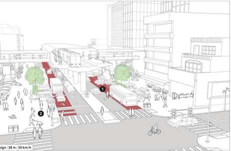
REDESIGNED-ROAD SECTION
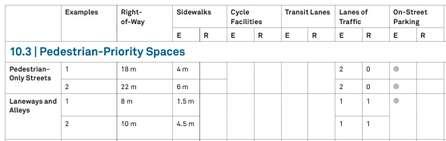
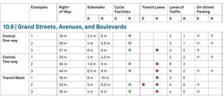
The street is redesigned to prioritize transit and shared mobility, improve walking conditions and public space, and transform key transfer nodes into recognizable landmarks.
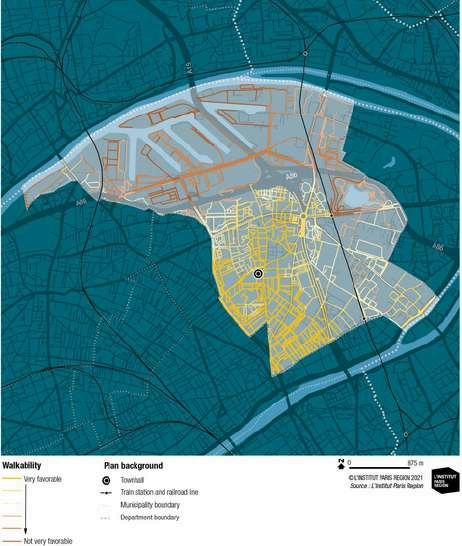
The commune’s walkability is influenced by its port and logistics activity, a cardependent northern neighborhood, and barriers from road and rail infrastructure. The city center around the town hall is more walkable due to businesses and facilities. The walkability index incorporates spatial data from SIGR6, considering factors like amenities, urban heat islands, and road characteristics.
Goals
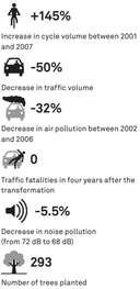
• Reduce traffic fatalities, congestion, and pollution.
• Create a more attractive and pedestrian-oriented environment.
• Create a space that supports businesses.
Budget Changes
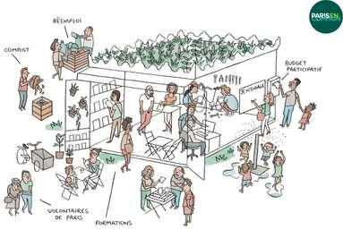
Paris has found large and small ways to push its roads towards a people-focused future According to Paris’ participatory budget an initiative that allows citizens to suggest and vote on how the city should spend a portion of its budget each year a number of pedestrian-focused projects were relatively economical. Installing benches and painting games for children on a car-free street, for example, cost € 20,000 ($22,600).
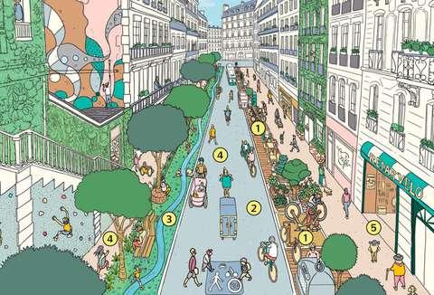
Share the streets
Becoming pedestrian friendly isn’t just about getting rid of cars. In many cities, current sidewalk widths aren’t sufficient to safely accommodate more pedestrians, especially now that people need space not just for walking, but also for queueing outside stores Before the pandemic, Paris was expanding pedestrian space in mixed-use zones Large-scale initiatives redeveloped seven of the city’s famous squares some designed by Haussmann himself, such as Place de la Madeleine and Place de la Bastille to give more room to walkers, cyclists, and tourists
After Covid-19 hit, the city ramped up plans to separate citizens by redeveloping space around transportation stations and major shopping streets, as well as some schools and public facilities
Dedicate public space to communities
Reforming streets and sidewalks to favor pedestrians is also about creating lively, vibrant communities and neighborhoods. Paris has done this by developing “children’s streets” roads normally open to vehicles but closed periodically for children to enjoy. Temporary barriers are placed to block traffic, volunteers arrive, games are provided, and paintings on the pavement encourage play.
Paris Council adopted the Paris Pedestrian Strategy unanimously in January 2017. The plan aimed to give walking more priority as an efficient and sustainable mode of transport after recognising that more than half of Paris’ public space is dedicated to private motorised vehicles, but only 13% of urban trips by Parisians are made by car.
Paris, France Wide sidewalks provide space for promenading and people watching
• Facilitate pedestrian continuity and shared streets between different modes
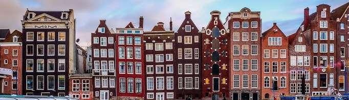
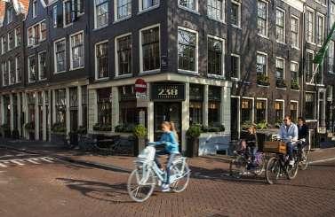
Amsterdam, renowned for its sustainable urban planning, exemplifies a walkable city that prioritizes pedestrian accessibility Known for its compact, cyclist-friendly layout and a comprehensive public transport network, Amsterdam has emerged as a model for urban walkability By integrating public spaces, minimizing car dependency, and fostering a sense of community, Amsterdam provides a framework for cities seeking to enhance pedestrian experience and environmental sustainability
Urban Layout and Walkability Design
The urban design of Amsterdam encourages walking through a mix of compact street layouts, pedestrian paths, and dedicated cycling lanes The city’s core emphasizes mixed-use zoning, ensuring that essential services, recreational spaces, and green areas are within a short walking distance for residents This intentional planning creates interconnected neighborhoods, or "urban villages," that support the concept of walkable living.
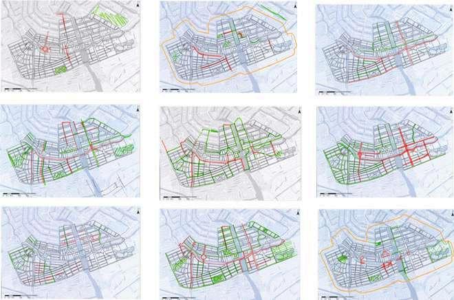
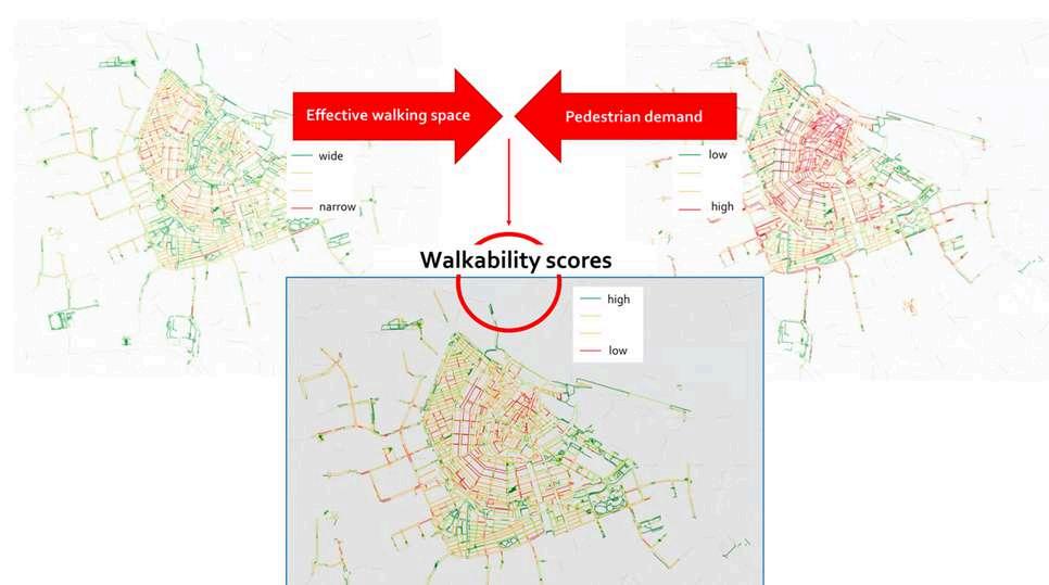
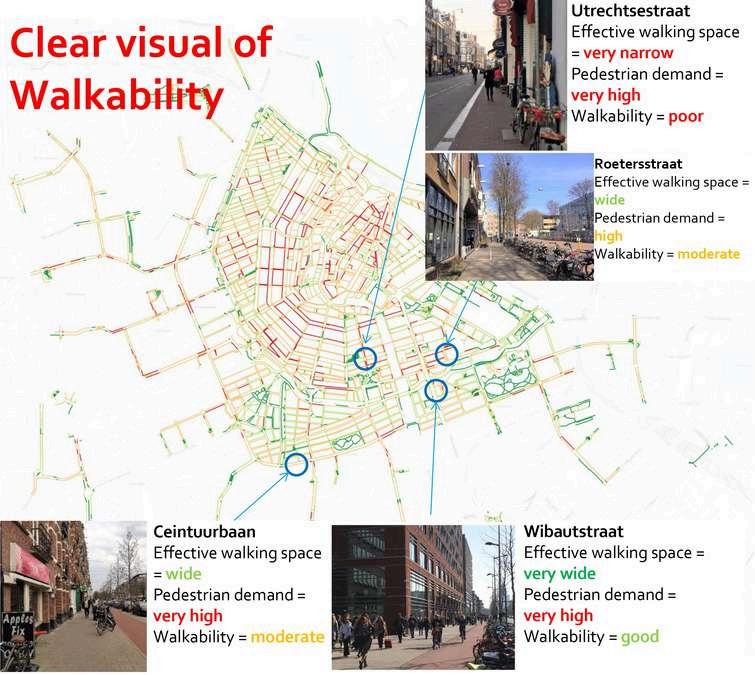
Map Highlights: Studies like the one by urbanNext show detailed maps that highlight highly walkable neighborhoods in Amsterdam, identifying zones with diverse amenities easily accessible on foot.
Residential and Commercial Proximity: The close proximity of residential, commercial,recreational areas enhances the accessibility of everyday needs, reducing dependency on transport.
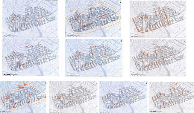
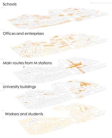
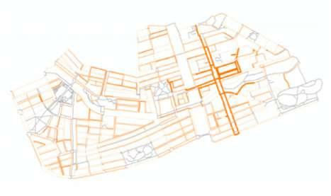
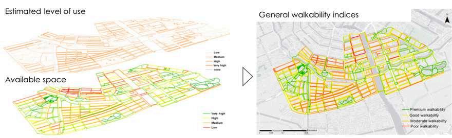
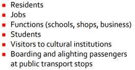
Walking experiences
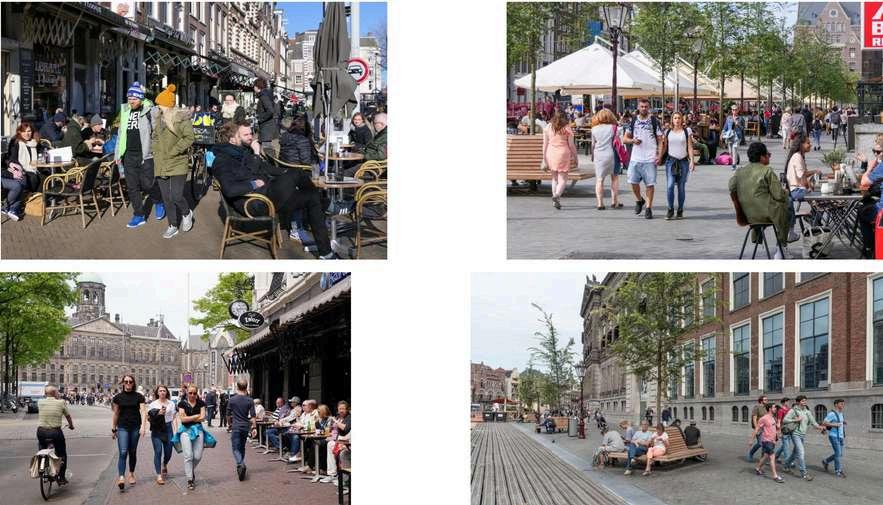
Perceived crowdedness
Walkability indices
Pedestrian-Centric Infrastructure
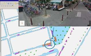
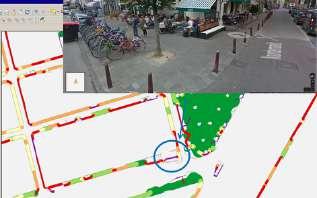
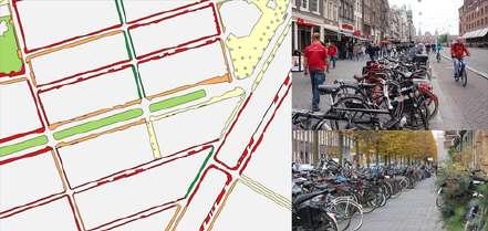
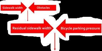
Amsterdam’s pedestrian infrastructure includes wide sidewalks, pedestrian-only streets, and well-connected plazas designed to encourage walking as a primary mode of transport The "Sidewalk Labs" initiative focuses on understanding Amsterdam’s sidewalk quality, which varies based on foot traffic and connectivity It also considers sidewalk width, ease of navigation, and safety, creating a more inclusive experience for all pedestrians, including those with disabilities
Public Spaces: Public squares and green spaces are strategically integrated, providing social spaces and increasing walkability for locals and tourists alike
Street Furniture and Wayfinding: Benches, signs, and street lighting contribute to an inviting, pedestrianfriendly environment, while wayfinding tools help both locals and visitors navigate the city
Sidewalk with objects
Cycling Infrastructure’s Role in Walkability
Amsterdam is globally recognized as a bicycle capital, which indirectly supports walkability Bicycles reduce car congestion, improving the safety and accessibility of pedestrian spaces This bike-friendly infrastructure aligns with the city’s goal of reducing car dependency and promoting sustainable mobility As noted in The Guardian article, Amsterdam’s commitment to cycling was driven by the "Stop de Kindermoord" movement in the 1970s, which advocated for child safety and led to fewer cars and safer streets for pedestrians
Bicycle Lanes and Parking: Extensive cycling lanes run parallel to pedestrian pathways, ensuring that both cyclists and walkers coexist harmoniously without obstructing each other
Reduced Car Usage: Policies limiting car access in certain districts have shifted the transportation culture towards non-motorized travel, creating safer, more walkable streets
Challenges and Future Plans
While Amsterdam’s walkability model has achieved significant success, challenges remain. Balancing tourist influx with resident needs and ensuring maintenance of infrastructure are ongoing priorities. Future development plans emphasize expanding walkable zones, enhancing public spaces, and integrating smart technology for better crowd management and pedestrian experience.
Conclusion
Amsterdam serves as a pioneering example of a walkable city, demonstrating that urban planning prioritizing pedestrian and cycling infrastructure can lead to a healthier, more sustainable, and vibrant city life By investing in accessible, pedestrian-centric urban layouts and reducing reliance on cars, Amsterdam continues to inspire cities worldwide to adopt similar strategies, paving the way for more sustainable urban futures.
An estimated 38% of all trips in Amsterdam are made by bike
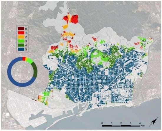
https://www researchgate net/publication/358588247 Barcelona under the 15Minute City Lens Mapping the Accessibility and Proximity Potential Based on Pedestrian Travel Times
Barcelona has emerged as a model for the 15-minute city concept, where residents can access essential services within a 15-minute walk or bike ride By implementing "Superblocks" (Superilles), Barcelona has prioritized pedestrian-friendly streets, improved public spaces, and reduced car dependency, making urban living more accessible and sustainable
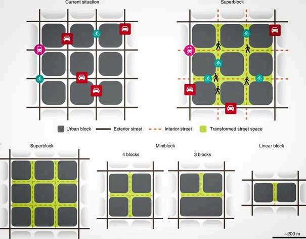
Superblocks model
Concept: Superblocks are clusters of city blocks where through-traffic is restricted, turning inner streets into spaces mainly for pedestrians and cyclists This layout not only reduces pollution but also enhances the quality of life for residents by creating safer and quieter neighborhoods
Recipe for a Superblock: Take 9 blocks on a 3×3 grid. Close all the inner streets off to cars. Divert all traffic to the outer streets. That’s a superblock.
Implementation: Barcelona initially tested Superblocks in areas like Poblenou and later expanded this approach due to its success. The city aims to establish these pedestrian-first zones throughout its central and peripheral neighborhoods
Before-and-after quality of life measures in Sant Antoni show the effect that the superblock had just 2 years after implementation: Air Quality – Sant Antoni saw levels of NO2 reduce by 33% just one year
Quietness – One year after the superblock was completed, noise had reduced by 4 db Traffic reduction – significant decreases in vehicle usage (-92%) was met with no substantial increase in traffic in neighbourhing streets (+3%) The technical term is that the cars “evaporated”: people chose not to use them as often.
Enhanced Pedestrian Spaces: Superblocks in Barcelona feature wider sidewalks, pedestrianonly streets, and public squares, making it easier to walk to essential services and leisure areas. With over 75% of trips in Barcelona already done by walking or cycling, Superblocks enhance the safety and enjoyment of these modes.
Integrated Public Transit: Barcelona’s extensive transit network, connected with Superblocks, supports the 15-minute city by linking metro stations, bus lines, and bike-share systems. Planned expansions include a 40% increase in bike lanes and more bus lanes, reducing car dependency and enhancing neighborhood connectivity.
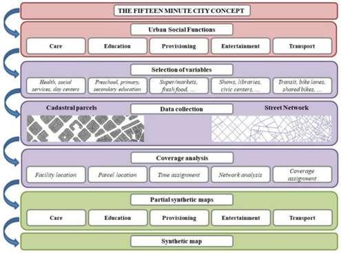
The proposed methodological approach Source: own elaboration based on data from Open Data BCN [42].
The FMC model
Five core urban functions necessary for FMC implementation:
Care (healthcare facilities and day centers), 1.
Education (schools at various levels), 2.
Provisioning (access to markets, supermarkets, and daily goods), 3.
Entertainment (libraries, civic centers, parks, and sports facilities), 4.
Transport (public transit and non-motorized options) 5
Data for these services were mapped using GIS, and network analysis was performed to determine service accessibility within specified walking times (typically 515 minutes, depending on the service). The analysis includes residential parcel data across Barcelona’s neighborhoods.
Findings
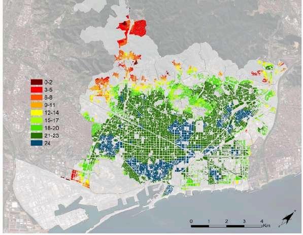
Overall Accessibility: Barcelona exhibits high FMC compliance, with most parcels having easy access to all major services, especially in central areas
Core Findings by Function:
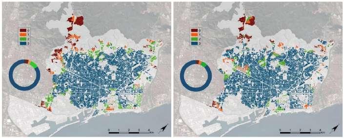
Care: Nearly 85% of parcels have proximity to health and social services
Education: Accessibility is optimal, with over 93% of parcels having access to educational institutions
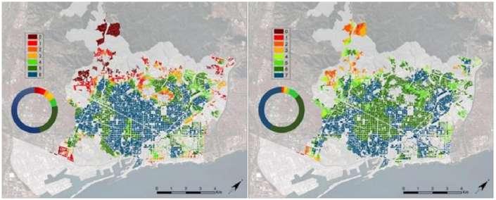
Provisioning: Food and essential daily services are well-distributed, although peripheral areas show slight deficits.
Entertainment: High coverage in recreational facilities exists citywide, though central areas lack large green spaces.
Transport: Public transit coverage is extensive, yet peripheral areas and some sector lack optimal access to bike lanes.
Barcelona’s urban design, characterized by high density, mixed-use spaces, and robust public facilities, makes it well-suited to the FMC model. Historical policies have decentralized essential services, enhancing the city’s proximity-based mobility and making it highly walkable. However, some peripheral areas lack comprehensive access to certain amenities, reflecting the impact of suburban planning focused on high-rise buildings and limited commercial spaces The study concludes that Barcelona largely meets FMC criteria, making it a model for other dense urban areas It emphasizes the need for metropolitan-scale FMC analysis to address broader mobility patterns Future research should incorporate sociodemographic factors and housing data to further refine FMC metrics and consider real mobility behaviors
Conclusion
Synthetic Map of the 15-Minute City in Barcelona.
Care features (left side) and education (right side)
Provisioning functions (left side) and entertainment functions (right side)
Melbourne
A Walkable City for the Future
SOURCES: Transport Strategy refresh Background paper: Walking , March 2018; Place, Health and Liveability Research Program; Walking and transport in Melbourne suburbs, Victoria Walks; Global Street Design Guide, 2022
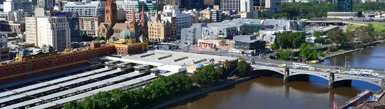
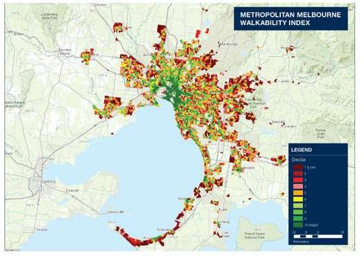
Walking is fundamental to the lives of Melbourne’s residents The CBD and inner suburbs were designed before the car and so planned around people rather than vehicles The inner suburbs also tend to be high density with high quality public transport and shops, services and employment within short distance of housing In comparison, the middle and outer suburbs have been designed around vehicle access, with high speed, wide roads, low density housing and shops and services generally concentrated in standalone locations rather than integrated where people live Public transport and employment options are limited or not available in many outer suburbs
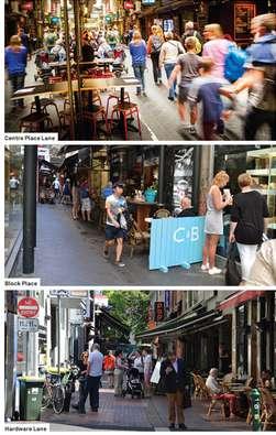
Laneways Of The City
The City of Melbourne’s streets and laneways are intrinsic to its distinctive character and identity. Walking on grand Collins Street, lively Bourke Street Mall, bustling Errol Street or through the dense network of laneways and arcades is a major part of our experience of the city. The quality of this experienc perceptions of the quality o metropolitan area as a place shop, visit or reside
The network of laneways im legibility within the Central while providing attractive en support local businesses.
Key Elements
Pedestrian-priority spaces with no vehicular traffic
Quality paving materials and custom designed lighting
Removal of obstacles, bollards, curbs, and redundant street elements
Improved cleaning, supervision of laneways, and wayfinding
Activation including cultural and arts events.
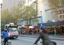
Road Section Of Swanson St.
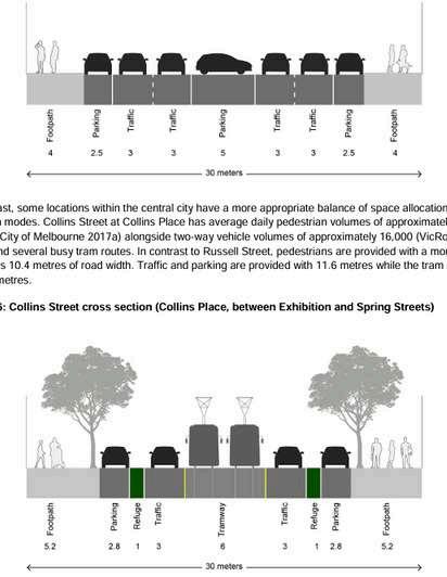
Russell Street’s footpaths are relatively narrow approximately 4 metres wide and in some loca alfresco dining and street clutter reduces the walkable width of the footpath to 2 metres. Around 8 metres of street width is allocated to
Purpose and length of walking trips
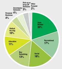
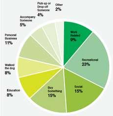
Most trips with any walking component are made to get somewhere i e for transport Key purposes are work, social trips and shopping trips, which when combined make up half of all trips
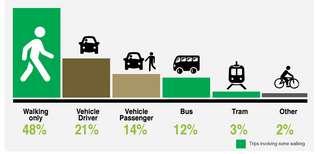
Purpose of trips with any walking, including public transport trip
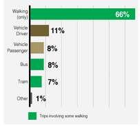
Purpose of walk-only trips
Apart from the CBD, high levels of walking to work are seen around Monash University, Clayton; the Police Academy, Glen Waverley; Box Hill; and Swinburne University, (Loader 2018).
This could be re ective of the number of people who live on campus and the high densities of housing and jobs in these areas
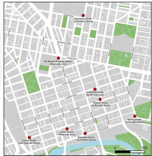
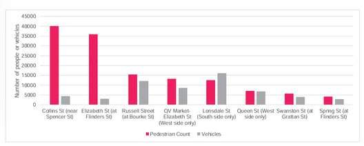
Average daily numbers of people walking and numbers of vehicles using selected City of Melbourne streets
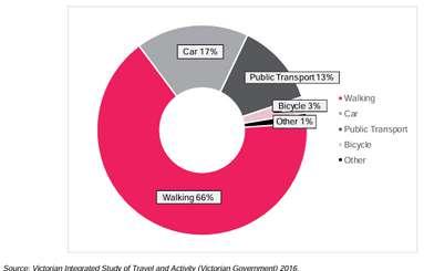
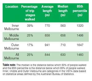
The analysis of VISTA found that 16% of trips are walk-only trips and an additional 8% had atleast one walking stage (24% in total with some walking involved).
By comparison, a similar proportion of trip stages are also walked (25%). More trip stages are walked closer to the central city, but further from the city walking stages tend to be over longer distances.
For trips where walking was the only mode, the proportion of work-related trips drops signi cantly but trips for recreational, social and shopping purposes remain important
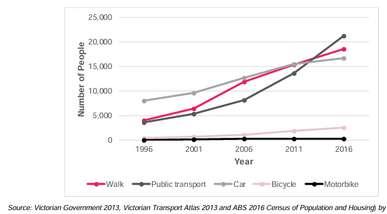
In Melbourne, walk-only mode share for people travelling to work has grown over the past decade while travel by private vehicle is shrinking (Department of Transport 2019). Walking all the way to work is most common for people who live in the inner city, with a mode share greater than 40% in some areas.
Percentage Of trip stages that are walked
Across all areas of Melbourne, there are lots of shorter walking stages. Short walking trip stages facilitate longer trips by multiple modes, for example walking combined with public transport.
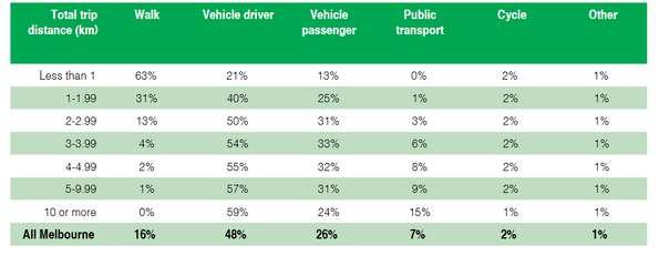
Most trips less than 1 km in total length are walked. The proportion of people walking reduces as the distance gets longer.
(between Exhibition and Spring Streets)
Trips within the City of Melbourne by mode, average weekday
Method of travel to work
Mode share by trip length
Public transport & Walking
Public transport and walking Nearly all trips involving public transport made in Melbourne also include some walking (97%), at either the origin or destination If trips by school bus are excluded, then basically all public transport trips include some walking (99%)
People walk the longest distances for exercise or recreation, compared to work and personal business trips, which are about half the length
Walking throughout the week
Trip stages on weekdays are more likely to be walked (27%) compared to weekends (21%)
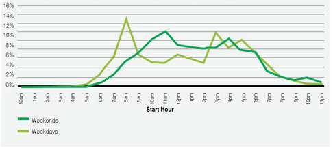
Weekend walking is concentrated in the middle of the day, compared to walking on weekdays, which has three peaks:
• between 8 and 9am
• between 3 and 4pm
• between 5 and 6pm
This is due to people walking for work related purposes, trips using public transport (24% of trips involving walking are walked on weekdays compared to 4% on weekends) and education (14% and 1% respectively)
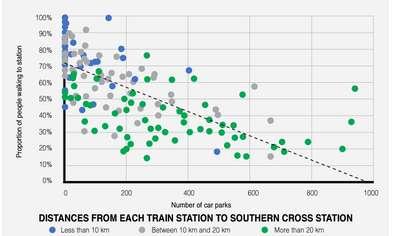
This strong correlation between the proportion of people who walk to each train station and the number of car parks provided (R2 value of 0.5). This means that the number of car parks available explains about half of the reasons people walk to the train station. At train stations with fewer car parks, a greater proportion of people walk Similar to findings for walking in Melbourne, people who live further from the CBD (stations shown in green) are less likely to walk than those closer to the CBD (shown in blue) This is likely to reflect the broader urban design of the neighbourhood
Some people driving to the station travel only short distances, with nearly one in four people (24%) driving from home to a train station travelling less than 2 km The average distance driven is 4 77 km In addition, people do not always drive to their closest station due to service reliability and frequency, parking availability, etc
Conclusion
Melbourne exemplifies how prioritizing walkability can create a vibrant, sustainable, and people-centered city. Through pedestrian-friendly streets, accessible transit, and integrated green spaces, Melbourne enhances quality of life, reduces environmental impact, and fosters community connection. Its approach serves as an inspiring model for cities aiming to balance growth with sustainability and livability.
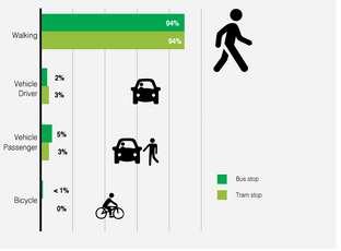
This found walking is even more important for accessing buses and trams than trains. Nearly all trips stages to access a bus or tram are walked. When trip stages from all locations are included, 96% to bus stops are alked and 98% to tram
Percentage
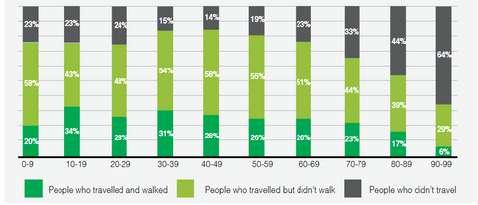
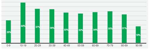
People who walked as a proportion of those who recorded travel on the survey day - by age group
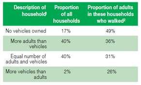
Proportion of adults who walk compared to vehicles in a household
Comparison of trip stages walked on weekday/weekends by time of day
Trips by mode from home to the train station
Trips by mode to the train station
Number of people walking and the number of commuter car parks at each suburban train station
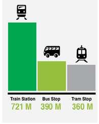
Distance walked from home to public transport
Access mode to bus and tram stops from home
HANOI, VIETNAM
Expanding Pedestrian Zones and Car-Free Areas
SOURCES: https://thecityateyelevel.com/stories/walkability-in-asian-cities/, Journal of the Eastern Asia Society for Transportation Studies, Vol.11, 2015, https://naturalwalkingcities.com/vietnam-and-laos-pedestrian-zones-a-review-hanoi-hoi-an-ho-chiminh-luang-prabang-vientiane/, https://issuu.com/stipoteam/docs/cael ebook def single-pages/s/11210032
Introduction
Hanoi, Vietnam’s bustling capital, has made considerable strides in enhancing its walkability. Faced with rapid urbanization and the rise of private vehicle use, the city has responded by designing and implementing a series of measures that prioritize pedestrians. These efforts aim to reduce pollution, improve public health, boost tourism, and foster a greater sense of community. This report outlines the strategies and initiatives that have contributed to Hanoi’s reputation as a more walkable, livable city.
Expanding Pedestrian Zones
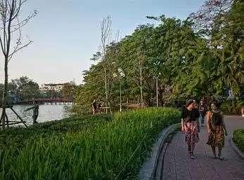
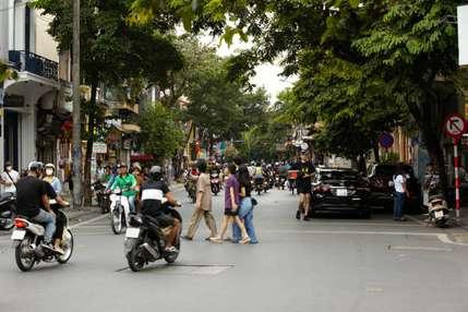
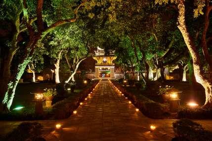
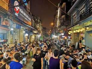
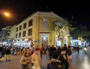
Hanoi has introduced pedestrian-only areas, most notably around Hoàn Kiếm Lake, enhancing foot traffic and providing vibrant spaces for public events and local businesses. Inspired by this success, the city has implemented similar weekend closures in the Old Quarter, creating safe zones for residents and tourists while boosting local commerce
Greening the City
The “Greening Initiative” launched in 2014 has added thousands of trees, parks, and green corridors These shaded walkways provide a cooler, more pleasant walking environment and support Hanoi’s goals for a sustainable, green urban landscape By 2030, the city aims to add 18 new parks and improve 42 existing ones, offering both aesthetic and environmental benefits Hanoi’s transformation includes beautifying lakes, cleaning the water, and creating shaded walkways These areas now serve as recreational spots and scenic pedestrian routes, enhancing the city’s natural appeal and promoting eco-friendly urban spaces
Improved Connectivity and Safety
Hanoi has upgraded sidewalks, crossings, and pathways connecting residential areas to transport hubs. These improvements make walking safer and more accessible, encouraging residents to walk the “first and last mile” of their journeys. The city has invested in well-lit pedestrian paths and traffic calming measures.
Hanoi’s walkable Hoàn Kiếm Lake footway
Cultural and Community Impact
Hanoi’s pedestrian zones have become social and cultural centers, with events, performances, and public gatherings that foster a strong sense of community These areas not only provide residents with public spaces but also make Hanoi more attractive to tourists, reinforcing the city’s commitment to a walkable, lively urban culture
Survey
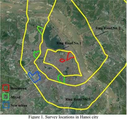
A study conducted with 300 households in Hanoi examined how perceived neighborhood walkability influences mode choice for short trips. The survey covered three types of neighborhoods: downtown, mixed-use, and new urban areas. Published in the Journal of the Eastern Asia Society for Transportation Studies in 2015, the study found a significant link between neighborhood characteristics, walkability perceptions, and transportation choices like walking, cycling, and motorcycling.
Key findings
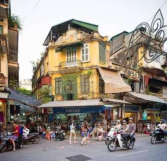
Downtown Neighborhoods: High walkability led to more walking for short trips, thanks to better aesthetics, walking facilities, and street connectivity.
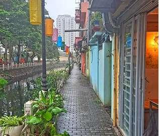
Mixed Neighborhoods: Despite lower walkability, these areas had high walking and cycling rates due to foot accessibility and shade from trees.
New-Urban Neighborhoods: Low walkability scores resulted in more motorcycle use, with lack of pedestrian infrastructure and safety concerns being key factors.
Factors Influencing Walkability Perceptions:
Key factors included access to services, traffic safety, crime perception, aesthetics, and walking facilities. Principal Component Analysis identified eight main influences: accessibility, crime, aesthetics, walking facilities, trees, traffic conditions, street connectivity, and traffic speed.
Statistical Analysis and Methodology:
A multinomial logit model found that accessibility and crime fear significantly impacted mode choice. Improving walking infrastructure and security could reduce motorcycle use, encouraging more sustainable transportation.
Implications for Urban Planning:
The study suggests improving pedestrian infrastructure, reducing crime, and enhancing aesthetics and connectivity to promote walking, especially in new-urban areas where walkway networks, lighting, and nearby amenities are lacking.
Conclusion
Enhancing walkability can reduce motorcycle dependency and encourage sustainable transportation. The study offers insights for urban planners and highlights the need for further research on environmental factors and reintroducing cycling in Hanoi.
Downtown Neighborhoods
Pedestrian zones
The charming neighborhood of truchbach, Hanoi
Seoul
Walkability in a Modern Metropolis
SOURCES: Walkable and Bikeable Cities-Singapore & Seoul, Research Paper by Eun Jung Kim- Is Seoul Walkable? Seoullo 7017 Project
In Seoul, decades of serious traffic congestion are projected to chalk up to KRW 22 trillion in costs by 2030, a significant increase from KRW 7 trillion in 2008 The Seoul Transport Vision 2030 is a mobility paradigm shift that aims to create a people-centric transport system focusing on public transport, pedestrians and cyclists It is underpinned by a comprehensive public transport system created through decades of investments in urban rail networks and a major bus system reform in 2004 This provides a viable alternative for people to move around the city through a combination of active mobility and public transport, without the need for private cars
People-first Transport Vision
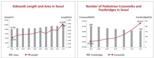
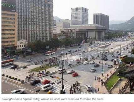
Seoul’s new people-first transport vision that prioritises people and the environment is already being realised. Seoul has been actively narrowing roads to create sidewalks and cycling paths for pedestrians and cyclists since the early 2000s. To facilitate more direct pedestrian connections, Seoul has also progressively removed footbridges and introduced pedestrian crosswalks throughout the city. Key projects like the Yonsei-ro Transit Mall accessible only to buses, emergency vehicles and pedestrians were established by SMG to encourage public transport use and discourage driving.
Walkability and Accessibility
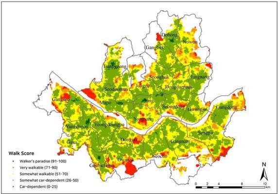
Seoul’s high walk score is a testament to its commitment to creating a city that prioritizes pedestrians, making it one of the most accessible and enjoyable cities to explore on foot. With a focus on extensive car-free zones, well-connected sidewalks, and the integration of green spaces and parks throughout urban areas, Seoul offers a vibrant, walkable environment that benefits both residents and visitors. These developments not only increase convenience and promote healthier lifestyles but also reduce traffic congestion and environmental impact As Seoul continues to enhance its walkability, it sets a benchmark for urban sustainability, illustrating how thoughtful design can transform a bustling metropolis into a livable, connected, and eco-friendly city
This prioritizes walkability by expanding car-free zones, improving pedestrian infrastructure, and integrating green spaces These efforts enhance safety, accessibility, and sustainability, making Seoul a more connected and livable city for residents and visitors.
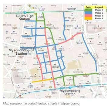
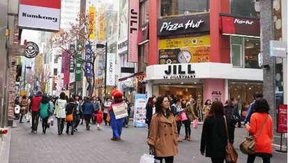
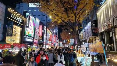
Myeongdong is known for its crowded streets filled with tourists and shoppers A study on Seoul’s daytime population shows that seven of the city's ten busiest spots are in Myeongdong, with Noon Square seeing up to 97,000 pedestrians daily People flock to Myeongdong for its unique charm, with small stores lining its streets instead of large malls The pedestrian-friendly environment, created through policies like underground utilities, improved walkways, and car-free streets, adds to its appeal Myeongdong's popularity as a walkable shopping district reflects years of gradual enhancements that preserve its distinct character
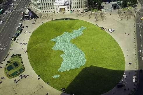
Seoul Plaza is a historic and symbolic urban space in front of Seoul City Hall and is a showcase of unprecedented development of a large grassy area. An average of 20,00030,000 people visit the Plaza daily and a variety of cultural events and programmes inspire the city.
Gwanghwamun Square offers a representative view of the city and contributes to tourism; and it has improved the urban environment for pedestrians. An average of 12,871 visitors come to the Square on weekdays and 24,514 on weekends. Its peaceful environment as part of the “emptiness” principle have made it a popular place for people to come and relax in.
Conclusion
Seoul’s commitment to walkability has transformed it into one of the most accessible, vibrant, and sustainable cities in the world Through extensive car-free zones, well-maintained sidewalks, and abundant green spaces, the city has made walking a central part of daily life, encouraging healthier lifestyles and reducing traffic congestion and pollution These pedestrian-friendly designs make neighborhoods more interconnected, allowing residents and visitors to easily access shops, parks, and cultural sites on foot Beyond convenience, Seoul’s walkability initiatives also prioritize safety and inclusivity Investments in well-lit pathways, accessible crosswalks, and traffic-calming measures create a safer environment for pedestrians of all ages and abilities Public spaces encourage social interaction and community engagement, enhancing the city's sense of community and livability By continuously investing in people-centered, walkable design, Seoul sets a powerful example for other cities
Secondary Case Studies Pedestrian Infrastructure
1. Paris
Paris features wide boulevards, iconic pedestrian zones and abundant parks, making the city easy to navigate on foot.
Pedestrian-only streets, especially around central and tourist areas, add to the city's walkability.
2. Amsterdam
3. Barcelona
Amsterdam’s compact layout, narrow streets, and canal system make it highly walkable.
The city’s pedestrian infrastructure includes extensive car-free zones and areas designed specifically for walking and cycling.
Paris offers a world-class integrated public transit system, including the Metro, RER, buses, and trams. Stations are conveniently located near popular pedestrian zones, allowing for easy transfers between walking and transit.
Paris is generally safe for pedestrians, with wellmarked crosswalks and pedestrian signals. Efforts are being made to improve accessibility, including enhancing metro stations and public spaces for people with disabilities.
Paris is heavily focused on sustainability, with measures in place to reduce emissions, promote walking, and encourage cycling. Green spaces enhance the city’s air quality, and public spaces promote social engagement and outdoor activities.
4. Melbourne
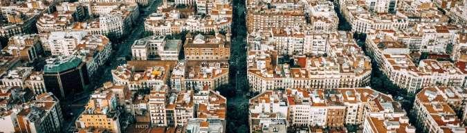
Barcelona is known for its pedestrian-friendly grid layout, particularly in the Eixample district. The city has many pedestrian-only streets and plazas, where walking is the primary mode of transportation.
The city’s trams, buses, and metro systems are excellently integrated into the pedestrian environment. Many transit stations are located near major walkable areas, making transitions between walking and public transport easy.
Amsterdam is considered one of the safest cities for pedestrians. Traffic is wellregulated, and there is clear differentiation between pedestrian, cycling, and vehicle paths. Accessibility is also a priority, with wellmaintained infrastructure for all users.
The city's metro, buses, and trams are well integrated, with stations located near key pedestrian areas. Barcelona’s public transport system encourages walking, especially in the central districts and in areas designed to be car-free.
Melbourne has wide sidewalks, city squares, and laneways, making the city center highly walkable. The integration of parks and public spaces encourages walking, though the walkability of suburban areas could be improved.
The tram network in Melbourne is one of the largest in the world and is well-integrated with the city’s pedestrian pathways. Buses and trains also provide access to major pedestrian hubs, making it easy to switch between walking and public transport.
Hanoi’s Old Quarter is highly walkable, with narrow streets and vibrant local life, making it an attractive area for pedestrians. However, traffic congestion, lack of pedestrian infrastructure, and limited sidewalks in other areas can make walking challenging.
Hanoi’s public transport system is still in development, with buses being the main mode of transport. The introduction of a metro system is expected to improve transit integration, but pedestrian infrastructure remains limited.
Barcelona is one of the safer cities for pedestrians, with wide sidewalks, well-marked crossings, and increasing efforts to improve accessibility for all, including the elderly and disabled.
The city’s widespread use of bicycles and walking, combined with the abundant parks and public spaces like Vondelpark, fosters a healthy and socially connected urban environment.
Barcelona emphasizes sustainability through green initiatives and the creation of carfree zones (superblocks) that reduce pollution and enhance the quality of life. Socially, these pedestrian areas help build community interactions, and public parks.
Melbourne is generally safe for pedestrians, with many pedestrian-only zones and well-maintained sidewalks. The city continues to improve accessibility, including enhancing public transport options for people with disabilities and increasing accessible pedestrian crossings.
Pedestrian safety is a concern in Hanoi due to high traffic volume and a lack of dedicated pedestrian infrastructure in many areas. However, in more touristcentric regions, pedestrian zones and crosswalks have been introduced to improve safety.
Melbourne’s focus on sustainability includes promoting walking and cycling to reduce emissions. The city’s laneways, parks, and vibrant public spaces contribute to a socially connected environment, though car use remains a challenge in some areas.
Hanoi struggles with air pollution from traffic, which impacts the environmental quality of walking. However, efforts to introduce pedestrian-only zones in the Old Quarter and expand green spaces are helping improve social and environmental sustainability. The city's walkability offers rich cultural experiences, fostering social interaction in the heart of the city.
Seoul features a well-developed pedestrian infrastructure, including car-free zones, pedestrian bridges, and green spaces . Many commercial and cultural areas are designed to prioritize pedestrians.
Seoul’s public transit system, including subways, buses, and shared bike services, is highly integrated with pedestrian paths. Transit stations are well-connected to the city's walkable areas, making it easy to use public transport while walking.
Seoul has made significant improvements in pedestrian safety, with clear signage, traffic-calming measures, and pedestrian-only zones. Accessibility is improving, with facilities like ramps and elevators at subway stations to accommodate people with disabilities.
Seoul is committed to sustainability, with a focus on reducing emissions through the promotion of walking, cycling, and public transport. Green spaces contribute to environmental health, while pedestrian areas foster social interaction and communitybuilding.
C O M P A R I T I V E A N A L Y S I S
5. Hanoi
6. Seoul
Primary Case Study Analysis and Walkability Assessment
1.
1.1
Introduction
Background
The concept of walkability and 15-minute cities has gained attention as cities worldwide aim to promote sustainable and pedestrian-friendly environments. A walkable city reduces reliance on cars, fosters healthier lifestyles, and supports economic activity This report focuses on analyzing the walkability index of three locations in Delhi INA Dilli Haat, Laxmi Nagar, and Vasant Kunj. These areas have been selected for their unique urban characteristics, population densities, and proximity to metro stations, making them suitable for a 15-minute city model assessment.
1.2 Objectives
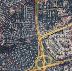
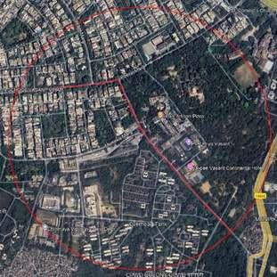
To evaluate pedestrian accessibility and safety within a 500-meter radius of the metro stations at INA Dilli Haat, Laxmi Nagar, and Vasant Kunj.
To calculate the walkability index for each location based on the Ministry of Urban Development (MOUD) guidelines
To identify the existing challenges and suggest improvements for pedestrian facilities.
1.3 Significance of Selected Locations
INA Dilli Haat: Known for its vibrant market and cultural center, frequented by both locals and tourists, creating a high footfall area.
Laxmi Nagar: A densely populated commercial and residential hub with high pedestrian and vehicular traffic.
Vasant Kunj: A mixed-use area encompassing residential complexes, shopping malls, and educational institutions, creating varied pedestrian needs.
INA Dilli Haat
Laxmi Nagar
Vasant Kunj
2. Methodology
2.1 Study Area Selection
Each location was selected based on:
Proximity to metro stations (within a 500-meter radius)
Variation in population density and land use.
Accessibility and safety for pedestrians in high-traffic areas.
2.2 Data Collection and Tools
Data was gathered on-site using the following methods:
Observation and Survey: Pedestrian surveys and observations on footpath width, obstructions, and safety facilities.
Photographic Documentation: To capture existing conditions of pedestrian pathways, footpaths, and surrounding environments.
GIS Mapping: For precise measurement of distances from metro stations and footpath lengths
2.3 Walkability Index Calculation
Ministry of urban development (MOUD) method: This method was developed by Ministry of Urban Road Development (MOUD), Government of India. They especially developed this method based on the Indian conditions. According to this method walkability index is a function of availability of footpath and pedestrian facility rating This can be calculated using equation given below���������������������� ���������� = [(��1 × ���������������������� ���� ��������������ℎ) + (��2 × �������������������� ���������������� ��������������)] Where, W1 and W2 are weights (assumed 50% for both); Availability of footpath = Footpath length / Length of major roads in the city; Pedestrian Facility Rating = Score estimated based on opinion on available pedestrian facility.
INA Dilli Haat
Laxmi Nagar
Vasant Kunj
INA Dilli Haat
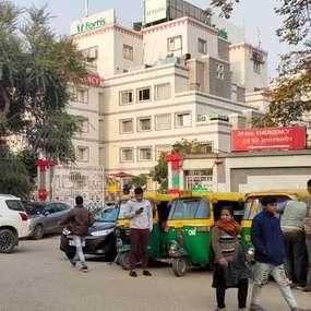
INA Dilli Haat is a well-known cultural and commercial center located in South Delhi, characterized by its vibrant marketplace offering handicrafts, cuisine, and cultural exhibitions. This area draws a diverse crowd, including local residents, tourists, and daily commuters. The high pedestrian traffic due to its proximity to the INA Metro Station makes it an ideal site to assess pedestrian infrastructure needs.
Current Conditions:
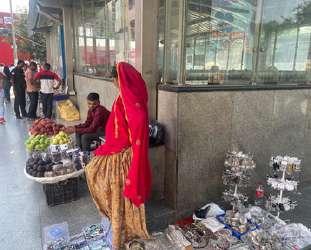
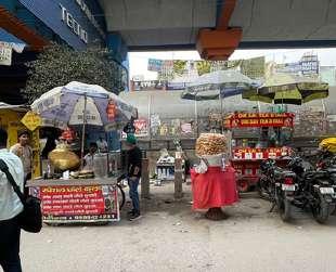
Footpath Design: Pathways around INA Dilli Haat vary in width, often narrowing near market entries and crowded intersections The pathways are intended to support both visitors and local vendors but are often obstructed by temporary stalls, leading to congested conditions
Safety and Accessibility:
Pedestrian crossings are limited, with some areas lacking clearly marked paths or traffic signals, which poses risks in high-traffic zones. The lighting around the area is inconsistent, creating potential safety concerns, especially at night
Environmental Challenges:
The market’s outdoor setting means pathways are frequently exposed to wear from weather conditions, affecting the footpath’s surface quality and accessibility.
Opportunities for Improvement:
Improved vendor zoning to control the placement of stalls and ensure wider, unobstructed pathways
Installation of additional crossing points with pedestrian signals to enhance safety.
Increased, consistent lighting along primary pathways and crossings for better night-time visibility
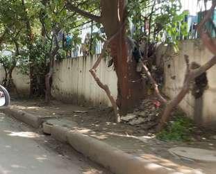
Broken pathways
Poorly maintained pathways
Exposed pathways without shade provision
Encroachment by hawkers
Obstructions on footpath
Encroachment by shopkeepers
Laxmi Nagar
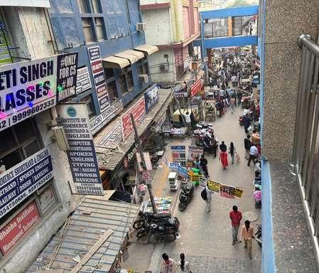
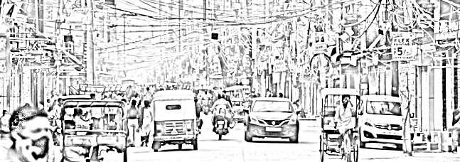
Laxmi Nagar is one of East Delhi’s busiest commercial and residential areas Known for its dense population and heavy foot traffic, the area serves as a hub for shopping, residential buildings, and educational institutions. Its metro station acts as a significant point of connection for residents and commuters traveling across the city.
Current Conditions:
Footpath Constraints:
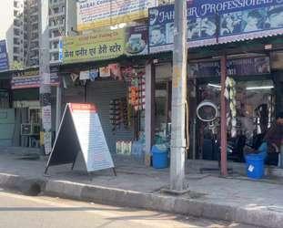
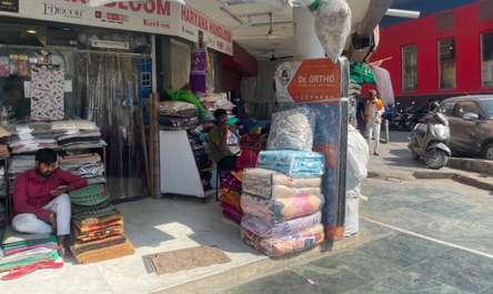
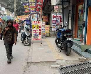
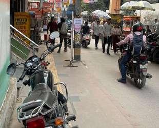
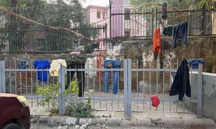
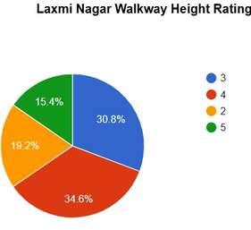
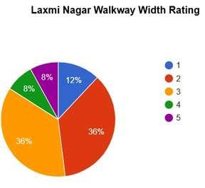
Footpaths in Laxmi Nagar are narrow and frequently interrupted by obstructions such as street vendors, illegal encroachments, and parked vehicles. Pedestrians often need to walk on the road due to a lack of dedicated pathways.
Pedestrian Safety: The area suffers from high pedestrianvehicle interactions due to the lack of well-defined pedestrian crossings With limited signage and absence of barriers, the footpaths do not offer sufficient protection from vehicle traffic, increasing risks for pedestrians
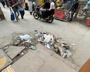
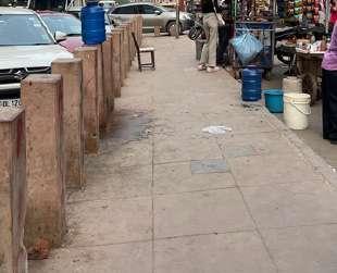
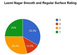
Infrastructure Maintenance: The footpaths are often poorly maintained, with cracked surfaces and debris, making them difficult for elderly residents, children, and those with disabilities to navigate.
Opportunities for Improvement:
Expanding and reinforcing footpaths to prevent encroachment and provide more space for pedestrians
Introduction of pedestrian-only zones or elevated walkways near highfootfall areas to reduce vehicle interference.
Regular maintenance and upgrades to footpath surfaces, ensuring they are even, clean, and free of obstructions.
Constrained pathway width
Encroachment by vendors
Obstructions on footpath
Encroachment on pathways
Vasant Kunj
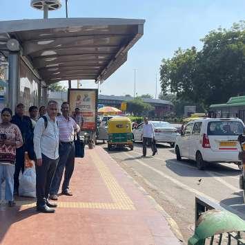
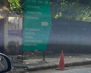
Vasant Kunj is a prominent residential and commercial neighborhood in South Delhi It includes luxury shopping centers, residential complexes, and several educational institutions, attracting a wide demographic of users. The Vasant Kunj metro station serves as a key transit point for students, residents, and shoppers.
Current Conditions:
Footpath
Design and Width:
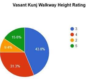
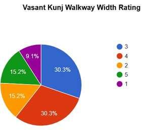
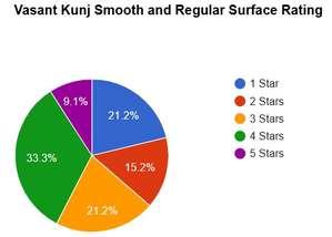
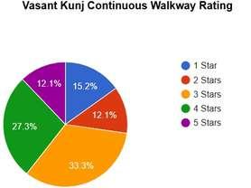
Unlike the other areas, Vasant Kunj has wider footpaths, but these are not uniformly distributed across the area Some pathways are well-maintained, while others have inconsistent widths, affecting pedestrian experience.
Night-Time Illumination:
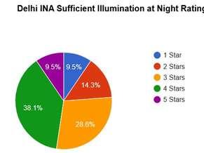
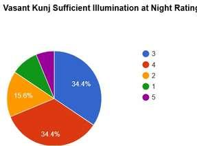
While certain parts of Vasant Kunj have good lighting, others remain dimly lit, making them unsafe for pedestrians after dark.
Traffic and Accessibility:
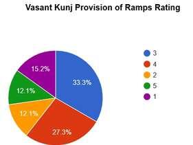
Although footpaths are wide in some sections, the area lacks sufficient raised pedestrian crossings and traffic separators, leading to potential conflicts between pedestrians and vehicles.
Opportunities for Improvement:
Installation of continuous raised crossings, particularly in high-footfall areas around the shopping centers and metro station.
Improved lighting across all footpaths, ensuring a safer environment for night-time walkers
Adding traffic separators or barriers on pathways closer to busy roads, enhancing safety for pedestrians by minimizing vehicle interaction.
raised footpaths for pedestrians
Constrained pathway width Insufficient Street lighting
left dug up
Encroachment and parked vehicles on pathways
3. Data Analysis and Calculation
3.1 Footpath Availability
The availability of footpaths will be calculated by measuring the total footpath length against the length of major roads in each 500-meter radius zone
Length of major road: 1000m
Length of footpath: 578m
3.2 Pedestrian Facility Rating
Length of major road: 1003m
Length of footpath: 983m
Length of major road: 1118m
Length of footpath: 868m
This rating considers various pedestrian facilities based on a survey using criteria such as pathway width, smoothness, lighting, accessibility, and cleanliness. Scores will be averaged to assess usability and determine areas needing improvement. These scores were taken on a scale of 1 to 5. The average value of the pedestrian facility rating must be divided by 5 to convert into a 1 point scale.
Table 1. Laxmi Nagar
INA Dilli Haat
Laxmi Nagar
Vasant Kunj
Table 2. INA Dilli Haat
Table 3. Vasant Kunj
3.3 Walkability Index
Where, W1and W2 are weights (assumed 50% for both)
Availability of footpath : Footpath length / Length of major roads in the city
Pedestrian Facility Rating : Score estimated based on opinion on available pedestrian facility
3.3a INA Dilli Haat Walkability Index
3.3b Laxmi Nagar Walkability Index
3.3a Vasant Kunj Walkability Index
4. Walkability Index Results
INA Dilli Haat: Relatively higher walkability index(1.18) with continuous pathways but frequent obstructions.
Laxmi Nagar: Low walkability index(0.76) resulting from encroachments and poor pedestrian infrastructure.
Vasant Kunj: High walkability(0.97), with well-maintained pathways but limited crossing facilities.
5. Conclusion
The walkability analysis using the MOUD method shows varying levels of pedestrian infrastructure in the three case study areas. While some areas fare moderately well, others require significant enhancements to align with walkable city standards. Addressing these concerns will enhance pedestrian safety, accessibility, and overall urban quality of life.