Closer Than You Think: The 15-minute Walkable City Vision in Delhi’s Diverse Districts
Manya Pugalia1 , Nishi Yadav2 , Vinayak Praveen3,Yashika4 , Neha Pareek 5
1B.arch, University School Of Architecture & Planning, Delhi, India manyapugalia04@gmail.com1
2B.arch, University School Of Architecture & Planning, Delhi, India nishiy2012@gmail.com2
3B.arch, University School Of Architecture & Planning, Delhi, India vinayakprvn@gmail.com3
4B.arch, University School Of Architecture & Planning, Delhi, India yashikamadan04@gmail.com4
5Asso. Professor, University School Of Architecture & Planning, Delhi, India Ar.npareek@gmail.com5
Abstract
The notion of walkability is growing its importance with rapid urbanisation in India as well as creating obstacles in attaining sustainability along with equitable urban living With the growing & densified cities it's getting difficult for residents to have equal access towards key services in their neighbourhood The research focuses on a human centric urban design framework conceptualised by Carlos Moreno- 15 minute city concept The study highlights the need of accessibility to basic aminities.
The research uses Delhi as a major case study to evaluate the framework's practical applicability in the Indian urban context, focussing on varied neighborhoods such as INA, Laxmi Nagar, and Vasant Kunj These places exhibit a wide range of urban environments, from mixed-use dense markets to residential enclaves with varied degrees of connection The study examines walkability indicators such as pedestrian infrastructure, safety, and the geographical distribution of facilities It also investigates the relationship between urban density and the availability of public transport infrastructure, which is critical in implementing the 15-minute city plan. To contextualize its findings, the study compares them to worldwide case studies from Melbourne, Amsterdam, Hanoi, and Seoul, where pedestrian-first, proximity-based urban planning principles have been successfully implemented. These examples demonstrate the significance of cultivating diverse, accessible, and pedestrian-friendly neighborhoods to develop livable cities By examining these global precedents alongside Delhi's urban fabric, the study provides policymakers and urban planners with actionable recommendations. It calls for rethinking Indian cities as walkable, sustainable, and socially integrated spaces, addressing both urban people's immediate demands and the larger ideals of environmental sustainability and social fairness.
Keywords
15-Minute City,Superblocks(Superilles), Walk Score, Ubiquity(Digitalization), Tactical Urbanism.
1. Introduction
India's rapid urbanization has put a strain on its urban infrastructure, exacerbating problems like traffic congestion, pollution, and unequal access to essential services (Banerjee, 2020). Motorized cars are prioritized over pedestrians in urban centers such as Delhi, Mumbai, and Bengaluru, posing significant issues Unsafe walking environments, poor sidewalk conditions, limited last-mile connectivity, and a lack of pedestrian-friendly infrastructure reduce accessibility and liveability in Indian cities (Kumar & Purohit, 2018) These structural deficiencies endanger public health and safety, aggravate socioeconomic inequality, and block progress toward sustainable urban development (Chakrabarti et al., 2022,).walkability is closely related to issues of urban design, public health, and social equity, and the focus on walkability measurement frameworks, standards, and variables varies across fields of scholarship (Giuffrida, Molter, Pilla, Carroll, & Ottomanelli, 2024).
The idea of the 15-minute city, popularized by Carlos Moreno, has revolutionized rethinking the urban area for these pressing problems This proximity-based approach in urban planning restructures urban life so that everything one needs from employment, health care, education, and recreation is accessible within a 15-minute walk or bike ride from home (Moreno et al , 2021) It encourages tight, people-friendly, and auto-independent neighborhoods by focusing on closeness. It is founded on three fundamental concepts: cities for people, not cars; multi-purpose urban space; and integration of living, working, and playing into the neighborhood form This approach tries to reduce traffic congestion, improve air quality, and develop healthier and more livable communities through reduced reliance on cars and increased consideration for walkers (Gehl, 2010 )
In India, the walkable city concept has to be included in achieving the 15-minute city. Apart from creating social cohesiveness through shared spaces and interactive surroundings, walkable cities promote physical activity and environmental sustainability through a reduction in greenhouse gas emissions (Rueda, 2019). Evidence from case studies of cities such as Melbourne, Amsterdam, Hanoi, and Seoul suggests that a walkable urban environment can positively be an ecology when the process of urban planning favors walking. Other than encouraging active lifestyles, walkable environments stimulate the economy (Tiwari & Jain, 2020) Walkable cities provide accessibility for vulnerable and marginalized groups, including women, children, and elderly people. The other pillar of this approach is mixed-use neighborhoods that blend commercial, residential, and recreational areas to maximize land use, supporting healthy and thriving functional urban ecosystems Technology is the backbone when it comes to implementation of the 15-minute city concept. Advanced smart city technologies like GIS, real-time data analytics, and urban monitoring systems were employed for the optimization of urban infrastructure, improvement of service delivery, and better utilization of resources (Bibri
& Krogstie, 2017) These technologies address the problems associated with scalability and heterogeneity typical of Indian cities that should ideally allow for data-driven urban planning and for more efficient management of pedestrian infrastructure
The existing studies lay a strong emphasis on the importance of walkability in transitioning towards sustainable city design
Factors such as land use, pedestrian infrastructure, and transit access influence walking behavior and urban sustainability according to studies that examined city level actors that specifically treat Stockholm, Nanjing and Mumbai (Li et al , 2019) Indian cities however, have their set of problems which include inherent cases of poor infrastructures, security and safety concerns, and heavy traffic For instance, A study in Mumbai points out safety reasons, absence of pedestrian crossings, and narrow and uneven pavements which dissuades walking especially in vulnerable populations, including female, children and older people from walking (Patel et al , 2021) With regard to neighborhoods of Delhi through this research using a 15 minute city framework these findings are enlarged further. This publication proposes practical recommendations in the construction of India's resilient walkable cities with an evaluation on walkability, accessibility, and urban density
For this shift, tactics must include improving public areas, distributing facilities fairly, and promoting transit-oriented development In the final analysis, embedding the 15-minute city into the procedures for planning India's cities could really change the face of liveability and resilience of Indian cities for a more inclusive and sustainable urban India in the years to come.
2. 15-Minute City
The 15-minute city is an urban planning idea that guarantees that all necessary facilities, including parks, shops, healthcare, education, and workplaces, are within a 15-minute bike ride or walk from home (Moreno et al , 2021) It encourages accessibility, diversity, and closeness with the goals of lowering reliance on cars, enhancing quality of life, and developing inclusive, sustainable communities. Shorter commutes, lower emissions, more robust local economies, better public health, and lively community interactions are some of its advantages (Moreno et al., 2021). High retrofitting costs, gentrification dangers, scalability problems in big cities, and behavioral change resistance are some of its obstacles Although transformative, its success hinges on careful execution and inclusive planning
3. Walkability
Walkability is the ease of walking around the area This is an urban design concept where ease of accessing nearby amenities by foot is measured. Safety, Comfort, convenience of the user with connectivity, accessibility & lighting of the area is marked
4. Walkability Index Calculation
Ministry of Urban Development (MOUD) method: This method was developed by the Ministry of Urban Road Development (MOUD), Government of India They have especially developed this method based on the Indian conditions According to this method, the walkability index is a function of the availability of footpaths and pedestrian facility ratings This can be calculated using the equation given below-
Where W1 and W2 are weights (assumed 50% for both);
Availability of footpath = Footpath length / Length of major roads in the city;
Pedestrian Facility Rating = Score estimated based on opinion on available pedestrian facilities
(Muzamil Rashid,Waseem Akram & Shahid Rasool Tarry, 2017)
5. Pedestrian Facility Rating
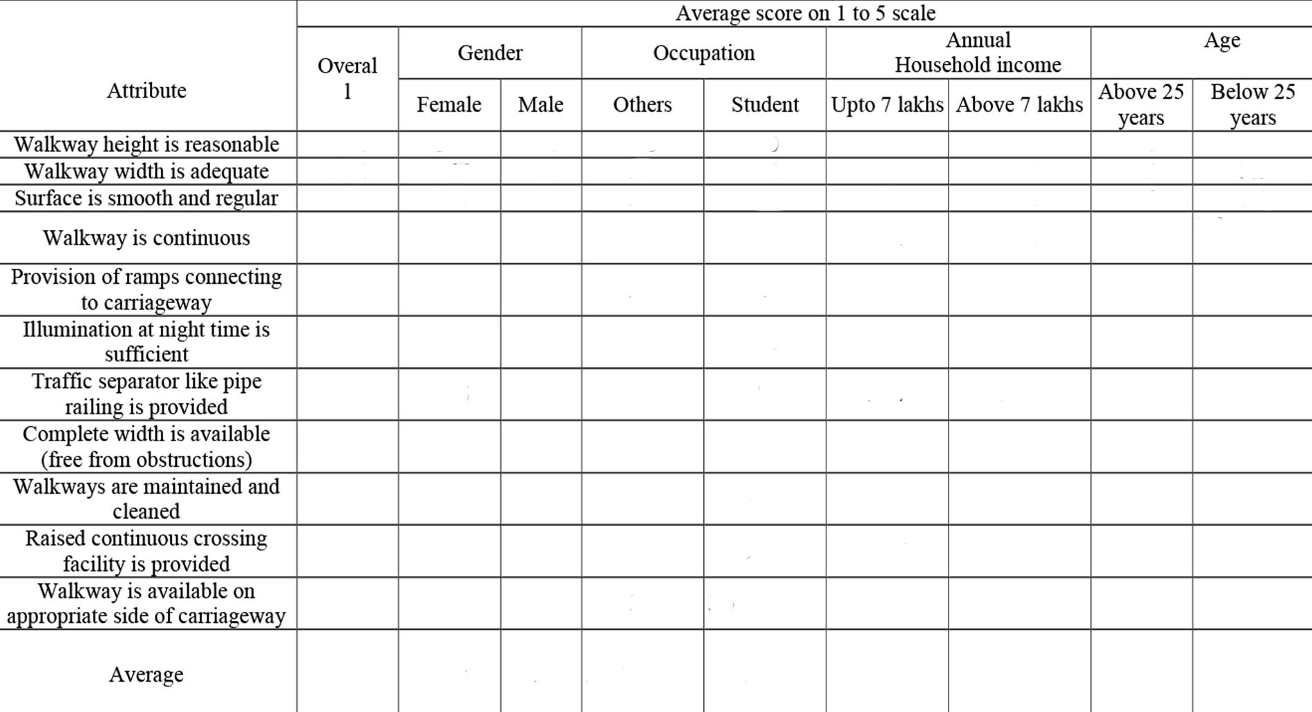
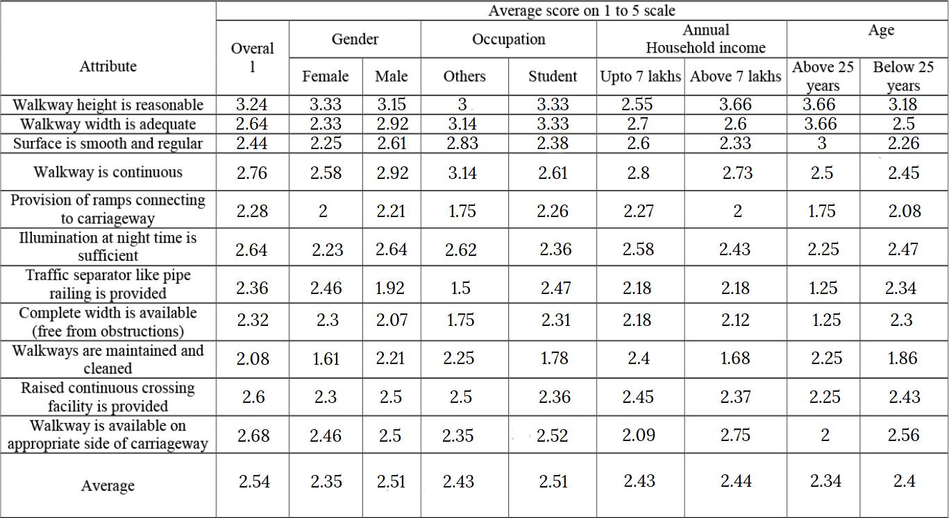
The pedestrian survey form considered several factors, including walkway height, width, surface quality (smoothness and regularity), continuity, availability of ramps connecting to the carriageway, nighttime illumination, traffic separators like pipe railings and handrails, obstructions, maintenance and cleanliness, raised continuous crossings, and whether the walkway is on the appropriate side of the carriageway While the Ministry of Urban Development (MOUD) method assessed only nine attributes, this survey included walkway height and appropriate placement alongside the carriageway, as these significantly influence the usability of pedestrian facilities (Muzamil Rashid,Waseem Akram & Shahid Rasool Tarry, 2017)
Participants rated the attributes on a 5-point usability scale, where ‘1’ indicated ‘not at all usable’ and ‘5’ represented ‘highly usable ’ Additionally, each attribute was assessed on an importance scale ranging from 0 to 100 to emphasize its significance in facility provision and usage Demographic data such as gender, age, occupation, and annual household income were also collected to understand the subjective and qualitative perspectives of users
A manual and online survey was conducted with approximately 100 participants. The average pedestrian facility ratings were derived from these responses. Using these values and a specified formula, the walkability index of the area was calculated
Literature Review
5.1 Melbourne, Australia
Melbourne's urban design is walkable, especially in the CBD and inner suburbs, where high-density housing, public transport, and services are well integrated In the outer suburbs, the city tends to be car-centric with minimal transport options The laneways and pedestrian-friendly streets of Melbourne, such as Bourke Street Mall, have improved connectivity while supporting local businesses Metropolitan Melbourne Transport Walkability Index It appears that walking accounts for 24% of trips, which is common near the CBD and within weekdays. Other determinants of walking patterns were proximity to transit and fewer car parks at train stations With Melbourne focusing on walkability, public transport, and green spaces, it acts as a model for sustainable and more livable cities (MRCagney,2018) (Eady, J and Burtt, D ,2019).
5.2 Amsterdam
A good example of a walkable city is Amsterdam, whose sustainability underlines the great deal of attention paid to pedestrian accessibility in urban planning Set forth, with a compact layout and dedicated lanes for cycling, accompanied by a powerful network of public transport, the city encourages walking, deterred from cars. The design of this urban space bases mixed-use zoning on essential services and green spaces, creating nexus neighborhoods Amsterdam’s pedestrian infrastructure, including wide sidewalks and pedestrian-only streets, enhances accessibility and inclusivity. The city's extensive cycling infrastructure also supports
Figure1. Pedestrian survey form by MoUD, GOI.
walkability by reducing car congestion and promoting safer pedestrian spaces
Overall, Amsterdam shows how investment in pedestrian and cycling infrastructure can result in a healthier, more sustainable, and vibrant urban environment (Martabuges,2020)
5.3 Hanoi, Vietnam
Efforts are being put forth in the face of fast-paced urbanization and increasing usage of private vehicles by Hanoi, Vietnam to promote walkability. Most importantly, creating pedestrian-only zones such as near Hoàn Kiếm Lake and the Old Quarter boost foot traffic and enhance local commerce They also give space for colorful public events The "Greening Initiative," launched in 2014, has added trees, parks, and green corridors to the city, enhancing the walking environment and supporting sustainability These changes have also fostered a strong community culture and attracted tourism A 2015 survey of 300 households found that downtown areas with the highest walkability rates reported the highest levels of walking and cycling, whereas new urban areas with lower walkability reported the most motorcycle use The study emphasizes pedestrian infrastructure, safety, and accessibility as a key driver for walking. Recommendations to urban planning include enhancing walkability in less integrated areas and reducing motorcycle dependence (Richard Lambert,2020).
5.4 Seoul, Korea
Seoul's Transport Vision 2030 aims to mitigate traffic congestion through the promotion of public transport, walkers, and cyclists The investment in urban rail networks and the reform of bus services have facilitated a people-focused transport system for the city. Improving walkability involves narrowing roads for sidewalks and cycling paths, removing footbridges, and establishing car-free zones such as the Yonsei-ro Transit Mall. These steps enhance accessibility, safety, and sustainability, making Seoul one of the most walkable cities in the world
Success is demonstrated in districts like Myeongdong and Seoul Plaza, but this has increased healthful lifestyles and decreased pollution by making public places interactive (Eun Jung Kim ,Jaewoong Won and Jiyeong Kim,2019)
6. Primary Study
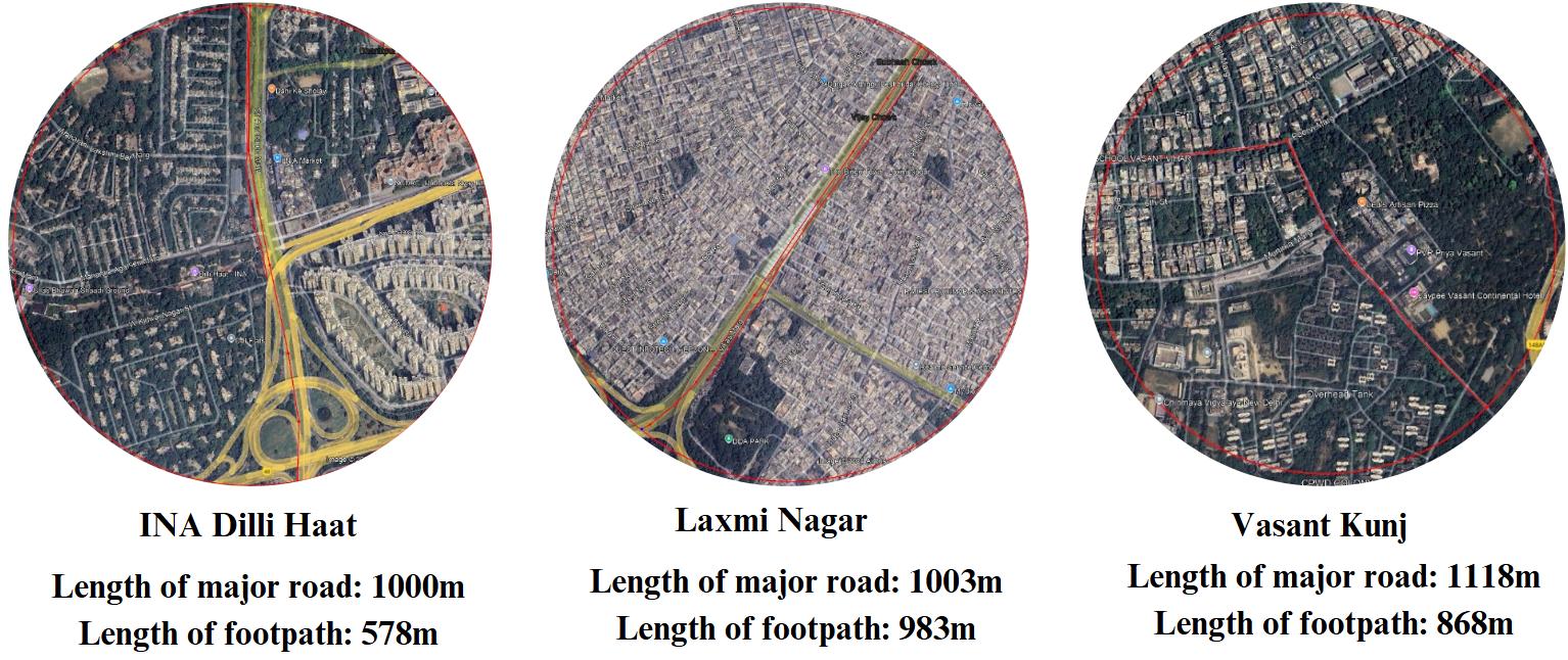
The case studies focus on analyzing the walkability index of three popular as well as dense locations of Delhi-INA Dilli Haat(South), Laxmi Nagar(East), and Vasant Kunj(South-West) These areas have been selected for their unique urban characteristics, population densities, and proximity to metro stations, making them suitable for a 15-minute city model assessment
Objective of this study is To evaluate pedestrian accessibility and safety within a 500-meter radius of the metro stations at INA Dilli Haat, Laxmi Nagar, and Vasant Kunj; To calculate the walkability index for each location based on the Ministry of Urban Development (MOUD) guidelines and; To identify the existing challenges and suggest improvements for pedestrian facilities.
The study areas were selected on the basis of: proximity to metro stations (within a 500-meter radius); variation in population density and; land use and accessibility and safety for pedestrians in high-traffic areas The tools used for data collection & survey are as mentioned: Pedestrian surveys and observations on footpath width, obstructions, and safety facilities; Photographic Documentation: To capture existing conditions of pedestrian pathways, footpaths, and surrounding environments and; GIS Mapping: For precise measurement of distances from metro stations and footpath lengths.
6.1.2
Significance of Selected Locations
● INA Dilli Haat: Known for its vibrant market and cultural center, frequented by both locals and tourists, creating a heavy footfall area
● Laxmi Nagar: A densely populated commercial and residential hub with high pedestrian and vehicular traffic.
● Vasant Kunj: A mixed-use area encompassing residential complexes, shopping malls, and educational institutions, creating varied pedestrian needs.
6.3.1
INA Dilli Haat
INA Dilli Haat is a well-known cultural and commercial center located in South Delhi, characterized by its vibrant marketplace offering handicrafts, cuisine, and cultural exhibitions. This area draws a diverse crowd, including residents, tourists, and daily commuters. The high pedestrian traffic due to its proximity to the INA Metro Station makes it an ideal site to assess pedestrian infrastructure needs.
Current Conditions:
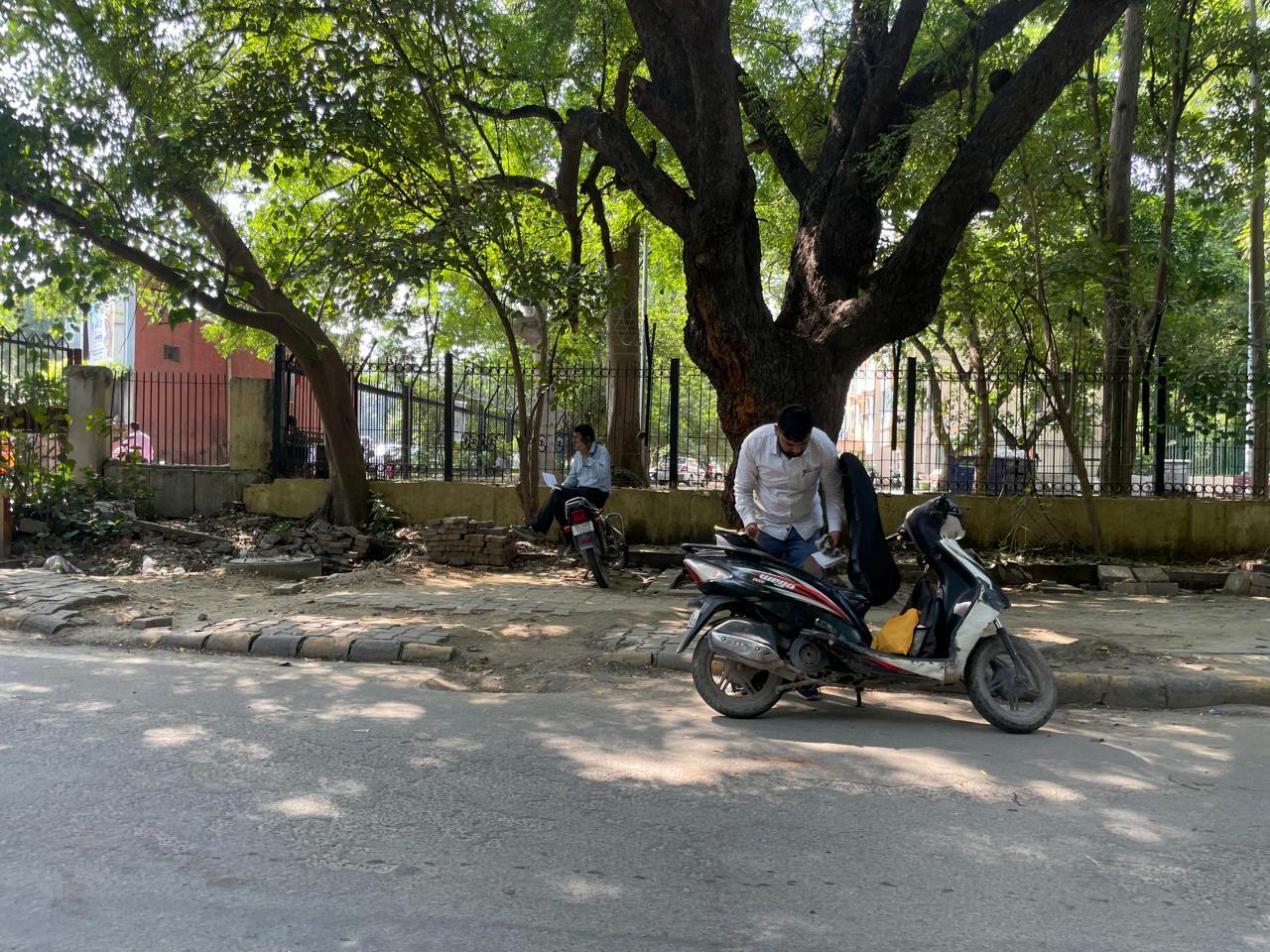
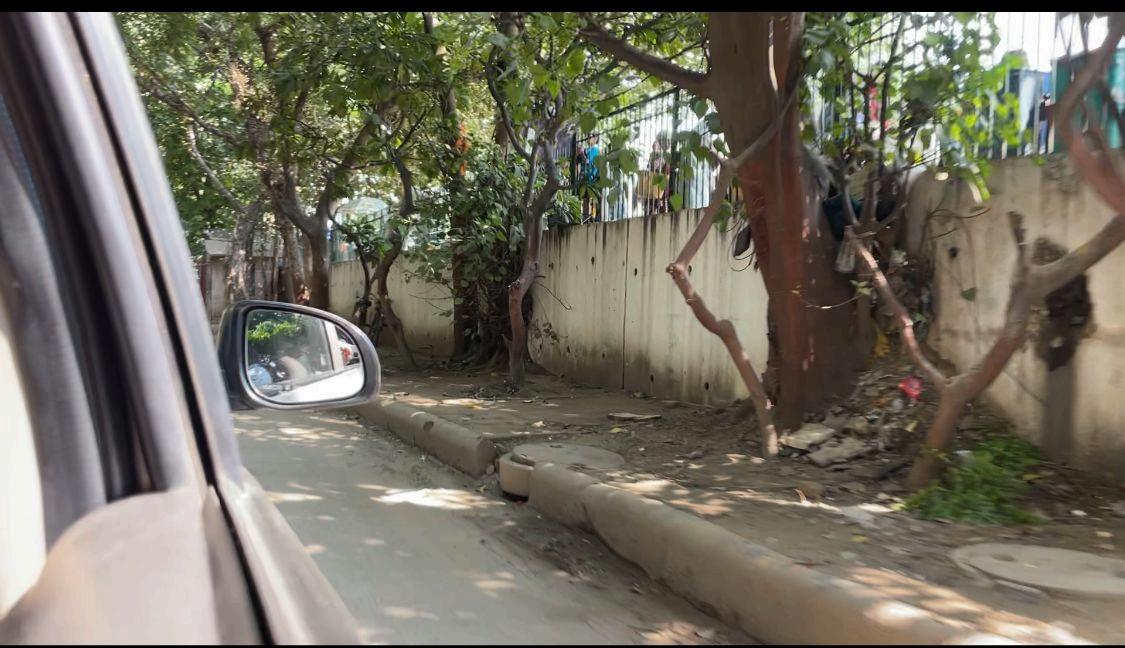
● Footpath Design: Pathways around INA Dilli Haat vary in width, often narrowing near market entries and crowded intersections.The pathways are meant to be used by the visiting public and small-scale vendors but are often obstructed by temporary stalls, resulting in overcrowding
● Safety and Accessibility: The few marked pedestrian crossings are compromised in some places due to the absence of sidewalks. High-traffic areas could consequently pose a risk to pedestrian safety. Lighting is poor in the area and could therefore create potential safety hazards, especially at night
● Environmental Challenges: With such outdoor exposure, pavements are often at the mercy of all weather conditions and suffer in surface quality and accessibility"
6.3.2 Laxmi Nagar
Laxmi Nagar is one of the busiest commercial and residential hubs in East Delhi It is known for its high population density and considerable pedestrian movement, serving as a nucleus for shopping, residential buildings, and educational institutions The metro station is said to be a crucial connection point for residents and commuters traveling across the city.
Current Situation:
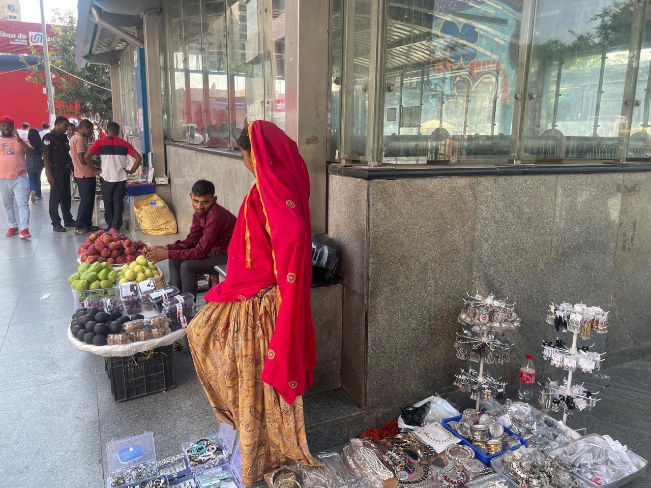
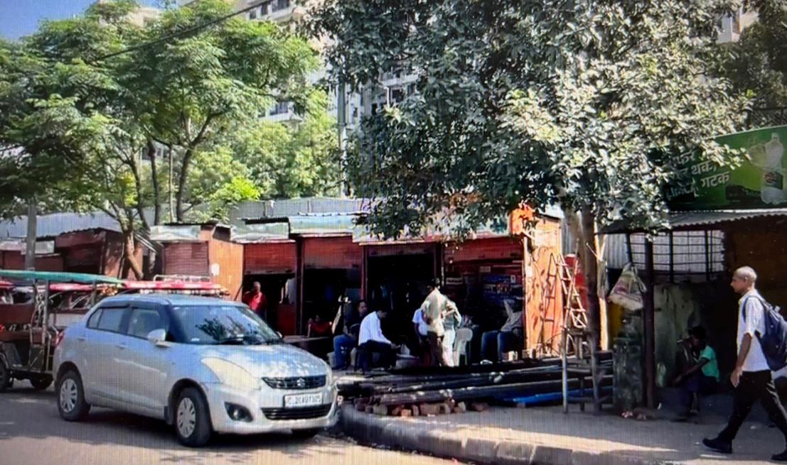
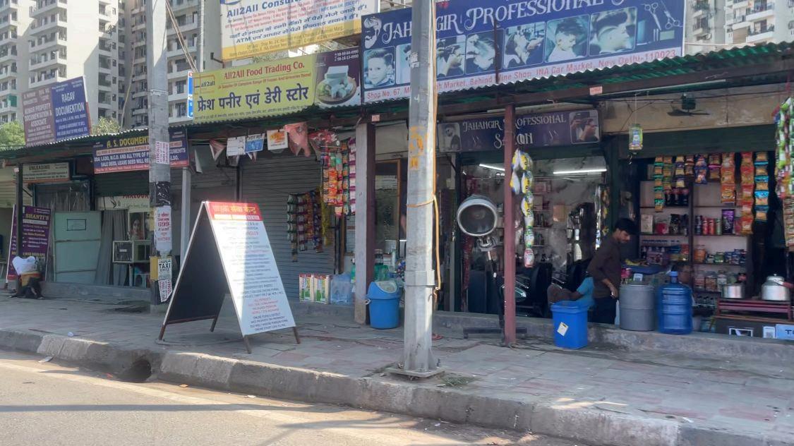
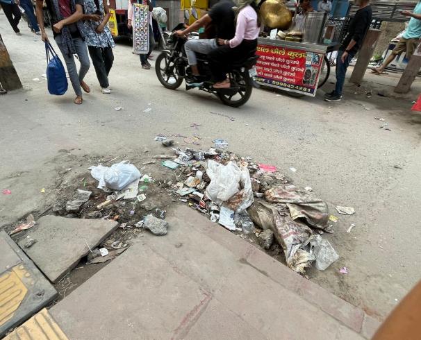
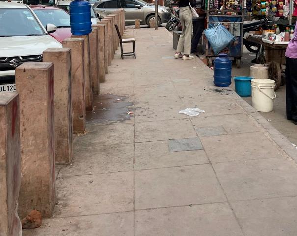
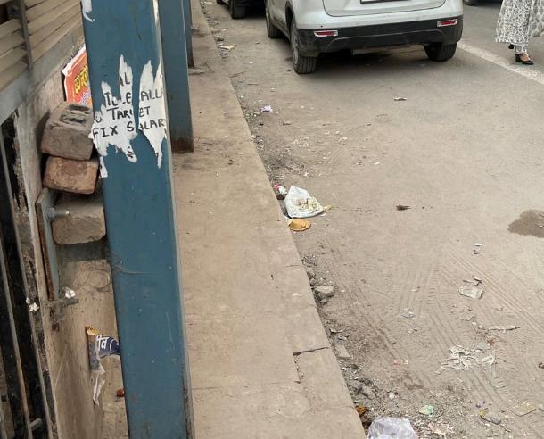
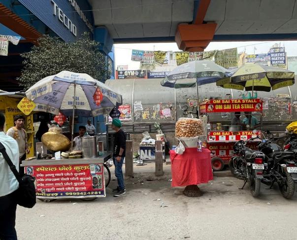
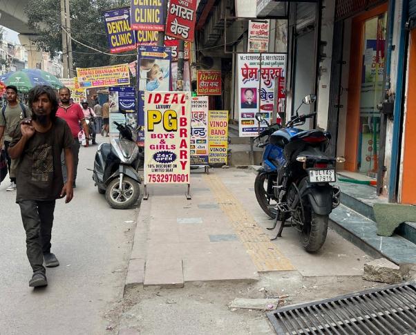
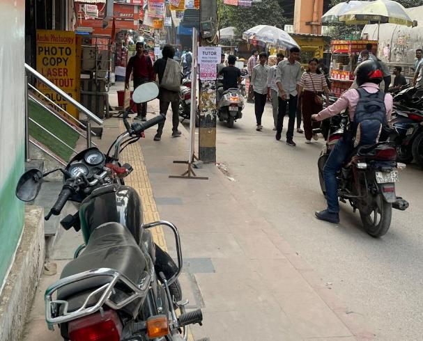
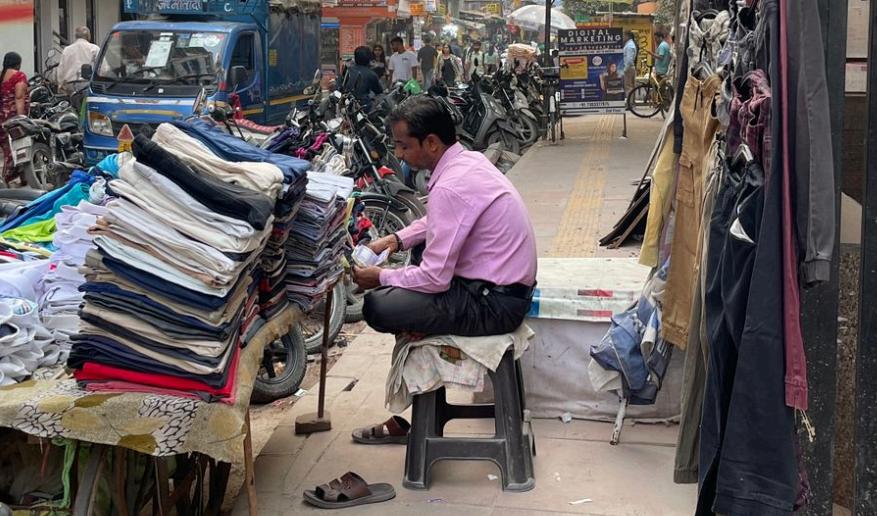
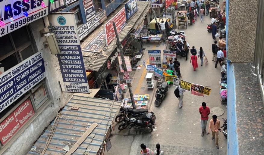
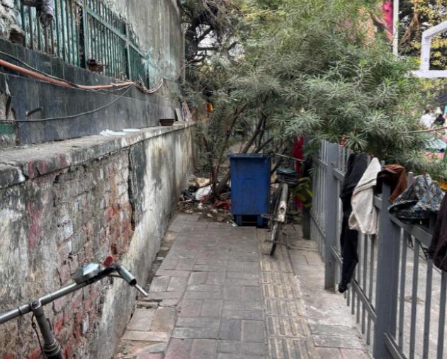
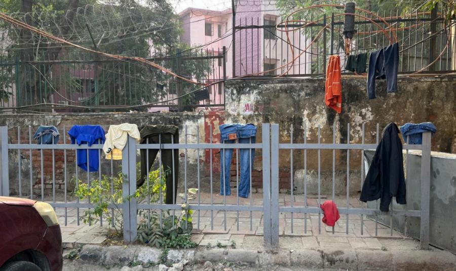
Footpath Constraints: Townships of Laxmi Nagar have narrow footpaths usually dotted with street vendors, illegal encroachments, and parked vehicles Pedestrians have to walk on the main road because of insufficient dedicated pathways.
Pedestrian Safety: The region is characterized by high vehicular-pedestrian interaction with the presence of poorly marked pedestrian crossings There is poor signage on the sidewalks, as well as the total lack of barricades, to provide protection from traffic, forcing pedestrians to be highly vulnerable
Infrastructure Maintenance: The quality of maintenance of the footpath is poor enough to present challenges for the elderly, children, and the weak and handicapped, due to cracks and debris on the surface
Poorly maintained pathways Encroachment by hawkers
Encroachment by shopkeepers Obstructions on footpaths
Figure 1. Current Conditions of INA Dilli Haat, photographed by the author, November 2024.
Encroachment by vendors
Obstructions on footpath
Encroachment on pathways
6.3.3 Vasant Kunj
Vasant Kunj is a major residential and commercial area in South Delhi. It has luxurious shopping centers, residential complexes, and various educational establishments catering to a wide spectrum of users. The metro station in Vasant Kunj is a bustling point of transition for students, residents, and shoppers alike
Current Conditions:
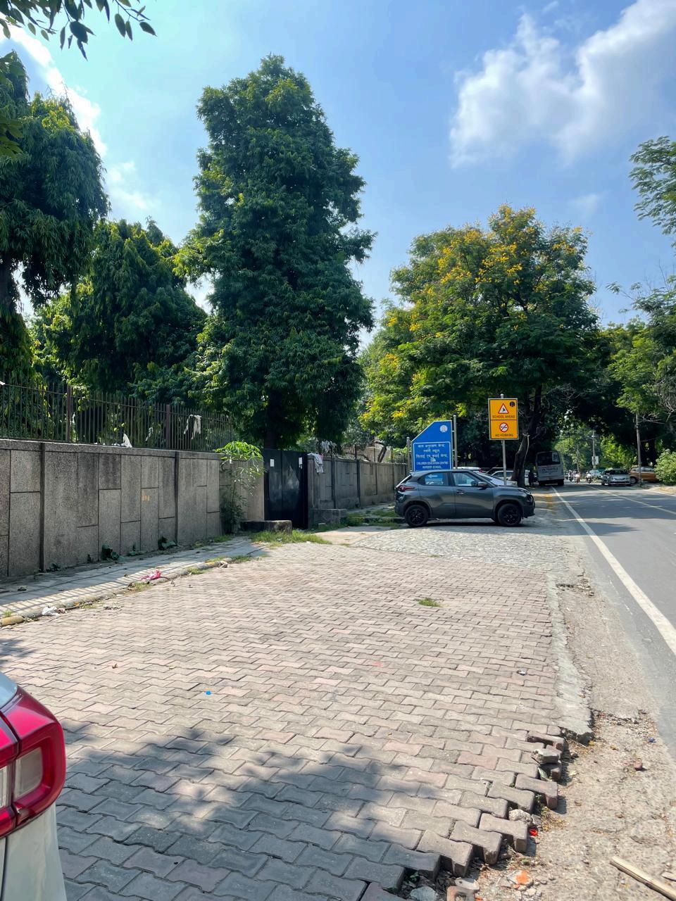
● Footpath Design and Width: Unlike the other areas, Vasant Kunj has relatively wider footpaths, but these are not uniformly distributed across the area Some pathways are
Figure 2. Current Conditions of Laxmi Nagar, photographed by the author, November 2024.
well-maintained, while others have inconsistent widths, affecting the overall pedestrian experience.
● Night-Time Illumination: While certain parts of Vasant Kunj have good lighting, others remain dimly lit, making them unsafe for pedestrians after dark.
● Traffic and Accessibility: Although footpaths are wide in some sections, the area lacks sufficient raised pedestrian crossings and traffic separators, leading to potential conflicts vehicles
6.4 Data Analysis and Calculation
6.4.1 Footpath Availability
The availability of footpaths will be calculated by measuring the total footpath length against the length of major roads in each 500-meter radius zone
No raised footpaths for pedestrians Constrained pathway width Insufficient Street lighting
Exposed pathways without Construction left dug up
Encroachment on pathways shade provision
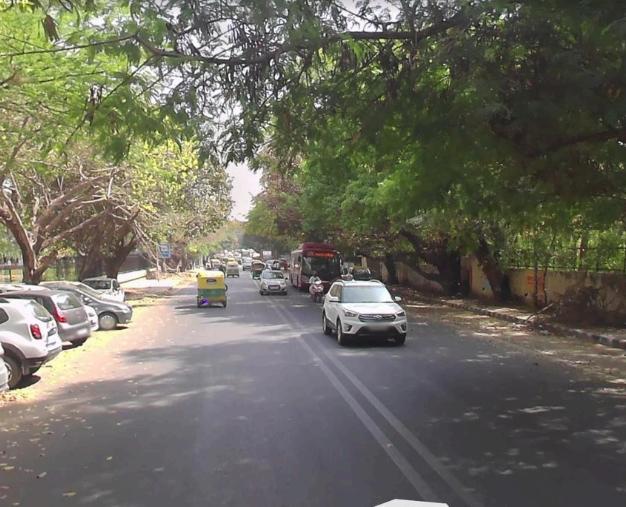
Figure 3. Current Conditions of Vasant Kunj, photographed by the author, November 2024 & Street view from Google Maps.
6.4.2 Pedestrian Facility Rating
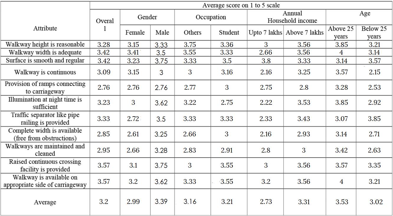
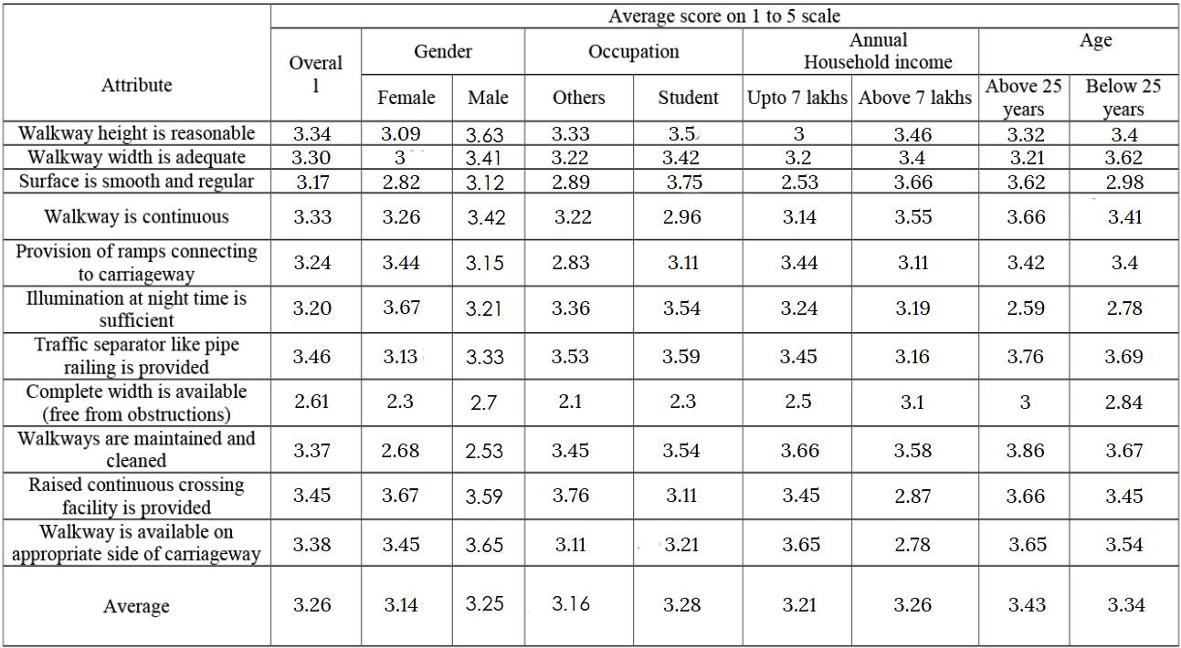
The pedestrian Facility rating is generated for all the three case study areas by using pedestrian facility form
Table 1. Laxmi Nagar(Survey-based average ratings for different pedestrian-related categories)
Table 2. INA Dilli Haat(Survey-based average ratings for different pedestrian-related categories)
Table 3. Vasant Kunj(Survey-based average ratings for different pedestrian-related categories)
6.4.3 Walkability Index
Where W1 and W2 are weights (assumed 50% for both)
Availability of footpath: Footpath length / Length of major roads in the city
Pedestrian Facility Rating: Score estimated based on opinion on available pedestrian facility
● INA Dilli Haat Walkability Index: ���������������������� ���������� = [ (0.5 x 1000/578) + (0.5 x 3.2/5)] = 1.18
● Laxmi Nagar Walkability Index: ���������������������� ���������� = [ (0.5 x 1003/983) + (0.5 x 2.54/5)] = 0.76
● Vasant Kunj Walkability Index: ���������������������� ���������� = [ (0 5 x 1118/868) + (0 5 x 3 26/5)] = 0.97
6.5 Walkability Index Results
● INA Dilli Haat: Relatively higher walkability index(1.18) with continuous pathways but frequent obstructions
● Laxmi Nagar: Low walkability index(0.76) resulting from encroachments and poor pedestrian infrastructure
● Vasant Kunj: High walkability(0.97), with well-maintained pathways but limited crossing facilities
6.6 Conclusion
The Walkability Index assessment highlights significant disparities in pedestrian infrastructure across Delhi’s urban areas, underscoring the urgent need for targeted interventions. While INA Dilli Haat and Vasant Kunj offer relatively better pedestrian facilities with well-maintained pathways and connectivity, they still face issues such as obstructions and inadequate crossing infrastructure On the other hand, Laxmi Nagar presents critical challenges, including encroachments, poorly maintained footpaths, and a lack of safe pedestrian crossings, making it one of the least walkable areas. These conditions not only hinder pedestrian movement but also discourage walking as a mode of transportation, forcing people to rely on motorized vehicles, thereby increasing congestion and pollution To address these challenges, strategic urban planning solutions must focus on removing obstructions from walkways, developing well-marked and signalized pedestrian crossings, and widening footpaths to accommodate high pedestrian traffic. Additionally, enforcing strict regulations against illegal encroachments, promoting non-motorized transport, and incorporating pedestrian-friendly designs in urban planning can significantly improve walkability A well-planned pedestrian infrastructure enhances safety, accessibility, and sustainability, making walking a convenient and attractive option for daily commutes Moreover, improved walkability contributes to healthier lifestyles, reduced traffic congestion, and lower environmental impact, fostering a more livable and environmentally friendly urban future. Investing in pedestrian infrastructure is not just a necessity but a step toward creating inclusive, safe, and vibrant cities that prioritize people over vehicles, ensuring a better quality of life for all urban dwellers