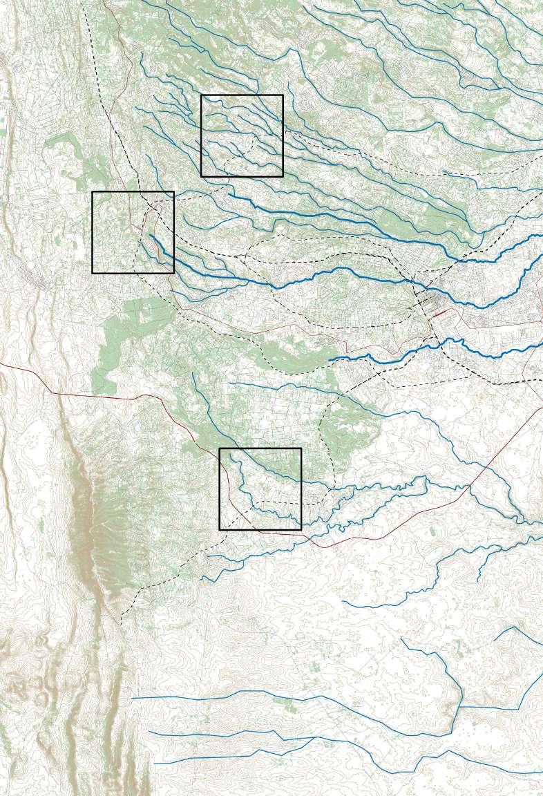
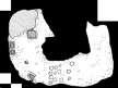
Ndenderu / Kikuyu / Ongata Rongai

Field WORK Shop


Water & Forest Urbanisms

2
Fieldwork Tutors & Contributors
David Njenga (TUK)
Jeroen Stevens (KUL)
Khalda El Jack (KUL)
Solam Mkhabela (WITS)
Professor Jason Mochache (TUK)
Dr. Lawrence Esho (TUK)
Brenda Kamande (Kiambu County)
Christine Muchiri (TUK)
Denis Abuya (Limuru Municipality)
James mworia (TUK)
Marion Mukolwe (JKUAT)
Fieldwork Groups
1
Daniela Carolina Garcia Rojas (KUL)
Daniel Matata Kithome (TUK)
Gaarith Williams (KUL)
Victor Obinge Ombati (TUK)
2
Loverina Cruz (KUL)
Md Rafiqui Islam (KUL)
Victor Omondi Ongor (TUK)
Winnie Amondi Sawo (TUK)
3
Grace Nyaguthi Kamweru (KUL)
Jepchumba Lagat (TUK)
Luis Alberto V. Carcamo (KUL)
Victor Daniel Kipkoech (TUK)
4
Darina Andreeva (KUL)
Elizabeth Agwa Onyango (TUK)
Felix Nzongo Wambua (TUK)
Rachid Garcia Elmosri (KUL)
5
Nyachiro Ongera Bob (TUK)
Sharmin Kabir Shimul (KUL)
Silvia Juliana Parra Pabon (KUL)
Victor Kiprop Chebli (TUK)
6
Benjamin Jonathan Baggot (KUL)
Ernest Ndungu Mwangi (TUK)
Nhat Ninh Khanh Nguyen (KUL)
7
Fahri Saud Abdala Reyes (KUL)
Karmen Janelle K. Hoge (KUL)
Paul Mumbo Musili (TUK)
8
Hagar Faggal (KUL)
Matimba Emmanuel Ngobeni (WITS)
Mohammed Padron Leruk (TUK)
Natalia Ricalde Miranda (KUL)
9
Beatrice Watetu Mwangi (TUK)
Emma Brecher (WITS)
Santiago Cortinez Albarracin (KUL)
Zeeshan javaid Ghani (KUL)
3
4
Site A Ndenderu Site B Kikuyu Site C Ongata Rongai
The Technical University of Kenya (TUK), University of Leuven (KUL, Belgium) and University of Witwatersrand (WITS, South Africa) collectively engaged in a twoweek Field Work Shop in the West of Nairobi. On the basis of interpretative cartography, the analytical work produced by the groups aim to discuss major challenges of urbanization and climate change in the particular areas of Ndenderu, Kikuyu and Ongata Rongai.
What is the contemporary design agenda for water and forest urbanism in these diverse landscapes facing rapid development?

5
Site A Ndenderu


Plan & Section Process Diagram Collage


Consumptive Landscapes


Typology


Land use in Ndenderu and its surroundings is defined by its topographical and administrative characteristics, where clear bordesions can be seen due to these phenomena. How do the topography and planning regulations influence the typology of housing, infrastructure, and land use? Annotated Plan & Section Typology Spatial disparity across valley system. Grace Kamweru (KUL), Luis Villadiego (KUL), Jepchumba Lagat (TUK), Victor Kipkoech (TUK). Nairobi Kenya SECTIONS 2 1 3 A-A’: Limuru Rd. Swale C-C’ Banana Town. Shops LANDSCAPE TYPOLOGIES FABRIC Farming Valley Urban Valley Urban Centre 3 2 1 Gentle slopes Few settlements Plantations Industries Steeper slopes Denser settlements Subsistent farms Fragmented plots Mixed use housing Linear development Gentle slopes Compact settlements Town setup Mixed use housing Radial development Process Diagram Typologies Kenya Sample 4: Banana Hill dryseason SupplycontinuousyHigherdensityreducestheabiltyforthegorund absorbwaterincreasingthechance flooding. New urban developmentPrivately owned boreholes Collage Typologies Kenya Ndenderu’s landscape is choreographed by steep valley slopes and river systems that structure agricultural activities. The interplay of the water and topography is crucial for the agricultural production of Ndenderu, influencing landscape appropriations and consumption patterns. How are natural landscape systems influencing consumptive landscape appropriations? Consumptive Landscapes Consuming Topography Loverina Cruz (KUL), Md Rafiqul Islam (KUL), Winnie Amondi Sawo (TUK), Victor Omondi Ongor (TUK) Kenya Wells (depth 80-120ft) Pits (depth 10-15ft)_ Explaining groundwater, wells, boreholes, pits and septic tanks Stalk plants 1829m Limuru Road Ndenderu BananaHill Ndenderu’s natural landscape has catered for a rich diversity of agricultural uses. How are different inhabitants working these lands, appropriating and re-creating the valleys and slopes? Ndenderu Process diagram Consumptive Landscapes (Re)working the land Kabir Shimul Sharmin (KUL), Nyachiro Bob (TUK), Kiprop Victor (TUK), Parra Silvia (KUL) Kenya Woman between 20 50 years old C a p pe o a d ap o ito PROCESS OF LANDSCAPE APPROPRIATION scarcity forest footprint Land colonization for farming Highlands for farming Increase of Napier grass plantations Small scale farming corrugated sheats Napier grass Large scale farming Causes of the evolution types of consumption Consequences New massive housing Decrease in horticulture Urban growth Anthony Old Shopkeeper Farmer Farmer Kinyanjui Wanjiru Chalo Ndugu Njoroge Gitau Kageshe Naftali Sharon Rufus George Samuel-Housing improvement bigger houses Densification the foot print Types of land approriation Rapid Urbanization has engulfed Ndenderu area, threatening indigenous landscape appropriations and practices. Increasing densifiction is probably the biggest casualty of the rapid landscape transformations. How are current modes of human consumption of nature shaping (in)balanced landscapes? Collage Consumptive Landscapes Where is the balance? Faggal Hagar (KUL), Leruk Mohammed (TUK), Ngobeni Matimba (WITS), Recalde Natalia (KUL) Kenya While rapid urbanization in Ndenderu has critically reduced rural activities, individual agricultural and economic actions can positively impact local and territorial contexts, while even interacting with the global market. How does a particular plot of land in Banana Hill embody multilayered productive landscapes and macro-networks? Productive Landscapes A farmer’s productive land García-Rojas Daniela (KUL), Williams Gaarith (KUL), Matata Daniel (TUK), Obinge Victor(TUK) Kenya SE F-C N UMPTON GLO MARKET MO L Y NFRASTRUCTUR ANDURBANZA O Process Diagram Productive Landscapes Water prints Agwa Elizabeth (TUK), Andreeva Darina (KUL), Garcia Elmosri Rachid (KUL), Wambua Felix (TUK) Kenya Ndenderu is a peculiar territory of dispersed river valleys, directly correlating to anthropogenic cycles of use and appropriation. While wider valleys seem to host more centralized supply systems of reticulation pipes and springs, narrow ones rely more on decentralized boreholes and open waterways. How do these diverse water systems intertwine and interact? The Western Bypass construction comes with heavy land speculation, while providing new opportunities for connecting and integrating Ndenderu to the city of Nairobi. The new linkage also allows to connect roadside markets with the entire market network of Nairobi. What kind of market network could the Western Bypass through the Ndenderu-Wangige valley system establish? Collage Productive Landscapes Western Bypass market relations Fahri Abdala-Reyes (KUL), Karmen Hoge (KUL), Paul Mumbo Musili (TUK) Kenya lorry.transportany BananaHill Wangige Ndenderu Nairobi Kibagare bypasswillhelpmy Uganda VictoriaLake needbetterroad” 1930m
Productive Landscapes
How the buildings face the streets? Understanding the relationship between facades and people Kikuyu Annotated Plan & Section Typology Streets-Gates-Users Agwa Elizabeth (TUK), Andreeva Darina (KUL), Garcia Elmosri Rachid (KUL), Wambua Felix (TUK) Nai obi Kenya As the Kikuyu landscape continues to be subdivided by large infrastructural projects, it has shaped an archipelago of mutating urban morphologies and housing typologies, each closely bound up with its distinct placement in the landscape. How can new flexible forms of urbanization be designed to accommodate this continuously changing urban landscape? Kikuyu Process Diagram Typologies Mutating typologies Fahri Abdala-Reyes (KUL), Karmen Hoge (KUL), Paul Mumbo Musili (TUK) Nairobi Kenya historical evolution of the housing typology “thebypassisgood andnowwanttoenjoymy flatandrentoutrooms landafterindependece” amongmybrothersand luxary villas in large plot mixed-use cluster buildings multi-dwelling units large plot agricultural bungalow rural bungalow evolution of urbanization along major mobility lines A104 Kikuyu Rd Railway 1900s 2020 The rapid urbanization of Kikuyu area has been framed by the construction of new mobility networks that heavily contrast with previous rural and peri-urban roads. Which new building typologies have and can emerge along Kikuyu’s rapidly densifying infrastructural systems? Kikuyu Collage Typology Mobility typologies García-Rojas Daniela (KUL), Williams Gaarith (KUL), Matata Daniel (TUK), Obinge Victor (TUK) Nairobi Kenya Half-complete development Parasitic stall Remoteinvestmentdevelopments New peri-urban domicile The Ondiri Wetland is known to many as an “underground water tank” making it an important water source to dependents such as adjacent industries, Kikuyu Springs and Nairobi City. How can new strategies be implemented in and arround the Ondiri Wetland to counter its current perception and use as a dumping ground and free water source, to one that is preserved, recognised and celebrated for its ecological importance Kikuyu Annotated Plan & Section Consumptive Landscapes A withering wetland Benjamin Baggott (KUL), Khanh Nguyen (KUL), Ernest Ndungu (TUK) Nairobi Kenya Indigenous tree planting Cabbage Coriander Broad leaf Ficus tree Grey HeronThe water consumption patterns through natural source pumping, boreholes and municipal pipelines affect community relationships and value associations in the water catchment and distribution areas. As the town environs continue to grow and their need for water increases, how can these consumption patterns be spatially manipued to enhance social relationships? Kikuyu Process Diagram Consumptive Landscapes Water communities Emma Brecher (WITS), Zeeshan Ghani (KUL), Santiago Cortinez (KUL), Beatrice Mwangi (TUK) Nairobi Kenya KIKUYU SPRINGS & NAIROBI WATER PROJECT irrigate supplied service communal problem solving post damage process delivered controled self help organizations growth removed Kikuyu Spring DISTRIBUTION AREA CATCHMENT AREA managed Urban development in Kikuyu sub-county is gradually threatening the limited forest resources in the area. Housing, new roads, railways expansion and other infrastructural development has led to a significant deHow do we create a balance between human development activities and existing biodiversity? Kikuyu Collage Consumptive Landscapes Forest Consumption Grace Kamweru (KUL), Luis Villadiego (KUL), Jepchumba Lagat (TUK), Victor Kipkoech (TUK). Nairobi Kenya Gacuthi and Bama Forests Sigona golf club Ondiri swamp Kikuyu springs Nderi farms RURAL URBAN The green house business of Kikuyu, both subsistence and industrial, has exponentially grown over the last years due to decreasing land sizes and reduced returns on open farmlands, causing environmental deterioration of natural water resources. What strategies need to be developed to create more environmentally friendly farming techniques across the Kikuyu landscape? Kikuyu Productive Landscapes Ecology or economy? Nairobi Kenya Kabir Shimul Sharmin (KUL), Nyachiro Bob (TUK), Kiprop Victor (TUK), Parra Silvia (KUL) Collage outlet AGRICULTURE water extraction pesticides decrease of EUCALYPTUS PLANTATION AGRICULTURE Site B Kikuyu Productive Landscapes Consumptive Landscapes Typology Plan & Section Process Diagram Collage 6
Plan & Section Process Diagram Collage


Productive Landscapes


Consumptive Landscapes


Typology


Interweaving natural and man-made structuring elements have informed different settlement morphologies across the multiple lanscapes of Ongata Rongai. As the city continues to expand, how can this barcode of morphologies and typologies, bound by rivers and roads, inform different settlement growth patterns? Ongata Rongai Annotated Plan & Section Typology Urban barcode Faggal Hagar (KUL), Leruk Mohammed (TUK), Ngobeni Matimba (WITS), Recalde Natalia (KUL) Kenya With the construction of new road and railway infrastructures, Ongata Rongai is facing acute conflicts between urban sprawl and indigenous Maasai pastoral practices. How have land use and cover su as rangelands, croplands, forests, riverines, bare grounds and built up sites, transformed? Which adaptive practices have these mutations provoked? Ongata Rongai Process Diagram Typology Mutating landscapes of use and coverage Loverina Cruz (KUL), Md Rafiqul Islam (KUL), Winnie Amondi Sawo (TUK), Victor Omondi Ongor (TUK) Kenya Make sure to include a scale annotation, scale bar & north arrow 1985 20 30 50 60 80 90 100 % OF AREA COVER 0 BUILT-UP immigrants adapting crop production 1985 LAND USE CHANGE (1985-present) Conflicting interest of urban sprawl and pastoral practices LAND COVER CHANGE (1985-present) LEGEND Massive road and railway infrastructures are currently superimposed on the formerly rural landscapes of Ongata Rongai. How is this vast infrastructural metamorphosis impacting its rural-urban surroundings? How is it radically transforming the natural and built landscape of Ongata Rongai? Kabir Shimul Sharmin (KUL), Nyachiro Bob (TUK), Kiprop Victor (TUK), Parra Silvia (KUL) Throughout its swift urbanization history, Ongata Rongai has accumulated cultural and social diversity. How is this co-existence of various ethnic groups orchestrated and accommodated by the urban landscape? Which spaces, activities and services bring people together and encourage them to coexist? Ongata Rongai Consumptive Landscapes An emergent cosmopolis? Fahri Abdala-Reyes (KUL), Karmen Hoge (KUL), Paul Mumbo Musili (TUK) Kenya interiorofthecampus Kware,the “long-city” Kiserian market, livestockas junction TheMaasaipeopleselllivestock fromthelivestock TheMaasaipeoplearrangeKikuyu´sbutcheries –fromacrossKenyalearn Langata,the “non-city” MostareasinLangataareprivate. Peoplegather privateareasandthe Shoppingcenter Langata placeofpeace.Whilethere OleKassasi,the noncentrality –Ongata Rongai presents itself as a rapidly evolving, half-complete settlement, where conventional classification categories proveequate when compared to actual land use. What is the relationship between localized practices, land speculation and infrastructure development over time? What complexities emerge from overlapping logics of formal and informal development? Ongata Rongai Process Diagram Consumptive Landscapes Scrambling for Rongai García-Rojas Daniela (KUL), Williams Gaarith (KUL), Matata Daniel (TUK), Obinge Victor(TUK) Kenya Single esidental arming lace for worship Ligh industrty Schools -2009 -2019 Ongata Rongai Consumptive Landscapes Collage Dead Ends Agwa Elizabeth (TUK), Andreeva Darina (KUL), Garcia Elmosri Rachid (KUL), Wambua Felix (TUK) Kenya The urbanized valley of Ongata Rongai, home to the Mbagathi river, is replete of dead ends, abrupt enclosures, fences and barriers. How has this patchwork of dead ends emerged over time? And what challenges does it pose for future urban development and design? Nairobi City Kiserian Market KwareMarket Hotel cluster/ National Park The market network economies of Kajiado County have different flo structures defined by the relationship between trader, product and stakeholders within the local, national and international marke What are the different production network systems affecting markets in the Kajiado County stretching from the Ngong Hills to Nairobi? Ongata Rongai Productive Landscapes Flows of Production Emma Brecher (WITS), Zeeshan Ghani (KUL), Santiago Cortinez (KUL), Beatrice Mwangi (TUK) Kenya Section Kware market Hotels market Process Diagram Productive Landscapes Water prints Agwa Elizabeth (TUK), Andreeva Darina (KUL), Garcia Elmosri Rachid (KUL), Wambua Felix (TUK) Kenya Ndenderu is peculiar territory of dispersed river valleys, directly correlating to anthropogenic cycles of use and appropriation. While wider valleys seem to host more centralized supply systems of reticulation pipes and springs, narrow ones rely more on decentralized boreholes and open waterways. How do these diverse water systems intertwine and interact? What are the economic and environmental factors that led to the rapid urbanisation of Ongata Rongai? Why did this result in an urban environment that is highly fragmented and unequal in terms of access to land and resources? Ongata Rongai Collage Productive Landscapes Disjointed landscape Benjamin Baggott (KUL), Khanh Nguyen (KUL), Ernest Ndungu (TUK) Kenya Broken landscapes, crucial infrastructure Peri-urbanisation, fragmented rural and urban landscapes Rivers refuge? geological break between contrasting built environments Densification: Agricultural plots are eaten up by apartment blocks Lifeline to Ongata Rongai: Commercial and connection strip Made in where? Endless markets selling imported goods Slum: diverse community fighting for an entry into the econo my Educational buffer: Schools provide grazing space and brea between the wealthy areas the north Agricultural land with variety crops. 10 Gated upmarket residential communities with improved infrastructure and services 11 Tourism based economy, exclusive hotels, restaurants and manor like estates. The economy of the city of Ongata Rongai depends largely on the meat market and the construction industry. Nevertheless, urban development is gradually replacing pasturelands, which results in the permanence of informal livestock pens within the city and reduced grasslands. In what way can space be redistributed to reorganize informality in the construction and the meat industries of Ongata Rongai? Ongata Rongai Process Diagram Productive Landscapes Constructed meat market Grace Kamweru (KUL), Luis Villadiego (KUL), Jepchumba Lagat (TUK), Victor Kipkoech (TUK). Nairobi Kenya 1:2300
Site C Ongata Rongai
7
Site A Ndenderu

8

9
© Silvia Parra
Productive Landscapes

10
© Sharmin Shimul
MOBILITYINFRASTRUCTURE ANDURBANIZATION

SELF-CONSUMPTION GLOBALMARKET


A farmer’s productive land

While rapid urbanization in Ndenderu has critically reduced rural activities, individual agricultural and economic actions can positively impact local and territorial contexts, while even interacting with the global market. How does a particular plot of land in Banana Hill embody multilayered productive landscapes and macro-networks?
 Ndenderu Annotated Plan & Section Productive Landscapes
García-Rojas Daniela (KUL), Williams Gaarith (KUL), Matata Daniel (TUK), Obinge Victor(TUK)
Nairobi Kenya
Ndenderu Annotated Plan & Section Productive Landscapes
García-Rojas Daniela (KUL), Williams Gaarith (KUL), Matata Daniel (TUK), Obinge Victor(TUK)
Nairobi Kenya
11
Water prints


Ndenderu is a peculiar territory of dispersed river valleys, directly correlating to anthropogenic cycles of use and appropriation. While wider valleys seem to host more centralized supply systems of reticulation pipes and springs, narrow ones rely more on decentralized boreholes and open waterways. How do these diverse water systems intertwine and interact?


 Ndender u
Process Diagram
Productive Landscapes
Agwa Elizabeth (TUK), Andreeva Darina (KUL), Garcia Elmosri Rachid (KUL), Wambua Felix (TUK)
Nairobi Kenya
Ndender u
Process Diagram
Productive Landscapes
Agwa Elizabeth (TUK), Andreeva Darina (KUL), Garcia Elmosri Rachid (KUL), Wambua Felix (TUK)
Nairobi Kenya
12
“anyone can hire the lorry. transport any food or construction material from the highlands to sell in the market... ”

“... the melons that sell come from far away”
“I sell the extra food that grow in my backyard (...) don´t know where will sell my products once the bypass is built”
“the bypass is the best thing that could have happened. The movement of my milk, eggs and chicken will be easier. We need a better road”
“We use the road to go to Church. On our way home, we by food on the

“At my tree nursery, took advantage of the streams to water my plants... the cars stop here to buy plants. The bypass will help my
“when there is traffic jam, it takes 3 hours by matatu to get the products in Nairobi”
Ndenderu Collage
Nairobi Kenya
Productive Landscapes


Western Bypass market relations
The Western Bypass construction comes with heavy land speculation, while providing new opportunities for connecting and integrating Ndenderu to the city of Nairobi. The new linkage also allows to connect roadside markets with the entire market network of Nairobi. What kind of market network could the Western Bypass through the Ndenderu-Wangige valley system establish?
Fahri Abdala-Reyes (KUL), Karmen Hoge (KUL), Paul Mumbo Musili (TUK)
Ndenderu tomatoes local residents fish 3hr Nairobi Kibagare
Banana Hill Wangige
Uganda Victoria Lake bananas local production
1910m 1890m 1840m local production kale cassava carrots 1930m mangos 700 m 13
Consumptive Landscapes

14
© Benjamin Baggot
Ndenderu Annotated Plan & Section Consumptive Landscapes


Consuming Topography
Ndenderu’s landscape is choreographed by steep valley slopes and river systems that structure agricultural activities. The interplay of the water and topography is crucial for the agricultural production of Ndenderu, influencing landscape appropriations and consumption patterns. How are natural landscape systems influencing consumptive landscape appropriations?
Loverina Cruz (KUL), Md Rafiqul Islam (KUL), Winnie Amondi Sawo (TUK), Victor Omondi Ongor (TUK)


Boreholes (depth 40-50ft) Wells (depth 80-120ft) Pits (depth 10-15ft)_
Plots River Roads Crops Pit Latrines Boreholes Seedlings Stalk plants Eucalyptus 1901m 1829m 1854m 1812m Water table up to 300m
BananaHill 15
Nairobi Kenya
Explaining groundwater, wells, boreholes, pits and septic tanks
Limuru Road Ndenderu
Typesofland appropriation
Ndenderu

(Re)working the land


Consumptive Landscapes


PROCESS OF

Ndenderu’s natural landscape has catered for a rich diversity of agricultural uses. How are different inhabitants working these lands, appropriating and re-creating the valleys and slopes?


Kabir Shimul Sharmin (KUL), Nyachiro Bob (TUK), Kiprop Victor (TUK), Parra Silvia (KUL)


Process diagram


Nairobi Kenya Woman between 20 - 50 years old Senior woman Senior man Man between 20 - 50 years old C cape
LANDSCAPE
Decrease of forest footprint Land colonization for farming Houses in corrugated sheats Ecualyptos Napier grass Wetland Corn Wetlands for farming Affordable prices for rent Not rentable businness like in the past Nearby Banana hill Highlands for farming Afordable prices for rent Safe neighborhood Increase of Napier grass plantations
scale farming Houses in corrugated sheats Napier grass Corn
scale farming Causes of the evolution of types of consumption
APPROPRIATION Water scarcity
Small
Large
massive housing
in horticulture Greenhouses Deforestation Urban growth Anthony Occupation Time in settlement Farmland posession Perception of the site Recent Recent Recent Recent Old Old Old Old Old Old Old Old Old Recent Old Old Old Old Old Old Old Boda-boda rider Shopkeeper Housewife Housewife Retired Civil Servant Security officer Stays at home Manual Labourer Farmer Farmer Farmer Farmer Farmer Farmer Farmer Farmer Farmer Manual Labourer Businessman Taxi driver Kinyanjui Monica Charles Wanjiru Chalo Ndugu Wanjiku Njoroge Tabitha Gitau Kageshe John Naftali Sharon Grace Rufus Esther George John B Samuel 1 2 3 4 5 6 7 8 9 10 11 12 13 14 15 16 17 18 19 20 21+ + + + + + + + + + + + + + + + + + +Housing improvement Better materials, bigger houses Napier grass Chickens Corn New high density housing Densification of the foot print Inhabitants interviews Types of land approriation Water Forest Foot print 16
Consequences New
Decrease
Where is the balance?
Rapid Urbanization has engulfed Ndenderu area, threatening indigenous landscape appropriations and practices. Increasing densification is probably the biggest casualty of the rapid landscape transformations. How are current modes of human consumption of nature shaping (in)balanced landscapes?


 Ndenderu Collage Consumptive Landscapes
Faggal Hagar (KUL), Leruk Mohammed (TUK), Ngobeni Matimba (WITS), Recalde Natalia (KUL)
Ndenderu Collage Consumptive Landscapes
Faggal Hagar (KUL), Leruk Mohammed (TUK), Ngobeni Matimba (WITS), Recalde Natalia (KUL)
17
Nairobi Kenya

Typologies
18
© Jeroen Stevens
Spatial disparity across valley system.

Land use in Ndenderu and its surroundings is defined by its topographical and administrative characteristics, where clear border divisions can be seen due to these phenomena. How do the topography and planning regulations influence the typology of housing, infrastructure, and land use?


Ndenderu Annotated Plan & Section Typology
Nairobi Kenya SECTIONS 2 1 3 A-A’: Limuru Rd. Tea farms - factories Green Houses Swale Road Residential Subsistence Farming Swale B-B’ - Gitaru Rd. Residential Road Powerline Swale Residential C-C’ - Banana Town. Road Commercial Shops Football pitch Mixed use N LANDSCAPE TYPOLOGIES Limuru Rd. FABRIC 1:12000 Farming Valley Urban Valley Urban Centre 3 2 1 Gentle slopes Few settlements Plantations Industries Steeper slopes Denser settlements Subsistent farms Fragmented plots Mixed use housing Linear development Gentle slopes Compact settlements Town setup Mixed use housing Radial development 19
Grace Kamweru (KUL), Luis Villadiego (KUL), Jepchumba Lagat (TUK), Victor Kipkoech (TUK).
Typologies


Ndenderu Process

Water equity?

The privatisation of water supply through boreholes has given the majority of the population access to a reliable water source. However, has monopolisation and privatisation of water opened up new avenues for both environmental and social abuse?


Diagram
Benjamin Baggott (KUL), Khanh Nguyen (KUL), Ernest Ndungu (TUK)
Nairobi Kenya
Sample 3: Mr. Sam (1.1924o S, 36.7349oE)
Ground water shrink Contaminate the water resources Havest Rainwater Irrigate Irrigate Flooding Mixed farm (banana tree, corn, kale,...) Toilets Households Tenants Arrowroot Supply in dry season Supply continuousy Households with private borehole Households with private borehole Households with water supply from municipality Households with rain water supply Boreholes Depleted Groundwater Reservers
Sample 4: Banana Hill
Higher population results in an increased pressure on groundwater supply Privately owned municipality linked reservoirs New urban development Rather than spending time on education or entering the economy, many young people are forced to spend a large portion of their day collecting water. Municipal water is only connected to households and businesses that can afford it. Privately owned boreholes Surface water shrink 20
Higherdensityreducestheabiltyforthegorundto absorbwaterincreasingthechanceofflooding.
Transitions of appropriation


Different patterns of landscape appropriation are affecting the thresholds between individual properties and the common territory. Regarding the linear settlement structures of the area, how do diverse thresholds impact socio-economic associations in the urbanizing valleys of Ndenderu?


 Ndenderu Collage Typologies
Emma Brecher (WITS), Zeeshan Ghani (KUL), Santiago Cortinez (KUL), Beatrice Mwangi (TUK)
Ndenderu Collage Typologies
Emma Brecher (WITS), Zeeshan Ghani (KUL), Santiago Cortinez (KUL), Beatrice Mwangi (TUK)
21
Nairobi Kenya
Site B Kikuyu

22

23
© Jeroen Stevens
Productive Landscapes

24
© Benjamin Baggot
Ecology or economy?

The green house business of Kikuyu, both subsistence and industrial, has exponentially grown over the last years due to decreasing land sizes and reduced returns on open farmlands, causing environmental deterioration of natural water resources. What strategies need to be developed to create more environmentally friendly farming techniques across the Kikuyu landscape?
 Kikuyu
Annotated Plan & Section Productive Landscapes
Nairobi Kenya
Kikuyu
Annotated Plan & Section Productive Landscapes
Nairobi Kenya
25
Kabir Shimul Sharmin (KUL), Nyachiro Bob (TUK), Kiprop Victor (TUK), Parra Silvia (KUL)


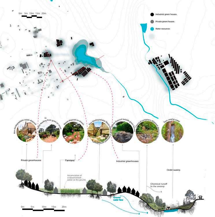
ONDIRI SWAMP KIKUYU SPRINGS RAIN WATER GREEN HOUSES water pumps extraction pesticides VETIVER GRASS FRIENDS OF ONDIRI WETLAND CONSERVATION BAMBOO INDUSTRIES main source cleans water treatment plant KIKUYU WATER COMPANY LTD UNDERGROUND LAKE outlet NYONGARA RIVER planting ACADEMIC CLUSTER pollution HOUSING SWAMP AGRICULTURE AGRICULTURE HOSPITALS MOBILITY water provision septic tank sewer system underground water pollution GRAZING KABETE NAIROBI GITARU STEEL ROLLING KIDFARMACO BARANIKI supplies 95.000 water extraction pesticides waste water water provision forest microclimate retreat space cattle provides manure fertilize natural wetland plants decrease of water table decrease of water table water extraction to build insfrastructure EUCALYPTUS PLANTATION water pumps extraction pesticides 100 500 1000 GREEN HOUSES AGRICULTURE 26
Industrial Ecosystem

Growing industry in and around Kikuyu is putting profound pressure on natural reservoirs, water towers and landscapes of the area. How do these industries produce a new urban landscape, attracting new towns, developing centralities, and establishing economic circularity? How could industrial production be designed and controlled to restore and maintain the area’s ecological integrity?
Ongata Rongai Collage
Productive Landscapes
Loverina Cruz (KUL), Md Rafiqul Islam (KUL), Winnie Amondi Sawo (TUK), Victor Omondi Ongor (TUK)
27
Nairobi Kenya
Consumptive Landscapes

28
© Sharmin Shimul
trees Napier Grass - 2 Short Wetland Grass
Cyperus Papyrus Sawgrass Bulrush Invasive Trees
Green houses -1
Damaged green houses Housing +2 Storey Buildings
Pumping station - 4
Antibiotic waste
Fever tree - Baglafecht Weaver


Yellow wood tree - Variable Sunbird
Acacia Tortilis - Red Collard Widow bird

Broad leaf Ficus tree - Grey Heron

Croton Megolocarpus - Paradise Fly Catcher
Kikuyu
A withering wetland

Consumptive Landscapes
Annotated Plan & Section

The Ondiri Wetland is known to many as an “underground water tank” making it an important water source to dependents such as adjacent industries, Kikuyu Springs and Nairobi City. How can new strategies be implemented in and arround the Ondiri Wetland to counter its current perception and use as a dumping ground and free water source, to one that is preserved, recognised and celebrated for its ecological importance
Benjamin Baggott (KUL), Khanh Nguyen (KUL), Ernest Ndungu (TUK)
Nairobi
Indigenous tree planting Kale
8 Cabbage
Banana
Invasive
Kenya
-
Coriander
Corn
Prunus
1. 4. 4. 9 5. 5. 6. 7. 8. Water is extracted from Nitrate rich waste is returned to the lake the lake for agricultual purposes Pharmaceutical waste is dumped into the lake helping create “super bugs” Raw sewage, houshould waste and litter flows into the lake. Water is pumped from the lake to feed farmlands and provide cleaning water for households Plastic is constantly blown off poorly built greenhouses 10km deep lake with a floating peat surface (50cm thick) 29
Africanus - Fiscal Shrike
Water communities


The water consumption patterns through natural source pumping, boreholes and municipal pipelines affect community relationships and value associations in the water catchment and distribution areas. As the town environs continue to grow and their need for water increases, how can these consumption patterns be spatially manipulated to enhance social relationships?


Emma Brecher (WITS), Zeeshan Ghani (KUL), Santiago Cortinez (KUL), Beatrice Mwangi (TUK)
Kikuyu
Process Diagram
Consumptive Landscapes
PIPES PIPES PIPES ONDIRI BOG OPEN LAKES / WETLANDS STREAM / RIVER OF GITARU INTERSECTION KIKUYU SPRINGS & NAIROBI WATER PROJECT drink consume awareness use distribute irrigate irrigate supplied service communal problem solving post damage process delivered channeled rivers resourceful controled managed self help organizations fetched fetched effort effort growth growth gathering point valuable concern commodity removed resource PIPES PIPES PIPES PIPES PIPES Kikuyu Spring Spring / River at Gitaru Intersection Ondiri
Towards
Nderi
DISTRIBUTION AREA CATCHMENT AREA managed 30
Nairobi Kenya
Bog
Karai Lake
Wetland
RURAL URBAN
Sigona golf club


Nderi farms


Kikuyu springs
Ondiri swamp
Forest Consumption
Urban development in Kikuyu sub-county is gradually threatening the limited forest resources in the area. Housing, new roads, railways expansion and other infrastructural development has led to a significant decrease of forest resources in the urban areas. New settlements and use of charcoal fuel in the rural areas also exacerbate this threat. How do we create a balance between human development activities and existing biodiversity?
 Kikuyu Collage Consumptive Landscapes
Grace Kamweru (KUL), Luis Villadiego (KUL), Jepchumba Lagat (TUK), Victor Kipkoech (TUK).
Nairobi Kenya
Gacuthi and Bama Forests
Kikuyu Collage Consumptive Landscapes
Grace Kamweru (KUL), Luis Villadiego (KUL), Jepchumba Lagat (TUK), Victor Kipkoech (TUK).
Nairobi Kenya
Gacuthi and Bama Forests
SOUTHERN BY-PASS WAIYAKI WAY
31
Typologies

32
© Jeroen Stevens
Streets-Gates-Users


How the buildings face the streets?

Understanding the relationship between facades and people


Kikuyu Annotated Plan & Section Typology
Agwa Elizabeth (TUK), Andreeva Darina (KUL), Garcia Elmosri Rachid (KUL), Wambua Felix (TUK)
33
Nairobi Kenya
historical evolution of the housing typology
“my father bought the land after independece ” “he subdived the land among my brothers and sisters ”
“I used to live in Nairobi, and now want to enjoy my retirement in nature... ”

Kikuyu
Nairobi Kenya
Mutating typologies


Typologies
As the Kikuyu landscape continues to be subdivided by large infrastructural projects, it has shaped an archipelago of mutating urban morphologies and housing typologies, each closely bound up with its distinct placement in the landscape. How can new flexible forms of urbanization be designed to accommodate this continuously changing urban landscape?
Fahri Abdala-Reyes (KUL), Karmen Hoge (KUL), Paul Mumbo Musili (TUK)
“...but I want to build a flat and rent out rooms here”
“the bypass is good for my dairy business”
Process Diagram
luxary villas in a large plot under construction
units in
multi-dwelling units in a large plot mixed-use cluster of buildings multi-dwelling units in a large plot c 1 c 2 c c 4 c 5 agricultural bungalow s/c 6 rural bungalow c 7 farm house c 8 iron sheet shack w 9 iron sheet shack with porch w 10 informal dwelling i 11 evolution of urbanization along major mobility lines 2 5 4 3 3 1 6 11 7 10 c : concrete w: wood i : iron sheet 1 km A104 Gitaru Rd Kikuyu Rd Railway 1900s 7 8 9 10 2020 34
multi-dwelling
a large plot
Remoteinvestmentdevelopments
Mobility typologies
The rapid urbanization of Kikuyu area has been framed by the construction of new mobility networks that heavily contrast with previous rural and peri-urban roads. Which new building typologies have and can emerge along Kikuyu’s rapidly densifying infrastructural systems?

Half-complete development
Kikuyu Collage Typology
García-Rojas Daniela (KUL), Williams Gaarith (KUL), Matata Daniel (TUK), Obinge Victor (TUK)
Nairobi Kenya
Parasitic trade stall
Big grow houses
Abandoned villa
New peri-urban domicile Manor house 35
Site C Ongata Rongai

36

37
© Luis Carcamo
Productive Landscapes

38
© Gaarith Williams
Ongata Rongai


Flows of Production


Annotated Plans & Section Productive Landscapes


The market network economies of Kajiado County have different flow structures defined by the relationship between trader, product and stakeholders within the local, national and international markets. What are the different production network systems affecting markets in the Kajiado County stretching from the Ngong Hills to Nairobi?


2,440m 2250m 2,125m 2000m 1875m 1750m 1,620m Nairobi City Kiserian Market KwareMarket Hotel cluster/ National Park Outreach of network
Emma Brecher (WITS), Zeeshan Ghani (KUL), Santiago Cortinez (KUL), Beatrice Mwangi (TUK)
Section Kiserian Market
Kiserian
Kware market Hotels market National market International Market Local Market 39
Nairobi Kenya
Section Kware market
market
Constructed meat market
The economy of the city of Ongata Rongai depends largely on the meat market and the construction industry. Nevertheless, urban development is gradually replacing pasturelands, which results in the permanence of informal livestock pens within the city and reduced grasslands. In what way can space be redistributed to reorganize informality in the construction and the meat industries of Ongata Rongai?
 Ongata Rongai
Process Diagram
Productive Landscapes
Grace Kamweru (KUL), Luis Villadiego (KUL), Jepchumba Lagat (TUK), Victor Kipkoech (TUK).
Ongata Rongai
Process Diagram
Productive Landscapes
Grace Kamweru (KUL), Luis Villadiego (KUL), Jepchumba Lagat (TUK), Victor Kipkoech (TUK).
1:2300 40
Nairobi Kenya
6
8
-
9
10
-
Made in where? Endless markets selling imported goods
Disjointed landscape
What are the economic and environmental factors that led to the rapid urbanisation of Ongata Rongai? Why did this result in an urban environment that is highly fragmented and unequal in terms of access to land and resources?

1722m 1737m 1760m 1798m 41
Productive Landscapes
Ongata Rongai Collage
Benjamin Baggott (KUL), Khanh Nguyen (KUL), Ernest Ndungu (TUK)
2 1 3 4 5 6 7 8 11 10 9 1Broken landscapes, crucial infrastructure 2Peri-urbanisation, fragmented rural and urban landscapes 3Rivers of refuge? A geological break between contrasting built environments 4 -
Agricultural
eaten up by apartment blocks 5Lifeline to Ongata Rongai: Commercial and connection strip
Nairobi Kenya
Densification:
plots are
-
7Slum: diverse community fighting for an entry into the econo my -
Educational buffer: Schools provide grazing space and a brea k between the wealthy areas to the north
Agricultural land with a variety of crops.
Gated upmarket residential communities with improved infrastructure and services
11Tourism based economy, exclusive hotels, restaurants and manor like estates.
Consumptive Landscapes

42
© Luis Carcamo
Kiserian market, livestock as junction


Ongata Rongai Annotated Plan & Section Consumptive Landscapes


Nairobi Kenya
An emergent cosmopolis?


Throughout its swift urbanization history, Ongata Rongai has accumulated cultural and social diversity. How is this co-existence of various ethnic groups orchestrated and accommodated by the urban landscape? Which spaces, activities and services bring people together and encourage them to coexist?

 Fahri Abdala-Reyes (KUL), Karmen Hoge (KUL), Paul Mumbo Musili (TUK)
The spaces for gathering don´t take place in the street of the university...
... rather, students gather in areas in the interior of the campus
Fahri Abdala-Reyes (KUL), Karmen Hoge (KUL), Paul Mumbo Musili (TUK)
The spaces for gathering don´t take place in the street of the university...
... rather, students gather in areas in the interior of the campus
Kware, the “long-city”
private doctor
drugstore
The Maasai people sell livestock to Kikuyu butchers in the morning
The
Kikuyu´s
Kikuyu´s
University
The Maasai people buy staples from the market (who is ruled by Kikuyus) with the money from the livestock trade.
Maasai people arrange prices before going into the slaughter house
butcheries
restaurants
– Students from across Kenya learn at the Catholic University of Eastern Africa. All students are welcome, and all cultural traditions are permitted.
“There is trust in this market. trust my friends and can leave my shop with my friends” “We treat everyone at this clinic”
Langata, the “non-city”
Most areas in Langata are private. People gather in private areas and the public spaces are left un-used. Shopping center in Langata
the public transportations are also places where different groups come together along the road.
a
place of peace. While there are few public spaces, the Somalis and Kenyans live in harmony.
Ole Kassasi, the non centrality
43
Mosque and football field – Places of warship and recreation bring the religious community together.
Scrambling for Rongai


Ongata Rongai presents itself as a rapidly evolving, half-complete settlement, where conventional classification categories prove inadequate when compared to actual land use. What is the relationship between localized practices, land speculation and infrastructure development over time? What complexities emerge from overlapping logics of formal and informal development?

 Ongata Rongai
Process Diagram
Consumptive Landscapes
García-Rojas Daniela (KUL), Williams Gaarith (KUL), Matata Daniel (TUK), Obinge Victor(TUK)
Ongata Rongai
Process Diagram
Consumptive Landscapes
García-Rojas Daniela (KUL), Williams Gaarith (KUL), Matata Daniel (TUK), Obinge Victor(TUK)
F lats S ingle residental F arming P lace for worship R oad reserve C ommer L igh industrty S chools pre -2009 post-2019 0 100 50 200 44
Nairobi Kenya
Dead Ends
Rongai, home to the Mbagends, abrupt enclosures, patchwork of dead ends challenges does it pose for design?
Collage (KUL), Garcia Elmosri Rachid (KUL), Wambua Felix (TUK)
Consumptive Landscapes
Consumptive Landscapes Collage
Dead Ends
The urbanized valley of Ongata Rongai, home to the Mbagathi river, is replete of dead ends, abrupt enclosures, fences and barriers. How has this patchwork of dead ends emerged over time? And what challenges does it pose for future urban development and design?
The urbanized valley of Ongata Rongai, home to the Mbagathi river, is replete of dead ends, abrupt enclosures, fences and barriers. How has this patchwork of dead ends emerged over time? And what challenges does it pose for future urban development and design?

Agwa Elizabeth (TUK), Andreeva Darina (KUL), Garcia Elmosri Rachid (KUL), Wambua Felix (TUK)
Agwa Elizabeth (TUK), Andreeva Darina (KUL), Garcia Elmosri Rachid
Ongata Rongai
Nairobi Kenya
Ongata Rongai Collage
Nairobi Kenya
45

Typologies
46
© Sharmin Shimul
Urban barcode
Interweaving natural and man-made structuring elements have informed different settlement morphologies across the multiple landscapes of Ongata Rongai. As the city continues to expand, how can this barcode of morphologies and typologies, bound by rivers and roads, inform different settlement growth patterns?
 Ongata Rongai
Annotated Plan & Section Typology
Faggal Hagar (KUL), Leruk Mohammed (TUK), Ngobeni Matimba (WITS), Recalde Natalia (KUL)
Ongata Rongai
Annotated Plan & Section Typology
Faggal Hagar (KUL), Leruk Mohammed (TUK), Ngobeni Matimba (WITS), Recalde Natalia (KUL)
47
Nairobi Kenya
LAND USE CHANGE (1985-present)
Conflicting interest of urban sprawl and pastoral practices


LAND COVER CHANGE (1985-present)
Mutating landscapes of use and coverage

With the construction of new road and railway infrastructures, Ongata Rongai is facing acute conflicts between urban sprawl and indigenous Maasai pastoral practices. How have land use and cover such as rangelands, croplands, forests, riverines, bare grounds and built up sites, transformed? Which adaptive practices have these mutations provoked?
Loverina Cruz (KUL), Md Rafiqul Islam (KUL), Winnie Amondi Sawo (TUK), Victor Omondi Ongor
Ongata Rongai
Process Diagram Typology
Nairobi Kenya Make sure to include a scale annotation, scale bar & north arrow 1985 10 20 30 40 50 60 70 80 90 100 % OF AREA COVER 0 RIVERINE Increasing due to natives and immigrants adapting crop production BUILT-UP Increasing due to population growth and infrastructure development BARE GROUND RANGELAND Decreasing due to plot subdivision CROPLAND Increasing due to natives and immigrants adapting crop production FOREST 2015 2005 1985
(TUK)
LEGEND: 48
Massive road and railway infrastructures are currently superimposed on the formerly rural landscapes of Ongata Rongai. How is this vast infrastructural metamorphosis impacting its rural-urban surroundings? How is it radically transforming the natural and built landscape of Ongata Rongai?

49
Kabir Shimul Sharmin (KUL), Nyachiro Bob (TUK), Kiprop Victor (TUK), Parra Silvia (KUL)
© Jeroen Stevens
