10 minute read
Limpopo super-CMA


3. CMAs are up to date on the licensing of water use, and able to monitor compliance and act on compliance failures. 4. CMAs are able to focus on water quality and protection of water resources against pollution from dysfunctional wastewater works, mines, industry, and agriculture. 5. CMAs are good at engaging the public for awareness, and supporting active participation of stakeholders in water resource management. 6. CMAs are able to plan strategically and respond to challenges through adaptive management. 7. Proto-CMAs are not able to operate to the same effect as CMAs, due to a different work culture. 8. CMAs will be positioned to deal with current failures in the water sector which are necessitating other actors to stepping in to fulfil functions neglected by DWS in catchments.
Limpopo super-CMA
Advertisement
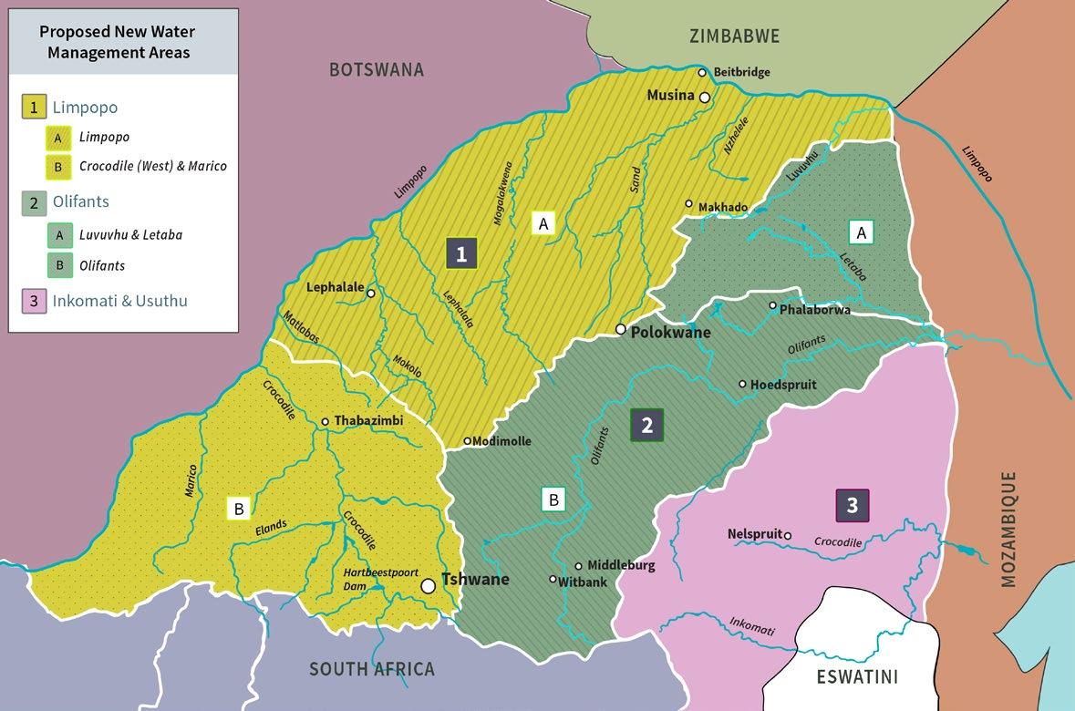
According to national office DWS officials, the Limpopo CMA as it is currently demarcated (area 1 A and B below – from the Marico (Madikwe), via the Crocodile (West) river, where the Mokolo Crocodile West Augmentation Project (MCWAP) is proposed, past the Sand River to the Nzhelele), will go through an establishment phase (starting with the board), and then be expanded to include the current Olifants CMA. In other words, the two CMAs will merge. This will bring together the Olifants, which has been through a significant process of governance development, with the Limpopo which has not. The differences are instructive.
Figure 4: This map shows the proposed new Limpopo super-CMA, incorporating both the existing Limpopo West (in yellow) and the Olifants catchment (in green). The IUCMA area is shown in pink. Map by Toni Olivier.
The NGO, Association for Water and Rural Development (AWARD), has just completed a seven year process building resilience against climate change in the Olifants catchment. In the process, AWARD has improved the capacity for understanding and acting on water resources, biodiversity and climate change challenges across more than 400 institutions and 2000 individuals. Governance capacity was built through the establishment or strengthening of 11 stakeholder networks, and resilience practices built in municipalities, among small and commercial farmers and other groups. This work has introduced new approaches to water management, not only regarding participation, but also adaptive management and an understanding that water management is based on viewing catchments as complex social ecological systems.
The super-CMA will face a range of challenges. This includes the acid mine drainage legacy created by coal mining in the Upper Olifants, in the Emalahleni (Witbank) area, and the Crocodile (West) catchment, which starts with the continental divide in Johannesburg, and 41
includes the city of Tshwane (Pretoria) as well as the Hartebeestpoort Dam, which is plagued by excessive eutrophication as well as agriculture, mining and industrial pollution along the Crocodile River. It includes irrigation boards and large ex-homeland areas, as well as extensive platinum mining. Part of the challenges – pointed out by the 2016 Reconciliation Strategy, is the state of wastewater works in several areas. Some of these challenges have led to catchment management forums, or equivalents, growing out of citizens action, for example in Tshwane and the Hennops river (Munnik et al, 2016).
6. Water politics in the Limpopo
The various actors that were drawn together in opposition to the EMSEZ, can be seen as resources for a positive, participatory water governance that can properly deal with the challenges of a water scarce catchment. After all, these actors emerged in defence of water resources, biodiversity, the tourism sector, agriculture, existing livelihoods and the spiritual connection that local people have with the land.
An earlier battle against Coal of Africa (now MC Mining) already created alliances, knowledge and methods to oppose coal mining developments. The EMSEZ is seen by many as an extension of that earlier contestation.
The Vhembe Biosphere Reserve17 is perhaps the largest institution in the area defending ecosystems that will be placed at risk by the plans for the MMSEZ. The VBR is made up of a web of conservation, biodiversity, tourism, research and educational, interests, including indigenous knowledge and rural development aspects. With its international status and intellectual reach, it has been creating a biodiversity and sustainability perspective for the region as an alternative to heavy, fossil fuel based industrialisation. It is strongly anchored in conservation areas, most of them in Soutpansberg mountain range itself, with its very rich high biodiversity, possibly the richest in South Africa. This is strengthened by alliances with the University of Venda (Univen) and other universities worldwide, in ongoing research processes.
17 The Vhembe Biosphere Reserve is part of a network of 714 UNESCO registered Biosphere Reserves across the globe and one of 9 in South Africa, of which three are in Limpopo. The VBR is the largest biosphere reserve in South Africa, with a surface area of 30 700 km, it stretches from the Shingwedzi river in the KNP to Crooks Corner in the north, bordering the Limpopo River all the way across to Mapungubwe National Park and the Mogalakwena River in the west, down to the Blouberg-Makgabeng and Soutpansberg mountain range in the south.
It has been joined in its opposition to the EMSEZ by biodiversity and conservation based organisations, including the Endangered Wildlife Trust (EWT), the Kruger National Park, World Wide Fund for Nature (WWF), Birdlife South Africa, which all responded in detail to the EIA. Many of these organisations have also expanded into community conservation, stewardship and development projects. They have developed interests and networks around indigenous knowledge. They have also developed the ability to work together.
The Herd Reserve is a small reserve on the Nzhelele river next to Limpopo River (close to Musina), which took a strong interest in the EMSEZ developments, unlike its neighbour, the bigger Maremani reserve (owned by the Danish Aave G. Jensen foundation18), which did not get publicly involved, although its land may well be affected by the proposed Musina and Sand River Dams.
The big tomato farmers ZZ2 are veterans of the struggle against Coal of Africa, now MC Mining. They are very dependent on access to water resources, including some in off-channel dams along the Limpopo. They are a leading force in the farming community, and have started with sustainable farming and outreach to small farmers in the area.
However, the absence of water governance in the area has meant – along with other factors –that water allocation and use patterns have remained the same as in the apartheid era. As figure 5 below shows, large scale irrigation still takes the lion share of water resources in the (current) Limpopo North Water Management Area. The demand projection planning diagram (which reflects a demand of 35 Mm3/year for the EMSEZ, not the current 80 Mm3/year) illustrates that the only change that is foreseen up to 2040 is a growth in water demand for mining and industry – everything else stays the same.
18 https://www.maremani.com/the-foundations/
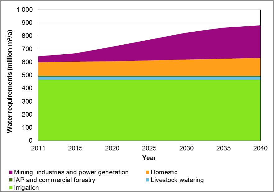
Figure 5: Graphic illustration of water demand in Limpopo North WMA, 2011 – 2040 (NLRS 2016). This DWS document reflects a demand of 35 Mm3/year for the EMSEZ, not the current 80 Mm3/year.
It could be argued that the alliance in its resistance of the EMSEZ, based on the question of water availability and water quality implications of the EMSEZ, is stepping into the empty space left by the 20 year delay in setting up CMAs. The intended roll-out of a bigger, merged Limpopo Water Management Area may provide opportunities to build a participatory, democratic water governance system in the area. There are many reasons to do so, including:
1. The long overdue transformation of the allocation and use of water resources, which currently have more in common with apartheid practices of riparian ownership than the vision of Integrated Water Resource Management in the National Water Act. In particular, the water access of vulnerable groups that form the majority of water users, but have access to minimal but crucial amounts of water, needs to be protected and extended.
2. Dealing with current water quality challenges from platinum mines and dysfunctional municipal waste water works, and preparing to deal with the pollution challenges that would accompany a coal fired power station plus a number of steel and other factories, including the northern MMSEZ development so close to an internationally shared river. 3. Rivers in the area need to be protected ecologically, for example through environmental flow regulations. It is these reserves that form the basis of life in the area. 4. Climate change is already changing conditions in the Limpopo water management area, and will continue to intensify. 5. The growth of participatory water governance in the South African section of the international Limpopo basin can also provide a powerful encouragement to similar developments in other Limpopo riparian countries and increase international cooperation, as the IUCMA has done with Mozambique.
Finally, the super Limpopo and Olifants CMA could also represent an opportunity for the DWS to reinvigorate its role as the custodian of the water resources of South Africa. Water governance supported by the state will also provide an opportunity – as we have seen in the IUCMA – to practically support the participation of voices that have so far been drowned out by stronger actors with many more resources at their disposal.
References
AWARD. 2020. Final Report. Resilim-Olifants. Resilience in the Limpopo Basin Program, report to USAID. http://award.org.za/wp/wp-content/uploads/2020/12/AWARD-RESILIM-OlifantsFINAL-REPORT-PUBLIC-Oct-2020-web.pdf
Bergh,J.S. (ed) 1999. Geskiedenis Atlas van Suid-Afrika, Die Vier Noordelike Provinsies. Van Schaik, Pretoria.
Delta-BEC, 2021. Musina-Makhado Special Economic Zone designated site Environmental Impact Assessment Report. Final report, revision 02. 1 February 2021
DWAF and WRC. 1998. A Strategic Plan for the Department of Water Affairs and Forestry, to Facilitate the Implementation of Catchment Management in South Africa. WRC Report No KV 107/98
DWAF. 2012. Gazetting of the Amendments of Water Management Areas of South Africa for Comment.
DWS 2016a. Limpopo Water Management Area North Reconciliation Strategy. Draft Reconciliation Strategy. DWS.
Flyvbjerg, B. 2014, What You Should Know about Megaprojects and Why: An Overview, Project Management Journal, vol. 45, no. 2, April-May, pp. 6-19, DOI:10.1002/pmj.21409
Flyvbjerg, B. 2013. Design by deception. The politics of megaproject approval. Harvard Design Magazine, Spring/Summer, no. 22, pp. 50-59).
Matukane, A and Pretorius, C. 2020. Integrated Water Services Report. Supporting report for the environmental impact assessment of the MMSEZ (SOC) southern development site for the establishment of a range of heavy industries, commercial- and residential sites. Compiled for the MM SEZ SOC. Matukane and Associates, August 2020.
Muller, M. 2011. Polycentric governance: water management in South Africa. Management, Procurement and Law. Volume 165 Issue MP0. Pages 1–8 http://dx.doi.org/10.1680/mpal.2012.165.0.1. Paper 1100018
Munnik, V. 2020. The reluctant roll-out of catchment management agencies: Assessing the key risks and consequences of delays in finalising institutional arrangements for decentralised water resource management. Report for the Water Research Commission of South Africa. WRC Report No. 2943/1/20, ISBN 978-0-6392-0139-9
Munnik, V, Burt J, Price L, Barnes G, Ashe, B, Motloung S. 2016. Principled, Pragmatic Revitalisation of Catchment Management Forums in South Africa. Report for the Water Research Commission of South Africa. WRC Report No. TT 682/16
DWS 2016a. Limpopo Water Management Area North Reconciliation Strategy. Draft Reconciliation Strategy. DWS.
Promethium Carbon, 2019. Specialist Climate Change Assessment Report for the proposed Musina-Makhado Special Economic Zone. August 2019.
Republic of South Africa. 1998. National Water Act No. 36 of 1998. Department of Water Affairs and Forestry, Pretoria: Government printers
Sunfrica. 2021. Final draft report for the pre-Feasibility report for the proposed Musina dam to support the Musina-Makhado special economic zone within the Musina Local Municipality, Vhembe District of the Limpopo province. March 2021.
About the Author
Dr Victor Munnik is a geographer and political ecologist. He started his career as a journalist, including for Vrye Weekblad. His PhD dealt with community struggles against pollution at the Iscor (currently Arcelor Mittal) steel factory in Vanderbijlpark. His work for the Water Research Commission focuses on civil society, catchment management and political aspects of water quality. He is a research associate at the Society Work and Politics (SWOP) Institute at the University of the Witwatersrand, at the Institute for Water Research (IWR) at Rhodes University, and at the Environmental Justice NGO groundWork.
The report was commissioned by the Fredrich-Ebert-Stiftung South Africa.
The Friedrich-Ebert-Stiftung is the oldest political foundation in Germany. Founded in 1925, it is named after Friedrich Ebert, the first democratically elected president of Germany. FES is committed to the advancement of both socio-political and economic development in the spirit of social democracy,through civic education, research, and international cooperation.
The views expressed in this publication are not necessarily those of FriedrichEbert-Stiftung.
Commercial use of all media published by the Friedrich Ebert-Stiftung (FES) is not permitted without the written consent of the FES.
Postal Address: P.O. Box 412664 Craighall 2024 Johannesburg South Africa Physical Address: 34 Bompas Road. Dunkeld West Fax: +27 11 341 0271 Tel: +27 11 341 0270 Email: info@fessouthafrica.org Web: www.fes-southafrica.org