
6 minute read
HISTORY of the Interurban Trail to Mount Vernon — and a NEW BEGINNING!


By Tom Peffer, Trails Development Committee Chair
From 1912 to 1916, the Cedar Rapids and Iowa City Railway and Light Company (now Alliant Energy and Travero) set out to acquire a continuous 100-foot-wide strip of land between Cedar Rapids and Lisbon, a distance of some 13 miles.
Advertisement
Over that five-year period, a few civic-minded men and women in Cedar Rapids oversaw the construction of a trolley rail line and a power line running the entire length. The right-of-way was cleared, the rail bed was graded and stabilized, bridges were built, ties and rail were laid, power poles and power lines were erected, and a trolley line was put in operation.
The trolley line and power line ran through the communities of Cedar Rapids, Broad Acres, Urbandale, Gardendale, Bertram, Cornellton, Mount Vernon and into Lisbon.
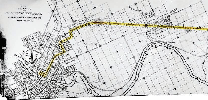
Original Mount Vernon Interurban strip map
The company’s original objective was to extend the rail line until it reached the Mississippi River. However, the newly constructed Lincoln Highway followed a similar path. As automobile use increased, the passenger line fell out of favor with the public and it eventually stopped operating.
The trolley line was formally abandoned by Order of the Iowa District Court dated March 30, 1928. The Decree stated at page 6, “…the operation of the street railroad and interurban railroad has been at great loss, and the earnings of said line have been less than the operating expense connected therewith, and that plaintiffs could not continue to operate said line without great and increasing and continuous loss.” After the operation of the trolley line was abandoned, the rails and ties were removed and the communities of Broad Acres, Urbandale, Gardendale and Cornellton faded into history.
Although the operation of the trolley line was abandoned, the entire 100-foot-wide right-of-way has continued to be used and maintained by Alliant Energy as a utility corridor for the power lines which had been erected in the right-of-way.
Alliant Energy has since abandoned the portion of the right-of way that went from Mount Vernon to Lisbon.
In 1992, Linn County approached Alliant Energy about purchasing approximately 7 miles of the utility corridor, to develop it, “…into a public, multiple use, conservation/recreation corridor”, from the then existing eastern boundary of Cedar Rapids (Berry Road) to the western boundary of Mount Vernon.
To assist in its effort to purchase that portion of the utility corridor, the Linn County Conservation Board commissioned a detailed Feasibility Study for a “Proposed Interurban Greenway Trail, Cedar Rapids to Mount Vernon”. After further discussions, Alliant Energy declined to sell an interest in the utility corridor for a conservation/recreational trail.
In December 2000, Alliant Energy sold its interest in the portion of the utility corridor from Indian Road SE to 34th St. SE to the City of Cedar Rapids. This segment runs through Bever Park.
In 2017, Alliant Energy reevaluated its position and approached Linn County about purchasing Alliant’s interest in the entire 100-foot-wide utility corridor from 34th St SE in Cedar Rapids to Mount Vernon, reserving an easement to continue to maintain its power lines. The negotiations resulted in a February 13, 2019 Memorandum of Understanding Regarding Survey Expenses and Purchase/Sale of Interurban Trail.
After the agreement with Linn County was finalized, Alliant Energy sent a letter to all landowners adjacent to the utility corridor regarding a survey that needed to be done and the impending sale to Linn County. The company received mostly positive feedback from adjacent landowners, with some suggesting that a nearby recreational trail increased the value of their property.
The “not in my back yard” phenomenon of the past is much less prevalent these days, as more and more people continue to learn about and experience the various benefits of nearby trail connections.
With the completion of the survey and the recording of Plats of Survey from 34th St. SE to Mount Vernon, and after further negotiations, an agreement was reached whereby the City of Cedar Rapids would purchase Alliant Energy’s interest in the utility corridor, subject to a utility maintenance easement, from 34th St. SE to Rosedale Road. Linn County would purchase Alliant Energy’s interest in the utility corridor, subject to a utility maintenance easement, from Rosedale Road to the western edge of Mount Vernon. On January 13, 2021, a Quit Claim Deed from Alliant Energy to Linn County was recorded. On March 29, 2021, a Quit Claim Deed from Alliant Energy to the City of Cedar Rapids was recorded. The recording of those documents at last allows Linn County and Cedar Rapids, respectively, to begin the preparation necessary to make the Interurban Trail between Cedar Rapids and Mount Vernon a reality. The process of “Making Trails Happen” can now begin in earnest.
The City of Cedar Rapids contemplates the completion of a recreational trail from Indian Road SE, through Bever Park, to East Post Road within the next 4-5 years. The balance of the City portion of the trail, from East Post Road to Rosedale Road will be completed later, and will compete for trail dollars with additional work on the Edgewood Trail, the Cherokee Trail, the Lindale Trail, the CEMAR Trail and the 4th Street Trail (Cedar Valley Nature Trail).
Linn County, currently expanding the hard surfacing of the Cedar Valley Nature Trail to Urbana, filling gaps and hard surfacing the Grant Wood Trail east of Cedar Rapids, and working on expansion of The Highway 100 Trail, intends to initiate the work on the Interurban Trail as quickly as funds become available.
Completion of the Interurban Trail will provide the area with a much-needed east/west recreational trail, some 13 miles in length. The trail will connect Coe College with Cornell College. It will intersect with the Sac and Fox Trail. It will intersect with the Dows Maniti Trail, which in turn will connect with the Grant Wood Trail. By extending the Interurban Trail to the north out of Bever Park, the Interurban Trail will connect with the CEMAR Trail, which connects Cedar Rapids and Marion.
The Interurban Trail will eventually connect Cedar Rapids, Bertram and Mt. Vernon, not with a trolley line, but with a safe, beautiful, graded walking, jogging and biking recreational trail. Once completed, it will fulfill the vision of those men and women who, even prior to WWI, realized the importance of connecting Cedar Rapids with Mt. Vernon. ■


