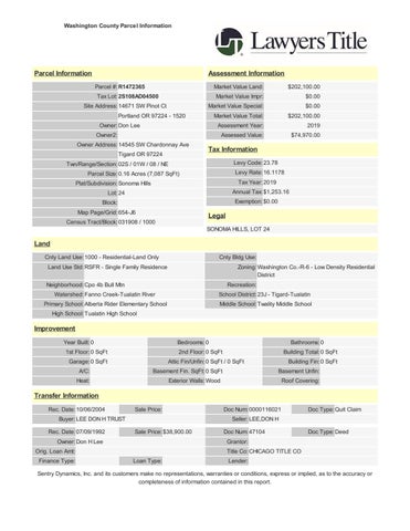
Washington County Parcel Information
Parcel Information
Assessment Information
Parcel #: R1472365 Tax Lot: 2S108AD04500 Site Address: 14671 SW Pinot Ct Portland OR 97224 - 1520 Owner: Don Lee Owner2: Owner Address: 14545 SW Chardonnay Ave Tigard OR 97224 Twn/Range/Section: 02S / 01W / 08 / NE Parcel Size: 0.16 Acres (7,087 SqFt) Plat/Subdivision: Sonoma Hills Lot: 24 Block: Map Page/Grid: 654-J6
Market Value Land: Market Value Impr: Market Value Special: Market Value Total: Assessment Year: Assessed Value:
$202,100.00 $0.00 $0.00 $202,100.00 2019 $74,970.00
Tax Information Levy Code: 23.78 Levy Rate: 16.1178 Tax Year: 2019 Annual Tax: $1,253.16 Exemption: $0.00
Legal
Census Tract/Block: 031908 / 1000 SONOMA HILLS, LOT 24
Land Cnty Land Use: 1000 - Residential-Land Only Land Use Std: RSFR - Single Family Residence Neighborhood: Cpo 4b Bull Mtn Watershed: Fanno Creek-Tualatin River Primary School: Alberta Rider Elementary School
Cnty Bldg Use: Zoning: Washington Co.-R-6 - Low Density Residential District Recreation: School District: 23J - Tigard-Tualatin Middle School: Twality Middle School
High School: Tualatin High School
Improvement Year Built: 0 1st Floor: 0 SqFt Garage: 0 SqFt A/C: Heat:
Bedrooms: 0 2nd Floor: 0 SqFt Attic Fin/Unfin: 0 SqFt / 0 SqFt Basement Fin. SqFt: 0 SqFt Exterior Walls: Wood
Bathrooms: 0 Building Total: 0 SqFt Building Fin: 0 SqFt Basement Unfin: Roof Covering:
Transfer Information Rec. Date: 10/06/2004 Buyer: LEE DON H TRUST Rec. Date: 07/09/1992 Owner: Don H Lee Orig. Loan Amt: Finance Type:
Sale Price:
Doc Num: 0000116021 Seller: LEE,DON H
Doc Type: Quit Claim
Sale Price: $38,900.00
Doc Num: 47104 Grantor: Title Co: CHICAGO TITLE CO Lender:
Doc Type: Deed
Loan Type:
Sentry Dynamics, Inc. and its customers make no representations, warranties or conditions, express or implied, as to the accuracy or completeness of information contained in this report.
01ÿ3456ÿ678579 7 ÿ 146
4 ÿ 9ÿ 4 ÿ 9 7 ÿ 7 97ÿ ÿ 767
ÿ
ÿ
4 ÿ 9 4 ÿ 45 3ÿ ÿ 0!ÿ ÿ"7 46 9 ÿ 74!7 6 ÿ# 9 6 ÿ$ 76 3ÿ%!&'()#'*+''ÿ, ÿÿ./0/123ÿ40561728960 ÿÿIC/132<ÿ40561728960ÿJ=KLMNOLPQLLÿÿÿÿ
76
7ÿ 9 R56 9
4 S6 ÿS 46 46 7 ÿ 9 4 ÿ 4 ÿ 763 \]^ÿ_ ÿ 4ÿ4 7 ÿ # `ÿaÿb ÿS97ÿ# 9 6 ÿ!5 63 T ÿ#79
4 ÿÿÿUVWXYXZ[ 4 9 ÿ ÿ ÿ ÿ ÿ ÿ ÿ ÿ 7 7 6 ÿ !7
9 ÿ 1 46 ÿ
7 ÿ b ÿ S9 7 4 76ÿ 9ÿ 9 # 9 6 ÿ_c 3ÿ 1176ÿ 7 7 ÿ5 4 ÿÿÿÿÿÿÿd64 ÿ&+ÿ@ÿ! 7 ÿ+ÿ@ÿ"7 6 ÿ&+ÿ@ÿ! 677 ÿ! 7 ÿ&' 167857 3ÿ 9 7 ÿ8579
4 9 4
4 `
ÿS6 ÿ 64e ÿf45 63 g79 ÿÿ:16;/18<ÿ=/21>?
ÿc7 64h9ÿS6 ÿ!76 7ÿ)67 64 76 3ÿ@ÿ A 4
_iS 7 ÿR5 3ÿj&9 ÿ7 ÿ 7 6ÿ37 6` g79
Aÿ 9 0 ÿS6 ÿ"4 ÿc 7 7ÿ# 9 6
_iS 7 ÿR5 3ÿj&9 ÿ7 ÿ 7 6ÿ37 6` g79 ÿÿ=B1C/<ÿ=/21>? 0 ÿk!T#ÿ_iS 7 ÿR5 3ÿj&9 ÿ7 g79 ÿÿD20Eÿ=/1C9>/F 7 6ÿ37 6` 645 ÿ 76ÿ"7945 7ÿ)67 $$Tk"ÿcl afSbbÿcl ÿÿGB93E90Hÿ=/1C9>/F !76 7ÿ# 9 6 ÿ146ÿb
ÿ)99799 7 !$ $c)ÿn0bb@ "k!l"0# k )67 @m4 7 !
4 ÿ# 9 6 ÿ_iS 7 ÿR5 3ÿj&9 ! 7 ÿ 7 6ÿ37 6` d 67ÿ# 9 6 ÿ_iS 7 ÿR5 3ÿj&9 ÿ7 lod" 7 6ÿ37 6` d 67ÿc 7 7 ÿp4 7 q&(q T 6 ÿ# 9 6 4 ÿ0 ÿT 6 ÿ# 9 6
46 ÿf7 3ÿT ÿ)67 4 ÿ ÿ 46 ÿf7 3ÿ!5 ÿ)67 ! 44 ÿ# 9 6 ÿ_iS 7 ÿR5 3ÿj&9 ÿ7 r4.N\O]rsNDNr4t 7 6ÿ37 6` k 7
4 ÿT67 juv jaÿ"43ÿ"4 769 4 99 4 76ÿ# 9 6 )9979946ÿ)67 u T$*f
m7 ÿT 6
4 ÿ$6 4 5
3ÿT ÿc f5 ÿc45 ÿ 4 7 ÿe
ÿ ÿn 9 46 ÿ ÿ 5 56 ÿ"79456 7 n 9 46 ÿwÿ 5 56 ÿ"79456 7ÿ0 7 463 4
0 7 463ÿ)67 ) 6 46 ÿ$ 76 3 4 ÿ 4 7 ÿe
ÿ ÿ) 6 46 ÿ$ 76 3 T$#ÿ# 7ÿp4 7 T$# ja*@&u@q& $#$lÿ# 9 6 %f !$ $c)ÿn0bb! T 7 959ÿl6 'j&u'( 7 959ÿf 4 &''' 7 959ÿf 4 645 ÿ & 7 959ÿ 74 *&'qv'j&u'(&''' p 4 7 uv%%* 6 7ÿn 5 76 T6 7ÿ# 9 49 ÿ_+'j`ÿq%+aq&vv 6 7ÿ#64 4A T6 7ÿ# 9 49 ÿ_+'j`ÿq%+aq&vv l 4 9ÿf64 769ÿ 5 7 T 7 ÿq+*ÿaÿ 6 ÿRq xÿr?/ÿE282ÿ32</1FÿBF/Eÿ86ÿE/19C/ÿ98/7Fÿ90ÿ8?/ÿ1/;618ÿ21/ÿ2FF/7y3/Eÿ5167ÿ7B389;3/
ÿ
This map/plat is being furnished as an aid in locating the herein described Land in relation to adjoining streets, natural boundaries and other land, and is not a survey of the land depicted. Except to the extent a policy of title insurance is expressly modified by endorsement, if any, the Company does not insure dimensions, distances, location of easements, acreage or other matters shown thereon.
This map/plat is being furnished as an aid in locating the herein described Land in relation to adjoining streets, natural boundaries and other land, and is not a survey of the land depicted. Except to the extent a policy of title insurance is expressly modified by endorsement, if any, the Company does not insure dimensions, distances, location of easements, acreage or other matters shown thereon.
Property
Property Address
2020 Real Market Value
$210,180
R1472365 14671 SW PINOT CT, UNINCORPORATED, OR 97224 2020 GENERAL INFORMATION
RELATED PROPERTIES
Property Status
A Active
Property Type
Residential
Legal Description
SONOMA HILLS, LOT 24
Alternate Account Number
-
Neighborhood
SWBM SOUTHWEST BULL MTN.
Map Number
2S108AD04500
Property Use
1000: RESIDENTIAL-LAND ONLY
Levy Code Area
Linked Properties
-
Property Group ID
-
Grouped Properties
-
Split / Merge Date
-
Split / Merge Accounts
-
Split / Merge Message
-
023.78
2020 LAND SEGMENTS STATE CODE
SEGMENT TYPE
LAND SIZE
L1
10: S F VHS
0.00 acres
CERTIFIED / IN PROCESS VALUES YEAR
IMPROVEMENTS
LAND
RMV
SPECIAL USE
ASSESSED VALUE
2020
$0
$210,180
$210,180
$0
$77,210
2019
$0
$202,100
$202,100
$0
$74,970
SALES HISTORY SALE DATE
SELLER
BUYER
INST #
SALE PRICE
INST TYPE
Unknown
Unknown
2004116021
-
DW
7/7/1992
Unknown
Unknown
1992047104
$38,900
DW
4/11/1990
Unknown
Unknown
1990018818
$32,450
DW
Unknown
Unknown
PLAT6424
-
UNK
If applicable, the described property is receiving special valuation based upon its use. Additional rollback taxes which may become due based on the provisions of the special valuation are not indicated in this listing.
TAX SUMMARY TAXYEAR
? Details
Eàective Date:
TOTAL
AD
SPECIAL
BILLED
VALOREM
ASMT
PRINCIPAL
INTEREST
DATE
TOTAL
PAID
OWED
2020
$1,283.84
$1,242.56
$41.28
$1,283.84
$0.00
-
$0.00
2019
$1,253.16
$1,208.35
$44.81
$1,253.16
$0.00
-
$0.00
2018
$1,201.70
$1,157.46
$44.24
$1,201.70
$0.00
-
$0.00
2017
$1,157.73
$1,114.41
$43.32
$1,157.73
$0.00
-
$0.00
2016
$1,102.88
$1,060.87
$42.01
$1,102.88
$0.00
-
$0.00
2015
$1,077.12
$1,016.68
$60.44
$1,077.12
$0.00
-
$0.00
2014
$1,064.61
$986.57
$78.04
$1,064.61
$0.00
-
$0.00
2013
$1,019.68
$964.55
$55.13
$1,019.68
$0.00
-
$0.00
2012
$982.14
$0.00
$0
$982.14
$0.00
-
$0.00
2011
$957.99
$0.00
$0
$957.99
$0.00
-
$0.00
2010
$930.22
$0.00
$0
$930.22
$0.00
-
$0.00
TOTAL TAXES DUE Current Year Due
$0.00
Past Years Due
$0.00
Total Due
$0.00
*Total Due shown may not reÖect current amount due
2009
$919.32
$0.00
$0
$919.32
$0.00
-
$0.00
2008
$885.19
$0.00
$0
$885.19
$0.00
-
$0.00
2007
$852.76
$0.00
$0
$852.76
$0.00
-
$0.00
TAXYEAR
RECEIPT NUMBER
TRANSACTION DATE
PAYMENT AMOUNT
2020
WASH-2020-53216
11-9-2020
$1,245.32
2019
5993384
11-4-2019
$1,215.57
2018
5802886
11-6-2018
$1,165.65
2017
5739972
2-20-2018
$1,183.46
2017
5739981
2-20-2018
$1,183.46
2016
5374658
11-8-2016
$1,069.79
2015
5186454
11-10-2015
$1,044.81
2014
4970215
11-10-2014
$1,032.67
2013
4852432
11-20-2013
$989.09
2012
4474864
10-22-2012
$952.68
2011
4260506
10-26-2011
$929.25
2010
4043964
10-27-2010
$902.31
2009
3835483
11-2-2009
$891.74
2008
3606009
10-29-2008
$858.63
2007
3391024
10-30-2007
$827.18