LAST FRONTIER THE LIFE & BEAUTY OF ALASKA
MAGAZINE | MAY - JUNE 2019
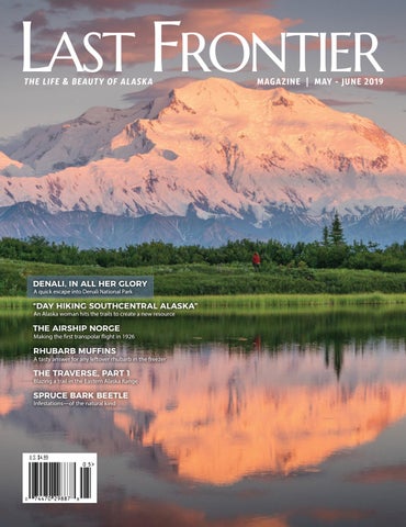
DENALI, IN ALL HER GLORY A quick escape into Denali National Park
“DAY HIKING SOUTHCENTRAL ALASKA” An Alaska woman hits the trails to create a new resource
THE AIRSHIP NORGE
Making the first transpolar flight in 1926
RHUBARB MUFFINS
A tasty answer for any leftover rhubarb in the freezer
THE TRAVERSE, PART 1
Blazing a trail in the Eastern Alaska Range
SPRUCE BARK BEETLE Infestations—of the natural kind
U.S. $4.99
M AY - J U N E
2 0 1 9 1
100 Days in Denali
DENALI, IN ALL HER GLORY A QUICK ESCAPE INTO DENALI NATIONAL PARK
STORY BY CECIL SANDERS PHOTOGRAPHY BY CECIL SANDERS, CHRISTIAN HOLLUMS & CHRIS DAVILA
14
L A S T F R O N T I E R M AG A Z I N E www.lastfrontiermagazine.com
F
or more than 20 years Denali has loomed over me and I’ve felt a sense of pride from living near North America’s tallest peak. However, Denali always seemed
like an attraction for non-residents, so I’d done little more than admire it from a distance while driving to and from other places. On clear winter days in the vicinity of my hometown of Wasilla, Denali adorns the horizon. Occasionally, a summer drive to Talkeetna on the Parks Highway yields a closer view, though it is still quite a distance away. Seeing the grandeur of the mountain from afar has felt insufficient, and I’ve longed to experience a closer look. My opportunity came in 2018 when Christian Hollums, founder of Wayfare Collective (a locally based North American adventure photography collective), offered me the chance for a quick escape to Wonder Lake in Denali National Park and Preserve. I eagerly accepted. The tour van arrived early one morning in Wasilla. After I loaded my camping and photo gear into the back, our driver opened the passenger side door and I was met by a sleepy cabin of Wayfare members. I greeted those who woke up from my intrusion with a quiet hello. Several passengers were still trying to come awake, while another was stretched out fast asleep. We had a long day of driving ahead and I didn’t blame them for wanting to rest before reaching our destination. Pulling out of the Carrs/Safeway parking lot, we headed north on the Parks Highway. After a while members of the group stirred a bit, and conversations commenced. Air Force acquisitions officer, Chris, originally from Texas, and I found we both enjoyed our Sony A7 cameras. Melody from Anchorage, KG, and son Cayden from Eagle River, conversed about their past
Wayfare member Chris Davila looking out across the lush Denali National Park landscape. Photo by Christian Hollums
Looking down upon the braided Toklat River, near Polychrome Pass. Photo by Cecil Sanders
group photo adventures with Wayfare. Two more, Leslie and Genevieve, were fast asleep in a mash of jackets and photo gear in the front row next to Christian. I soon felt the sense of a close camaraderie amongst the members. One thing we all had in common was our silent wishes and audible requests for the weather to cooperate so that we could catch a glimpse of Denali. Rain was in the forecast.
When we arrived at Stoney Hill Overlook, our group was thrilled to see clouds were starting to break away from the peak of Denali. Photo by Cecil Sanders M AY - J U N E
2 0 1 9 15
Denali, In All Her Glory
16
L A S T F R O N T I E R M AG A Z I N E www.lastfrontiermagazine.com
Denali, In All Her Glory After a long and sleepy ride, our driver exited the Parks Highway
here as mere spectators, but to capture the show. We gathered our
onto Denali Park Road—we were halfway to our destination,
gear and raced to find an angle, a leading line, or a subject to frame
Wonder Lake Campground. Only about 85 miles separated us from
within this surreal scene.
the campsite, but the travel would be much slower, and we hoped photo opportunities would be the only cause for delays.
Our group was on a mission to photograph Denali. Everyone went their separate ways, searching for unique angles. Little did we
Clouds partially covered the Alaska Range. The midday sun burned
know, this was only the beginning of a long incredible afternoon
the thinning cloud cover encompassing the mountain and much of
and evening for photography.
the range. Our group would let out hopeful and energetic appeals to the mountain and the weather every time a new ridgeline or
Upon our return to the parking lot, a lady with a pleasant but tired
partial view of the peak would make a brief appearance.
voice talked with several of us. She, a tourist named Leesa, had long wanted to see this sight. She conveyed her sense of satisfaction, but
We descended into a deep valley and Denali’s summit disappeared
then began to tell us her troubled story. As we were on a mission
behind a ridgeline; it was anybody’s guess as to what we would see
for amazing photos, she also was on a mission to save her life. She
at the next viewpoint. Our van motored back up from the valley,
needed a kidney replacement, and her time was running short. In
and at about 1:45 p.m. we exited the dusty road to a small parking lot—the Stony Hill Scenic Overlook. Elation and joy spread quickly throughout our group. Denali, in all her glory, was on display like an actor on a stage, and we were the audience. We stood amazed at the performance before us, but suddenly remembered we weren’t
A sow and two cubs bask in the warm summer heat as clouds move away from the peak of Denali. Photo by Cecil Sanders
Our group meandered around Reflection Pond at 10:30 p.m. waiting and hoping to see vibrant evening tones on the Alaska Range. Photo by Cecil Sanders
Park Road connects Reflection Pond to the Wonder Lake Campground. Photo by Cecil Sanders M A R C H - A P R I L
20 1 9 17
Alpenglow on the Alaska Range reflecting on Reflection Pond in Denali National Park. Photo by Cecil Sanders
18
L A S T F R O N T I E R M AG A Z I N E www.lastfrontiermagazine.com
M AY - J U N E
2 0 1 9 19
Denali, In All Her Glory this moment all our wonderment of Denali took a pause … life:
sleeping bags, and food down a small park road to the Wonder
our trouble, our joy, our desires are given a new perspective when
Lake Campground. The clouds around the Alaska Range had almost
learning of the challenges others are facing. Leesa’s journey was
entirely dissipated and the scenery was stunning. So much for the
resting upon hope—hope that she could find a match that would
forecast of rain. Upon arrival at the campground, we set about
allow her to continue life’s journey.*
erecting our tents, and then scouting Wonder Lake, as well as a trail above the ridgeline east of the lake. Before venturing too far
We parted ways with Leesa at Stony Hill, and continued down our
we prepared needed sustenance so we’d be ready for our evening
bumpy course to Wonder Lake. Suddenly, a new set of characters
adventure—finding the perfect shot of Denali at sunset. In late July
entered the stage. As if the view of Denali wasn’t spectacular
the glow of the sunset is still on the mountains at 11:30 p.m.
enough, we were now offered a grizzly sow and two playful cubs in the warm mossy tundra at a low spot next to a marshy creek. We
A light breeze kept the mosquitoes slightly at bay, but it also meant
excitedly climbed back out of the van, and staying within arm’s reach
Wonder Lake would have surface ripples. The group’s goal was to
of safety, once again began capturing this wild and dangerous, yet
find a body of water large enough and properly situated in elevation
somehow serene, setting on display about 150 yards off the road.
to capture the desired composition of Denali with alpenglow and a
Mama and her cubs plodded gracefully across the hummocks. She
glassy reflection. All signs pointed to Reflection Pond as having the
kept an eye on us and her cubs, and occasionally peered off into the
most potential in our vicinity.
distance to a line of figures walking down a ridgeline. She closely watched the unsuspecting hikers until they finally caught sight
Warm sunset hues began to cover the Alaska Range. We gathered
of her. This was a reminder that in the backcountry one must be
our gear and hiked uphill to the Denali Park Road, and west to the
observant and take every precaution to preserve life and limb, as
pond. Excitement reached a fever pitch as the mountain, adorned
this sow was ready to do so as well.
with tinted clouds and a soft glow, stood silent, ready and waiting to be our glorious subject. The dusty single-lane road finally led
Later, in the early evening, we arrived at a wide spot in the road
us to an overlook of Reflection Pond, elevated above and to the
where our driver let us out. We hiked our photo gear, tents,
side of Wonder Lake. We hooped, we hollered, we exchanged
20
L A S T F R O N T I E R M AG A Z I N E www.lastfrontiermagazine.com
Denali, In All Her Glory
Wayfare member KG explores a glassy pond at Mile 78 early the next morning. Photo by Christian Hollums
animated comments laden with colorful descriptors at the sight we now beheld. Our long journey was rewarded by a view that so many visitors, residents and tourists alike, long to see. Denali reflected with alpenglow across the pond for what felt like an eternity as we squeezed our shutter buttons, resituated our angles, and continued capturing the illuminated mountain. We were immensely grateful for this glorious sight. Yet, a part of me didn’t feel worthy. Tourists spend thousands upon thousands of dollars to get this view, many times completely missing it because of cloud cover. We locals have endless opportunity to stroll into the park all year long to take in this breathtaking sight. Unfair? No. Incredibly blessed? Definitely! My gratitude is said best through the lyrics of a Tracy Byrd country music song: “I tip my hat to the keeper of the stars.” The next morning we packed up early and hauled our gear to the road where our driver was to meet us for the journey back home. Our window for sleep was narrow, and most of us had an ache here or there, but no one was complaining. We were each gratified with what we were bringing back from our short 20 hours in the park. We were bringing back memories of an evening that could only be described with the overused adjective, ‘epic,’ and photos that would rise to the top of our personal portfolios. Yes, epic is the definite descriptor of
Wayfare member Cayden capturing the scene. Photo by Chris Davila
EXCLUSIVE CONTENT To see many more photos by the different members of the Wayfare Collective on this trip, check out our digital magazine at LastFrontierMagazine.com.
our experience with Denali—in all her glory. A *Since this article was written, we’ve followed Leesa’s story. She received a kidney transplant and is regaining her strength daily. We hope to see her again on her next Alaskan adventure. Thank you to Wayfare Collective member Melody Anne for her inspiration for writing this article, as well as Aurora Expeditions for the
CECIL SANDERS is the owner and publisher of Last Frontier Magazine. He enjoys getting away from the computer and experiencing Alaska’s incredible beauty when the opportunity presents itself.
transportation to Denali and back. M AY - J U N E
2 0 1 9 21
Photo by Grant Wilson
THE TRAVERSE
PART I: BLAZING A TRAIL IN THE EASTERN ALASKA RANGE STORY: MICHAEL HOPPER
Lodge at Black Rapids with a growing band of cohorts. For three years running from 2009 to 2011, I’d watched the Alaska Wilderness Classic racers head out in packrafts to cross the daunting Delta River on their separate ways along the Range’s north flanks. From my breakfast counter bar stool I always secretly thought, How hard could it be if they can race it?
PHOTOGRAPHY: STEVEN MILEY, GRANT WILSON & PHILIP WILSON
“Adventure is a dish that is best eaten takeout, in the comfort of one’s own home…” - Michael Cabon
T
he “slip”—like all dumb-ass moments in my life—is perversely burned into my memory. One step too far in a rapidly rising creek—two poorly placed trekking poles— and I was face down in a roiling water slide. Desperate only to shed the waterlogged burden of my backpack—the trekking poles were blessedly history—I never noticed the missionary ride over a huge midstream boulder that I took before I managed to flip onto my back and pull my arms free. I was able to snag one shoulder strap and so crawled the last few feet of the crossing underwater, still equipped for the remainder of The Traverse.
The Traverse of the Eastern Alaska Range (EAR) earned italics as a grand dream only after too many dark winter-night beers at the
24
The Eastern Alaska Range is a distant mirage for most Interior Alaskans and only a rumor in Anchorage. A small percentage of Fairbanksans can name Deborah, Hess, and Hayes as the dominant features titillating their southern horizon but few know which is which. I have made six unsuccessful attempts to climb the true queen of that triumvirate, 13,800 foot Mt. Hayes. I knew of her beauty and her beast, but I had always flown in. The one out-of-print guide book to the area assured me that it was a simple three-day ski in to her base from the highway and an equally simple three-day climb. But years of climbing—and skiing—in our local mountain drainages had taught me otherwise: nothing is simple in the EAR and nothing in the alpine distance is a predictable “three-day” jaunt. So I, like the vast majority of Interior Alaskans, knew next-to-nothing about the land between the Richardson Highway and Mt. Hayes and fully nothing about the unseen miles of terrain from her to her sisters, Hess and Deborah.
L A S T F R O N T I E R M AG A Z I N E www.lastfrontiermagazine.com
And there the trails ended … and this story began. After an overflight to determine a potential route, we divided The Traverse into three 30-air-mile portions. The actual hiking mileage There is none of John Muir’s “gentle wilderness” in Alaska. In over novel, uneven, demanding terrain was difficult to estimate. fact, what I found on my summer forays into the Alaska Range I conservatively guessed 30 air miles might be more like 50 on was arduous bushwacking on dubious map headings that the ground. Unlike the Wilderness Classic racers (the winners usually ended with soaked feet and blunted spirits. Buried in my completed it in a little over four days), we estimated taking 15 misery and alder-hell, I got only brief glimpses days of hiking which would amount to 10 miles of the mountains that called to me from distant each day. We planned to eat and sleep comfortably But there hasn’t been Fairbanks. Eventually backcountry skiing became throughout our journey and so arranged for two my key to entering the vastness of our local strategically placed food/fuel depots to lighten our a single summer day mountain kingdom. Winter’s cold and snow limited loads and brighten our spirits. at the Lodge where my explorations to the access provided by the frozen drainages and glaciers of Isabel Pass. Once But my interest wasn’t to simply repeat with a the foothills just construction of the Lodge at Black Rapids began in modicum of comfort what hardier racers had across the Delta River 2002, I was content to spend my summers building pioneered. I had come to Alaska in 1984 with an and maintaining the Lodge and day-hiking. adventurous itch I first scratched in high school haven’t called to me. with my older brother in the alpine meadows But there hasn’t been a single summer day at the and mountains of Yosemite Park. Each summer Lodge where the foothills just across the Delta River haven’t throughout college we’d rendezvous to follow new trails into called to me. Mts. McGinnis and Moffit, just visible from the lodge the Sierra Nevadas as we slowly found our separate ways to in amongst foothill gaps, sing snow-covered backup, the siren adulthood. Ultimately my way took me to distant Interior Alaska song of an extreme alpine Shangri La. And with equal regularity, and I immediately sought out area trails. Repeated hikes to the European visitors would innocently ask upon arrival, “Where are heights on the Granite Tors and Eagle Summit Trails served only to your trails?” I would sheepishly point to the rough cross-country point me in the direction of the distant Alaska Range.
Trail map—hiking from east to west, the group set out from The Lodge at Black Rapids.
M AY - J U N E
2 0 1 9 25
The Traverse ski trails I had hacked out on the tame slopes that rose behind the lodge… The summer of 2018 I vowed would be different. So with the patient compliance of my wife and the knowing sighs of my grown kids, I decided to lay out the makings of a trail that started across the river and went west until it met macadam. I not only wanted to walk in the footsteps of the Wilderness racers, I wanted to document the journey and assess its trail potential and building challenges. Ultimately I wanted to see Alaska host a second John Muir Trail, one on a scale even he might have trouble imagining. To that end I enlisted a former long-time trail-building crew boss of the National Park Service, Tim Beale, professional wilderness photographer, Steven Miley, and an undergraduate geology student from the University of Alaska Fairbanks (UAF) and his younger brother, both experienced drone operators, Philip and Grant Wilson. Together we set August 1st for tip-off. But talk about ‘build it and they will come’—Peter Winsor, UAF professor of oceanography and long-distance trail runner and accomplished climber, and Steven Decker, senior civilian instructor at the elite Northern Warfare Training Center at Black Rapids, soon added their names to the roster. Retired special-ed teacher and world adventurer extraordinaire, John Hildebrand, returning just in time from a solo 30-day mountain bike circumnavigation of Iceland, rounded out our entourage. Someone besides me had to be eligible for Medicare. Sunny August 1st found us right on schedule, dragging a 14-foot rented raft nearly a mile to a calm river bend put-in on an alarmingly high Delta River. We’d had weeks of sunshine and warm weather but Alaskan rivers are weird: hot, dry weather melts glaciers and raises rivers. Seven guys with full packs crammed in paddle-ready and shoved off; Steven had preceded us in a packraft to film our arrival on the far side of the Delta River. Every single paddle was needed to safely moor our mildly-panicked boatload into our planned pull-out.
Group paddling across the Delta River. Photo by Steven Miley
Decker on top of the outflow cave. Photo by Philip Wilson
We gratefully tied our deflated craft to a half-buried logjam— Steven stashed his personal packraft judiciously apart—and we set out on our grand adventure. An owl calmly watched our creekbed approach in the last broad daylight we were to see for the next seven days; five miles up-creek it was to start raining, the small glacier creek was to swell, and we would not cross any mountain defile without trepidation for the next seven days. Our photographic ambitions were to prove as dampened as the low-hanging clouds that soon smothered our pleasantly Google-mapped route. From the air the small un-named glacier with which we were confronted on our first day seemed as unremarkable as the 26
Group hiking up a steep slope into the fog. Photo by Grant Wilson
L A S T F R O N T I E R M AG A Z I N E www.lastfrontiermagazine.com
The Traverse “gently” sloping meadowed approach to the first inter-glacier pass we were subsequently to ascend. Philip had skied up-glacier in an impressive ascent of a nearby peak the previous winter and buoyed our over-flight confidence. But at their terminus, even anonymous glaciers become giant fire-hoses as ice compressed over the centuries suddenly melts and seeks flow and release. No way were we crossing that moving water. Somehow we had to go up and over that cavernous outlet.
rain-swept tundra ramp to our first campsite I was to experience my first real intimation of aging.
It was a moment into which Army Rangers are taught to step. And the only former Ranger amongst us—everyone called him “Decker”—stepped in, calmly climbing up, over, and around the gaping hole from which a foaming grey geyser shot.
Three and a half years earlier I had survived being buried in an avalanche. I managed to dig myself out but not in time to save my buddy, Erik Peterson, or my best dog, Rowdy [see Last Frontier, June 2015 issue]. Two months later I was rushed into emergency lung surgery during which the surgeon discovered I’d inhaled glacier grit along with snow during my ordeal and had an abscessed, infected left lung. In the interim I’d nearly coughed myself to death, developed pleurisy in that lung, and laid in bed losing weight. Out of the hospital, I was determined not to give in to a crippling fear of avalanches. I was backcountry skiing by spring hoping to leave the tragedy behind.
Seven of us sheepishly followed only to be confronted with the nightmarish navigation of razor-sharp, loose, wet glacial moraine in dense cloud cover. GPS mapping apps kept telling us where we were on our phone-size map but the terrain was so tortured, no “route” seemed obvious. Eventually, after skirting ice cliffs that fell away to frightening foggy depths, we found our way down to a glacial drainage we hoped might prove to be a side boundary and a way off and out, only to be confronted by a steep, scree-filled slope blocking our way on the other side. Decker again proved his worth scrambling straight up the bluff, leaving the rest of us to somehow navigate our way up while avoiding the falling rocks of those ahead. Our first rest break was amongst the seemingly impenetrable brush atop the bluff; the way out and up was only clear to Decker. He’d somehow taken a compass heading to the hidden pass above from what little we could glean of our place on the map and so, he confidently pointed us all in a general direction up. Switchbacking game trails soon merged and led us out of the brush and steeply up a clear trail to the spine of a distinctive hogback ridge I recognized from my overflight.
It wasn’t like I was dying. I knew that much from experience. I’d become something of a standing joke amongst family and friends for the many brushes with death I’d managed to survive. But I was to learn on this trip that the most recent was one I may never leave fully behind.
But something didn’t feel right; I just didn’t have the oomph I once did. It took nearly three years of avoiding the issue—and doctors in general—before I finally confided to a new one that I suspected residual lung damage. She suggested pulmonary and stress tests. Turns out my lungs were fine but my heart wasn’t. Somewhere along the line I had developed atrial fibrillation (afib). My doctors, plural now (you soon have a team when you have “heart troubles”), don’t know what caused the afib; it can and, not infrequently, does come with age. It can also occur when your heart is put under extreme stress. My surgeon confirmed what I vouchsafe: being buried in an avalanche slide—for what felt like
Our party soon spread out in a line that was to prove typical: Decker and Peter leading, Steven ranging about looking for interesting photographic perspectives, the Brothers Wilson gamely keeping up with packs loaded down with camera and drone gear, Tim trudging stolidly with a pack as wide as it was high (we came to learn he was used to mules carrying his gear, and had yet to learn to pack for human load bearers in the backcountry), John conscientiously sweeping, sprinkling encouragement and aid on any flagging member, and, finally, me … dragging my increasingly humbled self in unfamiliar distant last place. This was not a situation or feeling I was used to. While I’m not the biggest or most accomplished climber or backpacker, I’d nonetheless always held my own in the backcountry. But on this
Panorama of McGinnis Glacier from the south. Photo by Steven Miley
M AY - J U N E
2 0 1 9 27
The Traverse forever—and subsequently suffering a debilitating undiagnosed lung infection for two months counts as “extreme stress.” I had to consider that my near-death experience left me with a heart break that wasn’t just emotional. The news came as I was putting together the Traverse team. I quietly went for a quick fix. When the defibrillation didn’t hold, I elected the more invasive repair of an ablation in early July. A surgeon threaded a catheter from an artery in my groin up to my heart; once there he inflated a tiny balloon in six small apertures in the upper chamber of my heart and freeze-burned the rims, effectively and strategically scarring my heart. Scar tissue had proven to be a poor conductor of the errant electrical impulses known as “afib” that can skip across the heart’s surface. Three weeks later, follow-up found that the fix was in and holding, but my blood pressure needed management. I prepared to launch on our expedition with a newly regular heartbeat and an untested medication regimen.
Hiking down to a hidden lake. Photo by Philip Wilson
I tried to tell myself that the struggle up that first major rise was just a break-in period, but it proved emblematic of my Traverse. I felt throughout like an aging Toyota Camry that couldn’t downshift from drive; I did OK on the flats but quickly bogged down going uphill. As we climbed into the clouds, we couldn’t tell if and when we’d reached the actual pass between our first, unnamed glacier valley and the second larger McGinnis Glacier. We were forced to yell out routinely to keep track of our trailblazers. With some of us— certainly me—near hypothermic, we began searching instead for our first campsite and discovered the most surprising thing about summer hiking in the Range’s high alpine tundra. Though we stood in a driving rain, we could find no readily available source of drinking water by which to camp. The spongy tundra acted just like it looked and seemed to soak up all moisture. We stumbled along until finally we found a marshy series of tiny pools, threw up our tents, and dove inside. Quick meals were cooked inside our tents—against all bear-safety rules—and we were out. We woke in the same thick cloud cover, but the rain had let up. We followed Decker’s compass heading and soon found ourselves dropping out of the clouds and into the McGinnis Glacier drainage. To our left, two separate arms of the glacier carved their way down out of the clouds, joined, and seemed to explode into a tortured morass of boulders, ice, and scree. To our right was the moraine terminus and rushing outflow of McGinnis Creek. With that crossing denied us, up onto another geological nightmare we headed, through which we struggled for hours; every step was tested; none, ever sure. In the far uphill distance was a hazy green pinnacle that Decker assured us was a kinder, reachable goal. Closer by to our right 28
Dinner at campsite. Photo by Grant Wilson were the steeply sloping sides of a high ridge that penned in the lower glacier. Its green cover drew us to the promise of a softer path, but Decker seemed intent on fighting his way up the rocky moraine path; he hated bucking brush. I finally asserted what little authority I had left from the rear and led just long enough to drop us off the moraine and around an incredibly picturesque jewel of a lake tucked secretly along its edge. Decker’s hated brush appeared to block our way up alongside the moraine, but as is so often the case in Alaskan wilderness, the way forward had quietly been judiciously cut by centuries of large mammal travel. We found ourselves quickly skirting our geological prison and steadily gaining higher tundra slopes, finally on a clear march forward. I remember passing John on a promontory as he sat staring at
L A S T F R O N T I E R M AG A Z I N E www.lastfrontiermagazine.com
The Traverse McGinnis’ muscular mountain panorama slowly emerging from the clouds. I was too worn out to appreciate the moment and kept my feet moving and my eyes upwards on the still distant tundra ridgeline over which Peter and Decker had disappeared. They were again in search of a watered campsite in this green desert. The ridgeline proved to be a pass into yet another valley and afforded us the most spectacular and pleasant campsite of our whole adventure. It did have one drawback. The only available water was a long downhill trek to the tiny trickle of an almost-dry stream that drained from the pass. I gratefully accepted the heroic efforts of my dromedary teammates and set about erecting the tent I shared with John. The air was still and the clouds were lifting so the Brothers Wilson managed our first drone overflight, obtaining some spectacular aerial footage of this seldom seen mountain wonderland. Those moments validated all we had put into organizing our trip. This was truly a place that needed to be seen, appreciated, and protected. It was a place to which one would always yearn to return.
Group in front of icefall between McGinnis and Moffit. Photo by Steven Miley
We could have spent the rest of the trip staring at what we’d Our third morning dawned with the peaks towering over us still stumbled upon … but we were too wet, cold, and hungry. After a hidden in clouds. The way on the map was clear. We were edging quick standing snack we had to figure out a way forward. Decker around the northern edge of Isabel Pass, on a westerly course argued for rocky navigation of the lateral moraine downstream towards the Trident Glacier and the Mt. Hayes massif. The way until we could avoid the yawning crevasses created by a great forward, down into a wide-open valley and then up an ascending bend in the glacier’s path. Once there, Steven argued, we could ramp, was blessedly clear and an inviting green. But as we march directly across the ice. I relished neither prospect and switchbacked up to hidden ramparts of the Range, advised retreat. The creek bank far above our heads we again entered the clouds and misting rain that on the downstream side was wide level tundra and It is a totally alien stole any sense of progress, place, or destination. held at least a promise of a surer, gentler path that environment, We headed out hugging the high line, crossing stayed off the glacier. To gain access required a gravel slopes riven with run-off. half-mile retreat back up the drainage, but we soon
one in which you
found ourselves on a grand game trail that rivaled know you are not My memory of that day emerges only as we did out any scenic highway for scale and grandeur. of those clouds, dropping down a gentle ridgeline supposed to be. and into a funnel leading in the direction of the The trail ran along the narrow top of a grassy lateral legendary Trident Glacier. From the air, the Trident spine and continued unabated until it descended is huge and very distinctive. But, on our approach, as we stumbled to a dry moat that shadowed the glacier’s downstream run. We our way down, pressed hard up against the Range, we could only comfortably followed this distinctively glacial characteristic for suspect its existence. miles until we looked down and out over the beginning of the glacier’s huge terminal moraine and our best rocky route across. When finally, in a cold drizzle, we reached the confluence with that There we set up camp high above our only source of water, a river of ice, we were completely unprepared for the scale of the tortured and steep hike down to glacial melt. vista that confronted us. Even our drone footage can only hint at it. What stands out for me in memory is the impossibly huge icefall Day four dawned with a hike down onto the Trident Glacier terminal pouring out from the shadows between McGinnis and Moffit. I’d moraine that for scale I can only compare to descending into the long studied pictures of the famed Khumbu Icefall that pours Grand Canyon. It is a totally alien environment, one in which you down towards basecamp on Everest. And I’d long known that know you are not supposed to be. Hiking through it is like finding from base to top, Mt. Hayes matched the elevation gain from that a path through a geological war zone. In this challenging terrain, basecamp to the top of the world. Here was further spectacular Peter and Steven took charge. Steven had previously crossed the proof that in the Eastern Alaska Range, Alaska possesses a Trident—alone—during a solo photographic outing while Peter commensurate wonder of the alpine world. visits Antarctica every year for his oceanographic research. To him jumbles of ice and rock are standard fare.
M AY - J U N E
2 0 1 9 29
The Traverse To the uninitiated and less world-traveled, the way forward across the Trident is not obvious. It looks like one of those mazes that has only one way through. A wrong choice looks to leave one stranded above a gushing glacier outflow or staring at a foreboding wall of ice. Even as we approached the final pitch that seemed to lead us up and off the glacier, our exit wasn’t guaranteed, and those first few steps on relatively solid ground were all the more welcome. We paused only briefly to take in the crystal-clear beauty of Twin Lakes and waded through the mile of grassy marsh that fed them. By the time we reached relatively level tundra, a rising wind drove a steady rain, visibility was maybe 30 yards, and the only sense of direction again came from Decker’s compass rudder. Ghostly caribou flitted in and out of view—as startled by our presence as we were in begrudging awe of theirs.
My spirits were flagging and I privately dreaded the loss of my inexhaustible tent mate and selfishly hoped he would continue.
My memory of that endless trudge over soggy tundra tussocks, once again in search of a water source for camp in a cold downpour, is the stuff of an old man’s nightmares. But camp we did. Our reverse-oasis was tagged by a few scraggly bushes that hinted at the hidden tiny trapped rivulet. I like to think we all collapsed exhausted into the four tents we scattered on grassy islands amidst the marsh. But maybe it was just me. I owe my tent mate and longtime friend, John Hildebrand, my undying gratitude for his solicitousness on that cold wet night. I must have awakened to pack up the following morning. I must then have shifted that soggy pack up onto my weary shoulders before heading out into the clouds in my usual last place in line as we headed towards Mt. Hayes. But memory only serves as we dropped down off our tundra approach and onto the first of two glaciers, this one pouring down from the East Ridge and near vertical face. As we wound our way through that tortured icy drainage, a massive hunk of ice broke off the ridge; Philip alertly managed to capture it on video. A steep climb up a gravelly margin deposited us at the base of the long winding northern ridge of Mt. Hayes. We reluctantly had to pass on the perfect campsite next to the two abandoned stone cabins that had served as base camp on my many Mt. Hayes attempts. On this, our fifth day, we were already a day behind our projected itinerary and on something of a forced march to our first food drop at the terminus of Gillam Glacier and the East Fork of the Little Delta River. We gingerly skirted the slick ice of the West Hayes Glacier and, by following its outflow, managed to get within a day’s shooting distance of that interim destination.
Peter backlit by icewall of Trident Glacier. Photo by Grant Wilson
Group emerging from Trident Glacier. Photo by Grant Wilson
That evening, in the privacy of our nylon cocoon John struggled with the possibility of his early departure from the expedition. He had been one of the team’s strongest members— and certainly the most positive and funny—and his recently surgically replaced hip was doing fine! But he had joined our ranks, knowing the downhills would be painful on his well-worn knees and ankles. Although he’d had an exit strategy from the start, he was long past the point of a possible solo turn-around. But Tim and Decker—both short of time off work—had arranged a pickup at the first food depot. Their aerial ride out was John’s second option. 30
L A S T F R O N T I E R M AG A Z I N E www.lastfrontiermagazine.com
The Traverse My spirits were flagging and I privately dreaded the loss of my inexhaustible tent mate and selfishly hoped he would continue. But later that evening Peter popped his head in with the inReach texted news that John’s nearly 100-year-old father was on his deathbed; Kathy, John’s wife, was desperately trying to get John home to his side in Seattle. We hit the ground the next morning with a new sense of mission, determined to get our buddy on a bush flight out that evening. The light rain that accompanied our long descent into the valley of the East Forks didn’t dampen our spirits. But the near disastrous drenching I took in the small side-creek crossing nearly drowned mine. We just managed to rendezvous with John’s late evening bush flight out. In the cold wet solitude of my tent that night, I knew my trek was over. My gear was soaked and not likely to dry out in the ongoing monsoon we seemed to forever follow. The next morning I watched the remaining team of Peter, Steven, and the Brothers Wilson head off bravely into the mist and rain that now hung over the daunting crossing of Gillam Glacier.
John taking a short breather with a smile. Photo by Grant Wilson
They waded through waist-deep freezing water in that crossing and awoke to snow on the ground the following morning. Undeterred they would cross two mountain passes, manage to wade the daunting West Fork of the Little Delta—twice!— encounter twin grizzly bear cubs and live to tell their tales over beers at the 49th State Brewery in Healy. But none of those thrills compared to the excitement of the aerial delivery of McDonald’s Big Macs, courtesy of Philip Wilson’s girlfriend Mary; her father is a bush pilot. But I will leave those stories for the others to tell… No one will ever get to hear the whole story of an unsuccessful river crossing earlier that summer in Wrangell-St. Elias National Park. Two older, experienced backpackers were found dead, huddled by the side of a glacial stream. Their backpacks were found some distance away washed up on shore. Searchers surmised that the couple had fallen in their crossing attempt, managed to escape the raging water but lost their packs in the process. Devoid of dry clothes or a heat source, they died of hypothermia. I could feel for that tragic couple like I felt for my ski buddy, Erik Petersen, and best friend, Rowdy. I survived only by chance events that ended other beautiful lives. And while my ability to brave the backcountry may be blunted, I still hope to make the Himalaskan beauty of the Eastern Alaska Range a little safer— and more accessible—for those hikers who want to wander and gawk rather than race. I still cannot believe those guys actually ran through that country! A
Group photo on Day 6 before John, Tim, and Decker flew out. Photo by Steven Miley
MICHAEL HOPPER
- My friends and family joke that I have used up my nine lives, a few times over, in my Eastern Alaska Range misadventures. So I lay no claim to the brotherhood of true Arctic pathfinders. I do, however, share ownership of the historic Black Rapids Roadhouse with the legendary Frank Glaser, Alaska’s Wolfman…and my wife, of course. But we are just a blip in the remarkable alpine wilderness that floats on the southern Interior horizon. And I will hope to keep Last Frontier Magazine readers intrigued by our continuing story(s).
M AY - J U N E
2 0 1 9 31
+ DIGITAL EXTRA
36
L A S T F R O N T I E R M AG A Z I N E www.lastfrontiermagazine.com
+ DIGITAL EXTRA
THE CHUGACH RANGE EXPLORING THE RANGE
ARTICLE: KIERRE CHILDERS
PHOTOS: CHRISTIAN HOLLUMS, ROB SURRENCY & GEORGE KERR
In this issue we giving you a teaser of content to come. We recently ventured by air, land and sea exploring the Chugach Range and parts of Prince William Sound, including Columbia Glacier and the town of Valdez. This is a shortened version of a future article with a sample of photos. While not as iconic as its counterparts further north, the Chugach Mountains offer more than a dozen peaks above the 10,000 feet mark and are home to approximately one third of Alaska’s glaciers. Measured base to summit, the range is Alaska’s second highest coastal range after the St. Elias Mountains to the east.
EARLY EXPEDITIONS WITHIN THE CHUGACH RANGE The central region of the Chugach Mountains has been enticing climbers for decades. Mount Marcus Baker (13,176’) was first summited in 1938 by mountaineer and cartographer Bradford Washburn. Washburn recounts the expedition of the peak (originally called Mount St. Agnes) in the American Alpine Journal (1939). The difficulty in summiting Mount Marcus Baker is not that it is a particularly technical climb, but that it is practically inaccessible. In addition, the weather can be an absolute nightmare. After nearly a month of slogging, Washburn’s group finally made the summit only to be greeted by a dense fog. The second highest peak in the range, Mount Thor (12,251’), is named in conjunction with the Norse theme of nearby mountains, Mount Fafnir and Mount Valhalla. Roughly thirty years passed between Mount Marcus Baker’s first expedition and the first summit of Mount Thor. Accessed via the Columbia Glacier, John Vincent Hoeman and his expedition trekked through heavy snowfall and cold wind to make the summit. -----------
The moon hangs over a lonely cold peak. Credit: Christian Hollums M AY - J U N E
2 0 1 9 37
Orange morning hues saturate the tall peaks. Credit: Rob Surrency 38
L A S T F R O N T I E R M AG A Z I N E www.lastfrontiermagazine.com
A glacial lake in Prince William Sound. Credit: George Kerr M AY - J U N E
2 0 1 9 39
Deep crevasses create stunning details upon glaciers. Credit: Rob Surrency 40
L A S T F R O N T I E R M AG A Z I N E www.lastfrontiermagazine.com
The small boat barbor at low light in Valdez. Credit: Christian Hollums M AY - J U N E
2 0 1 9 41
A lone eagle perches on an ice berg near Columbia Glacier. Credit: Christian Hollums
Chugach reflections in Valdez. Credit: Christian Hollums
42
L A S T F R O N T I E R M AG A Z I N E www.lastfrontiermagazine.com
The sun setting over the Chugach on the return flight. Credit: Rob Surrency
CLICK HERE TO
SUBSCRIBE TO THE PRINT EDITION
OR
PURCHASE THIS DIGITAL ISSUE TO UNLOCK ALL CONTENT
M AY - J U N E
2 0 1 9 43
44
L A S T F R O N T I E R M AG A Z I N E www.lastfrontiermagazine.com