
4 minute read
ENSURE YOU HAVE A RIDE


Eligible conditions for the Special Needs Shelter include, but are not limited to: Being dependent on supplemental oxygen; limited mobility; needing assistance with daily activities such as feeding, medications and hygiene; moderate dementia; cognitive impairment; immobile or wheelchair-bound; in need of wound care and/or in need of constant supervision.
All applications will be reviewed by medical staff from the Department of Health and assessed for program eligibility. Ineligible applicants will be referred to applicable sheltering options, which may include a general population emergency shelter or a specialized medical facility or nursing home.
The Special Needs Registry is not a replacement for having an evacuation plan of your own. Residents should try and seek help or shelter from family, friends or neighbors in a hurricane or other disaster. Public shelters should be a last resort for those who have no other choice.
Residents who have registered and requested transportation assistance will be notified through a specified method of communication in advance of evacuation. At that time, the registrant must make a decision whether or not to evacuate with the help of county officials, as there will be no second phone call. Those who decide to take part will be directed to the nearest staging area or arrangements will be made to pick them up. Registrants must have belongings and supplies packed and ready to go.
Emergency Bus
Monroe County encourages individuals living in storm surge planning zones and mobile homes to have arrangements in place to stay outside of the areas called for phased evacuations during a tropical storm or hurricane. Monroe County Emergency Management will activate specific emergency evacuation bus pickup stops along U.S. 1 as directed by the Monroe County Sheriff’s Office.
“Monroe County regular bus service (Key West Transit and Miami-Dade Express) run free of charge, utilizing all regular stops, to the general population shelters designated open when a general population evacuation has been called,” Weiner said.
It is the responsibility of the residents to get to the designated pickup site. The buses placed into service for the evacuation will have displays that read “EMERGENCY EVACUATION” and these buses will only travel between the Keys and the out-of-county hurricane shelter.
HOW DO I SIGN UP?
The registration portal can be reached by visiting monroecountyem. com, clicking the “Preparedness” tab and selecting Special Needs Registry. Applicants may also download the Everbridge App for smartphones at everbridge.com/app or through the App Store for iPhone and Google Play for Android devices. If residents are unable to register on their own, or do not have access to the internet, they may seek assistance through a home health care provider, primary care physician, case manager, family or friends.
By Jim McCarthy
ApeakstormsurgeforecastgraphicreleasedbytheNational
More Information To Act
Every passing storm season brings advancements in modeling and forecasts, which provide residents with more accurate information in advance of a storm’s arrival. It’s more than tracking an impending hurricane at the National Hurricane Center in Miami. The folks at the NHC are researchers and innovators of new technologies and products, of which some will make their debut this year.
National Hurricane Center unveils new products
Peak Storm Surge Forecast
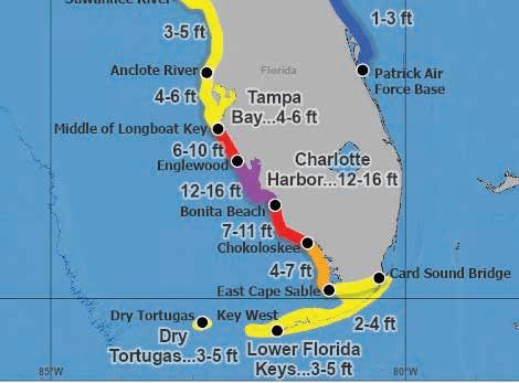
A new forecast graphic experiment by the National Weather Service dating back to the 2020 storm season will go operational in 2023. When watches or warnings take effect in an area, this graphic will be released to depict the peak storm surge, the water above normally dry land, that’s forecast following an advisory. According to the NHC, a graphic depicting the peak storm surge forecast will be released 15 minutes after an advisory.
Tropical Weather Outlook Extends To 7 Days
During hurricane season, the NHC provides a tropical weather outlook graphic that shows potential for a tropical cyclone formation. In 2023, the period covered by the outlook will extend from five days to seven days. Now, the NHC will provide two-day and seven-day outlooks to give residents and local officials more time to plan and prepare.
Live Streams
The National Hurricane Center said it is providing simultaneous live stream broadcasts via its YouTube, Facebook and Twitter accounts where there is an area of interest in the tropics that may pose a threat to land. Live streams will be provided more frequently when the media pool is activated. The media pool is typically activated when a hurricane watch is issued for any portion of the U.S. contiguous coastline.
Shelter Locations
CATEGORY 1-2
HURRICANES
• Key West High School
2100 Flagler Avenue
• Sugarloaf School
MM 19, U.S. 1
• Marathon High School
MM 50, 350 Sombrero Beach Rd.
• Coral Shores High School
MM 90, U.S. 1
CATEGORY 3-5
HURRICANES
Shelter Rules
› You can register onsite.
› Residents will be assigned to a space.
• The E. Darwin Fuchs
University campus. Take the Fair & Expo Center.
• The E. Darwin Fuchs Pavilion, located adjacent to Florida International University campus. Take the Florida Turnpike north and take Exit No. 23. Follow the ramp right toward SW 40th Street (Bird Road). Bear left onto SW 117th Avenue. Turn right onto SW 40th Street. At SW 112th Avenue, make a left to head north and continue until you see signs for the Miami-Dade County Fair & Expo Center.

› No weapons, alcohol or illegal drugs.
› No smoking allowed in shelters.
› “Lights out” quiet time will be enforced.
› All county shelters are also pet-friendly. Animals must have appropriate crates and carriers, plus supplies. With the exception of service animals, pets may be kept in a separate area of the shelter. Pet owners will be allowed to visit pets as necessary, one at a time.
› Children must be attended at all times. Parents are not allowed to leave the premises without them.
Shelter Supplies
› Water and food (multiple-day supply).
› Drinking water in plastic containers.
› Non-perishable food in cans or sealed containers.
› Special dietary foods, baby food, formula, manual can opener, paper products, utensils.
› Portable ice chest with ice.
› Clothing and bedding.
› Extra clothes and shoes.
› Sleeping bag, blanket, pillow, lightweight portable lounge chairs.
› Rain gear.
› Wash cloths, towels, soap, toothbrush, feminine products, paper towels, toilet paper.
BABY AND MEDICAL SUPPLIES
Baby And Medical Supplies
› Clothes, diapers, formula, bottles, food and blankets.
› Medications and first aid supplies.
› Medication clearly marked with your name, dosage, type of medication and doctor’s name. Persons must be able to self-administer all medications.
› First aid supplies in a waterproof box.
IMPORTANT PAPERS
› Name and address of doctors.
› Name and address of nearest relative.
› Identification and valuable papers.
Miscellaneous
› Games, cards, toys, battery-powered radios, flashlights.
› Games, cards, toys, battery-powered radios, flashlights.
› Shower and eat before leaving home.


By Mandy Miles


