12 minute read
A journey along the awa

K A T H Y H U N T E R E X P L O R E S T E A U A U N G A – O U R A W A , O R W A T E R W A Y – T H A T I S N O W B E C O M I N G A P L A C E F O R O U R C O M M U N I T Y TO GATHER AND PLAY
This is a story about the longest urban stream in our city and the amazing amenities and parks in our backyard. The awa runs nearly 14 kilometres from its source near Puketapapa across Tāmaki Makaurau to the Waitematā Harbour. Once upon a time, this awa – Te Auaunga or Oakley Creek – was run-down, locked within concrete and covered in rubbish and weeds. Now, thanks to the tenacious efforts of many people and organisations, it’s being regenerated and encouraged to shine.
Advertisement
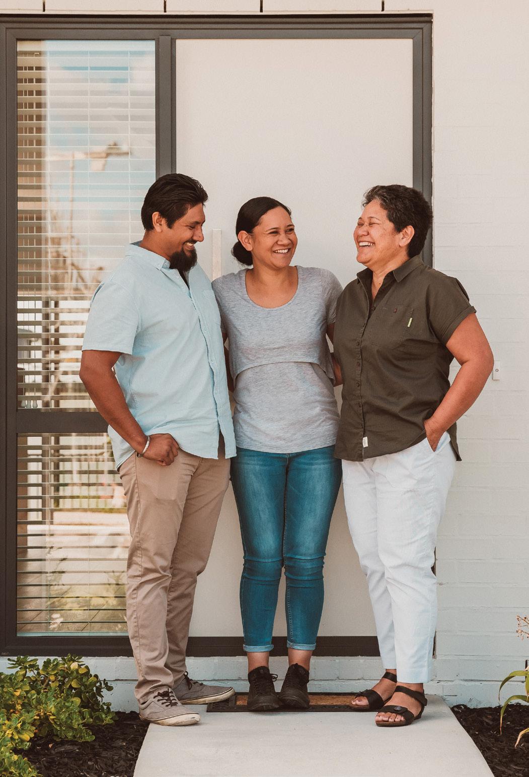
We spoke to some of the team behind the work in Roskill, Development Managers for Roskill Development, Lucy Smith and Aileen Maniti, who have shared their favourite spots along the awa.
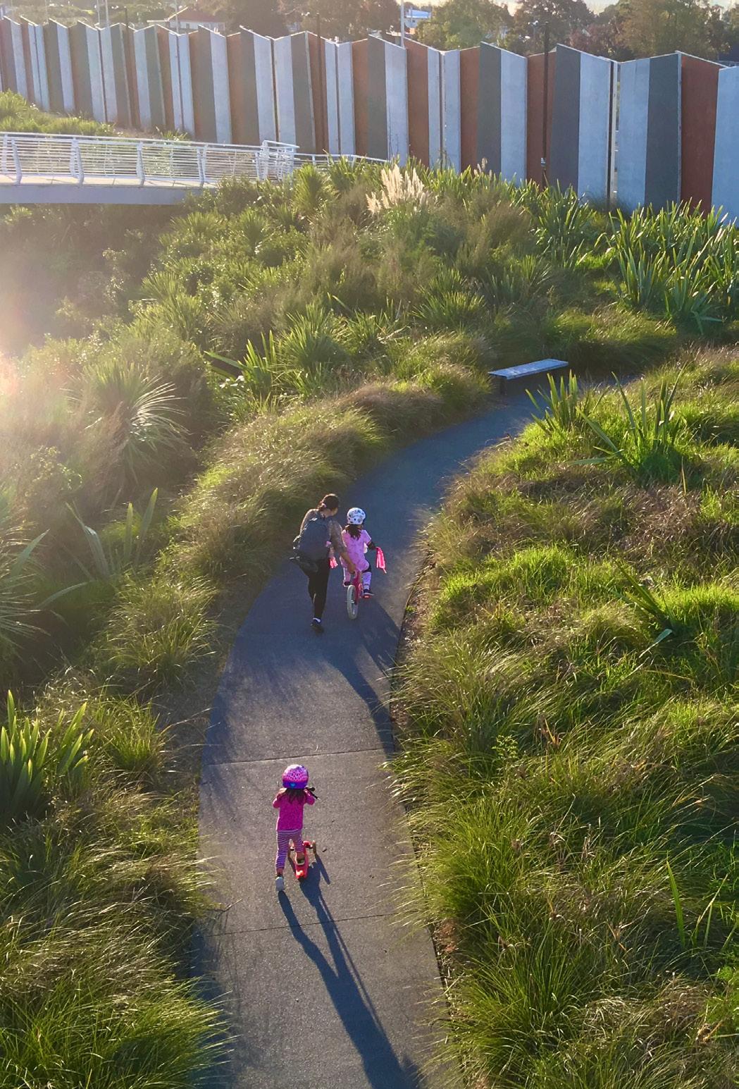
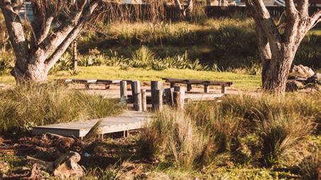
It’s not suitable for swimming, but there are large areas of native planting along the banks of the open stream now, and wide pathways connected by beautiful bridges and picnic spots. There’s an outdoor classroom, community fāle, imaginative play areas based on ancient Māori traditions, special bike and skate parks, many sports fields, and even Auckland’s highest urban waterfall.
Designing the newly built elements along Te Auaunga has brought together brilliant landscape designers and architects, mana whenua, the local community, local boards, Kāinga Ora, school children, artists and Auckland Council.
The awa’s story is all about connections: walking and cycling connections, connections that are cultural, social, practical, playful and have extraordinary ecological benefits. Te Auaunga is now part of a multi-award winning, shared backyard. Join us on a tour through some of the enviable amenities it has to offer our expanding community.
ŌWAIRAKA MT ALBERT
WATERVIEW PATH
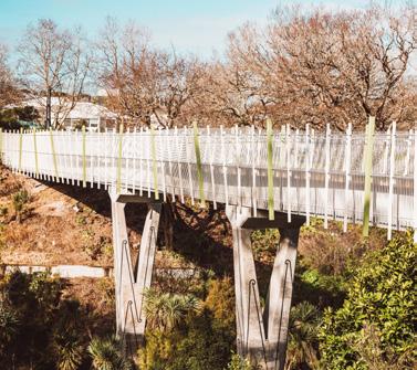
Our story begins just outside the Roskill Development Precinct at the magnificent Te Piringa Bridge over Te Auaunga, which links Great North Road to Unitec. High-tech engineering combines with beautiful Māori design here; look for the seven-metre waka maumahara or carved memorial pillars at the Unitec end. And don’t forget to peer over the edge for your first sight of the awa.
This section of the awa is home to central Auckland’s biggest waterfall – six metres of rushing water tumbling into a deep pool. You can’t swim there, but it’s a great spot to relax and let the falling waters of Te D O M I N I O N R O A D Auaunga soothe you. Back up at Te Piringa Bridge, if you’re on a bike and head south-east you’ll soon arrive at Phyllis Reserve, the home of the Metro football club, then Harbutt Reserve which is charming with its shady trees and playground. A swoop over Soljak Bridge above the railway line takes you to New North Road where your path continues via Alan Wood Reserve, directly opposite.
The Alan Wood to New Windsor path will take you through landscaped fields bounded by mature trees. The way diverges to give the option to walk or ride on a smooth, paved path, or lower down on a gravel track beside the sparkling awa. Keep your eyes open for kōtare (kingfisher), ducks and pūkeko here.
There are several bridges along the way, leading out into surrounding suburbs – they provide splashes of bright colour. The blue bridge is called Tuna Roa bridge after the endangered longfin eels in the awa, purple Mokomoko bridge is named after the native copper skink and the green Raupō Bridge reminds us of the bulrushes which had so many uses in ancient times.
HOW TO GET THERE: Te Piringa Bridge is on Great North Road, across the road from Alford Street. There are five pedestrian entrances to the Te Auaunga Oakley Creek Walkway to reach the waterfall: one at the very beginning of the track close to the motorway on Great North Road; one via steps beside the huge ventilation stack of the Waterview Tunnel close to the BP station, one opposite Alverston Street. in Waterview, one from Unitec and one behind the Metro football clubrooms at Phyllis Reserve.
TE TĀTUA-A-RIUKIUTA BIG KING
T E A U A U N G A WAT E R FA L L
PUKETĀPAPA MT ROSKILL
TE PIRINGA BRIDGE
TE WHITINGA BRIDGE AND VALONIA SKATE PARK
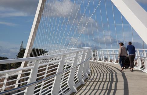
The elegant white curves of Te Whitinga bridge (The Crossing) soon appear against the skyline. Designed by architects Warren & Mahoney, it has a floating appearance due to the offset alignment of the towering arch overhead and the bridge itself; the curve echoes the bulk of nearby Ōwairaka (Mt Albert).
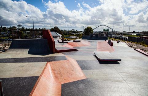
Te Whitinga will take you across State Highway 20 to Kūkūwai Park (named for the wetlands that used to be in the area) where you can continue east toward Mt Roskill. But first check out Valonia Skate Park at New Windsor, a short distance past the entrance to the bridge. Note the new plantings in Valonia Reserve.
This series of skate bowls, banks, quarter pipes and rails is aimed at intermediate to advanced board riders and is inspired by Tāmaki Makaurau’s volcanic landscape. It’s coloured in stripes of scoria-rock grey and lava-red, with the occasional strip of scarlet along edges of bowls and rails like molten magma breaking through the earth’s crust.
HOW TO GET THERE: You can reach Te Whitinga Bridge from Barrymore Road and access Valonia Skate Park from the top of Valonia Street, off Richardson Road.
TE WHITINGA BRIDGE
VALONIA SKATE PARK
ŌWAIRAKA MT ALBERT
MĀRA HŪPARA PLAYGROUND AND PUMP TRACK
Over Te Whitinga bridge and through Kūkūwai Park you’ll soon swoop under Richardson Road underpass to Underwood Park and a very special playground. It looks at first glance like a pile of huge logs, but it’s much more than that. It’s an example of a traditional ancient Māori playground, a Māra Hūpara, designed by historian Harko Brown.
Games involving Māra Hūpara in ancient times were an important part of society. They were an essential part of rituals and initiations, and were often interwoven with stories, waiata and celebrations. This playground is a scaled-down version of what may have been around a few centuries ago, D O M I N I O N R O A D but incorporates the same elements. “Kōkiri are huge raised logs, which in ancient times could be 20 metres long,” says Harko Brown. “Villagers would run along and jump off, often into water. They could also be used as bridges to traverse marshy areas, or to climb into trees to set bird traps.
“Rock walls or natural rock formations are wera-te-paatu. These, with kōkiri, were used in kaipara (a form of athletics), para whakawai (weaponry training) and more. They were also places of contemplation, creativity, discussion, speech-making and especially education. As learning tools, I’ve taught maths, science, and physics using them,” Harko says.
There are also groups of hikeikei, short vertical posts, to hop across, teaching agility, risk assessment and confidence. For kids, the whole hūpara offers a fun way to engage with the environment and history at the same time. Everything used here is found or recycled – the enormous kauri stumps supporting the logs had been sitting in a yard in Takanini for years before finding their home here.
A little further along on your left is a new bridge connecting Te Auaunga to the open spaces of Ōwairaka Park and Hendon Avenue. Here you’ll find sports fields, a playground, flying fox, basketball half-courts, a skate park, toilets and even a thriving community garden.
Further along you’ll come across a bike and skate pump track for younger kids (and sometimes their parents, too!). Mum and Dad can relax and watch from stylish and shady picnic tables and seating under huge fig trees.
HOW TO GET THERE: You can access the Māra Hūpara Playground and Pump Track in Underwood Park from Wainwright Avenue.
TE TĀTUA-A-RIUKIUTA BIG KING
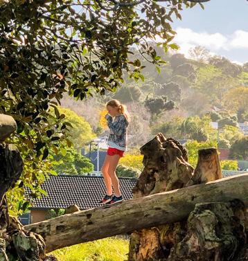
MĀRA HŪPARA PHOTO COURTESY OF @HALSTONKITCHEN
PUKETĀPAPA MT ROSKILL
An exuberant building is immediately obvious in Walmsley Park. This fāle is a collaboration between contemporary Tongan artist Sopolemalama Filipe Tohi and McCoy & Heine Architects.
Felipe Tohi is a master of lalava, the symbolic and powerful art of binding together a building or vessel using braided cords in patterns. You’ll see examples of this at the tops of the fāle posts.
The zigzag forms of the kupenga, or net, is a motif used throughout this section of Te Auaunga thanks to the artist – you’ll notice the kupenga design in the beautiful new tables and bench seats, the boardwalks, even the wharepaku (toilets) close by.
Opposite the fāle is an island, reached by rocks across the stream or from the other side via a zigzag boardwalk. A group of bench seats make a perfect spot for lessons in environmental design in an outdoor classroom surrounded by lush regenerative plantings.
HOW TO GET THERE: You can reach the Fāle and Outdoor Classroom in Walmsley Park from pathways off Aurora Avenue and O’Donnell Avenue (opposite Wesley School).
FĀLE
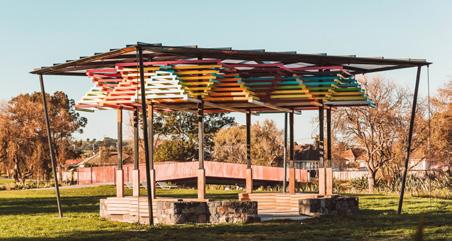
O U T D O O R C L A S S R O O M
WESLEY COMMUNITY CENTRE
This is the home of the famous Wesley Market every Tuesday and Friday from 7am-12.30pm. There are rooms available for hire, a playgroup, kids’ holiday programmes, and language and fitness classes. It’s also your point of contact for health, legal, and budgeting services.
Outside the Wesley Centre, you can’t miss the Bike Kitchen container. This wonderful team of cycle enthusiasts fixes up old bikes and passes them on to those who need them in the community.
They have free workshops for kids every fourth Saturday – the Bike Kitchen team will teach you how to maintain and fix your old bike or build one from scratch.
HOW TO GET THERE: You’ll find the Wesley Community Centre and Bike Kitchen at 740 Sandringham Road Extension, Mt Roskill.
ŌWAIRAKA MT ALBERT
One of the area’s largest and busiest facilities, Keith Hay Park is super-sporty, with football, cricket and basketball amenities, plus the Cameron Pool & Leisure Centre, managed by the YMCA. It’s also the home of Three Kings United, one of Auckland’s biggest football clubs, and Tri-Star Gymnastics, which MT ROSKILL A playground includes in-ground trampolines and a huge climbing net and there’s an easy walking and cycling path around the perimeter of the park. HOW TO GET THERE: You’ll find the Cameron Pool and Leisure Centre at 53 Arundel Street, Mount Roskill. Arundel Street also has access to Keith Hay Park. Between Sandringham Road and May Road lie the wide-open spaces of War Memorial Park. At the May Road end, you’ll find sports clubrooms, a community hall, playground, skate park, basketball courts and softball diamonds, plus free outdoor exercise equipment.
Don’t miss Te Hīnaki, a spectacular bridge which leads to Gifford Avenue and on to Mt Albert Road. Its tunnel shape is a modern interpretation of a woven hīnaki or eel-trap, complete with shining tuna (eels) swimming into it. In ancient times, this area was swampy and hīnaki would have been in constant use to feed local mana whenua.
Te Hīnaki also refers to the story of Maui, the hero of ancient Māori folklore, whose wife was being harassed by a giant eel named Tuna-Roa on her daily D O M I N I O N R O A D his wife and chopped him up; legend says that the pieces of his body became freshwater eels and his tail became the marine-dwelling conger eel. HOW TO GET THERE: You can reach Hinaki Bridge from Gifford Avenue. Cross the bridge and you’re in War Memorial Park.
KEITH HAY PARK
caters to all levels of gym enthusiasts. PUKETĀPAPA
trip to collect water. Maui killed the eel for insulting
TE TĀTUA-A-RIUKIUTA BIG KING
TE HINAKI BRIDGE
The future of Te Auaunga
At the south end of the awa, Freeland Reserve near Pukewīwī/Puketāpapa/
Mt Roskill is earmarked for an upgrade. Lucy Smith, from Kāinga Ora’s Roskill
Development team, says, “We’ll be daylighting the stream, installing boardwalks and pathways and planting lots of natives to make a beautiful community amenity.” Further into the future, consideration is being given to linking Keith
Hay Park to Waikōwhai Park.
North-west near Ōwairaka/Mt Albert, around 1000 new homes will replace 200 old, unhealthy state houses. “We’re currently working on improving greenways and connections within Ōwairaka to make them more usable and safe for residents,” says Aileen Maniti. Community ideas range from new play areas, improved lighting, seating and pedestrian access to a food forest. They’ll be looking to link Kūkūwai Park to Murray Halberg Park rugby fields and beyond.
Sustainable connections The restoration of Te Auaunga is an Auckland Council’s Healthy Waters project in partnership with Fulton Hogan, Boffa Miskell and AECOM. The project won many awards for sustainability in 2019. It reduced flooding, improved water quality and involved community and iwi. Project Manager Tom
Mansell said; “At every opportunity, we sought ways to deliver tangible cultural, social, economic and environmental benefits.”
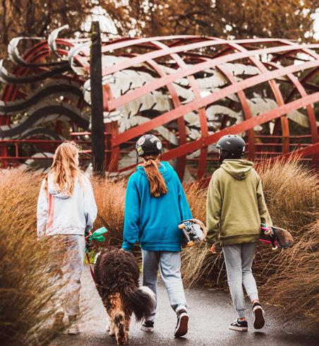
Locally, Te Auaunga means you can travel sustainably around the Roskill area. But as Jolisa Gracewood of Bike Auckland says, it’s part of a much bigger story. “From Waterview, on a bike, the Northwestern Cycleway can take you safely as far west as Westgate, or right into the city and down along the waterfront. You can even take your bike on a train or ferry at no extra cost – so maybe Devonport for the day!”
Margi Watson, chairperson of the Albert-Eden Local Board, and one of the advocates of Te Auaunga’s restoration, sums it up. “Te Auaunga has been part of our community for generations. But now it connects our neighbourhoods with beautiful new spaces to relax, breathe and play. Huge credit must go to those who made and continue to make it happen, and to the communities and volunteers who care for our awa.”
MEET SOME OF THE TEAM
AILEEN MANITI
DEVELOPMENT MANAGER, ROSKILL DEVELOPMENT

LUCY SMITH
DEVELOPMENT MANAGER, ROSKILL DEVELOPMENT
T E A U A U N G A I S A S A F E A N D S U S TA I N A B L E WAY TO TRAVEL AROUND THE ROSKILL AREA.