Programs and Impact Report
Updates
Chesapeake Conservancy
Febraury 2026 Board Meeting
Conservation Innovation Center February 6, 2026
Emily Beach
• The work on the EPA Landscape Characterization and Monitoring in the Chesapeake Bay Watershed project continues to run on time and within budget. We have been notified that the EPA is proceeding with incremental funding of $400k for Year 2 (total for Year 2 is $1.3M). We have submitted all required documents and are waiting for the updated Cooperative Agreement for review. No funds will be dispersed until the Notice of Award is signed by the EPA Award Official and issued by the EPA Region 3 Grants Management Office We expect to receive full funding for Year 2, but this is contingent EPA funding availability.
• The CIC is hiring two positions:
o Conservation Data Specialist – this position will directly support the CIC’s Business Plan product development.
o Chesapeake Data Project Manager – this position will manage the EPA Landscape Characterization and Monitoring in the Chesapeake Bay Watershed project.
• Working with an attorney to establish legal documents and procedures specific to the CIC but with Conservancy-wide use:
o Non-Disclosure Agreement (NDA) – received, in review
o Contracts
o Service Agreement
Accomplishments
• The Conservancy was awarded a contract with the Blue Ridge Parkway Foundation for $180k to conduct a viewshed and conservation analysis along the 469-mile Blue Ridge Parkway in Virginia and North Carolina. The primary goal of this work is to determine which lands and waters within the viewsheds of scenic overlooks currently lack conservation status should be prioritized for conservation and landowner outreach. This is a great example of how the CIC can acquire work outside the watershed while building new skills that we can expand on within the watershed.
Challenges
• While we have initially secured Year 2 funding from the EPA, we anticipate reduced funding with the potential removal of specific activities in Year 3.
To: Chesapeake Conservancy Board of Directors
From: Carly Dean, Director of the Chesapeake Tributaries Initiative
Date: February 2026
Subject: Chesapeake Tributaries Initiative status & plans for growth
Key program updates
To date, agricultural restoration targets for 13 PA streams have been met toward delisting. In 2026, we secured PA state funding ($400K) and a federal earmark ($300K) for on-the-ground restoration. Stream delisting data analysis is underway in four new PA counties and the team is finalizing contracts to scale delisting to five new PA counties ($100K) and one new MD watershed ($50K). A February meeting is planned with MD DNR’s program lead for the Whole Watershed Program to finalize a partnership plan. A total of forty-six people have received paid, on-the-job conservation training through the Gather & Grow program and three micro-nurseries were established to grow native plants for restoration projects
Plans for growth
To add MD capacity to the Tributaries team, interviews are underway/planned for two new positions--a project coordinator/GIS analyst staff member and a full-time, one-year position through the Chesapeake Bay Trust Chesapeake Conservation and Climate Corps program.
Two NFWF proposals are underway to replicate the delisting program in one new PA county in ($100K) and two new MD counties ($80K). The team is developing a PA land protection strategy to protect investments in restoration in stream delisting catchments through preservation and conservation. The team developed a concept to complete a Bay-wide analysis using AI to prioritize land protection in streams that are currently impaired but improving or not impaired but declining.
To: Chesapeake Conservancy Board of Directors
From: Land Protection Task Force
Date: February 17, 2026
Subject: Approval of the Chesapeake Conservancy’s Land Protection Strategy
Dear Board Members,
The Task Force is submitting the Land Protection Strategy for approval by the Broad. The approach to develop the strategy followed the charter that the Board approved in February 2025. Progress on the strategy was brought to, and feedback received, during each Board meeting in 2025. The Broad’s feedback helped the Task Force with the scope and recommendations of the strategy. The Board’s review and comments of the draft strategy in December 2025 improved the final document. A summary of the comments from the Board on the draft strategy and the Task Force responses and revisions are provided below. We look forward to your approval and working with Conservancy leadership to consider and implement the recommendations.
Sincerely,
The Land Protection Task Force
● Chairperson: Scott Phillips
● Vice-Chair: Stephanie Vaughn
● Board Members: Astrid Caldas, Philip Tabas and Mike Reynolds
● Board Advisors: Rich Batiuk and Stephanie Meeks
● Conservancy Staff and Consultants: Mike Evans interfaced with Conservation Innovation Center (CIC) on mapping support. Chase Douglas provided input about the Chesapeake Conservation Partnership and meeting support. Andy Lacatell consulted on developing and reviewing the strategy Susan Shingledecker provided input after she was hired as CEO.
We also appreciate the illustrations being prepared by Jody Couser, input from Emily Beach on the CIC decision tool, and Carly Dean’s comments on the Tributaries Initiative.
Comments from Board and Task Force Revisions to the Strategy
This document summarizes the review comments of the Board on the draft Land Protection strategy that was provided in December 2025. The comments are organized around the recommendations of the 3 sections of the strategy: What, How, and Where. Additionally, the document includes findings from follow-up meetings with the Conservation Innovation Center (CIC) about mapping approaches that are critical to include in the strategy
The Task Force has developed responses and revisions to address each of the Board’s comments. These revisions were incorporated into the final strategy being submitted to Board for approval at their Feb 25, 2026, meeting.
Board Comments in Section 1 of the Strategy.
Section 1 recommendations are for “what” the strategy will cover: goals and criteria for land protection. The Board had comments on each recommendation, with most of the feedback on the second and third recommendations.
Create a goal statement for the unique role of the Conservancy in land protection.
• Board comments: overall the Board agreed with the Goal statement. There was a specific comment for the term “current and” new data to identify high-value lands.
• Task Force response and revision: Modified the goal statement.
Adopt selected outcomes of the Chesapeake Bay Program as measures of success.
Board comments: The Board had mixed reactions to adopting selected outcomes of the new Chesapeake Bay Program (CBP) agreement, especially the target of 2 million acres by 2040 Overall, the Board wants to support the CBP land conservation effort but thought there should be a more aspiration goal in the Conservancy strategy. Some Board members wanted to stay with current target of the Conservancy, and the Chesapeake Conservation Partnership (CCP), of protecting 30 percent of the watershed by 2030. However, the Task Force shared that reaching the 30x30 goal is a challenge according to the CCP 30x30 dashboard. Information on the dashboard says, “the current rate of land conservation is 126,000 acres per year” and “a rate of 415,000 acres per year is needed to meet the 30 x30 goal” (see link below). Finally, there was discussion that the 30x 30 goal has an uncertain future because of changing priorities of the federal government https://chescon.maps.arcgis.com/apps/dashboards/5979e716b18144c989b884bb437dffd2
• Task Force response and revision: Given the uncertainty of the 30 x30 goal, and the Board’s desire to have a more robust target than the CBP goal of 2M acres by 2024, the Task Force suggests not having a specific land protection target in the strategy. The recommendation will be revised to "Update the Conservancy’s land-protection targets to support evolving partnership efforts across the watershed”. The strategy was updated to discuss selected outcomes the CBP has adopted and potential Conservancy support, and continued Conservancy leadership of CCP conservation efforts. The strategy suggests that the Conservancy update land protection targets in the future, perhaps as part of updating the
overall strategic plan for the organization. Additionally, the strategy also discusses that the Conservancy is putting more emphasis on the quality of lands being protected, not just the amount, so we have developed criteria for high-value lands.
Establish a process and criteria for land protection.
• Board Comments: This recommendation had a robust discussion and comments. The comments included that the recommendation needs more focus and should generate more excitement. There was also a concern that we have too much emphasis on water quality and not enough on flora and fauna. Finally, some Board members said the Task Force should consider additional criteria, including biodiversity and endangered species.
• Another topic was how to better tie together the Conservancy’s land protection efforts with stream restoration. The text saying that land protection is “focusing on streams not on the impaired waters list” was taking away from the Conservancy’s work to delist streams.
• Task Force response and revisions: The Task Force understands that members of the Board will have different views on the criteria for land protection, because the Task Force also had similar discussions. However, the Task Force was directed to develop a concise list of priorities for land-protection efforts. To address the Boards comments, we recommend:
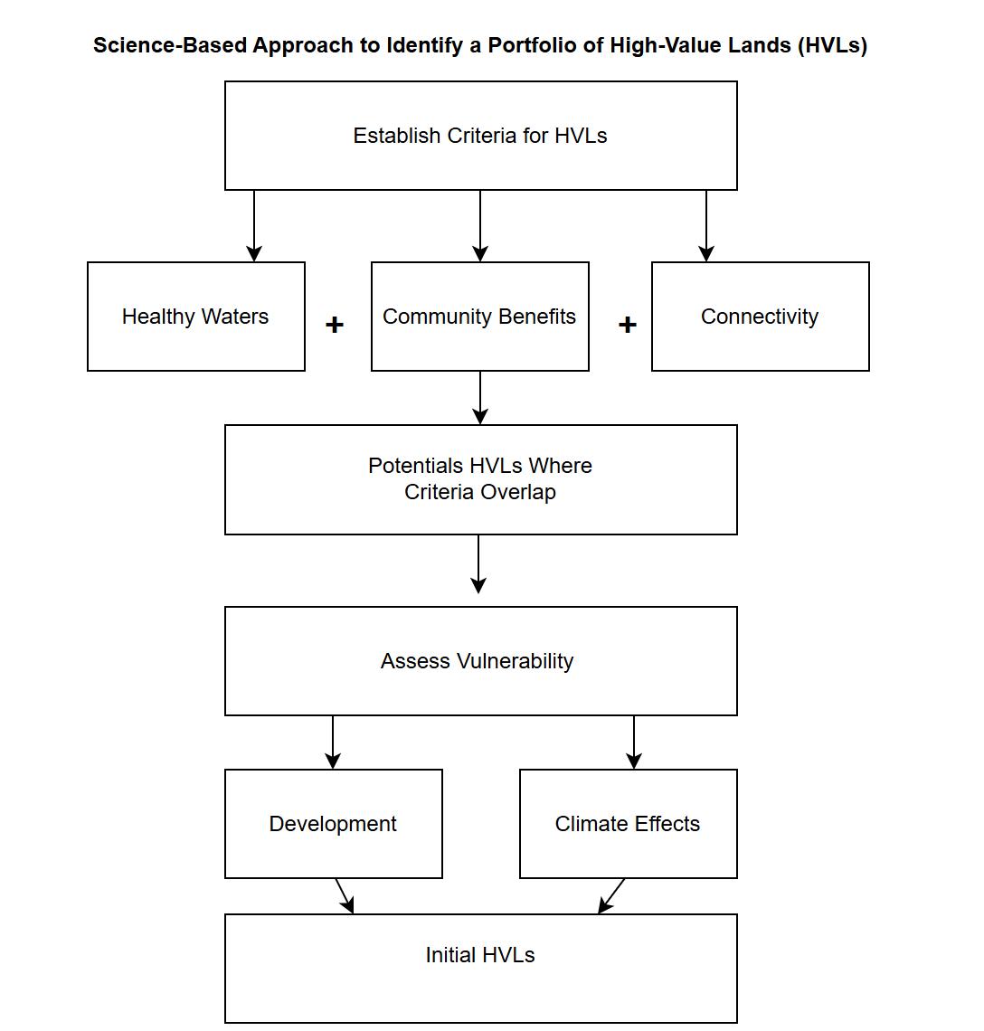
o Maintaining the criteria identified as most important for high-value lands: (1) protect healthy waters, (2) provide community benefits, and (3) enhance connectivity. The high-value lands will be further assessed for their vulnerability to development and/or climate effects.
o Adding a discussion about potential additional benefits of high-value lands. Once the high-value lands have been identified, the Conservancy can discuss with partners how these lands may provide additional benefits, such as biodiversity, endangered species, habitat, and cultural heritage. Having this information will strengthen the case for pursuing selected high-value lands and their importance to partners who could help the Conservancy acquire the lands and ensure their long-term protection
o The strategy was revised to address the relation between protecting lands and restoring water quality. The revised text reflects that as the Conservancy works with partners to restore water quality in streams (Tributary initiative); the surrounding lands could be protected to maintain the improved health of restored streams.
Create alignment between the Conservancy Land Protection Strategy and Giftlands Program.
• Board Comments: The Board had varying opinions about how much alignment there should be between the using the criteria in the new strategy to assess all land opportunities brought to the Conservancy, either directly by a partner, donor, or through the Giftlands program. While the Board agreed with the concept of using the criteria for high-value lands to assess opportunities brought to the Conservancy, they still wanted flexibility to consider land acquisitions
• Task Force response and revisions: The Task Force feels the Conservancy should be more strategic in assessing the lands for protection and will keep the text recommending that any lands brought to the Conservancy for protection should be assessed using the criteria for
high-value lands. The Conservancy leadership and Board can still decide to pursue opportunities that do not address the high-value land criteria based on their discretion.
Increase the Conservancy’s profile by seeking Land Trust Accreditation.
• Board Comments: Add information about the time and expense of seeking the accreditation.
• Task Force response and revisions: This information was added.
Board Comments on Section 2 of the Strategy
Section 2 focuses on the “How”, organizational changes the Conservancy need to consider for implementing the strategy
Establish a team dedicated to land protection.
Board Comments:
• Discussions are still occurring about the overall organizational structure of the Conservancy. The placement of the land protection team is anticipated to be housed where programs are grouped, including the CIC and Tributary Team. Susan Shingledecker is still working on the final structure
• Susan Shingledecke and Scott Phillips discussed the need for the Land Protection team to be more engaged in the CBP groups overseeing land conservation: the healthy landscapes goal team and the protected lands workgroup. While this need was reflected in the strategy, the Conservancy currently does not have staff, or a funding source, to support greater interaction with the CBP.
Task Force response and revisions: Susan will make the final decision on where the Land Protection Team is placed in the Conservancy’s organizational structure. A simplified organizational chart is included in the strategy that shows the anticipated land protection team and that it will collaborate internally with other teams
Create two new full-time positions: land protection director and land transaction specialist.
• Board Comments: The primary comments by the Board were about the large scope of responsibilities of the new Land Protection Director and the potential salary requirements.
• Task Force response and revisions: The salary estimate for the Director was increased, but hiring issues are best addressed by Conservancy Leadership
Develop a sustainable funding plan for land protection efforts.
• Board Comments: There were concerns that the current estimates of Conservancy’s land protection efforts (about 200K) may be too low because of very reasonable costs of some consulting services.
• Task Force response and revisions: The strategy was revised to increase the salary estimate of the Land Protection Director to 150K and the reasonable costs of some consulting services were noted. However, meeting salary demands is a Conservancy leadership and Board issue and does not require added text in the strategy.
Comments on Recommendations in Section 3
There was discussion about if the strategy should identify places to focus Conservancy efforts and the mapping approach to identify high-value lands.
Use a science-based approach to identify and inform priorities for high-value lands.
Board Comments and CIC input:
• Some Board members wanted the strategy to address the original charge of the Task Force charter to identify 5-10 places to focus Conservancy efforts for land protection. Some suggested a “top 10 rivers in the watershed” to be protected. They want the mapping approach to be able to identify places with clusters of high-value lands, so the Conservancy can focus efforts across the watershed. These discussions are also tied to the suggestions in section 1 to have more focused criteria.
• Board members seemed concerned that the proposed mapping approach (based on Mike Evans’ Pollution Prevention example in Dragon Run of parcel-level analysis) presented too many parcels to consider and needed to be refined.
• A follow-up meeting was held with the CIC leadership (Emily Beach and Mike Evans) and Susan Singledecker, Rich Batiuk and Scott Phillips on December 19 We discussed mapping approaches and what was feasible to include in the strategy and what future efforts should be. We agreed on the desire to map and make decisions at the parcel scale and apply the innovative approaches for calculating nutrient and sediment prevention. However, Emily shared that constructing a parcel-level decision tool with these innovations would be a one to two-year endeavor.
• Emily proposed we consider utilizing the current CIC Land Protection Decision Tool as an initial step for mapping high-value lands and associated priority watersheds. The tool had been discussed during early meetings of the Task Force but had not been emphasized since the Task Force became more focused on parcel-level analysis.
• The current CIC tool has 5 topic areas: biodiversity, climate impacts, healthy waters, equitable access, and cultural heritage. We discussed how the tool could be modified to assess the criteria developed by the Task Force for high-value lands: protect healthy waters, promote community benefits, enhance connections, and then assess vulnerability to development and climate change
• The CIC made modifications to the tool and presented it to Task Force to discuss opportunities. We also discussed the challenges and opportunities of using the tool to identify clusters of high-value lands and associated priority watersheds However, we concluded that identifying places to focus cannot be done within the timeframe of completing the strategy. Further, this function would should be done by the Conservancy Land Protection Director and team, not the Task Force or the Board.
Task Force response and revisions:
• The recommendation to use a science-based approach was rewritten to reflect discussions with the CIC and address the Board’s comments.
• The recommendation for a science-based approach will be conducted in two phases
o Phase One: Modify the CIC Land Protection Decision tool with available data to identify high-value lands and priority watersheds
o Phase Two: Build a parcel-level tool for more qualitative ranking of high-value lands.
• Phase 1 of the mapping would use a modified version of the CIC Land Protection Decision Tool. The CIC is making modifications to match our Task Force criteria for high-value lands, and section 3 of the strategy was rewritten to provide details
• Phase 2: Improve parcel-level data and develop a new tool for more qualitative ranking of high-value lands. This phase would reflect developing and evaluating ranking parcels for protection, such as the pollution preventions approach presented by Mike Evans. During a call (Jan 9) with the CBP Geospatial Team and Healthy Landscapes leadership, they supported the need to make decisions at the parcel scale but recognized some data sets for parcel-scale analysis need improvement. The CBP has an interest in working with the Conservancy to improve these data sets and their application in decision making. The CIC provided updated costs of $175,000 in year two to build a parcel-level tool. The costs are explained in section 2 of the strategy and the approach for the tool in section 3.
• The Task Force feels that initial high-value lands and priority watersheds are best identified when the new Land Protection Director is hired and their team established Section 3 was rewritten to propose how Conservancy can undertake this process.
• Choosing high-value lands and priority watersheds should be dependent on the Conservancy capacity. Section 3 was rewritten to describe how the Conservancy would focus on a limited number of priority watersheds, each with HVLs, based on the capacity of the Land Protection team.
Have Conservancy staff, leadership, and Board finalize high-value lands to pursue
Board Comments:
Susan Shingledecker shared that the table with financial thresholds and approvals needs to be modified. In the step for engaging partners, Susan suggested less emphasis on working with the CCP and more on interaction with individual members and new partners. Additionally, we need to reflect in the engaging partners step about opportunities to work more closely with the CBP.
Task Force response and revisions: Section 3 was updated to address her suggestions.
Summary of the Chesapeake Conservancy’s Land Protection Strategy
The Chesapeake Conservancy was established in 2011 to focus on protecting lands across the Chesapeake Bay watershed. Since the Conservancy was established, almost 2 million acres of land have been protected through 2024. The protection was achieved through efforts by federal state, and local agencies, non-governmental organizations, land trusts and private donors. The Conservancy has worked with many of these partners to complete projects that serve multiple functions, including important additions to existing parks and natural areas and cornerstone projects to facilitate larger conservation actions, such as establishing the Southern Maryland National Wildlife Refuge. While these projects each have their own value, the Conservancy desired a more strategic approach to identify and protect what we consider the most important lands across the Chesapeake watershed.
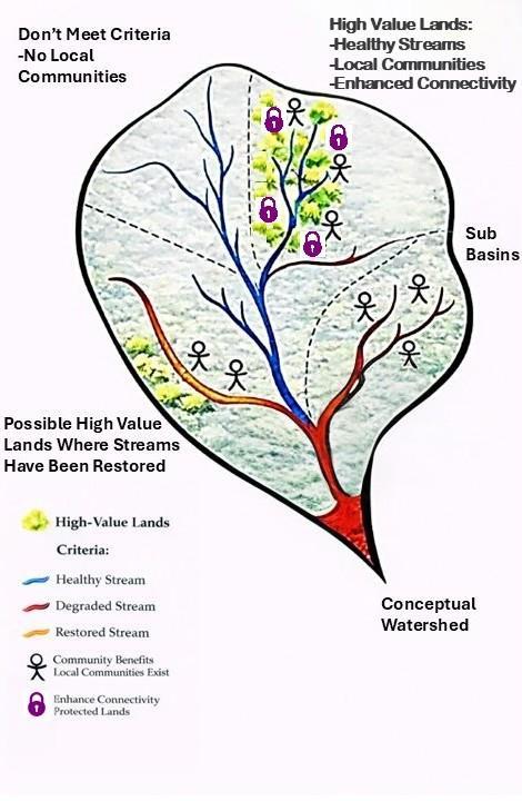
With that in mind, the Conservancy’s Board of Directors charged a Task Force (see Appendix A) to develop a Land Protection Strategy. The Strategy has new ideas and approaches to focus on high-value lands (HVLs) providing benefits to people and nature across the Chesapeake watershed. These lands will be identified based on 3 criteria: protect healthy waters, promote community benefits, and enhance connectivity (Fig S.1). In addition, HVLs will be further assessed for their vulnerability to development and/or the effects of climate change.
Figure S.1: Conceptual diagram of criteria for high-value lands (HVLs). HVLs are where multiple criteria overlap.
The Strategy has the following overarching goal for land protection: The Chesapeake Conservancy will use a science-based approach, utilizing current and new data and technologies, to identify high-value lands that protect healthy waters, promote community benefits, and enhance connectivity, with an emphasis on assessing the vulnerability of lands to development and/or the effects of climate change. The Conservancy will work with agencies, organizations, and donors to acquire, and ensure the long-term protection of, these high-value lands to benefit people and nature across the Chesapeake Watershed.
The Strategy is organized around three topics: Section 1: What the goals of the Strategy and the criteria for land protection; Section 2: How organizational changes to implement the Strategy; and Section 3: Where a science-based approach to focus land protection. Each section contains recommendations (see summary table below), with supporting details provided throughout the Strategy.
Summary of recommendations in each section of Strategy
Section 1: What Goals of the Strategy and Criteria for Land Protection Recommendations
Create a goal for the unique role of the Conservancy in land protection
Update the Conservancy’s land protection targets to support evolving partner efforts
Establish criteria to guide land protection: High-Value Lands (HVLs)
Ensure alignment between the Strategy and the Giftlands Program
Increase the Conservancy’s land protection profile by seeking Land Trust Accreditation
Supporting information
The goal defines the Conservancy’s unique role to identify high-value lands and work with partners to increase the amount and quality of protected lands across the watershed.
The Conservancy should update targets for land protection and support efforts of the CCP members and the new CBP Watershed agreement to protect an additional 2 million acres of land by 2040.
The three criteria for HVLs are (1) protect healthy waters; (2) promote community benefits, and (3) enhance connectivity. The lands will also be assessed for their vulnerability to development and/or climate change
The Giftlands Program criteria for conserving lands should be updated to align with the criteria for HVLs
Accreditation would enhance the Conservancy’s ability to interact with more donors, landowners, NGOs and public agencies as they apply more sophisticated approaches for land protection.
Section 2: How Organizational Changes to Implement the Strategy Recommendations
Establish a team to lead land protection
Create new positions to establish the Land Protection team
Supplement the team with existing staff to ensure collaboration across the Conservancy
Develop a sustainable funding plan for the Land Protection team.
Supporting information
The team will require collaboration from different groups, representing needed capacities from across the Conservancy, to carry out key functions.
At least two full-time positions are needed to lead the team: (1) Land Protection Director, and a (2) Land Transaction Specialist
The Land Protection team will interact with existing staff from the Conservation Innovation Center, Development, Tributary, Policy, and Finance teams to develop a list and evaluate HVLs.
Funding will be needed for the new positions and contributions from existing staff and consultants. The plan should be developed by the Land Protection Director.
Section 3: Where Science-based Approach to Focus Land Protection Recommendations
Use a science-based approach to identify and help prioritize HVLs
Engage partners and donors on their interest to acquire and protect HVLs
Prioritize and finalize the HVLs and pursue for long-term protection
Supporting information
A science-based approach will be used to identify and help prioritize the highvalue lands using unique high-resolution data produced by the Conservancy and data produced by other partners.
The Conservancy will engage agencies, organizations and donors to gauge their interest in acquiring and protecting HVLs
The Land Protection team will evaluate HVLs and bring individual properties forward for approval. The CEO and the Board would approve the HVLs to pursue. Once approved, the Land Protection team will work with the interested partner(s) or donor(s) to acquire the lands and ensure its long-term protection.
The sections and recommendations are tied together through a 5-step process (Figure S.2)
Figure S.2. Process and steps for the Conservancy’s land protection strategy
● Step 1: Develop an initial portfolio of high-value lands and priority watersheds. The criteria for HVLs are described in section 1, which include (1) protect healthy waters, (2) promote community benefits, and (3) enhance connectivity. The vulnerability of these potential HVLs to development and/or the effects of climate change is also assessed during this step. Priority watersheds, which contain clusters of HVLs, will be identified to focus efforts.
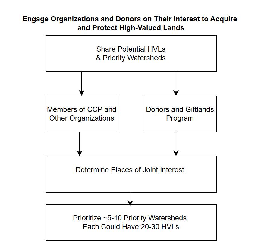
● Step 2: Engage partners and donors. This step would engage organizations and donors to assess which priority watersheds, and the potential HVLs within them, they have an interest in pursuing with the Conservancy.
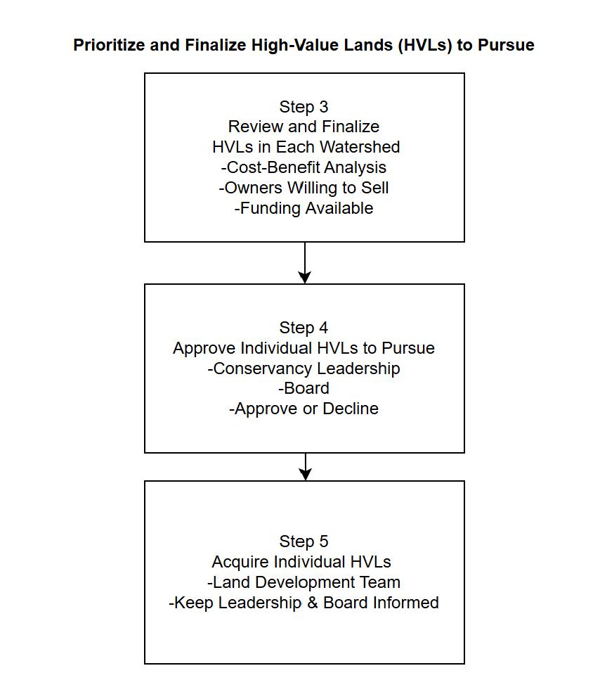
● Step 3: Review and prioritize. The Conservancy would evaluate the costs and benefits of HVLs to prioritize the ones to pursue. The Conservancy would work with partners and landowners to assess which HVLs can be acquired and negotiate the deals for approval.
● Step 4: Approve deals to acquire HVLs lands. The Conservancy CEO and/or Board will approve deals for individual HVL parcels (or ask for more information, or reject)
● Step 5: Pursue, acquire, and transfer high-value lands. After the deal is approved, the Conservancy works with the interested organization(s) and/or donor(s) to acquire the HVL parcel and ensure its long-term protection.
The Conservancy has developed this Strategy so we can be more proactive where land protection occurs. A unique aspect of the Conservancy is that we don’t manage lands, so we can put our energy into identifying and acquiring HVLs, working with partners and donors for their long-term protection. The Land Protection Strategy will allow the Conservancy staff and Board to be more strategic in seeking investments, using staff resources, and collaborating with partners and donors to protect critical lands across the Chesapeake watershed.
Section 1 - What: The Conservancy’s Land Protection Goal and Criteria for HighValue Lands
This section provides the goal for the Conservancy Land Protection Strategy and explains the criteria for high-value lands (HVLs). The Strategy’s goal and criteria were informed by a review of the Conservancy’s current land protection focus and other Chesapeake Bay watershed organizations’ strategies, to ensure our approach complement other partner efforts.
The recommendations discussed in this section are:
● Create a goal statement for the unique role of the Conservancy in land protection
● Update the Conservancy’s land protection targets to support evolving partner efforts
● Establish criteria to guide land protection: High-Value Lands.
● Ensure alignment between the Land Protection Strategy and the Giftlands Program.
● Increase the Conservancy’s land protection profile by seeking Land Trust Accreditation
Recommendation: Create a goal for the unique role of the Conservancy in land protection.
The Task Force’s recommended land protection goal reflects a more proactive approach and reflects the unique role for the Conservancy in land protection across the Chesapeake watershed. The goal emphasizes the quality of lands that should be protected, which are defined as HVLs, based on science and innovation, while working with partners.
The Chesapeake Conservancy will use a science-based approach, utilizing current and new data and technologies, to identify high-value lands that protect healthy waters, promote community benefits, and enhance connectivity, with an emphasis on assessing the vulnerability of these lands to development and/or the effects of climate change. The Conservancy will work with agencies, organizations, and donors to acquire, and ensure long-term protection of, these high-value lands to benefit people and nature across the Chesapeake Watershed.
The land protection goal was developed to align with the overall mission of the Conservancy’s current strategic plan (2023-2030):
To conserve and restore the natural and cultural resources of the Chesapeake Bay watershed for the enjoyment, education, and inspiration of this and future generations. We serve as a catalyst for change, advancing strong public and private partnerships, developing and using new technology, and empowering environmental stewardship.
The Conservancy’s strategic plan has an overall objective for 2023-2030:
To conserve and restore 30% of the Chesapeake Watershed by 2030 with emphasis on landscapes of significant ecological and cultural value, to engage and empower diverse conservation leaders, and build the foundation of an enduring institution.
The Conservancy should consider evolving its current land protection objective (protecting 30% by 2030) as the deadline draws closer (See the next recommendation).
Recommendation: Update the Conservancy’s land protection targets to support evolving partner efforts.
The Conservancy has played an important leadership role in setting land conservation goals for the Chesapeake watershed working with key partnerships, including the Chesapeake Bay Program (CBP) and the Chesapeake Conservation Partnership (CCP). Both the CBP and CCP are evolving their land conservation efforts, so the Conservancy should consider updating our land protection target while continuing to support their efforts.
The Conservancy, working with the National Park Service, established the CCP in 2010 to ensure a coordinated watershed-wide effort for land conservation. The CCP set a goal in 2011 to protect an additional 2 million acres of land by 2025. The Chesapeake Bay Program, a federal-state partnership, adopted this goal in 2014, as part of the Chesapeake Watershed agreement.
The Conservancy and the CCP adopted an additional goal in 2019 to conserve 30% of the Chesapeake Watershed by 2030. The expanded goal was in response to national and international efforts, when 190 nations at the UN Conference on Biodiversity, pledged to conserve 30% of their respective lands by 2030.
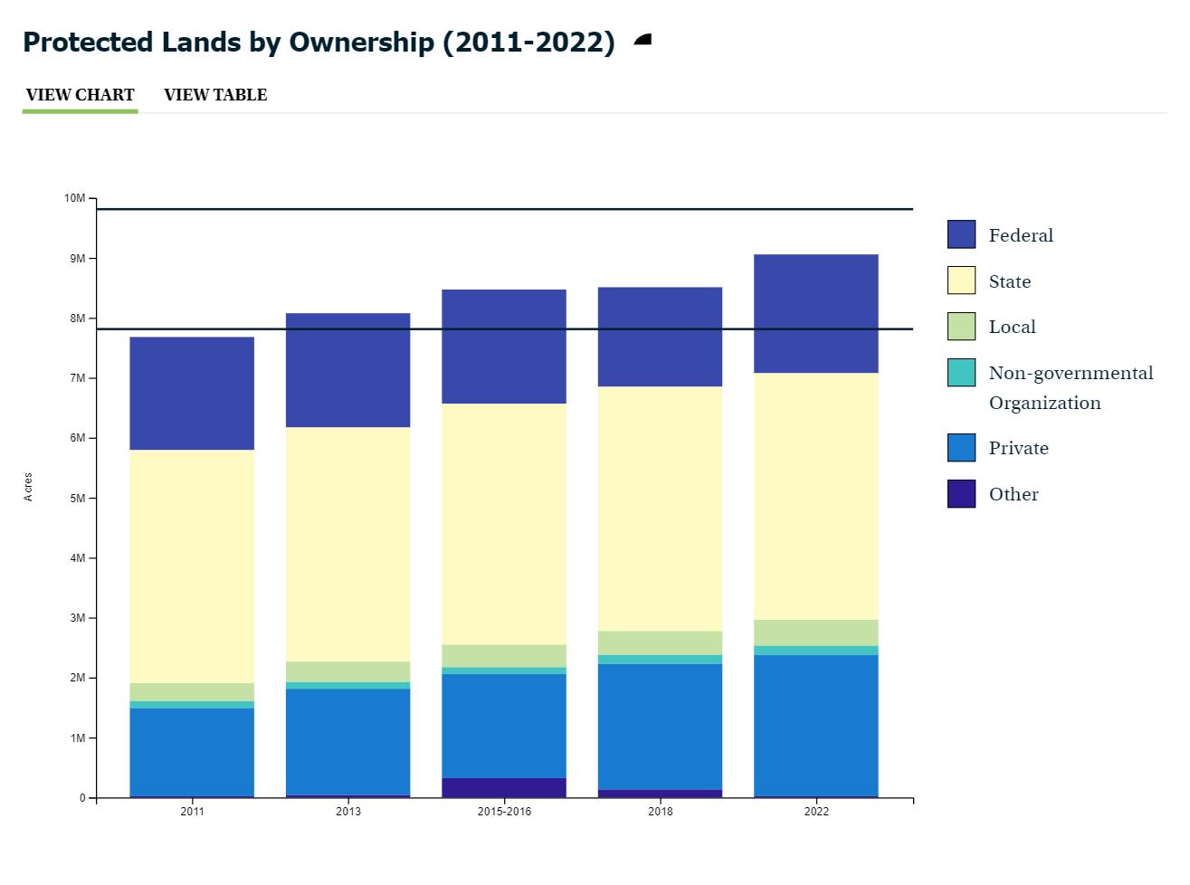
The Conservancy’s leadership, working with the CCP and its partners, has successfully expanded conserved lands across the Chesapeake watershed. From 2010 through 2024, about 90% of the goal was reached for conserving 2M acres by 2025. Based on earlier data, contributions to protect lands are from a range of organizations: state, federal, local agencies, NGO, along with considerable contributions from private donors (see fig 1.1). Overall, about 126,000 acres have been conserved per year since 2011. However, to reach the 30x30 goal, the rate of land conservation would have to be more than tripled to 415,000 acres a year (see link below). Additionally, the 30x 30 goal has an uncertain future because of changing priorities of the federal government.
https://chescon.maps.arcgis.com/apps/dashboards/5979e716b18144c989b884bb437dffd2
In December 2025, the Chesapeake Bay Program signed a new Chesapeake Watershed Agreement for goals and outcomes through 2040. The new CBP agreement includes an updated protected lands outcome:
By 2040, permanently protect at least an additional 2 million acres of land above the 2025 baseline of 9.3 million acres. The 2 million acres will include specific targets for: riparian forests; wetlands (including migration corridors); natural areas supporting healthy streams; agricultural lands; tribal homelands; and urban and community greenspace.
The CBP has shared they will have a support role in land conservation and depend on partners for acquiring and protecting lands. Therefore, the Conservancy should continue its leadership role in land protection, working with partners and donors, to help the CBP meet or exceed 2M acres by 2024.
Figure 1.1: Number of acres protected by different agencies and organizations between 2011 and 2022 (from the Chesapeake Bay Program).
The Task Force further recommends the Conservancy consider supporting other outcomes of the new Chesapeake Watershed agreement. The new Agreement has four (4) major goals:
● THRIVING HABITAT, FISHERIES AND WILDLIFE GOAL: Protect, restore and sustain fisheries and wildlife, as well as the network of land and water habitats they depend on, to promote a balanced and resilient ecosystem and support local economies and recreational opportunities.
● CLEAN WATER GOAL: Reduce pollutants entering the Bay and its rivers to achieve the water quality necessary to support aquatic life, wildlife and protect human health.
● HEALTHY LANDSCAPES GOAL: Conserve, protect, restore and enhance landscapes of ecological, economic, recreational and cultural value to improve water quality, provide habitat for wildlife and increase resilience.
● ENGAGED COMMUNITIES GOAL: Engage and grow a community of local stewards and leaders through education, recreation and professional opportunities to ensure the long-term success of restoration and conservation efforts.
Each of these goals have associated measurable outcomes, and the entire agreement can be viewed here: https://www.chesapeakebay.net/files/documents/CBWA-2025-IV-Final-Facing.pdf
The Conservancy can also support the CBP Healthy Forests and Trees Outcomes that are under the Healthy Landscapes Goal:
● Conserve tree canopy within communities by reducing the rate of loss of existing canopy, and planting and maintaining 45,000 acres of trees by 2040 to achieve a net gain in canopy over the long-term.
● Achieve a net gain in forests over the long-term by reducing the rate of forest conversion to other land uses by 33%, permanently protecting a total of 8.6 million acres of forested land (nine million acres by 2040), and planting, maintaining and managing 202,000 acres of new forests by 2040.
Conservancy efforts to protect HVLs would also contribute to the CBP Clean Water Goal, since protecting lands will prevent nutrients, sediment, and toxic contaminants from entering streams and rivers and promote healthy waters for living resources and human health.
Our efforts would also contribute to the CBP Thriving Habitat Goal and its outcome to restore stream health. The Conservancy has partnered with the commonwealth of PA to restore streams so they can support fisheries and be enjoyed by local communities. We are expanding efforts to MD under our Tributary Strategy Initiative. As the Conservancy works with partners to restore streams, we will also focus on protecting the supporting watersheds to maintain the restored conditions of these streams.
Finally, under the CBP Engaged Communities Goal, the Public Access Outcome has a relation to our criteria to provide community benefits.
● By 2040, add at least 100 new sites providing access to natural lands and waters with a strong emphasis on providing opportunities for recreation where feasible.
Recommendation: Establish criteria to guide land protection: High Value Lands.
The Task Force researched the land conservation priorities for different organizations working in the Chesapeake watershed. These organizations had varied conservation priorities, ranging from an emphasis on ecological benefits, places with cultural and scenic value, and others with public access and recreational potential. To develop our own unique priorities, the Conservancy considered the following conservation planning principles:
● Ecological including water quality, biodiversity, and landscape fragmentation
● Cultural, heritage, and scenic including historic places, native American and African heritage, and viewsheds.
● Community benefits including public access and low-impact recreation.
● Climate resiliency including flood protection and carbon sequestration.
● Threats to HVLs due to development and/or climate effects.
● Management and feasibility: costs of lands and program and donor opportunities to acquire lands.
The Task Force recommends the Conservancy’s overall priority for land protection is to focus on HVLs. The Task Force evaluated these conservation planning principles, and assessed the
priorities of other organizations, to prioritize key criteria for HVLs (fig 1.2) The three criteria are: (1) protect healthy waters, (2) promote community benefits, (3) enhance connectivity, and the areas where these 3 criteria overlap would be potential HVLs. These areas would be further defined based on their vulnerability to development and/or the effects of climate change. The HVLs would provide the Conservancy with a unique niche for protecting lands across the Chesapeake Bay watershed, with an emphasis on the quality of the lands protected, not just the amount. The criteria and vulnerability assessment are defined in the following paragraphs. The process to map, prioritize, and approve HVLs to pursue is presented in section 3.
Figure 1.2: Flow chart of how HVLs are defined.
Criteria for defining HVLs.
The three criteria the Task Force recommends for defining HVLs are summarized in the table below:
Criteria Benefits
Protect healthy waters
Community Benefits
Healthy waters provide recreation for people and support water-dependent wildlife.
Approaches
To protect healthy waters, the lands in surrounding watersheds need to limit contributions of nutrients, sediment, and toxic contaminants.
Enhance Connectivity
People in local communities have safe, affordable, and meaningful opportunities to enjoy and benefit from outdoor recreation and natural spaces, including rivers, trails, parks, and waterfronts.
Expand corridors of lands protecting healthy waters and community benefits.
Local communities will increase their stewardship of these places and support the mission of the Conservancy
Work with partners to fill gaps that cross jurisdictional boundaries given the Conservancy’s watershed-wide role
Criteria 1: Protect Healthy Waters
The streams, rivers, and wetlands across the Chesapeake watershed, which provide recreation for people and support water-dependent wildlife, need to be protected. Clean water is a unifying goal for the CBP and many members of the CCP. Its prioritization by the Conservancy provides a foundation to engage with federal, state, and local agencies and organizations on land protection efforts.
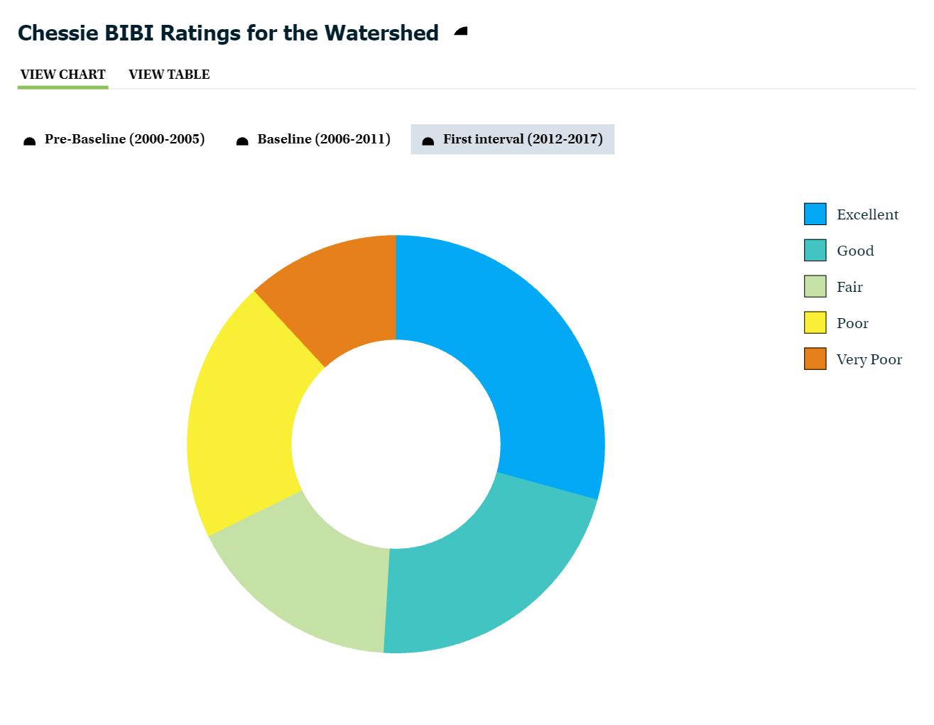
The Conservancy will use the aquatic health of streams to define healthy waters, which is based on the index of biological integrity (IBI) developed by the Chesapeake Bay Program (see chart fig 1.3). For the IBI, emphasis will be on waters having excellent or good quality, which represent about half of the streams in the watershed. In the future, the Conservancy may also use the Clean Water Act Impaired Waters which identifies degraded streams. However, at this time each state assesses impaired waters differently, so the list cannot be applied across the entire watershed.
Figure 1.3: The criteria for healthy waters are based on data from the Chesapeake Bay Program. Streams and contributing watersheds are ranked from excellent to very poor The Conservancy criteria will focus on protecting streams in excellent and good condition, or those that have been restored.
Healthy waters are influenced by the conditions of the surrounding lands, so protection efforts need to focus on the contributing watersheds. To protect healthy waters, the lands in surrounding watersheds need to limit contributions of nutrients, sediment, and toxic contaminants. The Conservancy is developing an innovative approach to assess the potential impacts on healthy waters based on the estimated amount of nutrient and sediment loading that may be prevented from adjacent lands if they were not developed. This approach provides a framework consistent with that being used by the CBP and their Chesapeake Assessment Scenario Tool (CAST) and is further explained in Section 3.
The Conservancy also has an opportunity to protect waters that have been restored. The Conservancy Tributary Initiative uses a data-driven approach to work with partners to improve local creeks and streams across the Chesapeake watershed. The initial effort is focused on working with partners in PA to restore streams and remove them (“delist”) from the impaired waters list. Where streams have been restored there are opportunities to protect HVLs in surrounding watersheds to maintain the health of the restored streams. More information on the Tributary Initiative is available: https://www.chesapeakeconservancy.org/what-we-do/restorestreams
Criteria 2: Promote Community Benefits.
The second criteria focuses on ensuring that people in local communities have safe, affordable, and meaningful opportunities to enjoy and benefit from outdoor recreation and natural spaces, including rivers, trails, parks, and waterfronts. Community benefits include increasing public access and recreational opportunities through HVLs. By fostering planning and protection of the natural and cultural resources of HVLs, local communities will increase their stewardship of these places and support the mission of the Conservancy. The Conservancy will use a measure of greenspace per person to help assess benefits to communities. More greenspace can provide more opportunities for recreation and people enjoying nature. Mapping of the criteria is explained in section 3.
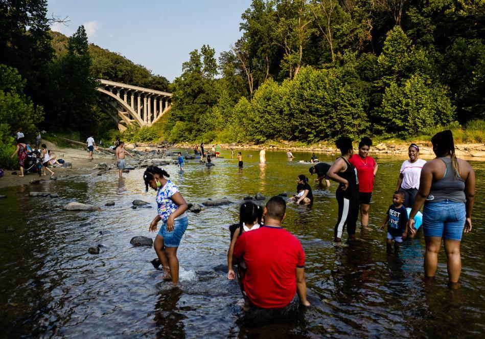
High-value lands will protect healthy waters and provide benefits to local communities and biota that depend on streams. (Photo courtesy of the Chesapeake Bay Program)
Criteria 3: Enhance connectivity.
The Conservancy will prioritize lands that enhance the connectivity of healthy waters and their associated watersheds. These healthy waters are usually important for recreational fisheries and outdoor opportunities for local communities. Additionally, many conservation efforts are focused on individual states or counties because the funding programs often follow jurisdictional boundaries. The Conservancy has a unique opportunity to work with partners to fill gaps that cross jurisdictional boundaries given our watershed-wide role.
Where the three criteria overlap would define potential HVLs, illustrated in a conceptual diagram of a watershed (fig S.1 is shown again). The criteria for healthy waters would be examined to determine if streams are healthy (shown in blue) or degraded (shown in red). HVLs (greenyellow icons) are ideally located where there is overlap (upper right of diagram) of healthy streams, with community benefits (shown as the people icon) and enhanced connectively (protected lands icon). HVLs could also be located where streams have been restored (orange)
to maintain their quality and provide benefits to local communities (bottom left of diagram) Areas that only meet one criteria would not be considered HVLs. The HVLs would be further defined by their vulnerability to development and climate effects (not shown on diagram). More details on identifying and prioritizing HVLs are provided in section 3.
Figure S.1: Conceptual diagram of criteria for high-value lands (HVLs). HVLs are where multiple criteria overlap.
Assess vulnerable lands.
The potential HVLs would next be assessed to consider vulnerability to development and/or the effects of climate change. Development is occurring to meet housing, energy, and transportation needs of the growing population in the watershed. Losing these lands will cause an increase in nutrients, sediment, and toxic contaminants to streams and rivers Additionally, climate impacts are raising temperatures in streams making them less healthy for fisheries. The Conservancy wants to protect HVLs before they are lost to development and/or affected by climate change. More information on how vulnerability will be assessed is in section 3.
Recommendation: Ensure alignment between the Conservancy Land Protection Strategy and Giftlands Program.
The Task Force recommends that the HVL criteria also be applied to evaluate lands brought to the Conservancy through our Giftlands program. The Conservancy established its Giftlands Program in 2020 and prepared an operating plan. According to the plan, the purpose of the program is to develop a scalable land donation strategy that (1) supports the Conservancy’s overall mission and 30x30 targets, (2) generates significant unrestricted financial resources, and (3) does so while minimizing organizational risk and staff capacity to increase return on investment. The program was designed to leverage our precision conservation expertise, which was developed through the Conservation Innovation Center (CIC) and strategic relationships throughout the watershed. The plan stated that the Conservancy will actively solicit gifts of real estate through targeted marketing and by leveraging our conservation network and strategic partners, and that the Giftlands program will accept two types of real estate gifts:
● Trade lands. Donated lands or properties that have limited or no conservation value that can be sold through a third-party broker to generate unrestricted revenue.
● Conserve lands. Donated lands that can be permanently protected with conservation easements or other means in collaboration with Chesapeake Conservation Partnership members and other strategic partners.
The Giftlands Program criteria for conserving lands should be updated to align with the criteria for HVLs in the Conservancy’s Land Protection Strategy. The Giftlands program uses a “Conservation Scorecard” to determine if a piece of land should be considered for long-term protection, which is focused in Maryland, Virginia, and Delaware. These criteria should be revised so the Conservancy has an aligned set of criteria for what we consider HVLs. The criteria and operating steps for “trade lands” in the Giftlands Program can stay the same.
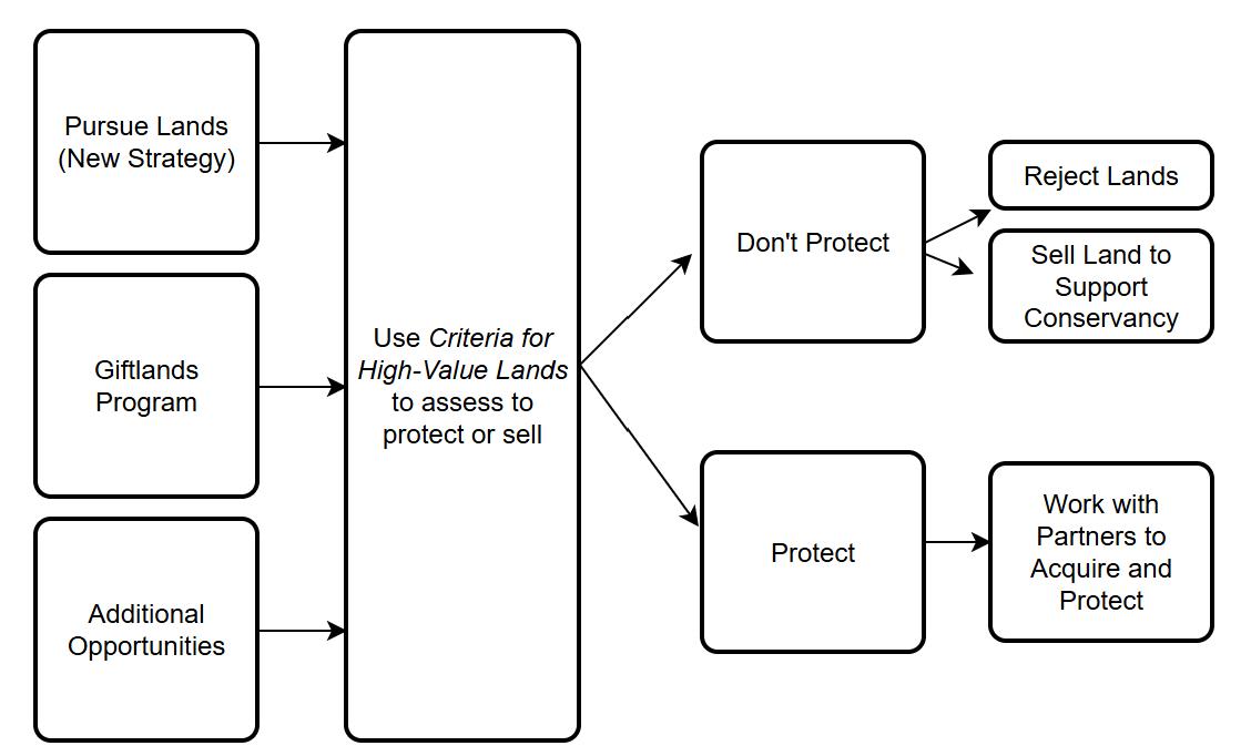
The proposed decision framework for the Conservancy to protect or sell Giftlands parcels and other opportunities brought to the organization is shown in Figure 1.4. All lands being considered for protection would be assessed using the new criteria for HVLs. If a parcel of land meets the criteria for HVLs, the Conservancy should work with partners to acquire and protect it. However, if a parcel of land doesn’t meet the criteria, the parcel would be considered a “trade land” and follow the established guidance for the Giftlands Program.
Figure 1.4: Decision framework for the Conservancy to protect lands, sell them to support our mission, or reject the opportunity, and its relation to Giftlands Program.
Recommendation: Increase the Conservancy’s land protection profile by seeking Land Trust Accreditation.
In August 2019, the Conservancy’s Board of Directors passed a resolution approving the adoption of the Land Trust Alliance’s Standards & Practices, a series of best practices for land conservation organizations regarding the ethical and technical principles central to all real estate transactions undertaken by the organization. The Task Force recommends seeking Land Trust Commission accreditation to raise the profile of the Conservancy’s land protection efforts. We realize the Conservancy does not wish to hold lands for long-term protection, but accreditation would enhance our ability to interact with donors, landowners, and public agencies as they develop more sophisticated approaches for assessing land protection opportunities.
The following are just some of the reasons why such an effort may be timely:
● Increasingly we see foundations and other conservation funders using accreditation as one screen to determine appropriate grantees.
● States are using accreditation to determine whether an organization is a qualified holder (even temporarily) of gifts of land or easements from donors or will qualify as a done for state conservation tax credits.
● As a member in good standing of the conservation community, there is an expectation that the Conservancy will meet the same standards as some 478 accredited land trusts
in 46 U.S. states and territories (as of April 2025), many of whom will be the partner organizations with whom we want to build relationships.
● There are also financial savings (lowered insurance costs) that the organization could realize as an accredited land trust.
● And finally, the process of securing accreditation will enable the organization to conduct a self-evaluation of its own conservation practices to evaluate its organizational health.
The LTAC Application process for land trust accreditation is based on a rolling application process. The Land Protection Director would shepherd the Conservancy application for accreditation. Application slots for first-time accreditation are filled via lottery. Applicants must submit an $850 registration fee with a pre-application registration lottery form. The LTAC Commission then reviews and formally accepts (or declines) the pre-application (based on the volume of applications submitted and the capacity of the LTAC to manage the number of applications). Accepted applicants receive verification of approval/acceptance for formal application ~2 months prior to the formal application due date. Once the formal application is submitted, the review process typically takes from 10 months to a year to complete and upon satisfactory completion the applicant is awarded accreditation for a five-year term (which thereafter will require an accreditation renewal process.)
Upon submission of the formal application for accreditation, the applicant must pay an ‘Application Base Fee for Five-Year Term Accreditation.’ The fee is all inclusive. It covers the application review, outreach calls, any consultations over the accredited term with Commission staff, and all other accreditation actions and activities. The amount of the fee is based on a sliding scale reflective of the applicant’s total organizational expenses as reported on the “Total Expenses” line from page 1 of the most recent Form 990 or Form 990-EZ. There is also a discount on the fee depending on whether the organization is a current member of the Land Trust Alliance in good standing. By way of example, for 2026, for an organization with organizational expenses of between $2.5 million to $5 million and which is a member of LTA, the fee would be $15,230; and organization which is not a member of LTA would pay a fee of $38,075.
For additional information on Land Trust Acceleration see: https://www.landtrustaccreditation.org/storage/downloads/2021/benefitsofaccreditation_2021.pdf
Section 2 - How: Organizational Changes Needed to Implement the Strategy
This section of the Strategy focuses on the organizational approaches the Conservancy should consider for achieving the land protection goals and criteria discussed in section 1. The recommendations discussed in this section include:
● Establish a team dedicated to land protection.
● Create two full-time positions to lead efforts: a Land Protection Director and a Land Transaction Specialist.
● Supplement the team with existing staff to ensure collaboration across the Conservancy.
● Develop a sustainable funding plan for the land protection efforts.
Recommendation: Establish a Conservancy team dedicated to land protection.
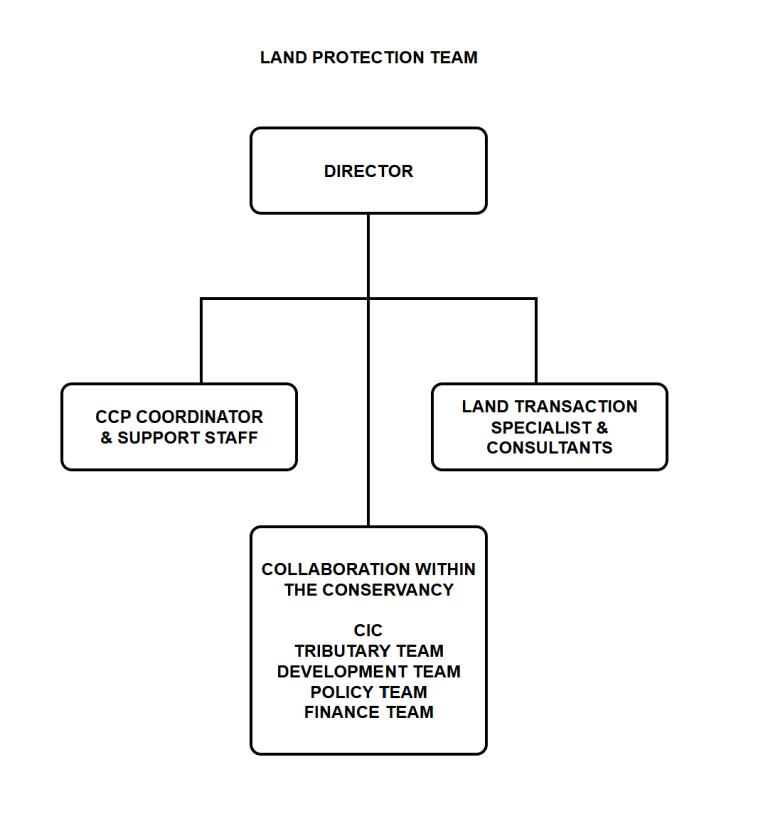
The team would consist of a Land Protection Director, a Land Transaction Specialist, the CCP Director and staff support from the CIC, and collaboration with the Conservancy’s Tributary, Development, and Finance teams, and Conservancy leadership (see fig 2.1). The Land Protection team would most likely be placed under the programs portion of the Conservancy, but the current organizational chart is being updated. The Conservancy ad-hoc group that currently makes land protection decisions would be merged into the new Land Protection team.
The roles of the team members are discussed in the next two recommendations. The primary functions of the Land Protection team are to carry out the 5-step process (figure S 2) presented in the summary section, and include:
(1) Identify a portfolio of potential priority watersheds and HVLs. The Land Protection team, collaborating with the CIC, would use current and new data and technologies to identify a portfolio of HVLs across the Chesapeake watershed that protect healthy waters, promote community benefits, and enhance connectivity. These data will be applied using the Conservancy Decision Tool developed by the CIC (explained in more detail in section 3). The team would identify 5-10 priority watersheds to focus efforts, and there would be multiple HVLs within each watershed. The team would also interact with the Tributary team to consider streams that would benefit from protection or could be restored within HVLs.
(2) Engage partners on their interest in HVLs. The initial list of priority watersheds and associated HVLs will be shared with partners and donors to assess their interest in pursuing the lands. The team will interact with the CCP and individual members to gauge their interest in long-term protection. The team will also work with the Development team, who will interact with existing donors and cultivate new ones to fund land protection efforts.
(3) Revise and prioritize the HVLs to pursue. The team will present and discuss the portfolio and cost-benefit analysis with Conservancy leadership for their input to prioritize the HVLs to pursue. The team would assess the benefits of how proposed HVLs meet the Conservancy’s mission, align with partner programs for long-term protection, have political support, and the willingness of landowners to sell properties. The cost would be assessed by working with the Conservancy’s Land Transaction Specialist and
consultants, and by gathering information from landowners. The team would determine the price of lands and work with leadership to determine the staff time needed to pursue the lands, acquire the lands, and find a willing partner for long-term protection. Finally, the Land Protection Director will work with the Finance team and Conservancy Leadership on interim funding needed until the lands are transferred to partners for longterm protection.
(4) (4) Interact with Conservancy Leadership and the Board for approval to acquire HVLs. As individual parcels of lands become available, the Land Protection Director and the Conservancy CEO bring them forward to the Board for approval. The Task Force suggests that different financial thresholds be used for approval (see section 3 for more details).
(5) Pursue acquisition and transfer of HVLs. The team would handle the negotiations for acquiring and transferring the lands by working with partners, donors, and sellers for long-term protection. The team would keep the Conservancy CEO and Board updated.
More information on carrying out each step is provided in section 3.
Figure 2.1 Proposed Land Protection team organization chart
Recommendation: Hire a Land Protection Director and a Land Transaction Specialist.
The Task Force recommends the Conservancy add two positions to establish the Land Protection team to address these responsibilities.
Land Protection Director: This Director provides leadership and coordination to oversee the land protection efforts for the Conservancy across the Chesapeake watershed. The Director also undertakes the necessary steps in land acquisition and land protection projects for the Conservancy, including without limitation, securing appraisals and title work, negotiating transactions and securing funding from public and private sources. The Director will oversee a team that works across several groups within the Conservancy, including the Conservation Innovation Center, Development team, and Tributary team, to identify and prioritize HVLs. The Director will work with partners to identify the most promising programs and funding opportunities for lands and conduct a cost-benefit analysis to further prioritize HVLs. The Director will interact with Conservancy leadership and the Board to finalize the HVLs to pursue and the associated funding needs.
Land Transaction Specialist: A Land Transaction Specialist is also recommended to be hired as the program grows. The Specialist has expertise to help with the valuation, cost/benefit analysis and due diligence (e.g appraisals, environmental hazard reports, title searches, etc.) required for the protection or acquisition of potential HVLs, as well as the handling of the transaction of those lands the Conservancy decides to pursue. The Conservancy could continue to use consultants (or increase their time), who must know the local requirements of where the land is located, for this expertise.
Recommendation: Supplement the Land Protection team with existing staff to ensure collaboration across the Conservancy.
Several existing groups within the Conservancy would interact with the Land Protection team and include (see figure 2.1):
● CIC Staff: interacts with the Land Protection Director to conduct the assessment of potential HVLs and creates the portfolio using CIC tools. The CIC involvement would include a senior analyst, web application developer, and the CIC Associate Director to manage the work. In year 1, 6 months of staff time will be needed to update the needed current CIC tool and data sets and conduct the initial analysis of HVLs. In year 2, the CIC will build a new tool that can identify HVLs ae the parcel scale. In future years, about three months of staff time will be needed each year. (see the next recommendation and section 3 for more details)
● Tributary Team: provides input on streams to be protected and those that could be restored for future protection.
● Chesapeake Conservation Partnership Coordinator: interacts with CCP and individual members on their interest to acquire and protect HVLs.
● Policy Team: Works with agencies to consider new policies to protect HVLs.
● Development Team: analyzes information and makes contacts to assess funding and donors’ opportunities to acquire HVLs.
● Finance Team: provides oversight of funds available to acquire lands until transferred to another organization for long-term protection.
Recommendation: Develop a sustainable funding plan to support the Land Protection team.
Funding will be needed to support the Conservancy’s Land Protection team once it is implemented. Table 2.1 provides the estimated new costs and what the Conservancy already spends on land protection activities.
The estimates for new costs include hiring the Land Protection Director and Land Transaction Specialist and additional CIC support. Year 1 would focus on (1) hiring the land protection director, (2) having the CIC to update the current land decision tool needed to produce the initial portfolio of HVLs, and (3) collaborating with partners and across the Conservancy to prioritize the lands. Funding for the Land Transaction Specialist begins in year 2 as more lands are pursued (but could be carried out by increasing funds for existing consultants). Year 2 also includes one-time funding for the CIC to develop a parcel-level decision tool (explained in section 3). The current CIC land protection tool cannot identify individual HVLs parcels, which is needed for more effective identification and ranking. In year two the CIC will create a new decision tool to identify individual HVLs. Year 2 cost is estimated to be $175,000 which includes a technical lead, senior data analyst, GIS web developer, and the Deputy Director leading the development of the tool and providing support and analysis to apply it. This cost also includes technical costs including server and cloud-based services for data processing and storage in addition to general data management, data security, and hosting of the web application. In future years about three months’ staff time will be needed each year for analysis and support, costing about $50,000.
The estimate of what the Conservancy currently spends on land protection efforts is close to $200,000. While land protection efforts are not currently tracked in the Conservancy's budget, the Finance team provided a snapshot of recent annual spending on land protection activities:
● Estimate of senior staff time on land protection: $30,000
● Consultant invoices related to land protection: $51,000
● Additional costs related to land management activities (taxes, consulting, carrying costs, fees): $113,000
● Total estimated costs: $194,000.
The costs of supporting and co-leading the CCP, which is an important coalition for land protection, are not reflected in this estimate. Those funds are provided by the NPS and USFWS.
The estimated total costs for implementing the Land Protection team would be about $419,000 in year one, increase to almost $609,000 in year 2, and afterwards would be about 484,000 per year (last line in table 2.1). These costs include hiring new staff, collaborating with existing staff and supporting consultants, expenses associated with acquiring lands, and making sure they are transferred to another entity for long-term protection.
Table 2.1: Estimates of costs for the Conservancy's Land Protection team Position
Comments
New Costs
Land Protection Director
(full time)
Land Transaction Specialist Use existing consultants
CIC Support
Most important hire
May be able to use (or increase) time of existing consultants instead of new position
Year 1 to update tools and data sets. Year 2 build new tool. Apply tools in year 3 and beyond Total of new costs
Estimates of current spending on land protection efforts
Input from Senior Staff including Tributary and Finance teams and CCP coordinator
Consultant costs for land protection
Additional costs (legal fees, taxes, carrying costs)
Totals of existing costs
CCP liaison costs are paid by NPS and USFWS, so they are not reflected.
These may be low and could change depending on Land Transaction Specialist being hired
Cover with existing salary
Does not account for inflation Total estimated
for Land Protection team
Annual long-term costs of about 500K per year. Does not account for inflation
Typically, in other conservation organizations, the land protection function is a key or core component of the operations of the organization. It is therefore often funded out of general operating support for the organization, which would be unrestricted funds for the Conservancy.
The Task Force recommends the Land Protection team develop a plan for the funding needed to support the Conservancy’s land protection efforts. Potential ideas to pursue include:
● Undertake capital campaigns, in collaboration with the Development team, to raise the funding needed to endow the new Land Protection Director position or the funds needed to support (or supplement) the land protection function.
● Proceeds from selected land sales through the Giftlands program could also be used to help fund or endow the Land Protection Director position.
● Develop key performance indicators (KPIs) to show agencies, organizations, and donors their return on investing in land protection with the Conservancy. The KPIs would match HVLs, resource and watershed protection goals, with reasonable goals on converting lands to conservation in an annual up to 5-year plan, so that the Conservancy can make a strong business argument to donors, grantors, and other funding sources of the value and need for funding. KPIs can also be a reporting mechanism for the annual reports, which can be used to develop interest from landowners who might be incentivized to participate by performance, transparency, and a business-driven model that shows success.
The funding could come from fees on the acquisition and transfer of HVLs. However, care should be taken to ensure that using the sale of land as a source to fund the land protection efforts does not create unintentional consequences (e.g. pressure to increase the number of transactions to realize monetary goals).
Section 3 - Where: Science-based Approaches to Focus Land Protection
This section describes the steps and decision framework for identifying, prioritizing, and approving the protection of High-Value Lands (HVLs) for the Conservancy. The recommendations for this section are:
● Use a science-based approach to identify and inform priorities for HVLs.
● Engage partners and donors about their interest to acquire and protect HVLs.
● Prioritize and finalize the HVLs to pursue.
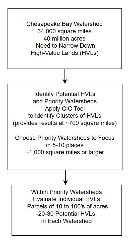
Deciding on which HVLs to pursue is a difficult challenge because of the vast size of the Chesapeake watershed. The different scales that need to be considered to identify HVLs are shown in figure 3.1 and include:
• The Chesapeake watershed is 64,000 square miles, which contains about 40 million acres of land, so we need to narrow down where to focus.
• The Conservancy will identify clusters of potential HVLs to select priority watersheds. The initial large-scale HVLs are sub watersheds that average about 700 square miles (they are based on the output of the CIC decision tool). Priority watersheds would be selected based on evaluation of clusters of the large-scale HVLs.
• HVLs parcels would be identified within priority watersheds. In most instances, the final HVLs parcel have a single landowner and range in size from 10s to 100s of acres. So additional analysis is needed within priority watersheds to evaluate individual HVLs.
Figure 3.1: Scales that need to be considered for identifying high-value lands.
The Conservancy will follow a five-step process to identify, prioritize and pursue the protection of HVLs (figure S.2 is shown again below). The process will allow the Conservancy to initially identify a set of potential HLVs and interact with organizations and landowners to prioritize them to a manageable number to pursue.
Figure S 2: Steps to identify and prioritize HVLs for the Conservancy to protect
The 5 steps of the process are:
● Step 1: Develop a portfolio of potential HVLs and priority watersheds. The criteria for HVLs were described in section 1, and include (1) protect healthy waters, (2) promote community benefits, and (3) enhance connectivity. The vulnerability of these potential HVLs to development and/or the effects of climate change is also assessed during this step. There will be multiple large-scale HVLs identified across the Chesapeake watershed. To help focus efforts, the Conservancy will identify 5-10 priority watersheds, where there are clusters of the large-scale HVLs. Within each priority watershed, there will be a portfolio of 20-30 individual HVL parcels to further assess land protection efforts (see recommendation 1 for more details).
● Step 2: Engage partners and donors. This step will engage organizations and donors to assess which priority watersheds, and the potential HVLs within them, they have an interest in working with the Conservancy (see recommendation 2 for more details).
● Step 3: Review and prioritize. The Conservancy will evaluate the costs and benefits of individual HVLs to prioritize the ones to pursue. The results from steps 1 and 2 will be used by the Land Protection team and Conservancy Leadership to decide in which priority watersheds to focus their efforts. The number of priority watersheds will depend on the staff capacity, because each will need dedicated staff to evaluate the associated 20-30 HVLs parcels and contact owners about their willingness for long-term protection (see recommendation 3 for more details).
● Step 4: Approve deals to acquire HVLs lands. The Conservancy CEO will bring deals for individual HVLs to the Board for approval (or ask for more information, or rejection). The Task Force suggests that different financial thresholds be used for approval (see recommendation 3 for more details).
● Step 5: Pursue, acquire, and transfer HVLs. After the deal is approved, the Land Protection team works with partner organization (or donor) and the landowner to acquire and protect individual HVLs (see recommendations 3 for more details)
The steps are further explained in the following recommendations.
Recommendation: Use a science-based approach to identity and inform priorities for HVLs.
Potentially there are thousands of HVLs across the Chesapeake watershed, but the Conservancy only has the capacity to work on a limited number. The science-based approach, using current and new data and technologies, will allow the Conservancy to strategically identify and narrow down the list of potential HVLs to pursue. The CIC land protection decision tool will be essential for the science-based approach to help identify HVLs. The tool was originally developed in 2023-24 to help the Conservancy consider and prioritize opportunities for land protection.
The CIC tool is being updated to include data for the HVLs criteria and currently provides results at the 8-digit Hydrologic Unit Code (HUC), which averages about 700 square miles. While this scale (700 square miles) can be useful for identifying large-scale clusters of HVLs and priority watersheds, it is not adequate to identify individual parcels of HVLs. To address this limitation of the current CIC tool, the Task Force recommends a two-phase approach to mapping:
• Phase One: The CIC tool will be updated with available data to map clusters of large-scale HVLs that can be grouped into priority watersheds The Conservancy will need to do additional evaluation to identify individual HVL parcels in the priority watersheds. The CIC tool could also be used to potentially assess lands that are brought to the Conservancy through the Giftlands Program or other donors.
• Phase Two: Create a parcel-level decision support framework using innovative approaches for a more direct analysis and ranking of HVLs. An initial improvement will strive to be more consistent with the prioritization efforts by the CBP to restore and protect water quality. The Conservancy is considering a modeling approach to estimate at a given parcel the amount of nutrients and sediment that would be prevented from entering waterways if that parcel were protected instead of being developed. This analysis leverages the Conservancy’s hyper-resolution hydrography and high-resolution land cover data to guide precision parcel prioritization. More details are provided later in this recommendation.
Phase One
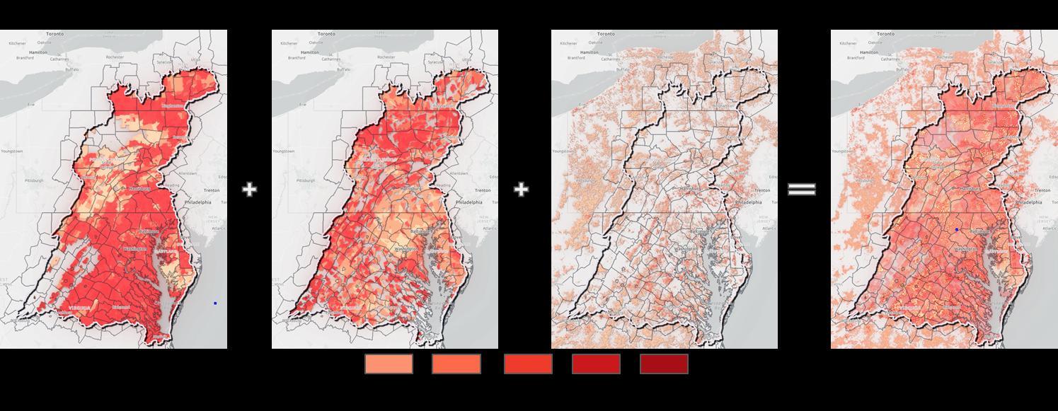
The CIC tool will be used to map criteria for HVLs and assess their vulnerability across the Chesapeake watershed, using a stepwise approach (figure 3.1). The CIC tool would be applied to the entire Chesapeake watershed to identify large-scale HVLs (first box in fig 3.1) The CIC
tool displays results of the large-scale HVLs of about 700 square miles There will be multiple possibilities, so the Conservancy will have to further examine where clusters of HVLs occur to identify 5-10 priority watersheds to focus our efforts (second box in figure 3.1). In addition to using results from the CIC tool, the Conservancy would use their understanding of where partners have a mutual interest or there are donor opportunities to help select the 5-10 priority watersheds. The size of the priority watersheds could be about 1000 square miles or larger depending on the number of large-scale HVLs that are grouped together. Since the CIC mapping tool cannot identify HVLs at the parcel level, the Conservancy will primarily rely on interacting with local organizations and donors to identify the 20-30 individual HVLs within these priority watersheds to pursue (bottom box in figure 3.1).
During Phase 2 the Conservancy will develop an approach to estimate the potential amount of nutrients and sediment a parcel could contribute to local waterways (i.e. ‘loading’) if it is not protected. Using a measure of amounts of nutrients that are prevented from entering a stream from a parcel of land is consistent with approaches being developed by the CBP to prioritize land protection and their overall approach to restore water quality in the Bay and its watershed.
At every parcel, the Conservancy would estimate the current contribution of nitrogen, phosphorous, and sediment to surrounding waterways using the same framework and coefficients as the Chesapeake Assessment Scenario Tool (CAST) model. CAST is used by the Bay Program to estimate the effect of proposed land use and best management practice plans on water quality and assigns different loading rates to different land covers. Our analysis would use the Conservancy’s high-resolution land-cover data and CAST coefficients to calculate the total current nutrient and sediment loading for any given parcel. Then, we calculate the load for each parcel if it were to be converted to the most likely alternative land use in the region (e.g., cropland, residential, etc.). The analysis would also use the Conservancy’s hyper-resolution hydrography data by identifying flow paths from each parcel to the nearest stream so that we can adjust loading based on the land cover in between a parcel and the nearest stream. This framework is being piloted and evaluated in the Dragon Run watershed (Figure 3.2) and can ultimately be used to score every parcel in the entire Chesapeake watershed.
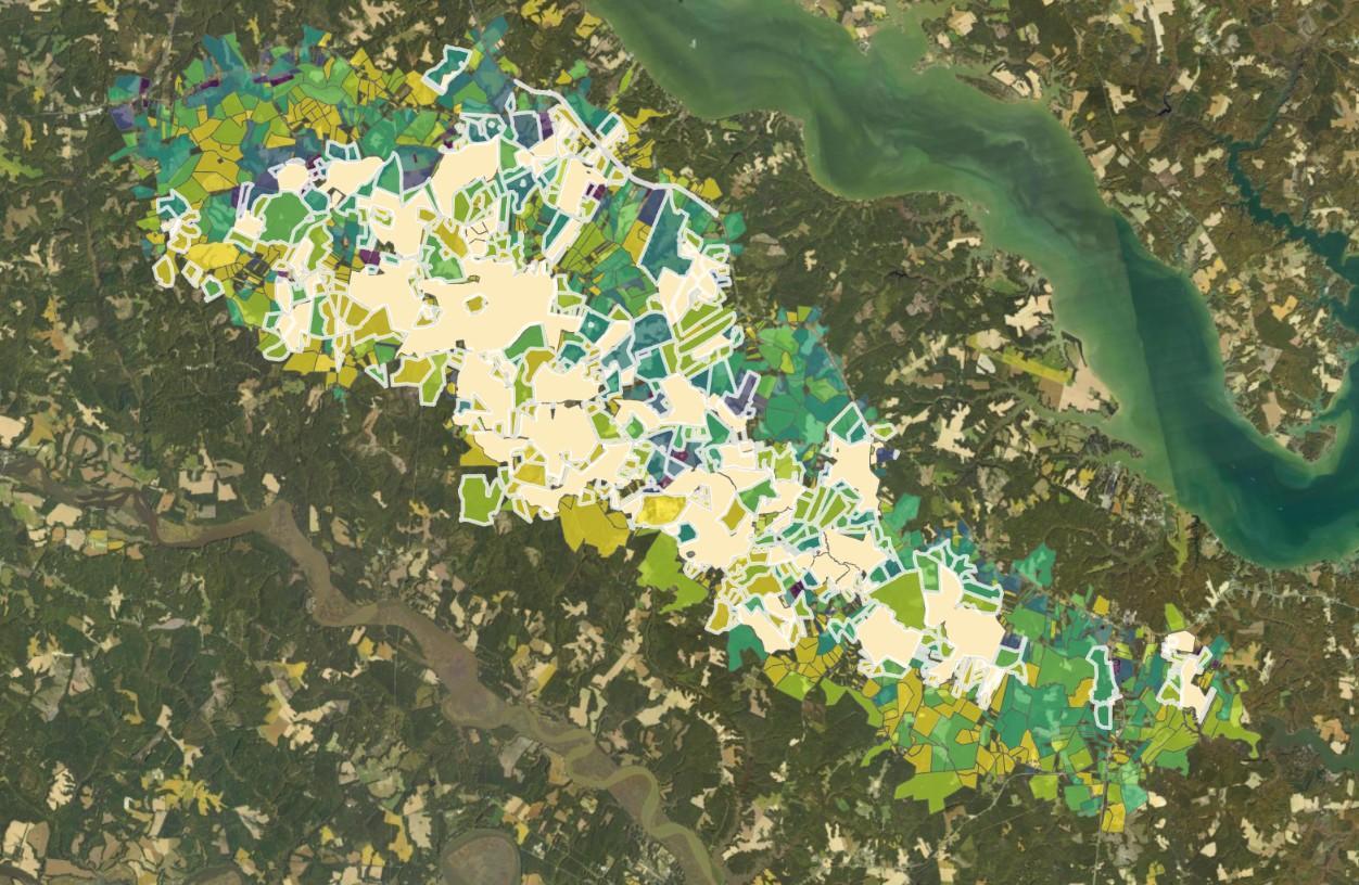
Figure 3.2: Example of approach to rank parcels based on preventing nutrients and sediment from entering streams if they are protected.
During Phase 1, the Land Protection team will have to work closely with local organizations to identify potential HVLs in these small watersheds (read more in the next recommendation). To address these limitations due to scale, the Conservancy will undertake Phase 2 of the mapping effort so decisions can be made more directly at the parcel level.
Considerations for prioritizing HVLs
Table 3.1 lists data in the CIC tool and suggested ways to prioritize the mapping results. Stream health would be used for healthy waters (defined in section 1). The available data set shows stream health and their contributing watersheds, which are ranked between 1 (very poor) to 5 (excellent). Highest priority for HVLs would be given for excellent (5) or good conditions (4)
The mapping of community benefits is based on a measure of the amount of greenspace per person. The amount of greenspace is based on forests and wetlands in a census block. The amount of people in census blocks is also documented. The values were calculated for the Chesapeake Conservation Partnership Equity Mapping Tool in 2022. The decision support tool assigns higher priority to areas (census blocks) where there is more greenspace per capita (per person). The CIC tool uses a range from zero to 5. A ranging of “zero” represents >200 acres of greenspace without any people, so very few communities benefit. Higher ratings mean a greater number of people in a parcel of greenspace, and therefore it provides more recreational and other benefits to local communities
Finally, evaluating enhanced connectivity would be done during Phase 2 since it needs to be based on parcel-level data. The goal would be to protect lands that provide corridors of healthy waters and community benefits.
Steps and Criteria
Criteria 1: Protect healthy waters
Table 3.1: Suggestions for prioritizing high-value lands
Primary information to consider Potential rankings for best highvalue lands
Identify high-value lands
Stream condition, based on Index of Biological Integrity (IBI) developed by the CBP. The IBI ranges from 5 (excellent) to 1 (very poor) based on their biological condition
Criteria 2: Promote community benefits
Criteria 3: Enhance connectivity
Greenspace per capita, which was calculated using the Chesapeake Conservation Partnership Equity Tool. This is a measure of the amount of forests and wetlands per person in an area (census blocks). Higher number of people per greenspace provides more recreational and other benefits to local communities.
Highest: Excellent (5) and good (4)
Medium: Fair condition (3)
Lowest: poor (2) and very poor (1)
Census blocks with more people per greenspace are the higher conservation priority.
Blocks with no or very low number of people per greenspace are the lowest conservation priority.
Applying this criterion would be done in phase 2 since protected lands need to be applied at the parcel level.
Higher priority is given to HVLs which connect corridors of healthy waters or community benefits.
The initial high-value watersheds would be further prioritized, using the CIC tool, to consider vulnerability to development or the effects of climate change (table 3.2). Data for vulnerability to development includes forecast development across the watershed that has been produced by USGS. Vulnerability to development will be identified using projections of urban growth that forecast loss of forests and wetlands in the watershed. Projections of development (figure 3.3), done by the Conservancy in cooperation with the CBP and the U.S. Geological Survey (USGS), can be used to help assess vulnerability of lands across the watershed. Higher priority would be given to places that are under acute development pressure and could be lost if not protected.
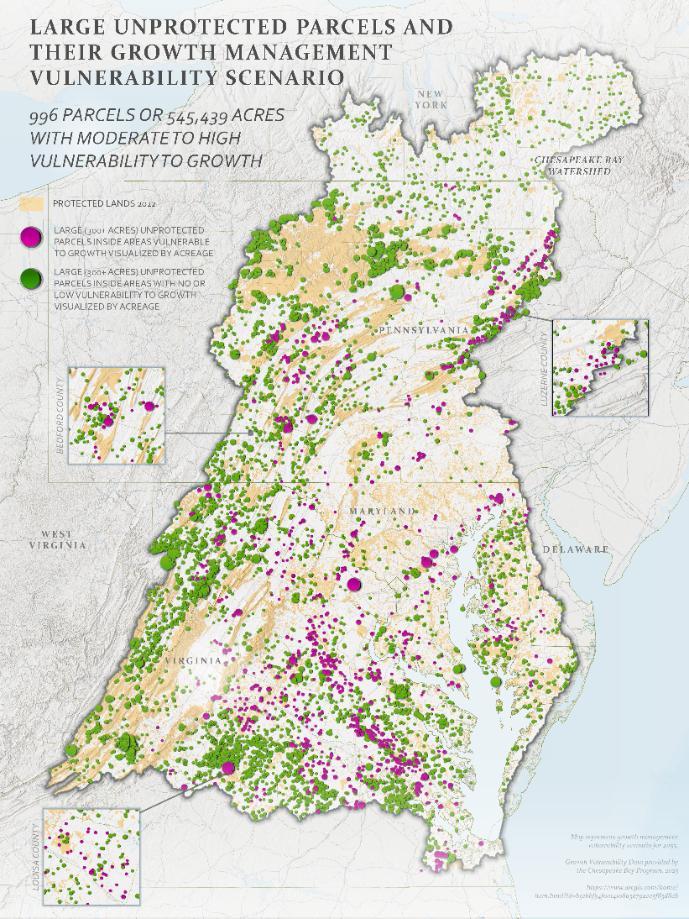
Figure 3.3: Map showing protected and vulnerable lands across the watershed. Protected lands (in yellow) with large, unprotected parcels of land (greater than 300 acres) that are most vulnerable to development (purple). Lands with low vulnerability are shown in green (Source: USGS and CBP).
The Conservancy will also assess the potential effects of climate change to identify HVLs. The Chesapeake Bay and its watershed are vulnerable to climate change impacts, including extreme heat, warming waters, sea level rise, and changing weather conditions. The latter two increase the likelihood of coastal flooding and erosion, while the former can negatively impact aquatic species and entire ecosystems across the watershed.
Water temperatures in the Bay during the summer are rising almost twice as fast as global ocean temperatures. UMCES has reported warmer waters in more than 92 percent of the bay. Stream temperatures in the Chesapeake Bay region have also risen from 1960 to 2010. Many keystone species in the Chesapeake could collapse in warmer waters, including eelgrass, which is an important resource for fish, crabs, and birds. In addition, the absorption of excess carbon dioxide from the atmosphere results in water acidification that prevents oysters and other
shellfish from forming their shells properly, impacting their abundance. A loss of those essential species would in turn affect water quality and habitat.
These impacts and others are already being seen around the watershed. Therefore, it is essential that land conservation practices around the bay and watershed consider those important factors and their future impacts, as well as the land use for adjacent communities (for fishing, hunting, beauty, physical activities, etc.). Initially, the Conservancy will use the heat severity index to assess the potential effects of climate change and could also utilize projections of sea-level rise. The Conservancy will also consider these guidelines for protecting HVLs from the effects of climate change:
• Lands that have healthy wetlands and enough open space for the wetlands to migrate upland
• Lands that are not impacted by saltwater intrusion due to sea level rise or regular droughts
• Lands across the watershed that are near waterways, especially with shade-covered, healthy streams.
• Lands that have healthy, diverse forest that can serve as a buffer for temperatures locally.
• Lands that are not heavily impacted by sea level rise unless they have historical and/or cultural significance and there is a desire to preserve them.
The Task Force recommends using heat severity as the primary data set to assess climate change (Table 3.2). Higher priority would be given to lands that can help mitigate severe heat effects. The heat severity index is based on values calculated by the National Integrated Heat Health Information System (Heat.gov), a collaborative partnership focused on impacts of future climate change, for urban areas. The heat values are a snapshot of average annual temperatures as measured by Landsat 8. Severity is measured on a scale of 1 to 5, with 1 being a relatively mild heat area (slightly above the mean), and 5 being a severe heat area (significantly above the mean).
In addition to the heat severity, additional information about the potential effects of sea-level rise could be considered in coastal areas. The Conservancy could use information about sea-level rise based on projections from Climate Central Maps & Tools | Surging Seas: Sea level rise analysis by Climate Central
-Assess lands that are most vulnerable to development
-Assess potential effects of climate change
Table 3.2: Assess vulnerability of high-value lands
Results from model forecasting results of the probability of development by 2050 across the Chesapeake watershed.
Highest: Land with the highest probability of development would have higher priority for protection.
Medium: Lands having lower probability of development pressure.
Lowest: Lands forecasted not to be developed.
Heat severity. Heat affects the health of people and biota. Severity is calculated on a scale of 1-5, with 1 being a relatively mild heat area and 5 being a severe heat area.
Highest: Lands that can help mitigate severe heat areas
Lowest: lands in relatively mild heat areas.
An example of applying the CIC tool for the criteria in tables 3.1 and 3.2 are shown in the following series of figures, with the CIC tool results for healthy waters (fig 3.4a) and community benefits (3.4b), with an assessment of vulnerability to development (figure 3.4c). The overlapping areas (combined priorities) are shown in fig 3.4d.
Figure 3.4a-d: Maps showing selected criteria of high-value lands and their overlap.
Recommendation: Engage organizations and donors on their interest in acquiring and protecting lands.
This recommendation focuses on the Conservancy engaging organizations and donors to gauge their interest in acquiring and protecting HVLs (fig 3.5). The process involves sharing the priority watersheds and initial portfolio of HVLs within those watersheds with partners to see if they have a mutual interest in land within these places. Discussions about additional benefits of potential HVLs that address partner and donor priorities would be an important part of the process. Based on input from the partners and donors, a subset of 5-10 priority watersheds would be selected with high-value lands. Within these watersheds there would likely be 20-30 HVLs to further evaluate.
Figure 3.5: Process to engage partners and donors to identify priority watersheds and HVLs of the greatest interest to pursue.
The Conservancy Land Protection team would likely have different approaches to engage organizations and donors. The CCP offers an established pathway for engaging organizations, since most are members and have a working relationship with the Conservancy. The Conservancy may focus on engaging with individual CCP members who have an interest in protecting lands where they intersect with HVLs. For example, the Land Protection team may work directly with state agencies, local governments, or NGOs to gauge interest in protecting
HVLs in their respective jurisdictions. Additionally, the Conservancy could further engage the CBP partners working under the Healthy Watersheds Goal team to increase conservation across the watershed. The Land Protection team would also work with the Conservancy’s Development team to assess potential private donors who may want to protect HVLs identified by the Conservancy.
Organizations and donors will have greater interest in the Conservancy’s priority watersheds and HVLs if these places also address their own respective priorities. The Conservancy would interact with organizations and donors to understand the additional benefits these lands provide beyond the criteria developed by the Conservancy. Some additional benefits that are important for other organizations and donors include biodiversity, endangered species, habitat, and cultural heritage. Having this information will strengthen the case for partners to work with the Conservancy to pursue selected HVLs.
The CCP has several mapping tools, some developed with the Conservancy, which identify places that the partners think are important and guide their efforts across the watershed. Some of the tools include the 30x30 dashboard , Chesapeake Conservation Atlas and the Greenspace Equity Mapper. One example of where partners are working across the watershed are the CCP focus areas (Fig 3.6). These results can be used to help identify which organizations the Conservancy should engage with and inform potential locations of priority watersheds and HVLs. The CCP is also working with the growing trend of Conservation Collaboratives that are popping up locally across the watershed that play a critical role of highlighting wildlife management, conservation, restoration, and more for their regions. The CIC mapped out the prominent collaboratives for the Land Trust Alliance here
3.6: Map of Conservation Focal Areas where organizations are focused in the watershed and places of overlap (from the CCP)
Figure
Recommendation: Finalize HVLs to pursue.
This recommendation summarizes the final steps of how the Conservancy will review, prioritize and finalize a set of HVLs to pursue each year (figure 3.7). Within each of the priority watersheds, we anticipate 20-30 HVLs will be evaluated, with individual HVLs brought forward for approval. This recommendation would also apply to opportunities that are brought to us that meet these our high-value land criteria. Once a HVL parcel is approved, the Land Protection team will work with a funding partner to acquire property for long-term protection. Each of the steps are explained, which includes involvement of the Conservancy staff, leadership, and the Board.
3.7: Flow chart of steps 3-5 to finalize, approve, and pursue HVLs
The steps include:
Step 3: Land Protection team review and prioritization. During this step, the Land Protection team will gather information on the costs and benefits of individual HVLs in priority watersheds. The costs of the lands would be determined by working with local consultants and organizations and information gathered from landowners. The Land Protection team would also estimate the staff time needed to pursue, acquire, and transfer the lands. The benefits to be assessed
Figure
include how proposed HVLs meet the Conservancy’s mission, align with partner programs for long-term protection, have political support, and provide additional benefits. The information would be summarized in a cost-benefit analysis and shared with the Conservancy CEO to discuss priorities. To complete this step, the team will assess financial feasibility (availability of government or partner funding, private FR or conservation buyer transactions) for any HVLs working with the Finance team. The Land Protection team will work on the deals for individual HVLs and notify the Conservancy CEO when they are ready to be submitted for approval by the Board.
Step 4: Approve deals to acquire HVLs lands. The Conservancy CEO will bring deals for individual HVLs to the Board for approval, including those identified through the strategy or opportunities brought to us. The Task Force suggests that different financial thresholds be used for approval. Deals under $500,000 may be approved by the CEO; $500,000 to $1M may be approved by the Executive Committee of the Board; and any HVLs over $1M would need approval of the entire Board (see table 3.3). Any deal presented to the CEO or the Board shall include a financial plan for the project which includes, at a minimum, the appraised fair market value of the proposed property and a financial disposition plan showing the ‘sources and uses’ of the funds needed for the transaction, as well as the timing and certainty of securing the needed funds and any endowment funds (sources and amounts) which may be needed.
Table 3.3: Suggested financial thresholds and approval authority for HVLs.
<$500,000
$500,000 to 1M
>$1M
Conservancy CEO with Board notification
Executive Committee of Board reviews and approves
Full Board Approval
Provides leadership flexibility
Quick turnaround approvals possible
Vote of the entire Board required.
Step 5: Land Protection team pursues the HVLs that have been approved. Once approved, the Land Protection team proceeds on land acquisition and finds partners to help with cost and long-term protection. The Finance Committee would be engaged if funds are needed from Conservancy until the lands have been transferred to a partner for long-term protection. The Conservancy CEO reports regularly to the Board on progress, finances, and outcomes. Same financial thresholds would apply.
Appendix A:
Program & Impact Committee: Land Protection Strategy Task Force Charter – updated Feb 6, 2025
Need for a Chesapeake Conservancy Land Protection Strategy: The Chesapeake Conservancy (CC), over its 14-year history, has completed several important land conservation projects. These projects have served multiple functions, including as important additions to existing parks and natural areas, cornerstone projects to facilitate larger conservation actions (such as the foundation of the recent Southern Maryland National Wildlife Refuge), and tangible conservation results for our partners and donors. Often, they are projects that come to the CC through its Giftlands program which accepts both “conservation” lands which are conserved in some way, and non-conservation lands or “tradelands” which are sold without additional protections to generate unrestricted funding for the organization. While these projects add value each in their own way, the CC lacks a strategy to identify lands that we consider the most important to protect.
Charge: The CC wants to develop a holistic strategy, which includes approaches to apply our own criteria to identify and pursue the lands to protect. The Land Protection Strategy will allow the CC staff and Board to be more strategic in seeking investments, using staff resources, and collaborating with potential partners and donors on land protection.
The Land Protection Strategy Task Force, under the Board’s Program and Impact Committee, is charged with developing a comprehensive and cohesive CC strategy for more proactive land protection in the Chesapeake Bay Watershed. This CC Land Protection Strategy should be informed by:
1) The most important land protection priorities of the CC and its Board.
2) The CC Conservation Innovation Center (CIC) priority mapping project that was conducted in 2023-24, and other available data and technology.
3) The niche CC best fills in the context of multiple partners working on land protection across the watershed; and
4) Tells a compelling story of the efforts of the Conservancy’s staff, partners, and donors to protect these important lands.
The Task Force will build upon the findings of recent CIC mapping effort on land protection, which was directed by the Board in 2023. The CIC mapping effort, based on input from the Board and CC leadership, identified five priorities for land protection: Biodiversity, Climate Impacts, Healthy Waters, Equitable Access, and Cultural Heritage. The Website with the mapping can be accessed at: https://cicapps.org/decisionsupport/
Proposed Approach and Key Questions to Address:
● Refine the CC land protection objectives and priorities.
o What is the overarching objective(s) of our work for land protection?
o What refinements should be made to the recent CC priorities for land protection? (see the five priorities listed from the CIC mapping effort)
● Identify 5-10 priority landscapes for the CC in the Chesapeake Bay watershed.
o Where are the revised land protection areas in the watershed?
o What makes these places so important to the CC?
● Improve the CC approaches for protecting lands.
o How can the CC lands protection efforts evolve to be more proactive?
o How does the CC best use mapping data and results in decision-making for land properties?
o How does the CC balance opportunities brought to us (such as the Giftlands program) with being more proactive for the lands we want to protect?
● Increase collaboration with partners on land protection.
o How do the CC priorities compare with land protection priorities of the Chesapeake Conservation Partnership (CCP) and other major partners?
o How do the CC’s land protection efforts contribute towards, and fill a unique niche, efforts by CCP and other partner conservation efforts?
Timeline and Product: The Task Force will begin its work in February with a target completion date of December 2025. Progress on the Strategy will be provided to the Board at their quarterly meetings. A short report of findings and recommendations will be prepared by the Task Force and completed by the December meeting of the Board.
Members (updated Fall 2025):
● Chairperson: Scott Phillips
● Vice-Chair: Stephanie Vaughn
● BOD Members: Astrid Caldas, Philip Tabas and Mike Reynolds
● BOD Advisors: Rich Batiuk and Stephanie Meeks
● CC Staff and Consultants: Mike Evans (interface with CIC on mapping support). Chase Douglas provides input about the Chesapeake Conservation Partnership. Andy Lacatell consults on land protection activities.