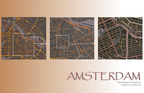
AMSTERDAM Morphological analysis by Nadia A. & Joanna W
INTRODUCTION
AMSTERDAM The analysis is guided by the current locations of embassies and consulates in Amsterdam. The municipality displays a variety of countries represented. The current consulate is located within the Zuid Borough
Neighbouring Consulates and Embassies US Consulate
AMSTERDAM - NOOD BOROUGH
AMSTERDAM WEST BOROUGH
AMSTERDAM - CENTRIUM BOROUGH
AMSTERDAM - OOST BOROUGH AMSTERDAM - ZUID BOROUGH
BOROUGH LIFE
FEATURES US Consulate Landmarks Religious Centers
VISIBILITY
GETTING ANALYTICAL
BLOCK SIZE CONFIGURATION Government Buildings | Museums Schools Retail (Food | Hotels | Businesses) Residential
DENSITY OF THE BUILT STRUCTURES
STRAIGHT LINES through parcel division and lot sizing
through travel routes
Outdoor gun ranges
Petty Crime Map
SAFETY
Vegetation Water Tram Routes
GEOGRAPHY Netherlands is known for its low lying topograpphy, thus a temprate climate affected by its marine location. Amsterdam is intensly urbanized with parks and nature reserves totaling to 12% of amsterdam’s land area. The population desnity os 4457 inhabitants with 2274 houses per square kilometer
https://en.wikipedia.org/wiki/List_of_tourist_attractions_in_Amsterdam#Churches https://www.adequatetravel.com/blog/most-visited-monuments-in-amsterdam/ https://www.dutchamsterdam.nl/1986-amsterdam-boroughs https://www.meetthecities.com/guide/amsterdam/amsterdam-activities-monuments/ https://www.amsterdam.info/churches/ https://www.tripadvisor.com/Attractions-g188590-Activities-c47-t15-Amsterdam_North_Holland_Province.html https://www.embassypages.com/
SOURCES
AMSTERDAM: SELECTION | MORPHOLOGY ANALYSIS NADIA A. & JOANNA W URBAN DESIGN AND PLANNING THEORY PROF EMARL SHPUZA DECEMBER 6TH 2021
INTRODUCTION This paper is a reflection to the research collected to support that the existing United State Consulate in Amsterdam is a fit location for the building- one that seems to have been strategically placed while assessing requirements given to selecting a specific location and land parcel. The analysis also features the discussion of history of Amsterdam, the current building density, and a breakdown of urban layers through three scales of study.
BODY Historical Morphology of Amsterdam. The city presents qualities like Venice – Intricate canal systems. The city, now recognized as a UNESCO World Heritage Site, is based on a canal ring system that resembles a half moon. They were built to fulfil several civic functions and have played a pivotal role within Amsterdam’s history. Founded in 1250, their purpose evolved overtime as the rings expanded. The goal was to have the entire city built around the canals. The purpose breakdown is as is: 1. Middle Ages – They were used for Local transport of merchandise and warehouses were constructed round the canals as storage facilities as well as harbor points. 2. Golden ages - The canals intensified the merchandising monopoly of Amsterdam. At this point they were situated closer to residential areas. 3. Today- Unfortunately, most of the water was lost to landfills, however the transportation aspect of the canals is very much alive – in fact, a tourist attraction since Amsterdam is still the wateriest city in the world. With this discussion, several monuments, sculptures, and museums have been built around the canals. The relevance to this while selecting a consulate shall be brought up later in the report. Amsterdam considers the collection of rings the center of the city and this satisfies the building of the boroughs around the city – or municipality if we are to be politically correct. The boroughs are Zuid, Oost, Centrium, West and Nood.
GEOGRAPHY The geography of the is as previously stated is one that is mostly made up of water. The origin of the terrain of the city came from the marshes and swamps that made up the land before the water was drained and directed into canals that form the many canals and waterways that people use today as another main source of REPRESENTATION OF LAYERS The study is done on three scales. A. An urban scale that encompasses all the boroughs, B. A zoomed in square that focuses on the Centrium and the Zuid borough C. A more zoomed in square of the two boroughs with the focus of the existing US Consulate Location. SQUARE A Within this selection, one can see that Amsterdam is a historically rich area. The West and Zuid Borough are notably residential areas. The Centrium seems to be the Central Business District attracting tourists with landmarks and waterworks as well as being the area with boundaries allocated to retail of various kinds. Most religious centers and landmarks are located within the Centrium and to experience this there is the use of water boats, trams, bicycles, or old-fashioned walking. Amsterdam is a city that embraces pedestrian circulation with minimal vehicular movement. Aside from trams there are trains, and the Zuid Borough is the home to the main train station amongst the boroughs. SQUARE B This selection highlights the political affluence of Amsterdam. Alongside Hague, Amsterdam is home to several consulates and embassies. A pattern highlighted is that most of the government offices are within the Centrium. This may be because the area has direct access to monuments and waterways, highly populated due to businesses and tourism. The host country also has several of its government offices within the Centrium. The city designed a custom drainage system with intricate canal rings. SQUARE C This selection zoomed into the specific attributes that led to the selection of the current consulate location. While most consulates are located within the Centrium Borough, there are a couple outside of the canal rings. Right outside of the outermost canal ring. If that does not seem strategic enough of America. The positioning is right at the entry to what is shared in Square B. ANALYTICAL DATA For this assessment we used Square C to get our data. The block size configuration by the existing consulate is made up of government buildings, museums, schools, retail, and residential
areas. The retail and residential areas seem to be more of a mixed-use building set up. The building lot set up is done in a way where the building is in the central potion and community space is set up all round, unless there is a courtyard of some sort. The street hierarchy retains historical Dutch elements with brick work and similar heights. This is true to the access points closest to the embassy. Those closer to the Van Gogh Museum show a different language. The reason for the change in this language maybe because they are right by the border of the boroughs. The language here has a variety of modern buildings with varying heights as well as visible vegetation on either side of the roads. The city is intensely urbanized with parks and nature reserves. Vegetation is 12% of the topology of Amsterdam. The circulation running between the natural topology and the building make up consists of pedestrian, public and private vehicular movement. A typical street has about 6 feet of sidewalks on both sides of the streets. Instead of a median, there is a middle sidewalk. The vehicle lanes are 2 lanes on both sides of traffic alongside a designated tram route. SAFETY SITE SELECTION We believe the current consulate is at a perfect position. The selection seems to be strategic as the placement is right in front of what brings traffic into Amsterdam. This means access to the building could be a bit easier as compared to placement in the centrium due to less congestion of other government buildings, as well as an opportunity for visiting guests of the consulate from other countries to engage in political activities as well as social activities at a wider range. Amsterdam feels like New York and an opportunity to experience a larger scale of the city by walking seems to be a good deal.
https://en.wikipedia.org/wiki/List_of_tourist_attractions_in_Amsterdam#Churches https://www.adequatetravel.com/blog/most-visited-monuments-in-amsterdam/ https://www.dutchamsterdam.nl/1986-amsterdam-boroughs https://www.meetthecities.com/guide/amsterdam/amsterdam-activities-monuments/ https://www.amsterdam.info/churches/
https://www.tripadvisor.com/Attractions-g188590-Activities-c47-t15-Amsterdam_North_Holland_Province.html https://www.embassypages.com/