6 minute read
Peak Range National Park

FOR A SCENIC DRIVE, TRAVEL ALONG THE PEAK DOWNS HIGHWAY FOR PANORAMIC VIEWS OF THE PEAK RANGE.
THE PEAK RANGE IS A CHAIN OF PROMINENT AND PICTURESQUE VOLCANIC MOUNTAINS BETWEEN MORANBAH, CLERMONT AND DYSART.
Advertisement
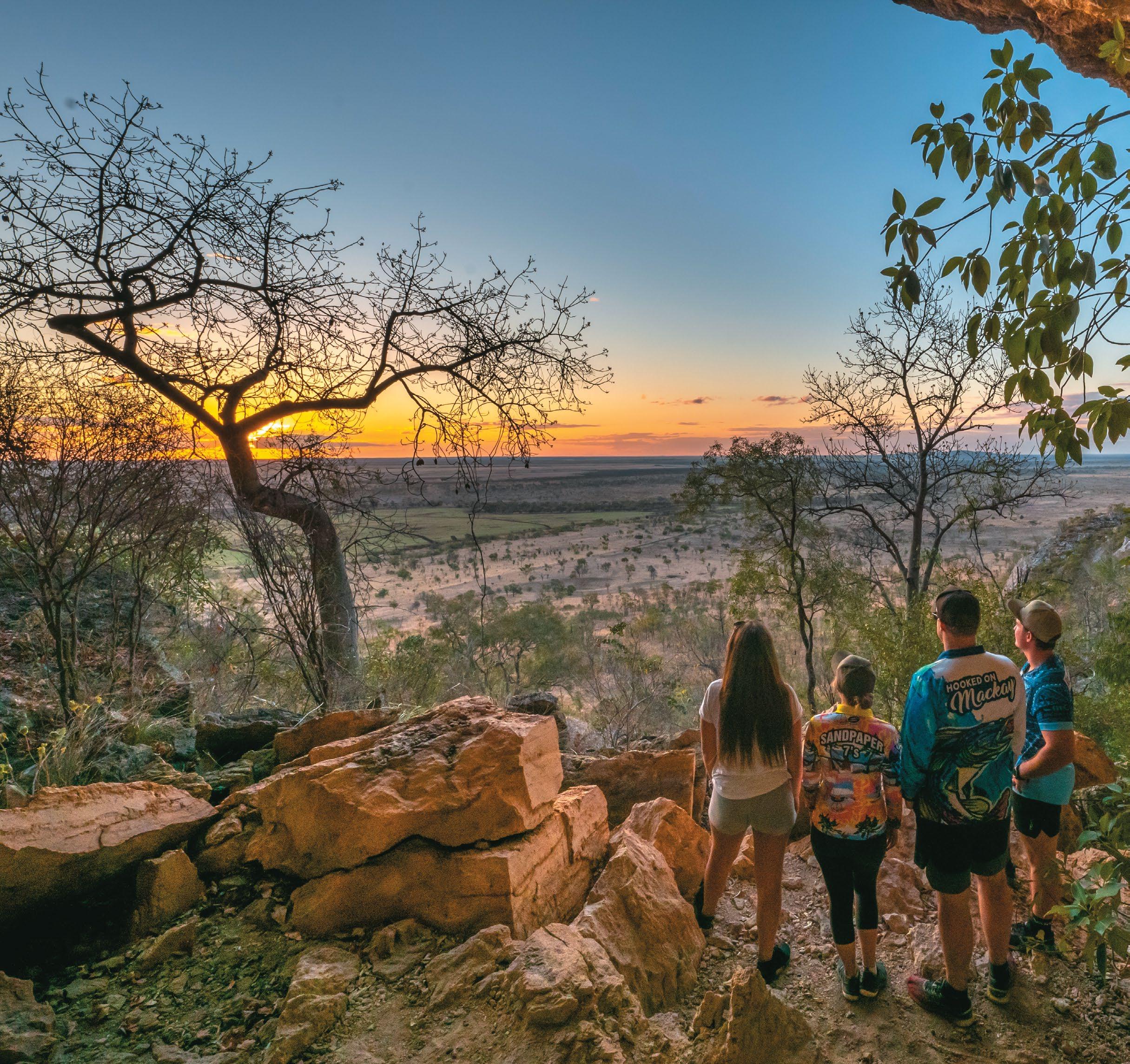
The sharp peaks are visible from a considerable distance across the flat country plains and are most spectacular viewed at sunrise and sunset.
The Peak Range is part of the world’s longest continental volcanic chain, the Cosgrove hotspot. They are a geological marvel and thing of beauty. The Peak Range is underlain by an extensive sequence of basalt flows and rhyolite/ trachyte intrusive bodies, which erupted and emplaced between 26 and 30 million years ago. Visitors to Peak Range National Park enjoy the natural settings through bushwalking, photography, scenic views and exploring the spectacular geological features. There is also historical interest due to the Leichhardt journey passing through the area.
Camping
Camping is prohibited at all peaks.
Site Facilities
The Peak Range National Park and its peaks have limited facilities. Parking space is available near each of the national park roadside entry signs.
Peak Range National Park provides a remote natural setting with no motorised vehicle access, facilities or defined walking tracks. Visitors must be totally self-reliant and have a reliable call in schedule. Fires and camping are prohibited. Please ensure you are environmentally conscious, respectful and remove all rubbish.
Please refer to Queensland Parks and Wildlife for information on National Parks.

WOLFANG PEAK
Towering above the surrounding flat agricultural land at a majestic 572 metres and 172 hectares, it’s Wolfang Peak that catches the eye first as you drive along the Peak Downs highway from Clermont. Its distinct and iconic shape, like a “fang”, gives path to its name. It’s a rhyolite plug once encased in basalt that’s long since eroded away. Located 35 kilometres east of Clermont or 40 kilometres west of Dysart along the Clermont-Dysart Road lays Lord’s Table Mountain. Lord’s Table is the largest and maybe most unique of the peaks. Introduce yourself to the brilliant hues and unusual shapes of this majestic mountain, while marvelling at the peak’s sheer size and scope! Centrally located amongst the Peak Range National Park, the mountain itself is 320 metres high and a flattopped plateau, with Anvil Peak being the highest point, at the southern end. This section compromises 761 hectares It has scenic and geological values ... look out for the giant St Andrews spiders. The peak’s sharp rise can be hazardous and cliff-based activities are not recommended.
The slope below its bare volcanic peak carries an open scrub giving way to open grassland and grassy Eucalyptus
LORD’S TABLE MOUNTAIN
orgadophila woodland. and supports the largest area of dry rainforest in the Peak Range. It was named by Ludwig Leichhardt in 1845 and is mainly open eucalypt woodland, dry vine scrubs and mallee eucalypt at the top of the mountain. Road access to the mountain is via the Huntley road. There is a picnic table and rest area at its scenic base.
Climbing up to the saddle – another track-free endeavour – provides glorious views of the surrounding farmland taking advantage of this rich volcanic soil. Ensure you have a camera and plenty of water.
PEAK RANGE NATIONAL PARK
GEMINI PEAKS
Gemini Mountains is one of four sections that belong to the Peak Ranges National Park group. Other sections include Wolfang Peak, Eastern Peak and Lord’s Table Mountain. The range has been built up by basalt lava flows, which erupted from the Peak Range Volcano, a ‘hot spot’ volcano between 32 and 29 million years ago. The peaks are intrusive volcanic plugs of resistant rhyolite and trachyte. The Peak Ranges form some of the most spectacular scenery in the Central Highlands. Located approximately 45 kilometres east of Clermont, the Gemini Peaks are two volcanic formations with open eucalypt woodland.

FUN FACT
The two Gemini Peaks are called Mount Castor and Mount Pollux and they are named after the twin brothers in Greek and Roman mythology. Together in mythology they are called the Dioscuri.
The spectacular volcanic peaks (Mount Castor and Mount Pollux) are part of the Gemini Mountains section. A national park 787 hectares in size, Gemini National Park is located approximately 60 kilometres east of Clermont on the Peak Downs Highway. The park fronts the northern side of this highway, is sign posted and is best accessed via the gate on the Clermont side of the park. Mount Castor and Mount Pollux are rounded plugs of rhyolite. Mount Castor has long cooling columns and small caverns from erosion of chemically softened rock. The Peak Ranges have significant European cultural heritage value. Ludwig Leichhardt was the first European to sight the range on the January 18th, 1845. Many of the peaks were named after participants and supporters of the Leichhardt expedition. A monument detailing the journey can be found on the Dysart-Clermont Road and survey markers exist on Gemini Mountains. Sheep husbandry was previously one of the main past land-uses in the area. This has subsequently been replaced by cattle and dry land cropping. Of particular interest is the endangered daisy Belyando Cobbler’s Peg or ‘Tiocinica retroflexa’ found in the black soils of the park.
Peak Range National Park provides a remote natural setting with no motorised vehicle access, facilities or defined walking tracks. Visitors must be totally self-reliant and have a reliable call-in schedule.
Parking
There is room to park your vehicle just inside the gate at Gemini National Park when it is dry. The black soil is notorious for getting vehicles bogged when it is wet and we recommend a fine day for undertaking the walk to avoid these wet weather issues.
What to wear and what to take
Wear comfortable, protective footwear – never thongs, high heels, new shoes or dress shoes. Your walk won’t be much fun if you get blisters or sprain an ankle.
Dress for the track conditions and weather. You get warm as you walk so wear layers you can take off easily and replace when you stop and cool down. Light weight, long sleeved shirts and trousers minimise scratches, stings, bites and sunburn. Wear loose clothes – walking in tight clothes is uncomfortable and can cause rashes. Don’t wear clothes you don’t want to get dirty.
Wear a hat and sunscreen to avoid painful sunburn.
Always carry plenty of drinking water. Bushwalking is thirsty work.
Wear insect repellent to discourage biting and sucking insects.
Carry a first-aid kit and know how to use it.
A mobile phone or satellite phone (with spare battery) and/or Personal Locator Beacon (PLB) are recommended for remote bushwalking.
Most importantly, don’t forget your camera.
Be sure to let someone know where you are going, number of people going with you and what time you plan to return. This way the authorities can be alerted if something happens and you do not return as expected.
Brief details of recommended walk
There is no vehicle access within the park. Visitors can walk into Gemini Mountains via fire control lines. There is no marked trail for this walk, the terrain is uneven and good footwear is a must.
The best access with the gentlest gradient up Mount Pollux can be accessed by:
Heading north walking approximately 4.5 kilometres along the western fire break of Gemini.
Follow this fire break over the rise past the neighbour’s dams. Continue until you are just short of a water course that runs between Mount Pollux and Mount Castor where it meets the Western fire break you have been walking on. Leave the fire break at this location and head east for approximately 500 metres until you are between the two main peaks of Mount Pollux and Mount Castor.
You can then head up the gentlest incline on Mount Pollux choosing your own path to the top of the mountain. Once at the top you can return the way you came.
