6 minute read
Exploring science, policy, and 3D catchment printing with a freshwater ecology expert


Isaac Bain is a passionate quantitative freshwater ecologist with knowledge in the domains of data science, statistics, and environmental science. Isaac currently works at the heart of the science-policy interface at the Ministry for the Environment (MfE) in the team responsible for national freshwater policy, where his advice is data-driven and evidence-based. With a deep commitment to bridging the gap between science and policy, Isaac is now channelling his expertise into an innovative project: 3D printing catchments to enhance communication and understanding among stakeholders. We recently caught up with him to find out more about his work and his plans for the catchment project.

What have been some significant challenges you've faced in your area of work, and how did you overcome them?
Collecting environmental data is complex and expensive, and it is a challenge to have enough of it at the right time and place. This challenge is highlighted in successive reports from the Parliamentary Commissioner for the Environment and MfE’ s own environmental reporting, amongst others. Consequently, we’re faced with giving policy advice using incomplete and imperfect information.
Advances in environmental modelling have helped to mitigate this information shortfall. There are good reasons why numerous papers highlight the decades-long gap between the development of technologies in academia and their eventual implementation in decision-making. Increased investment in smarter data collection and innovative modelling is helping to mitigate this.
Can you share a notable project or achievement in your career of which you're particularly proud?
I am proud of the investments MfE has made in acquiring environmental data, which have repeatedly proven valuable. One example is Aqualinc’s mapping of irrigated land throughout New Zealand. Aqualinc’s methods produced a high-resolution dataset of irrigated land area and type, which is not available from other sources. This data has been used for economic studies, predictive modelling, water resource quantification, and even in beautiful cartography (such as in the book We Are Here). The return on investment in environmental data is remarkably high.
What inspired you to use 3D printing technology, particularly in the context of environmental and catchment group projects?
Even as a self-confessed data and policy nerd, I know everyone needs a break from the spreadsheets occasionally. Engaging in a creative outlet outside of my 9 to 5, like 3D printing, allows me some artistic freedom and the opportunity to support passionate catchment groups. In a previous life I worked as a CAD drafter for a yacht company, so I’m pretty interested in manufacturing technologies like 3D printing, laser cutting, and CNC machining. While it’s not practical or affordable to have all these machines at home, 3D printing is what I’m playing with at the moment.
When did the 3D catchment printing project start and why?
This project builds on skills I’ve been developing for years, but offering it as a service to catchment groups is brand new. It’s entirely separate from my day job and serves as a fun hobby that can hopefully benefit

catchment groups. As someone who enjoys freshwater environments through swimming, packrafting, kayaking, and fishing, I have a vested interest in helping catchment groups enhance our watery backyard.
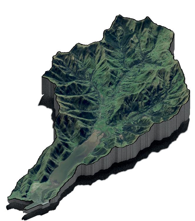
Can you explain how 3D printing works for a catchment, from the outset to the finished product? Is it straightforward?
Each step in the process is fairly straightforward, though it requires linking up several stages. I’ve developed my workflow using the R coding language because it was invented right here in New Zealand, and it is free, open-source, flexible, reproducible, and powerful. However, similar workflows can be implemented in ArcGIS or QGIS (GIS = geographic information system). The basic steps are: (1) define a catchment boundary, (2) source elevation data, (3) process this data into a 3D model, (4) export it as an .stl file for the 3D printer, (5) send it to a 3D printer and hit print.
Steps 1–3 are routine for anyone with GIS experience, and step 5 is a fundamental of all 3D printing. Step 4, the linkage making the entire process possible, is crucial. Many libraries now have 3D printers available for public use, which are often subsidised, charging only nominal fees for consumables. Once you have an .stl file (format that can be printed as 3D) and settings figured out, you can print multiple copies on demand.
You mention it offers a tangible way to communicate complex and geographical topics. Can you explain why this is important?
A 3D model of a catchment provides a commanding overview of topography and its implications on surface water hydrology. Whilst walking around a catchment in real life would offer the ultimate understanding, it can be impractical. Traditional maps offer vast information, but in a more abstract format. The middle ground option of a 3D model helps people visualise in three dimensions, comprehend the scale of sub-catchments, hills, and distances, and see new perspectives. It is second only to flying over the area in a helicopter.
What progress have you seen in the integration of 3D printing in catchment management, and what barriers still exist?
3D printing technology has been financially accessible for hobby use since about 2010. This, combined with community makerspaces and libraries, has made it very accessible. If you’re concerned about the environmental impact, rest assured. The most common filament, polylactic acid (PLA), is made from renewable biomass like corn or sugarcane. The biggest barrier would be GIS technical skills. For non-GIS users, the learning curve to create a 3D elevation model is steep, but there are excellent tutorials and free software like QGIS available.

How does the ability to visualise projects and environments in 3D enhance communication and understanding among stakeholders? What is special about it that offers more than a map, and why does this add value in an environmental sense?
A 3D model allows stakeholders and partners to gather around and discuss catchment goals. While detailed modelling of contaminant pathways and hydrology to prove linkages will always have its place, 3D models serve as communication tools to initiate conversations. Traditional maps complement these models by providing additional context about land use, water quality, soils, etc., so need to be used hand-in-hand.

