International Research Journal of Engineering and Technology (IRJET) Volume: 13 Issue: 09 | Sep 2026
www.irjet.net
e-ISSN: 2395-0056 p-ISSN: 2395-0072
VisionAI: Giving Sight Through Sound – An AI-Powered Real-Time Assistive Navigation System for the Visually Impaired M.D. MANASVINI1, AYUSH SURYAWANSHI1, SHREYAS SRIDHAR2 1 Department of Computer Science and Engineering, Sir M. Visvesvaraya Institute of Technology, Bangalore,
Karnataka, India-562157
2 Department of Data Science and Engineering, Sir M. Visvesvaraya Institute of Technology, Bangalore, Karnataka,
India-562157 ---------------------------------------------------------------------***---------------------------------------------------------------------
Abstract - Getting around safely is a daily difficulty for
VisionAI addresses these points with a self-contained wearable. The paper makes four contributions. First, detection and distance estimation run on a Jetson Nano attached to the glasses, so no laptop or cloud service is needed. Second, an ultrasonic walking stick works as a separate short-range channel, and its reading overrides the camera inside 1 m. Third, detections are ranked by class and distance and spoken as clock-position phrases. Fourth, we describe a dataset of Indian street scenes captured at eye level, with classes such as auto-rickshaws, stray animals, potholes and speed breakers. A Global Positioning System (GPS) and Global System for Mobile Communications (GSM) safety module with an SOS button completes the system.
people with visual impairment, especially on crowded and uneven streets. This paper describes VisionAI, a wearable navigation aid that runs entirely on a small embedded board. A Sony IMX219 camera fixed to a pair of smart glasses sends video to an NVIDIA Jetson Nano, where a YOLOv8n (You Only Look Once, version 8, nano) detector optimised with TensorRT in half precision (FP16) finds obstacles and OpenCV handles the frames. The distance to each object is estimated from the height of its bounding box. A walking stick with an ultrasonic sensor and an ESP32 board covers the short range and the ground level. A logic controller combines both sources, lets the ultrasonic reading take priority inside 1 m, and turns the result into short spoken directions through bone-conduction earphones and vibration on the stick. A Global Positioning System (GPS) receiver, a Global System for Mobile Communications (GSM) module and an SOS button send the user’s position to a chosen contact. The detector was trained on 12,500 frames of Indian street scenes recorded at eye level and reaches a mean average precision (mAP) of 0.875 at an intersectionover-union threshold of 0.5 over four object groups. Ground hazards such as potholes remain the hardest group (0.81). Key Words: Artificial intelligence, assistive technology, computer vision, edge computing, Jetson Nano, object detection, sensor fusion, YOLOv8
1. INTRODUCTION
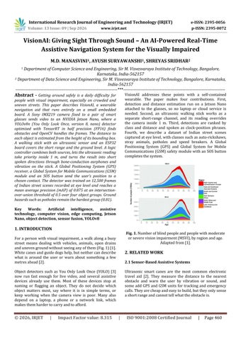
Fig. 1. Number of blind people and people with moderate or severe vision impairment (MSVI), by region and age. Adapted from [1].
For a person with visual impairment, a walk along a busy street means dealing with vehicles, animals, open drains and uneven ground without seeing any of them (Fig. 1) [1]. White canes and guide dogs help, but neither can describe what is around the user or warn about something a few metres ahead [2].
2. RELATED WORK 2.1 Sensor-Based Assistive Systems
Object detectors such as You Only Look Once (YOLO) [3] now run fast enough for live video, and several assistive devices already use them. Most of these devices stop at naming or flagging an object. They do not decide which object matters most, say where it is in simple terms, or keep working when the camera view is poor. Many also depend on a laptop, a phone or a network link, which makes them harder to carry and to afford.
© 2026, IRJET
|
Impact Factor value: 8.315
Ultrasonic smart canes are the most common electronic travel aid [2]. They measure the distance to the nearest obstacle and warn the user by vibration or sound, and some add GPS and GSM units for tracking and emergency calls. They are cheap and easy to build, but they only sense a short range and cannot tell what the obstacle is.
|
ISO 9001:2008 Certified Journal
|
Page 460
International Research Journal of Engineering and Technology (IRJET) Volume: 13 Issue: 09 | Sep 2026
www.irjet.net
e-ISSN: 2395-0056 p-ISSN: 2395-0072
2.2 Vision-Based Systems
3. DATASET AND PREPROCESSING
YOLO [3] and the Single Shot MultiBox Detector (SSD) [4] showed that many objects in a frame can be found in a single pass, which made real-time detection practical. OrCam MyEye [5] is a commercial wearable camera that reads text and recognises faces and products, but it is expensive and is not designed around continuous obstacle warning. Drishti [6] combined a wearable computer, GPS and voice output for outdoor guidance, but it appeared before modern deep-learning detectors.
The model was trained on 12,500 annotated frames. Pretrained weights and base categories come from Common Objects in Context (COCO) [8]. We added frames collected on Indian roads and in indoor spaces, and used BDD100K [9] for extra road-scene variety. 3.1 Classes Objects are placed in four groups according to how they affect a walking user (Table - 2). The grouping was defined by the authors for this application.
2.3 Hybrid Systems Some products mix several sensing methods. WeWALK [7] adds a smartphone link to an ultrasonic cane, which improves everyday use, although its warnings are still mostly reactive and it has no camera-based understanding of the scene. Table - 1 compares these systems with VisionAI.
Table - 2: Dataset taxonomy and operational significance Class Category Dynamic Obstacles
Table - 1: Comparison with representative assistive systems System
Sensing / Output
Ultrasonic Ultrasonic ranging; smart cane vibration or buzzer [2] Ultrasonic cane WeWALK and smartphone [7] navigation OrCam MyEye [5]
Drishti [6] VisionAI (this work)
Gap addressed VisionAI
Infrastructu re
by
Ground Hazards Indoor Utilities
Cannot identify objects or give context
Reactive; no visual object recognition or hazard ranking High cost; built for Wearable camera; recognition, not speech continuous obstacle guidance Wearable No on-device visual computer, GPS, detection voice Camera with Prioritised clockYOLOv8 on Jetson position guidance, failNano, ultrasonic safe haptics and SOS stick, GPS/GSM
Impact Factor value: 8.315
Tracking to avoid collisions with moving objects Cues for crossing and following the street Prevent falls and injuries to the legs Movement inside offices and homes
Frames were recorded in bright sunlight, under overcast skies and at night. The camera was held at 1.5–1.7 m, the height of glasses worn by an adult, so the training views match the real device. Locations included crowded markets, narrow lanes and unpaved residential roads. 3.3 Augmentation During training we rotated images by up to 15°, flipped them horizontally and rescaled them. Hue, saturation and brightness were varied to imitate different times of day and artificial light. Gaussian and motion blur were added to imitate the shake of a walking wearer, which also affects distance estimation.
The systems above either detect obstacles, recognise objects or give simple alerts. We found few that combine on-device detection, distance estimation, a second shortrange sensor and ranked spoken guidance in one low-cost wearable. VisionAI is built to fill this gap for crowded Indian streets.
|
Person, Car, Motorcycle, Autorickshaw, Stray Animal Traffic Light, Zebra Crossing, Signpost, Bench Pothole, Open Drain, Speed Breaker Chair, Table, Door, Stairs, Elevator
Operational Significance
3.2 Collection Conditions
2.4 Research Gap
© 2026, IRJET
Object Labels
3.4 Annotation and Split Images were labelled in the Computer Vision Annotation Tool (CVAT) [10] with a 2D bounding box and a class ID from Table - 2. The data were split into 8,750 training images (70%), 2,500 validation images (20%) and 1,250 test images (10%).
|
ISO 9001:2008 Certified Journal
|
Page 461
International Research Journal of Engineering and Technology (IRJET) Volume: 13 Issue: 09 | Sep 2026
e-ISSN: 2395-0056 p-ISSN: 2395-0072
www.irjet.net
4. SYSTEM ARCHITECTURE
Inference is sped up with a TensorRT [15] half-precision (FP16) engine and Compute Unified Device Architecture (CUDA), and video is captured through GStreamer.
VisionAI has three parts: perception, decision making, and feedback through sound and touch. They work as a continuous loop of sensing, planning and acting (Fig. 2).
4.3 Detection and Distance Estimation YOLOv8 finds all objects in a frame in a single pass, which keeps the frame rate high. We fine-tuned it on the four groups in Table - 2. Distance is estimated from the height of the bounding box, which avoids the cost of stereo cameras or LiDAR (light detection and ranging):
4.1 Hardware Our first prototype used a laptop or Raspberry Pi for processing. The final version replaces it with an NVIDIA Jetson Nano [11], which has a quad-core ARM Cortex-A57 central processing unit (CPU) and a 128-core Maxwell graphics processing unit (GPU) and is small enough to be worn. It runs the pipeline of camera, OpenCV, YOLOv8, distance estimation, decision and voice or haptic output, and it also handles speech synthesis and voice commands. A Sony IMX219 8-MP camera [12] is mounted on the front of the glasses so that the view follows the direction the user faces. The stick carries an ultrasonic sensor, a vibration motor, a buzzer and an ESP32 board [13]. The ESP32 reads the sensor and drives the motor and buzzer on its own, so a nearby obstacle is reported even if the vision pipeline is busy. Bone-conduction earphones give spoken output while leaving ambient sound audible, and a microphone takes voice commands. The safety module holds a GPS receiver, a 4G/GSM modem and an SOS button. A rechargeable lithium-ion (Li-ion) or lithiumpolymer (Li-Po) battery with voltage regulation, USB-C charging and a level indicator powers the system. Table - 3 lists all components.
d ≈ (fpx · Hc) / hpx
(1)
where hpx is the box height in pixels, Hc is a typical real height for the class (for example an average adult) and fpx is the focal length in pixels, found by calibrating the IMX219 once. The horizontal position of the box centre, together with the camera’s field of view, gives the direction, which is converted to a clock position. Table - 3: Hardware components and purpose Component Smart glasses frame
Purpose Wearable base for camera and audio
Sony IMX219 8-MP Real-time image capture camera NVIDIA Jetson Nano Edge AI processing Ground-level and close-range Smart blind stick sensing Ultrasonic sensor and Distance measurement and ESP32 stick control Vibration motor and Haptic and audible proximity buzzer alerts Microphone; bone- Voice commands; spoken conduction earphones guidance GPS module Location and navigation 4G/GSM, Wi-Fi, Bluetooth SOS messages and stick link SOS button Manual emergency trigger Li-ion/Li-Po battery and Portable, stable power regulator Table - 4: Software components and role Software
Role Operating environment and control code Frame capture and preprocessing
Fig. 2. Hardware architecture of the final VisionAI system.
Ubuntu, JetPack, Python
4.2 Software
OpenCV [16], GStreamer
The system runs on Ubuntu with NVIDIA JetPack, and the code is written in Python (Table - 4). YOLOv8n [14] was chosen because it is light enough for an embedded board.
YOLOv8 (Ultralytics, Object detection PyTorch) CUDA, TensorRT, FP16 GPU acceleration of inference
© 2026, IRJET
|
Impact Factor value: 8.315
|
ISO 9001:2008 Certified Journal
|
Page 462
International Research Journal of Engineering and Technology (IRJET) Volume: 13 Issue: 09 | Sep 2026 Software Speech Recognition library pyttsx3 GPS / navigation API Twilio API [17] ESP32 firmware; serial or Bluetooth
www.irjet.net
Role
6. RESULTS AND DISCUSSION
Voice-command input
6.1 Detection Performance
Text-to-speech output Location and direction logic SOS text messages Stick sensing and link to Jetson
The model was tested on COCO images [8] mixed with our own frames of Indian roads. Table - 5 gives the results for each group. The mean average precision at an intersection-over-union threshold of 0.5 (mAP@0.5) is 0.875 and the mean F1-score is 0.862. Chart - 1 compares the fine-tuned model with the base COCO-trained YOLOv8, which was evaluated on the same test images at the same threshold without fine-tuning, and the biggest improvement is for ground hazards.
4.4 Fusion and Decision Logic A Contextual Logic Controller (CLC) receives detections from the camera and range values from the stick. Inside 1.0 m the ultrasonic reading takes priority, so the user still gets a warning when the camera is blocked or the light is poor. Vibration is slow for a moderate distance and fast and strong for a very close obstacle. Outside 1.0 m the controller ranks detections by class and distance, with moving obstacles and nearer objects announced first, and converts them into short phrases such as “Person ahead”, “Obstacle on the left” or “Obstacle at 10 o’clock”. The user can also say “Start navigation”, “Stop system”, “What is ahead?” or “Emergency”.
Dynamic obstacles score best, since people and vehicles are large and stand out from the background. Ground hazards score lowest, mainly because a pothole has little height and looks different from one road to the next. This is one reason the ultrasonic stick is kept as a second sensor. Table - 5: Evaluation metrics of the VisionAI detector Class Category Dynamic Obstacles Infrastructure Ground Hazards Indoor Utilities Macro Average
4.5 Emergency Alerts When the SOS button is pressed, or the user says “Emergency”, the device reads its GPS position and sends a message with the coordinates to a saved contact through the Twilio API over the GSM or internet connection. A physical button is included because speech may not be practical in a real emergency.
5. OPERATIONAL FLOW
mAP@0 .5
0.92
0.90
0.91
0.93
0.88
0.84
0.86
0.87
0.82
0.79
0.80
0.81
0.89
0.87
0.88
0.89
0.878
0.850
0.862
0.875
Table - 6: Pipeline stages and speed-up measures Stage Frame capture Preprocessin g Inference
Impact Factor value: 8.315
F1Score
A navigation aid must respond quickly, so the whole path from frame capture to spoken output was designed to fit within one frame interval of 60–80 ms. Table - 6 lists the stages and what is done in each to save time. The stick’s ESP32 measures distance and drives the motor by itself, so proximity alerts do not wait for the neural network.
1. The camera captures a 640×640 frame every 60– 80 ms. 2. YOLOv8 detects objects and gives each a confidence score, and the stick reports its ultrasonic range. 3. Detections with confidence above 0.5 that lie in the user’s path are given priority. Any ultrasonic reading below 1.0 m overrides them. 4. The instruction is spoken to the user, and the stick vibrates if the obstacle is within 1 m. 5. The user may ask “Where am I?” or “What is in front?” at any time.
|
Precisio Recall n
6.2 Processing Speed
The system repeats the following steps while it is switched on:
© 2026, IRJET
e-ISSN: 2395-0056 p-ISSN: 2395-0072
|
Implementation Speed-up measure IMX219 through Hardware-accelerated GStreamer capture OpenCV resize to Single resize per frame 640×640 YOLOv8n on the TensorRT engine Jetson GPU FP16 with CUDA
ISO 9001:2008 Certified Journal
|
in
Page 463
International Research Journal of Engineering and Technology (IRJET) Volume: 13 Issue: 09 | Sep 2026 Stage Distance and logic Closerange alerts
www.irjet.net
Implementation Speed-up measure Box geometry and Simple arithmetic CLC detections ESP32 ultrasonic Independent of loop vision pipeline
e-ISSN: 2395-0056 p-ISSN: 2395-0072
NVIDIA Jetson Nano running a TensorRT-optimised YOLOv8n model, and an ESP32-based ultrasonic stick. A logic controller combines the two sensors, ranks what they find and gives spoken and vibration guidance, while a GPS and GSM module handles emergencies. The detector reached a mean mAP@0.5 of 0.875 on four object groups. Letting the ultrasonic reading take priority at close range means the user is still warned when the camera cannot see.
on the
6.3 Discussion The fine-tuned model finds auto-rickshaws and stray animals more reliably than a generic COCO model, which shows the value of training on local data. Distance estimates are reliable at close range, which matters most for avoiding collisions, but become less accurate further away because the object covers fewer pixels.
7.2 Future Work
The ultrasonic stick keeps working in low light or when the camera view is blocked, so the system does not depend on one sensor alone.
Next we plan to measure latency, frame rate and power use on the Jetson Nano and to test the device with visually impaired users. Longer-term ideas are simultaneous localisation and mapping (SLAM) for path planning, Vision Transformers for wider scene context, smart lenses on biocompatible hydrogel with embedded micro-sensors, and recycled polymer-aluminium laminates for the glasses frame and stick to reduce their environmental cost.
6.4 Limitations
REFERENCES
Distance from a single camera depends on the assumed real height of each class and on calibration, and it becomes less accurate with range and camera shake. A single ultrasonic sensor covers only a narrow cone. Recall for ground hazards is lower than for the other groups. The Jetson Nano has limited power and cooling, and all results come from one dataset collected in Indian cities. Trials with visually impaired users are still needed.
1) S. R. Flaxman et al., “Global causes of blindness and distance vision impairment 1990–2020: a systematic review and meta-analysis,” Lancet Glob. Health, vol. 5, no. 12, pp. e1221–e1234, 2017. 2) J. Sakhardande, P. Pattanayak, and M. Bhowmick, “Smart cane assisted mobility for the visually impaired,” Int. J. Electr., Comput., Energetic, Electron. Commun. Eng., vol. 6, no. 10, 2012.
Chart - 1: mAP@0.5 and F1-score per class group for base YOLOv8 (COCO) and fine-tuned VisionAI. The VisionAI values are those of Table - 5.
3) J. Redmon, S. Divvala, R. Girshick, and A. Farhadi, “You only look once: Unified, real-time object detection,” in Proc. IEEE Conf. Comput. Vis. Pattern Recognit. (CVPR), 2016, pp. 779–788. 4) W. Liu et al., “SSD: Single shot multibox detector,” in Proc. Eur. Conf. Comput. Vis. (ECCV), 2016, pp. 21–37. 5) OrCam Technologies, “OrCam MyEye.” [Online]. Available: https://www.orcam.com 6) S. Helal, S. Moore, and B. Ramachandran, “Drishti: An integrated navigation system for visually impaired and disabled,” in Proc. 5th Int. Symp. Wearable Comput. (ISWC), 2001, pp. 149–156. 7) WeWALK, “WeWALK smart cane.” [Online]. Available: https://wewalk.io 8) T.-Y. Lin et al., “Microsoft COCO: Common objects in context,” in Proc. ECCV, 2014, pp. 740–755.
7. CONCLUSION AND FUTURE WORK 7.1 Conclusion
9) F. Yu et al., “BDD100K: A diverse driving dataset for heterogeneous multitask learning,” in Proc. IEEE/CVF CVPR, 2020, pp. 2636–2645.
This paper presented VisionAI, a wearable navigation aid made of smart glasses with a Sony IMX219 camera, an
10) OpenCV, “CVAT: Computer Vision Annotation Tool.” [Online]. Available: https://github.com/opencv/cvat
© 2026, IRJET
|
Impact Factor value: 8.315
|
ISO 9001:2008 Certified Journal
|
Page 464
International Research Journal of Engineering and Technology (IRJET) Volume: 13 Issue: 09 | Sep 2026
www.irjet.net
e-ISSN: 2395-0056 p-ISSN: 2395-0072
11) NVIDIA, “Jetson Nano developer kit and technical specifications.” [Online]. Available: https://developer.nvidia.com/embedded/jetson-nano 12) Raspberry Pi Ltd., “Camera Module 2 (Sony IMX219) datasheet.” [Online]. Available: https://www.raspberrypi.com/documentation 13) Espressif Systems, “ESP32 series datasheet.” [Online]. Available: https://www.espressif.com 14) G. Jocher, A. Chaurasia, and J. Qiu, “Ultralytics YOLOv8,” 2023. [Online]. Available: https://github.com/ultralytics/ultralytics 15) NVIDIA, “TensorRT developer guide.” [Online]. Available: https://docs.nvidia.com/deeplearning/tensorrt 16) G. Bradski and A. Kaehler, Learning OpenCV: Computer Vision with the OpenCV Library, 1st ed. Sebastopol, CA, USA: O’Reilly Media, 2008. 17) Twilio Inc., “Programmable Messaging API documentation.” [Online]. Available: https://www.twilio.com/docs
© 2026, IRJET
|
Impact Factor value: 8.315
|
ISO 9001:2008 Certified Journal
|
Page 465