
International Research Journal of Engineering and Technology (IRJET) e-ISSN: 2395-0056
Volume: 12 Issue: 04 | Apr 2025 www.irjet.net p-ISSN: 2395-0072
International Research Journal of Engineering and Technology (IRJET) e-ISSN: 2395-0056
Volume: 12 Issue: 04 | Apr 2025 www.irjet.net p-ISSN: 2395-0072
Animesh Kumar Jayaswal1 , Ar. Gaurav Singh2
1Student of Master in Urban and Regional Planning, Faculty of Architecture and Planning, Dr. A.P.J. Abdul Kalam Technical University, Lucknow, India.
2Professor, Faculty of Architecture and Planning, Dr. A.P.J. Abdul Kalam Technical University, Lucknow, India. ***
Abstract - This study investigates urban riverine flooding in the Ganga Basin, Uttar Pradesh, emphasizing the region’s vulnerability due to rapid urbanization, inadequate drainage, and recurring monsoon floods. Using the Analytical Hierarchy Process (AHP), the study systematically assesses flood risk by evaluating hydrological, topographical, urban development, socio-economic, and environmental factors. AHP enables the prioritization of mitigation measures by structuring complex variables into a hierarchical model. The research advocates for integrating AHP to enhance flood risk analysis and urban planning. Findings highlight the significant influence of socioeconomic and environmental conditions on flood impacts and underscore the need for targeted, data-driven interventions. The study offers a valuable framework for urban planners and policymakers to identify vulnerable zones and implement effective, sustainable flood management strategies. Its insights contribute to global discussions on disaster resilience and urban sustainability, with potential applicability to other flood-prone urban regions.
Key Words: Urban riverine flooding, Vulnerability, Risk, Flood susceptibility, Analytical Hierarchy Process (AHP), Flood vulnerability, Flood risk assessment, Geographic InformationSystem(GIS),RemoteSensing(RS)
1. INTRODUCTION
Urbanfloodingisanincreasinglycriticalenvironmentaland economicissue,especiallyinrapidlyurbanizingregions.It occurswhenintenserainfallorcoastaloverflowoverwhelms drainagesystems,leadingtowidespreadinundation.Factors suchasunplannedurbanization,climatechange,andnatural erosionexacerbatetheproblem.Urbanareas,withtheirhigh populationdensity,poorinfrastructure,andlimiteddrainage capacity, are particularly vulnerable. The Ganges River, stretchingover2,500milesfromtheHimalayastotheBayof Bengal, sustains millions of people but also poses a major floodrisk.Amongthestatesinthebasin,UttarPradeshfaces some of the most severe impacts on health, safety, and livelihoods.
The Ganges Basin, one of the world’s largest, spans about 984,076squarekilometres acrossIndia,Nepal,China,and Bangladesh. In India, it covers several flood-prone states, includingUttarPradesh,Bihar,andWestBengal.Traditional flood management approaches are often inadequate for
dealingwiththecomplexityofmodernurbanenvironments. TheAnalyticalHierarchyProcess(AHP)providesarobust decision-making framework by integrating hydrological, topographical,socio-economic,andlanduseparameters.By structuringthesefactorshierarchicallyandassigningthem relative weights, AHP allows for effective prioritization of risk mitigation efforts. It offers a data-driven, adaptable approachfordevelopingresilienturbanfloodmanagement strategies
India is vulnerable to urban riverine flooding due to its extensivenetworkofrivers.Duringthemonsoonseason,the countrygetsover75%ofitsannualraininashortperiodof time.Thiscausestheriverstooverflowtheirbanksandcause flooding.Thereareadditionalchallengesforurbancenters locatednearrivers.
TheGanga,Brahmaputra,andGodavariaresomeofthemajor riverbasinsinIndia.Billionsofdollarsarelostannuallywhen floods affect millions of people. Despite significant investments in flood control infrastructure, the problem persistsduetopoormaintenance,encroachments,andalack ofintegratedwatermanagement.
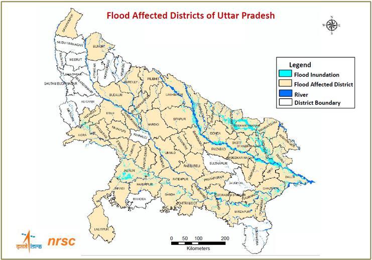
UttarPradeshholdsa central position in theGanga Basin, intersected by major rivers like the Ganga, Yamuna, Ghaghara,Rapti,andGandak.ItsfertileIndo-GangeticPlain supports dense populations and intensive agriculture, but alsoheightensfloodvulnerability.Thestatefacesrecurrent monsoonfloods,withthe2022eventsdevastatingdistricts like Gorakhpur, Balrampur, and Siddharthnagar. These floods were intensified by heavy rainfall, inadequate drainage,andunplannedurbanexpansion.UttarPradeshis the second-most flood-affected state in the Ganges Basin, with sub-basins like the Ghagra and Middle Ganges significantly contributing to its flood risk. Approximately 17.3 million people are exposed to flooding in a two-year return period event, and the state suffers substantial AverageAnnualLosses(AAL).Bothurbancentersandrural areasareatrisk,withhigh-priorityinterventionneededin districtssuchasVaranasi,Prayagraj,Mirzapur,Kanpur,and Ballia. This underscores the urgent need for localized and data-drivenfloodriskmitigationstrategies
International Research Journal of Engineering and Technology (IRJET) e-ISSN: 2395-0056
Volume: 12 Issue: 04 | Apr 2025 www.irjet.net p-ISSN: 2395-0072
Vulnerabilityandriskarefundamentalconceptsindisaster management, environmental studies, and urban planning, particularly in flood-prone regions. While closely related, theyservedistinctpurposesinassessingthepotentialimpact ofnaturalhazardssuchasurbanflooding
Vulnerability refers to the susceptibility of a system, community,orareatoharmwhenexposedtoahazardlike flooding.Itencompassesmultipledimensions:
PhysicalVulnerability:Involvesphysicalcharacteristicssuch as elevation, infrastructure quality, proximity to water bodies, and drainage capacity. Low-lying areas or poorly constructedsettlementsaremorephysicallyvulnerable.
SocialVulnerability:Relatestothedemographicandsocioeconomiccharacteristicsofapopulation.Groupssuchasthe elderly, children, low-income households, and those in informalsettlementsaremoresociallyvulnerable.
EconomicVulnerability:Referstopotentialeconomiclosses fromfloodevents damagetohomes,businesses,jobs,and infrastructure.
EnvironmentalVulnerability:Considersthesusceptibilityof ecosystems and natural resources, such as wetlands and forests, to flood damage, often with long-term ecological consequences.
Contributing Factors to Vulnerability:
Urbanization: Unplanned growth increases impermeable surfaces,encroachmentonfloodplains,andweakdrainage infrastructure.
Hydrology: River behavior, rainfall patterns, and water dischargedetermineflooddynamics.
Topography: Flat or low-lying regions are naturally more pronetowateraccumulationandfloodevents.
Risk is the potential for loss or damage resulting from a hazard. It combines the likelihood of a hazard (such as flooding)withthelevelofvulnerabilityandexposureofthe affectedarea.
Risk Formula:
Risk=Hazard×Vulnerability
Risk=Hazard×Exposure×Vulnerability
Components of Risk:
HazardFrequency/Probability:Therecurrenceoffloodsina specificarea(e.g.,annualmonsoons).
Exposure:Thepresenceofpeople,assets,andinfrastructure inflood-pronezones.
Vulnerability:Thedegreetowhichtheexposedsystemsor communitiescanbeharmed.
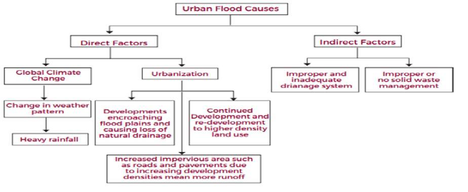
Understanding the key factors driving urban flooding is crucialtomitigatingitswidespreadimpactsonsociety.Urban floodscausesignificantsocio-economicdisruptions,affecting essential services like transportation, power, sewage, and communication,whiledamaginginfrastructure.Theriskof flooding is expected to intensify, particularly in densely populated cities with high-value assets. Two major contributors to this rising threat are climate change and urbanization.Climate change alters the global water cycle, leading to more intense and unpredictable rainfall events. Meanwhile,urbanization drivenbypopulationgrowthand economicexpansion leadstoincreasedimpervioussurfaces likeroadsandbuildings,reducingnaturalwaterinfiltration. Thisnotonlyamplifiessurfacerunoffbutalsoincreasesthe vulnerability of urban populations and infrastructure. Together, these factors strain existing flood management systemsandposechallengesforfutureplanning,highlighting theurgentneedforadaptive,integrated,andforward-looking floodmitigationstrategiesinurbanenvironments.
International Research Journal of Engineering and Technology (IRJET) e-ISSN: 2395-0056
Volume: 12 Issue: 04 | Apr 2025 www.irjet.net p-ISSN: 2395-0072
UrbanfloodinginIndiaarisesfromablendofnaturaland human-induced factors, with anthropogenic influences becomingincreasinglysignificant.Keycontributorsinclude rapidurbanization,unplanneddevelopmentinlow-lyingand hillyareas,andencroachmentonnaturaldrainagesystems. Impervious surfaces and poor waste management overwhelm drainage infrastructure, leading to frequent flooding. Climate change has intensified extreme rainfall events, and the urban heat island effect further increases precipitation in cities. Additionally, the absence of a centralized flood management authority and fragmented policy implementation hinder effective flood mitigation, makingurbanareasmorevulnerabletorecurrentandsevere floodingevents.
Climate change and urbanization are key direct factors contributingtourbanflooding.Globalclimatemodelspredict a significant rise in global temperatures by the end of the 21st century, with India already experiencing a warming trend of 0.62°C per century. Rising temperatures increase atmosphericmoisture,resultinginheavierrainfallandmore frequent extreme weather events, such as storms and cyclones.
Urbanizationexacerbatesfloodingbyincreasingimpervious surfaces like roads and pavements, which prevent water infiltration and accelerate surface runoff. The removal of vegetation and natural absorption areas during development, combined with dense construction, further intensifiestheimpact.Additionally,urbangrowthdisrupts naturaldrainagesystems,heighteningfloodrisks.
Encroachmentsonriverfloodplainsposeamajorchallenge. Despite devastating floods in India such as those in Mumbai(2005),Kedarnath(2013),andChennai(2015) there remains no strict legal protection for floodplains. Theseareasnaturallyallowriverstodisperseexcesswater, but illegal settlements restrict river expansion, leading to severe flooding. Government inaction has worsened this issue, as highlighted by reports showing widespread encroachmentofurbanwaterbodiesandpoorenforcement againstviolators.Collectively,thesehuman-inducedfactors significantly elevate the frequency and severity of urban floods.
Poorurbanplanningisamajorindirectfactorcontributing to flooding in India. Inadequate drainage systems, rapid urban growth, and unregulated development have intensified vulnerabilities. Expanding impervious surfaces disrupt natural ecosystems, reduce water absorption, and increase flood risks, especially in low-lying areas. Despite governmentefforts,urbanplanninglackscohesion,leading tohazardoussettlementsandenvironmental degradation. From1915to2015,Indiafaced649majordisasters 47%
ofthemfloods impactingover40millionhectaresoffloodpronelandacrossthecountry.
Urban floods pose serious threats to cities, affecting lives, infrastructure, and economic activity. Flooding can range from local disruption to widespread inundation, causing fatalities, property damage, and health risks. Losses are categorized as tangible and intangible. Tangible losses include direct structural damage and indirect economic disruptions.Intangiblelossesinvolvelifeloss,healthissues, environmentalharm,andpost-floodpsychologicaltrauma. The cascading effects of floods strain emergency services, hinder recovery efforts, and highlight the urgent need for resilienturbanplanning.
3.1 “Flood Vulnerability Analysis and Risk Assessment Using Analytical Hierarchy Process (AHP)”
Thestudyfocusesonfloodvulnerabilityandriskassessment in Paschim Medinipur, a district in West Bengal, India, particularly prone to flooding due to the presence of four major river basins Kangsabati, Kaliaghai, Silabati, and Subarnarekha. Among these, the first three basins are notablymorevulnerabletoflooding.Thedistrictexperiences frequent flood events between July and October, largely driven by monsoonal rains. In this context, the study employstheAnalyticalHierarchyProcess(AHP)toperform amulti-criteriadecisionanalysis,combiningphysical,social, and coping capacity indicators to assess flood risk and prioritizeinterventionareas.
The primary objective of the research is to systematically identify,classify,andquantifytheelementsatrisk,focusing onthepopulation'svulnerabilityandcopingmechanismsin floodplain areas. The study incorporates the concept of vulnerability as the potential for loss or damage due to exposuretohazards,whileriskisdefinedasthelikelihoodof suchlossoccurringinagivenhazardscenario.
Themethodologyinvolvescollectingdataacrossthreemain dimensions physical, social, and coping capacity factors. These include topographical data (elevation, land use, geology,proximitytorivers),demographicdata(population density,agedistribution,poverty,housingtypes,literacy), anddisasterpreparednessmetrics(awareness,shelterand hospitalavailability).Eachfactorisassignedaweightusing AHP through systematic pairwise comparisons, ensuring consistencyandaccuracyindecision-making.Theweighted factorsareintegratedintothreeseparateindices Physical VulnerabilityIndex(PVI),Social VulnerabilityIndex(SVI), andCopingCapacityIndex(CCI) whicharethencombined usinga WeightedLinearCombination(WLC)technique to produce the Composite Vulnerability Index (CVI).
International Research Journal of Engineering and Technology (IRJET) e-ISSN: 2395-0056
Volume: 12 Issue: 04 | Apr 2025 www.irjet.net p-ISSN: 2395-0072
Geographic Information System (GIS) tools are used throughout to visualize spatial distribution and produce floodriskmapsatcommunitylevels.
Physical vulnerability factors reveal that areas below 30 metersinelevationarehighlysusceptibletoflooding.Land usedatashowthatcultivatedlandsareatsignificantrisk,as flood-induced agricultural loss directly affects rural livelihoods. Proximity to active river channels increases floodexposure areaswithin0.5kmofriversaremostat risk. Geological features are also examined: floodplain depositsarethemostflood-prone,followed byareaswith sandyandclayeysoils.
Thestudyplacessignificantemphasisonpopulationdensity, identifyingdenselypopulatedareasasmorevulnerabledue to evacuation challenges and greater potential impact. Vulnerablegroupsincludechildren(especiallythe0–4age group) and the elderly (above 60 years), who face heightened risks during emergencies. Economic vulnerability is reflected in poverty levels, with poorer communities having fewer resources to respond to and recoverfromfloods.Housingtypesalsoplayacrucialrole katcha(temporary)structureslocatednearwaterbodiesare particularlysusceptibletodamage.Furthermore,illiteracy correlates with reduced disaster preparedness, and poor sanitationincreaseshealthriskspost-flooding.
Thestudydevelopsfloodriskmapsthathelpvisualizehighrisk zones and support targeted disaster mitigation strategies. Approximately 24.25% of the population in PaschimMedinipuris found toresideinhigh tovery high flood-riskzones,predominantlylocatedinthesouthernand southeasternparts,especiallytheGhatalsub-division.This region's vulnerability is attributed to its low elevation, proximity to rivers, high population density, and concentration of economically and educationally disadvantaged groups. The key vulnerable demographics includeindividualslivinginpoverty,thosewithlowliteracy levels,andresidentsofnon-durablemudhouses.
The study demonstrates the effectiveness of AHP in integratingmultiplelayersofvulnerabilityandriskdatainto a coherent, actionable framework. By combining spatial, physical,andsocio-economicindicators,theanalysisoffersa nuanced understanding of flood vulnerability in Paschim Medinipur.TheresultingCompositeVulnerabilityIndexand floodriskmapsserveasessentialtoolsforurbanplanners, policymakers,anddisastermanagementauthorities.These toolsenabletheidentificationofthemostat-riskareasand populations, guiding resource allocation, emergency response, and long-term flood mitigation planning. The methodology is replicable and can be adapted for use in otherflood-proneregions,makingitavaluablecontribution todisasterriskreductionstrategies.
3.2 “FloodhazardriskzoningthroughAHP,GIS,and RS: A case study of Ramganga River Basin (India)”
The study titled “Flood Hazard Risk Zoning through AHP, GIS,andRS:ACaseStudyofRamgangaRiverBasin(India)” presentsanintegratedapproachtoidentifyingandassessing flood hazard zones using Analytical Hierarchy Process (AHP), Geographic Information System (GIS), and Remote Sensing(RS)tools.FocusingontheRamgangaRiverBasin, which stretches across parts of Uttarakhand and Uttar Pradesh, the research addresses the increasing threat of floodsintheregion aggravatedbynaturalconditionsand anthropogenic influences such as rapid urbanization and deforestation.
A combination of spatial and non-spatial data forms the foundationofthestudy.Non-spatialdataweresourcedfrom the Census of India (2011), while spatial data included Sentinel satellite imagery, SRTM DEM, soil maps, geomorphologicalandgeologicaldatafromGSI,andclimatic recordsfromWorldClimate.Thesedatasetswereprocessed andanalyzedusingArcGIS
Theprimaryobjectiveoftheresearchistodelineateflood hazardzoneswithinthebasinusingamulti-criteriadecisionmakingframework.Fourteenparameterswereidentifiedas critical to flood vulnerability, encompassing physical (elevation, slope, drainage density, land use, soil), environmental(precipitation,climatevariability),andsocial indicators(populationdensity,infrastructure,accessibility). TheAHPmethod wasemployed toassign weights to each criterion through pairwise comparisons, ensuring a structured and objective prioritization of factors. These weights were then integrated with spatial data through a GIS-based Weighted Overlay Analysis, leading to the generationofaFloodHazardRiskMap.
The study area exhibits complex geomorphological and geological features, including structural hills, valleys, and alluvial plains, shaped by tectonic activity, erosion, and sediment deposition. Geological structures such as the HimalayanFrontalFaultandMainBoundaryThrustfurther influence hydrological patterns. Land use and land cover (LULC) changes particularly deforestation and urban expansion playacrucialroleinexacerbatingfloodrisksby reducing infiltration and increasing runoff. Similarly, soil types rangingfrommountainsoilsinhigh-altitudezonesto alluvial soils in the plains affect water retention and erosionsusceptibility.
Accessibilityandpopulationdistributionwerealsoassessed, usingmodelslikeAccessMod5,tounderstandtheeasewith which communities can evacuate or access flood relief duringemergencies.Highpopulationdensitiesand poorly developed infrastructure increase both exposure and vulnerability.Hydrologicalandtopographicparameterssuch as drainage density, surface slope, elevation, aspect, planform curvature, Slope Position Index (SPI), and
International Research Journal of Engineering and Technology (IRJET) e-ISSN: 2395-0056
Volume: 12 Issue: 04 | Apr 2025 www.irjet.net p-ISSN: 2395-0072
Topographic Wetness Index (TWI) were meticulously analyzedtounderstandwaterflow,accumulationpotential, andrunoffdynamics.
Keyfindingsofthestudyincludethesuccessfulzoningofthe basin into five flood risk categories: Very High, High, Moderate,Low,andVeryLow.Approximately10.2%ofthe regionfallsunder"VeryHighRisk,"and17.8%under"High Risk,"highlightingareasthatneedurgentfloodmanagement interventions. The study illustrates the effectiveness of combining AHP for decision support, GIS for spatial visualization, and RS for accurate terrain mapping. The resulting flood hazard maps serve as crucial tools for policymakers, planners, and disaster management authorities in devising evacuation plans, infrastructure design,andland-useregulations.
In conclusion, the study demonstrates that AHP-GIS-RS integration provides a scientifically robust and scalable methodology for flood hazard assessment. It supports proactiveriskmitigation,especiallyinecologicallysensitive and densely populated regions like the Ramganga River Basin.Bycombining multi-dimensional criteria physical, social,andenvironmental theframeworkensuresaholistic understanding of flood risks, thus promoting sustainable regionalplanninganddisasterresilience.
3.3“FloodVulnerabilityAssessment Using AHPand Frequency Ratio Techniques”
Thestudytitled“FloodVulnerabilityAssessmentUsingAHP and Frequency Ratio Techniques” explores the complex dynamics of flood risk in the Torsa-Raidak River Basin, located in northeastern West Bengal, India. With floods being one of the most destructive hydro-meteorological hazards globally affecting around 170 million people annually the research aims to develop a robust, geospatiallydrivenmodelforfloodvulnerabilityassessment. Using a combination of the Analytical Hierarchy Process (AHP)andFrequencyRatio(FR)techniques,supportedby GeographicInformationSystem(GIS)andRemoteSensing (RS)tools,thestudyidentifieskeyflood-contributingfactors andquantifiestheirspatialinfluenceonflood-pronezones.
The Torsa-Raidak integrated basin spans approximately 12,316 km², encompassing parts of Bhutan and India, includingthedistrictsofAlipurduarandCoochBehar.The regionisgeographicallycharacterizedbyanorth-southslope gradient, transitioning from high elevations in Tibet and BhutantoflatplainsinWestBengal.Thebasinexperiences heavy monsoonal rainfall, making it highly susceptible to recurrent flooding. For this study, six critical parameters wereselectedtomodelfloodrisk:elevation,slopegradient, topographic wetness index (TWI), rainfall, land use/land cover (LULC), and proximity to rivers. These factors were analyzedusing geospatial data togeneratethematic maps thatinformedthevulnerabilityanalysis.
Toprioritizetheinfluenceofeachfactor,theAHPmethod was used to assign relative weights through a structured pairwisecomparisonmatrix,followedbyconsistencyratio checkstovalidatetheweightingscheme.Concurrently,the FR model was employed to establish the statistical relationshipbetweenhistoricalfloodoccurrenceandeach contributingfactor.Historicalflooddata sourcedfromthe National Remote Sensing Centre identified 156 floodaffectedlocations,ofwhich75%wereusedfortrainingthe modelandtheremainingforvalidation.TheAreaUnderthe Curve (AUC) method was applied to evaluate the model's predictiveaccuracy,confirmingthereliabilityofthederived floodsusceptibilitymaps.
The analysis revealed that rainfall is the most influential factor in flood generation, with more than 90% of annual precipitationoccurringduringthemonsoonseason.Floodprone zones were strongly associated with areas of low elevation, gentle slopes, and close proximity to rivers. Furthermore,landusechanges particularlythepresenceof agriculturallandsandsandbars werefoundtoexacerbate floodrisksduetoreducedinfiltrationandincreasedsurface runoff. The combined AHP and FR approach produced a Flood Vulnerability Index (FVI) that categorized the basin intovariousrisklevels,identifyingapproximately27.84%of thetotalareaasbeingunderhightoveryhighfloodrisk.The districtsofAlipurduarandCoochBeharwerefoundtobethe most vulnerable, with recurring flood events causing widespreadsocioeconomicdisruption.
Beyond rural implications, the study offers significant insights for urban flood management. The AHP model proved effective in integrating diverse environmental and anthropogenicvariables,allowingforinformedprioritization offloodriskfactors acriticalneedinurbanplanningwhere infrastructure decisions must balance development and hazard mitigation. The study highlights how land use changes, especially urban expansion with impervious surfaces,intensifyfloodvulnerability.TheinclusionofLULC and proximity to rivers aligns closely with urban flood studies,wherelandtransformationandriverencroachment aremajorriskamplifiers.
Moreover, the integration of high-resolution spatial data through GIS and RS provided a scalable and replicable approach for urban flood vulnerability mapping. The topographical analysis underscored that flat terrains and low-lying areas are inherently more susceptible to inundation,emphasizingtheneedforelevation-basedzoning andeffectivestormwaterdrainagedesigninurbansettings. The study also brought attention to socioeconomic vulnerability, noting that low-income groups are disproportionatelyaffectedbyfloodsduetotheirsettlement in high-risk areas and limited access to resources for recovery.
Inconclusion,thisstudydemonstratestheeffectivenessof combining AHP and FR models within a geospatial
International Research Journal of Engineering and Technology (IRJET) e-ISSN: 2395-0056
Volume: 12 Issue: 04 | Apr 2025 www.irjet.net p-ISSN: 2395-0072
frameworktoassessfloodvulnerability.Themethodology successfully integrates physical, climatic, and humaninduced factors, offering a holistic understanding of flood risk.Thefindingsprovideavaluablefoundationfordisaster risk reduction strategies, urban resilience planning, and policy development. Most importantly, the approach underscores the need for multi-criteria decision-making, high-resolution data, and equity-focused planning in managingthegrowingchallengesoffloodriskinbothrural andurbanriverineenvironments.
The Analytic Hierarchy Process (AHP) is a structured decision-makingmethodologythathelpsincomparingand evaluatingcomplicatedoptionsbywayofbreakingdowna troublerightintoahierarchyofsub-troublesorstandards.It becameadvancedthroughThomasL.Saatyinthe1970sand has seeing that been broadly utilized in various fields, togetherwithurbanmakingplans,dangermanagement,and environmentalevaluation.
Hierarchical Structure: AHP breaks down a trouble into a hierarchicalshape,beginningfromthegeneralintentionon the pinnacle, followed by using standards, sub-standards, and options at the decrease tiers. This facilitates in organizingthetroubleinascientificmanner.
Pairwise Comparison: The center of AHP includes making pairwisecomparisonsbetweentheelementsateachlevelof thehierarchy.Theselection-makersevaluatetwofactorsata timeandinvestigatetheirrelativesignificanceordesirethe usageofascaleofvalues.Thescaledegreesfrom1(identical importance) to nine (extremely more essential), wherein values like 3, 5, and 7 constitute intermediate ranges of importance.
Mathematical Consistency: AHP uses mathematical techniques to mixture the outcomes of pairwise comparisons.Thesystemensuresthatthecomparisonsare steady and that the judgment made by means of the selection-makersisreliable.
The Analytic Hierarchy Process (AHP) can be extremely useful in assessing urban riverine flood risk and vulnerability, as it allows for a structured, systematic evaluationofthecomplexinterplayoffactorsthatcontribute tofloodrisk.Here'showAHPcanbeappliedinthisstudy.
The primary goal of the study is to assess flood risk and vulnerabilityinurbanareasalongtheriverineregionsofthe Gangabasin,particularlyinUttarPradesh.
Thekeyfactorsorcriteriainfluencingfloodvulnerabilityin urbanareascanbeidentifiedas:
UrbanizationPatterns:Thisincludesfactorslikepopulation density,landusepatterns,infrastructure,andurbansprawl.
Hydrology:Factorssuchasriverdischarge,floodfrequency, riverbankerosion,andseasonalvariationsinwaterlevels.
Topography: Physical characteristics of the land, such as elevation,slope,andproximitytotheriver,whichdetermine howwaterflowsandaccumulatesduringfloods.
Socio-Economic Factors: Vulnerability of certain groups basedonincome,health,andsocialconditions.
EnvironmentalFactors:Detrimentalenvironmentaleffectsof flooding can include soil and bank erosion, bed erosion, siltation or landslides. It can damage vegetation and pollutants carried by flood water can impact on water quality,habitatsandfloraandfauna.
Experts or stakeholders can compare the importance of thesecriteria.Forexample:
Urbanizationpatternsmightbeconsideredmoreimportant than topography in flood vulnerability analysis because urbanization often leads to poor drainage systems and encroachmentonfloodplains.
Hydrology could be ranked higher than socio-economic factorsifthefocusisonthephysicalfloodhazarditself.
Basedonthepairwisecomparisons,weightsareassignedto eachofthecriteria.Forexample,therelativeimportanceof urbanizationpatterns(weight=0.4),hydrology(weight = 0.3),topography(weight=0.2),andsocio-economicfactors (weight=0.1)couldbecalculated.
The weighted scores for each city location are computed through multiplying the criteria weights by means of the scores.Thefinalratingwouldshowwhichurbanregionsare maximumatriskofflooding.Theregionwiththeverybest ratingwillbethemaximumpronetoriverineflooddanger. BenefitsofAHPinFloodRiskandVulnerabilityAnalysis:
Systematic and Transparent: AHP gives a clear, based technique to comparing complicated flood chance and vulnerabilityelements.
International Research Journal of Engineering and Technology (IRJET) e-ISSN: 2395-0056
Volume: 12 Issue: 04 | Apr 2025 www.irjet.net p-ISSN: 2395-0072
IncorporatesExpertJudgment:AHPisbasedonprofessional opinionsthatistreasuredwhilstpreciseinformationmaybe missingorwhilesubjectiveelementslikenetworkresilience orinfrastructurenicearedifficulttoquantify.
Multi-CriteriaDecisionMaking:Itallowsfortheattentionof more than one criteria concurrently, that is crucial in city flood risk evaluation wherein various factors (social, physical,environmental)haveinteraction.
HelpsPrioritizeAreasforIntervention:Byratingcityregions based on their vulnerability and danger, AHP allows prioritize places that need greater immediate flood mitigation efforts, coverage changes, or infrastructure improvements.
Flood risk in urban riverine regions is influenced by a combination of hydrological, topographical, urban development, socio-economic, and environmental factors. Understandingtheseparametersiscrucialforeffectiveflood managementandmitigationstrategies.
TheimportantmainFactorsandtheircorrespondingsubfactors for Uttar Pradesh urban riverine region identified fromtheliteraturestudyare:
Hydrological Factors
Rainfall Intensity: Heavy rainfall can quickly overwhelm drainagesystems,leadingtoflooding.
Rainfall Duration: Prolonged rainfall saturates the soil, reducingitsabilitytoabsorbwaterandincreasingrunoff.
River Discharge: High volumes of water flowing through riverscancausethemtooverflow,floodingnearbyareas.
Topographical Factors
Slope: Steeper slopes lead to faster water flow, increasing theriskoferosionandflashfloods.
SoilPermeability:Soilswithhighpermeabilityabsorbmore water,reducingrunoff,whilelowpermeabilitysoilsleadto highersurfacerunoff.
Elevation: Low-lying areas are more prone to flooding comparedtoelevatedregions.
Urban Development Factors
ImperviousSurfaces:Urbanareaswithsurfaceslikeconcrete andasphaltpreventwaterinfiltration,increasingrunoff.
Drainage Infrastructure: Effective drainage systems are essentialformanagingexcesswater.Poorinfrastructurecan exacerbateflooding.
LandUse:Denseconstructionand limited greenspaces in urbanareascontributetohigherfloodrisks.
Socio-Economic Factors
PopulationDensity:Higherpopulationdensitiesincreasethe potential impact of floods, leading to more casualties and propertydamage.
Economic Value of Exposed Assets: Financial losses are higherinareaswithvaluableassets.
VulnerableCommunities:Disadvantagedgroupsoftenreside in flood-prone areas and have limited resources for recovery.
Environmental Factors
Vegetation Cover: Dense vegetation helps absorb water, reducingrunoff.Lossofvegetationincreasesfloodrisk.
River Channel Condition: Well-maintained river channels canhandlelargerwatervolumes,whileblockedchannelscan overflow.
FloodplainEncroachment:Humanactivitiesinfloodplains, such as construction, can alter natural water flow and increasefloodrisk.
Using Analytical Hierarchy Process (AHP) a hierarchy of abovementionfactorswhichinfluencevulnerabilityandrisk forriverinefloodinUttarPradeshisbeencreated,whichwill helptoidentifytheareawitharemostvulnerableandrisk proneifthesefactorsarecheckedforthesame.
Table -1: Mainfactorsinfluencingvulnerabilityandrisk forriverineflood
International Research Journal of Engineering and Technology (IRJET)
Volume: 12 Issue: 04 | Apr 2025 www.irjet.net
Table -2: WeightageCalculationofhydrologicalsubfactorsinfluencingvulnerabilityandrisk
Sub-Factors
Table -3: WeightageCalculationoftopographicalsubfactorsinfluencingvulnerabilityandrisk
Table -4: WeightageCalculationofurbandevelopment sub-factorsinfluencingvulnerabilityandrisk Sub-Factors
Table -5: WeightageCalculationof
Table -6: WeightageCalculation
8. IMPLICATIONS OF STUDY FOR GANGA BASIN IN U.P.
TheGangaBasininUttarPradeshfacessignificantfloodrisks duetoextensiveurbanization,highpopulationdensity,and hydrologicalvariability.Applyingthefindingsofthereportto thiscontext:
1.UseofAHPforRiskPrioritization
AHPcanhelprankimportantfloodthreatfactorspreciseto the Ganga Basin, together with severe monsoonal rainfall, proximitytomostimportantrivers(e.g.,Ganga,Ghagra),and
International Research Journal of Engineering and Technology (IRJET) e-ISSN: 2395-0056
Volume: 12 Issue: 04 | Apr 2025 www.irjet.net p-ISSN: 2395-0072
urban improvement styles. The method allows for tailormade mitigation techniques by identifying the maximum influentialelementsincityfloodvulnerability.
2.FloodRiskMappingforHigh-RiskZones
UsingGIS,floodsusceptibilitymapscanbecreatedformain urbancentersinUttarPradesh,suchasVaranasi,Prayagraj, Kanpur,andBallia,whichmightbeoftenlaidlowwithGanga floods. These maps can manual land use planning, zoning regulations, and infrastructure improvement to decrease publicity.
3.AddressingAnthropogenicImpacts
Urban regions alongside the Ganga have witnessed fast increase, main to impervious floor enlargement and decreasedinfiltrationcapacity.Thereneedforinexperienced infrastructure answers, such as Permeable pavements, Retentionbasins,Restorationofherbalfloodplains.
4.InclusionofSocioeconomicFactors
VulnerablecompaniesinUttarPradesh,especiallytheonesin casualsettlementsoreconomicallyweakersections,require centered interventions, consisting of Construction of community flood shelters, Improvement in early caution systems&Enhancedgetentrytoassetsduringfloodevents.
5.ImprovedPolicyFramework
Policymakers can use the AHP-based method to allocate sources more efficaciously, focusing on flood-susceptible zonesdiagnosedthroughvulnerabilityindices.Incorporating AHPintocatastrophemanagementplansmightmakecertain data-drivenselection-making.
6.ClimateChangeAdaptation
With changing rainfall styles due to weather change, the GangaBasinfacesgrowingflooddangersthereforedynamic elementslikerainfallintensityandfrequencyisspecifically applicableforpreparinglong-termmitigationtechniques.
9. CONCLUSIONS
The study highlights the effectiveness of the Analytical HierarchyProcess(AHP)asastructuredmethodforflood risk analysis by enabling the prioritization of key vulnerability factors such as elevation, slope, rainfall, and land use.WhenintegratedwithgeospatialtoolslikeGISand RemoteSensing,AHPenhancestheaccuracyofidentifying high-riskfloodzonesbycombiningenvironmental,physical, andspatialdata.Itdemonstratesthatareaswithflatterrain, lowelevation,andproximitytoriversareespeciallyproneto flooding, emphasizing the importance of topographical analysis.Humanactivitiessuchasurbanizationandlanduse changesfurtherexacerbatefloodrisksbyincreasingsurface runoffandreducingwaterabsorption.
The study also stresses the unequal impact of floods on socioeconomically disadvantaged groups, highlighting the needtoincludesocialvulnerabilitiesinfloodmanagement strategies. Overall, the findings underscore the value of a multi-criteria, spatial approach for creating reliable flood vulnerabilitymapsandsupporttheuseofsuchframeworks fordisasterpreparednessandsustainableurbanplanningin flood-proneregions.
[1] R. Ramanathan, A note on the use of the analytic hierarchyprocessforenvironmentalimpactassessment, Journal of Environmental Management, Volume 63, Issue1,2001,ISSN0301-4797.
[2] Kumar,R.;Kumar,M.;Tiwari,A.;Majid,S.I.;Bhadwal,S.; Sahu,N.;Avtar,R.AssessmentandMappingofRiverine Flood Susceptibility (RFS) in India through Coupled Multicriteria Decision Making Models and Geospatial Techniques.Water2023,15,3918.
[3] Causes, impacts, risk and mitigation of Urban Flood Management in India by Dr Divya Singh, Research Associate,InternationalCentreforEnvironmentAudit andSustainableDevelopment(iCED),Jaipur,INDIA.
[4] Dandapat, K., Panda, G.K. Flood vulnerability analysis andriskassessmentusinganalyticalhierarchyprocess. Model.EarthSyst.Environ.3,1627–1646(2017).
[5] https://ndrf.nrsc.gov.in/documents/Disaster_Document /2023/UP/upflood50dsc31082023_1800hrs/upflood50 dsc31082023_1800hrs_report.pdf
[6] GulistaJahan,NirmalaLohani.Floodhazardriskzoning through AHP, GIS, and RS: A case study of Ramganga River Basin (India). Int J Geogr Geol Environ 2024;6(1):330-346.
[7] Hasanuzzaman,Md&Adhikary,ParthaPratim&Bera, Biswajit & Shit, Pravat. (2022). Flood Vulnerability AssessmentUsingAHPandFrequencyRatioTechniques.
BIOGRAPHIES

Ar. Animesh Kumar Jayaswal, currently pursuing Master in UrbanandRegionalPlanningfrom Faculty of Architecture, Dr. A.P.J. AbdulKalamTechnicalUniversity, Lucknow- India. Studied B.Arch fromAnsalSchoolofArchitecture, Dr. A.P.J. Abdul Kalam Technical University, Lucknow - India in 2020
International Research Journal of Engineering and Technology (IRJET) e-ISSN: 2395-0056
Volume: 12 Issue: 04 | Apr 2025 www.irjet.net p-ISSN: 2395-0072

Ar. Gaurav Singh,isanarchitect, urban planner and an academician.ProfessoratFaculty of Architecture, Dr. A.P.J. Abdul Kalam Technical University, Lucknow; Studied Masters in UrbanPlanningfromIITRoorkee.
© 2025, IRJET | Impact Factor value: 8.315 | ISO 9001:2008 Certified Journal | Page722